Saturday, 26 June 2010

Jerusalem, Israel

This week has been super hot and sunny, it would be lovely to be able to go to the seaside but alas, no such luck. I live in the middle of England so the sea is pretty far away from here. :( One thing I do miss about Finland is all the lakes, there's so much more water there which is lovely. Anyway, I'm mostly stuck at home this summer. I'm going to Finland for two weeks in August but it looks like that's going to be my only holiday this summer.

My postcard pal Hanna in Finland has had a bit more luck; she's recently been to Israel to visit relatives, and sent me a postcard from there. :) I think Israel would be a bit too hot for me at the moment, though... Hanna told me it was +38 C at the time of writing the card!


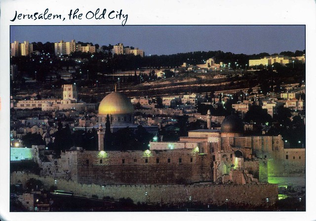
The Old City is a 0.9 square kilometre walled area within the modern city of Jerusalem; it lies within East Jerusalem. Until the 1860s this area constituted the entire city of Jerusalem. The Old City is home to several sites of key religious importance: the Temple Mount and its Western Wall for Jews, the Church of the Holy Sepulchre for Christians, and the Dome of the Rock and al-Aqsa Mosque for Muslims.


The stamps is so beautiful (and has a lighthouse on it!)! It does seem like they have lots of very nice stamps in Israel. This one is from a set of 3 stamps issued in 2009, representing Lighthouses in Israel. This one shows the lighthouse in Jaffa.

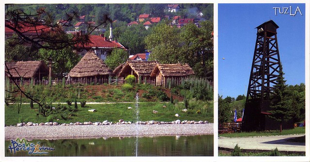
Tuzla, Bosnia and Herzegovina

This card arrived from a tag from Tiina in Finland. She's never been to Bosnia & Herzegovina but a colleague of hers visited there last year and brought her some postcards. :D The funny thing is, I'm actually waiting for some postcards to arrive directly from Tuzla at the moment, from my new penpal Snjezana. :)


Tuzla is a city and municipality in Bosnia and Herzegovina. At the time of the 1991 census, it had 131,000 inhabitants. Taking the influx of refugees into account, the city is currently estimated to have 174,558 inhabitants. After Sarajevo, and Banja Luka, Tuzla is the third largest city in Bosnia and Herzegovina, and the seat of the Tuzla Canton and Tuzla Municipality. The name "Tuzla" is derived from the Turkish word for salt, and refers to the extensive salt deposits found underneath the city.

The city of Tuzla has Europe's only salt lake as part of its central park and also has around 100,000 people visiting its shores every year. The history of the town Tuzla goes back to 1510 when Tuzla was a Turkish garrison town. During the 19th century it passed under the rule of the Austro-Hungarian Empire, and was incorporated into Yugoslavia in 1918.

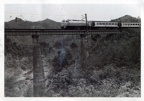
Back to the Old-Time Taiwan

This lovely black & white train postcard arrived today as an official from Taiwan.


TW-161811


There wasn't any further info about the picture on the card, except that it seems to be from a series of postcards depicting Taiwan in the past. I like seeing trains around the world. :)


Not much info about the stamps, either... I'd assume the middle one was issued this year as it's the Year of the Tiger at the moment. The picture in the stamp on the right looks like the Chinese lucky knots I've seen before (and we've got one at home, a gift from Miranda).

Thursday, 24 June 2010

Bora Bora, French Polynesia

My last card for today comes from a very far away place: French Polynesia. It was a swap with Magali - who claims the water is too fresh for her so she won't go to the beach! Personally I'd love to be on that beach at the moment, it looks so refreshing and seems like a paradise.


Bora Bora is an island in the Leeward group of the Society Islands of French Polynesia, an overseas collectivity of France in the Pacific Ocean. The island, located about 230 kilometres northwest of Papeete, is surrounded by a lagoon and a barrier reef. In the center of the island are the remnants of an extinct volcano rising to two peaks, Mount Pahia and Mount Otemanu, the highest point at 727 metres.

The major settlement, Vaitape is on the western side of the island, opposite the main channel into the lagoon. The products of the island are mostly limited to what can be obtained from the sea and coconut trees, which were historically of economic importance for copra. During the August 2007 census, the population on the island was about 8,880 people.

Today the island is mainly dependent on tourism. Over the last few years several resorts have been built on motu (small islands) surrounding the lagoon. Thirty years ago, Hotel Bora Bora built the first over-the-water bungalows on stilts over the lagoon and today, overwater bungalows are a standard feature of most Bora Bora resorts.


The stamp on the right was issued in 2007 for the celebration of Chinese New Year, that year's subject being Year of the Pig. The stamp on the right is from a set of 4 stamps issued in 2008, representing Marine Fauna. This one shows the Ray (Himantura fai).

Altai Mountains, Russia

Another postcard from Russia... This one is from my new postcard pal, Arseniy.


The postcard shows the Upper Multa Lake in Altai Mountains. The Altai Mountains are a mountain range in central Asia, where Russia, China, Mongolia and Kazakhstan come together, and where the rivers Irtysh and Ob have their sources. The Altai Mountains are known as the original locus of the speakers of Turkic as well as other members of the proposed Altaic language group.

A vast area of 16,178 km² - Altai and Katun Natural Reserves, Lake Teletskoye, Mount Belukha and the Ukok Plateau - comprise a natural UNESCO World Heritage Site entitled Golden Mountains of Altai. As stated in the UNESCO description of the site, "the region represents the most complete sequence of altitudinal vegetation zones in central Siberia, from steppe, forest-steppe, mixed forest, subalpine vegetation to alpine vegetation". While making its decision, UNESCO also cited Russian Altai's importance for preservation of the globally endangered mammals, such as snow leopard and the Altai argali. Siberian Ibex also live in these mountains.

The photo was taken by Pavel Filatov, you can see more of his STUNNING photography here.


The bigger stamp is from the Europa series, this year's theme being Children's Books and this is the Russian contribution to the series. The smaller stamp is from a set of 12 definitive stamps issued in 2009, depicting Russian Kremlins. This one shows the Moscow Kremlin.

Peterhof, St Petersburg, Russia

I'm a little surprised I haven't had more swap requests through the official postcrossing site since I changed my preferences to "yes, I'm interested in direct swaps", considering I get them all the time on the forum, despite pointing out in my signature that I'm NOT interested. (Can't people read?!?) Anyway, the following card is the first I received via a swap through the official site since changing the status. Isn't it beautiful?!


The card shows the Chinese Garden in the Lower Park of Peterhof Palace in St Petersburg, Russia. Peterhof is actually a series of palaces and gardens, laid out on the orders of Peter the Great. These Palaces and gardens are sometimes referred as the "Russian Versailles". The palace-ensemble along with the city centre is recognised as a UNESCO World Heritage Site.

Annoyingly, I couldn't find much information about the Chinese Garden or the red house. Any help would be greatly appreciated!


The stamp on the right is from a set of 3 stamps issued in 2008, representing Archeological Heritage of Russia, this stamp showing a metal plate featuring deer. The one next to it is from a set of 5 stamps issued in 2009, commemorating the 200th Anniversary of the Birth of N.V. Gogol (1809-1852), this stamp showing "Tarars Bulba" (1835). The small stamps are from a set of 15 definitive stamps issued in 2008, showing animals. Here you can see the Hare and Fox.

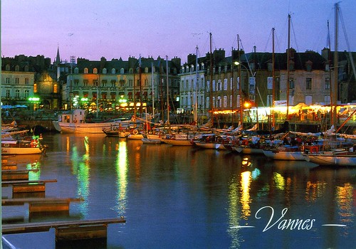
Vannes, France

This week has been really warm and sunny, not very typical in England! I really enjoy it, although I do wish it didn't make my hay fever worse... I've been sneezing SO much recently, and yesterday and today my eyes have been feeling a bit funny as well. :( Oh well, I still prefer this to the usual cold and rain.

I don't know if it's the heat, but I haven't really been in the mood to write lots of postscards recently. I'm enjoying the Finnish "Summer RR", but I haven't been sending all that many officials. Which is why I haven't been receiving many, either.. I did get one very nice official today, though.


FR-98777


This lovely postcard came from Emmanuelle in France. Vannes is a small town in Brittany in north-western France. It was founded over 2000 years ago. Vannes is located on the Gulf of Morbihan at the mouth of the river Vannes. It is around 100 km northwest of Nantes and 450 km south west of Paris. Vannes is a market town and often linked to the sea.


The stamp would seem to be an automated sticker label, but at least it's nicer than the labels that I've seen from France before (those haven't had any pictures on them).

Wednesday, 23 June 2010

Outback Australia

Another postcard from Heather... I love the colours in this one!


Heather told me that this is a really common scene for her. All the ground over there is this colour, even when they tar-seal roads. It'll be spring in Australia soon (I always keep forgetting they have winter when we have summer... And for a change it has actually been very summer-y in England this week - it's REALLY hot here! :O) which means wild flower season as well. Looks very pretty!


The stamps are from a set of 4 stamps issued earlier this year and celebrate the importance of Lachlan Macquarie (1762-1824) as Governor of New South Wales. During his time as governor (1810-1821), Macquarie provided an important vision for the colony. He embarked on a public works program, erecting churches, parsonages, courthouses, lighthouses, convict barracks and factories. These buildings would transform the physical appearance of the colony.

Australia

I've swapped a few more postcards with Heather in Australia - her cards are SO beautiful, and I love the stamps she uses as well. :) This has got to be one of my favourite postcards from her, I just love the atmosphere in this card!


The postcard shows two aboriginal sisters, don't they look happy and cute?! It makes me miss my sister... I only have one sister, but she's truly wonderful and I really miss her. I'm going to Finland for two weeks in August, I really can't wait. It'll be SO good to see my family and friends again! I haven't been there for about a year and a half now...


Back to the postcard... The stamps are great as usual. The one one the left was issued earlier this year and commemorates the birthday of Queen Elizabeth II. The stamp in the middle was issued this year, too, and comes from a set of 5 stamps with the title "Come to the Show". These stamps highlight the agriculture and royal shows that form part of the Australian calendar each year. Finally, the stamp on the right (issued this year, too) is from a set of 2 stamps with the theme Australian Commonwealth Coinage 1910-2010.

Sunday, 20 June 2010

Badshahi Mosque, Lahore, Pakistan

My last postcard for today is also from a new country to me. I haven't received any postscards from Pakistan before, but now I have one, thanks to Imran.


The Badshahi Mosque or the 'Emperor's Mosque' in Lahore is the second largest mosque in Pakistan and South Asia and the fifth largest mosque in the world. Epitomising the beauty, passion and grandeur of the Mughal era, it is Lahore's most famous landmark and a major tourist attraction.

Capable of accommodating 10,000 worshippers in its main prayer hall and a further 100,000 in its courtyard and porticoes, it remained the largest mosque in the world from 1673 to 1986 (a period of 313 years), when overtaken in size by the completion of the Faisal Mosque in Islamabad. Today, it remains the second largest mosque in Pakistan and South Asia and the fifth largest mosque in the world after the Masjid al-Haram (Grand Mosque) of Mecca, the Al-Masjid al-Nabawi (Prophet's Mosque) in Medina, the Hassan II Mosque in Casablanca and the Faisal Mosque in Islamabad.

To appreciate its large size, the four minarets of the Badshahi Mosque are 13.9 ft (4.2 m) taller than those of the Taj Mahal and the main platform of the Taj Mahal can fit inside the (25,899.9 m2) courtyard of the Badshahi Mosque, which is the largest mosque courtyard in the world.


The stamp at the top was issued in 1994 and is from a set of 12 stamps featuring Mohammed Ali Jinnah, while the stamp at the bottom is from a set of 4 stamps issued in 2009, representing the National Year of Environment 2009. This stamp shows the Deodar.

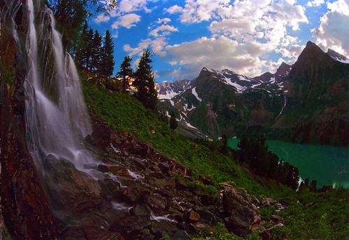
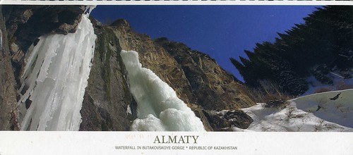
Waterfall in Butakovskoye Gorge, Kazakhstan

This card arrived at the same time with the other Kazakhstan postcard and is also from Assel. Thank you!


This card shows Butakovskoye Gorge near Almaty city. There are high mountains, big waterfalls and even some wild animals there. This is what Assel told me of the place, I couldn't find any other info about it.


The stamp is from a set of 4 stamps issued in 2007, representing Olympic Champions from Kazakhstan. This one shows Vladimir Smirnov.

Almaty, Kazakhstan

I have to say I know hardly anything about Kazakhstan (or any other central Asian states, for that matter), and I think I've only received one postcard from there before this (and the one in the following post). It does look pretty impressive, though. Thank you for the swap, Assel!


This card shows the Central State Museum in Almaty. Almaty is the largest city in Kazakhstan, with a population of 1,348,500 (as of 1 September 2008), which represents 9% of the population of the country. It was the capital of Kazakhstan (and its predecessor, the Kazakh SSR) from 1929 to 1997. Despite losing its status as the capital to Astana, Almaty remains the major commercial center of Kazakhstan.

Almaty is situated in the center of the Eurasian continent on the southeast of the Republic of Kazakhstan in longitude 77 East and 43 latitude North on the bottom of Zailiisky Alatau – the most northern mountain range of TyanShan. Gagri and Vladivostok are situated on the same parallel.

The Almaty climate is sharply continental with significant temperature fluctuations during the year and the day. At the 500-meter height you can see city streets directed to the north, steppes, hottest Prikaskelenskiye Muyunkumy. You can feel glaciers’ breath in the residential areas on the south while being at the 1500-1700 meter height over the sea level in Medeu and Kamenskiy Plato tracts.

Flora and fauna of Zailisky Alatau are impressively diverse and luxuriant. Almaty suburbs are considered to be the part of the Ile-Alatauski national park that is hosting natural reservations and wildlife sanctuaries. Most rare kinds of birds and animals that live on the protected territories are recorded in the Red Book of Kazakhstan, including a snow leopard (irbis) that is now depicted on the Almaty emblem.

At the bottom of the mountains tobacco, melon, grain and grapes plantations are replaced by orchards and berry fields. Over 8 thousand hectares of the city territories are cultivated and planted with gardens, parks, squares and boulevards. This is the place of origin of the Almatinskiy aport.

The city area is over 170 square meters and situated between the Bolshaya and Malaya rivers and their inflows. City rivers and lakes are the main water supply sources for Almaty.


The big stamp is a commemorative stamp issued in 2008, representing Torch Relay of Olympic Games. The stamp at the bottom is from a set of 3 stamps issued in 2007, for Centenary of Birth of Maulen Balakaev. The other green stamp is from a set of 8 definitive stamps issued in 2006, representing Astana. The stamp on the top was also issued in 2006 and is from a set of 4 stamps, issued for the 75th Birth Anniversary of Mukafali Makataev.

Kilpisjärvi, Finland

I love receiving postcards from Finland. It's always good to hear about people in my native country, and it's great to read (and write, too) cards in Finnish. I find Lapland particularly fascinating, even if I've never been there myself. The following card is an official I received a few days ago, and I find it quite interesting.


FI-828094


Kilpisjärvi is one of the more remote places in Finland. Located 450 kilometres north of Rovaniemi (and this is where the maps on postcrossing fail - the map on the sender's profile points to Rovaniemi!). Kilpisjärvi is located in Enontekiö municipality in northwestern Finland. It is on the border of Sweden and Norway high above the Arctic Circle. Distance to the Arctic Ocean is less than 50 kilometers. The village is almost 500 meters above the sea level. The word Kilpisjärvi is both the name of the lake and the village.

Although Kilpisjärvi is one of the largest villages in Enontekiö, it is still quite small. In 2000 its population was recorded as 114. It does have a very informative website, however. Below is some info I got from there:

KILPISJÄRVI IN A NUTSHELL
- Europe's cleanest air
- 40 over 1000 meter high peaks
- Only 50 kilometres to the shore of Arctic Ocean
- Sun is above horizon from May to August
- Rare plants and birds
- Three Border Point
- Paradise for a photographer
- Favourite activities: skiing, hiking, snowmobiling, photography, fishing, husky rides, plane rides, paragliding, heli-skiing, trips to Norway and Sweden
- GPS-Location: 69°02'N - 20°47'E

CLIMATE
- The longest winter and thickest snow in Finland
- The longest ski-season: from September 'till Midsummer Day
- More Northern Lights than anywhere else in Finland
- Average temperature: in January -13,6°C, in July +10,9°C
- Average temperature all year round -2,3°C

FINLAND-WIDE CLIMATE RECORDS HELD BY KILPISJÄRVI
- Biggest recorded snowfall in one day: 48 cm (29.1.1981)
- Thickest average snow: 190 cm (19.4.1997)

The sender, Ari, tells me that there are around 5000 people there ice fishing on Sundays! They still have snow there, too, and the lake hasn't defrosted yet. Ugh, I wouldn't want to live there...


I love the special cancellation with the reindeer! :) The stamp is from a set of 5 stamps called "Jumping for joy", issued earlier this year.
Krka National Park, Croatia

More outstanding natural beauty, this time from Croatia. This one arrived from a swap with Roberto, but I also have a lovely postcard pal, Nives, there, so I've been fortunate to see glimpses of this beautiful country.


Krka is one of the Croatian national parks, named after the river Krka that it encloses. It is located in central Dalmatia, in Šibenik-Knin county, downstream of Miljevci area and just a few kilometers northeast of the city of Šibenik. It was proclaimed a national park in 1985 and is the seventh national park in Croatia. It is intended primarily for scientific, cultural, educational, recreational, and tourism activities. Due to its special position and the mosaic distribution of various types of habitats, it is characterized by exceptionally rich and varied flora and fauna. Eight hundred and sixty species and subspecies of plants have been identified within the territory of the Krka National Park, including several endemic Illyrian-Adriatic species.

This card shows the beautiful Skradinski buk waterfall. The combined waters of the Krka and Čikola Rivers flow over the 17 steps at Skradinski buk, distributed along the 800 metres in length. The width of the cascades is between 200 and 400 metres with a total height difference of 45.7 metres. Travertine formations in the upper portion of the river include thresholds, travertine islands, draperies and barriers, while the lower portion has caves and tufts. A walking trail has been constructed over the river.


The stamps on the card are very pretty, too. The stamp on the left is from a set of 5 stamps issued in 2008, portraying Croatian Ethnographic Heritage. This one shows Folk costume from Bizovac. The stamp in the middle was issued this year and is from a set of 3 stamps representing Croatian fruits. This one here shows the Woodland strawberry. The stamp on the right was also issued this year and is from a set of 4 stamps depicting famous Croats. The person here is the art historian and university teacher Grgo Gamulin.

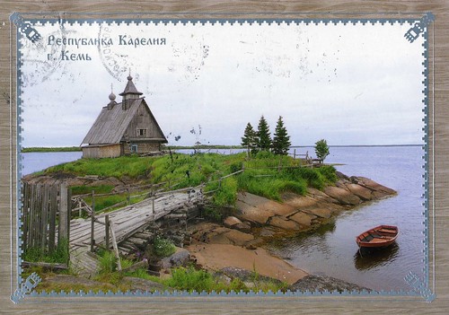
Kem, Karelia, Russia

This card arrived from a tag from Tatyana in Russia. It's SUCH a beautiful view, but sadly, the area it depicts is a little controversial.


This card shows a little church in Kem, a historic town in the Republic of Karelia, Russia, located on the railroad leading from Petrozavodsk to Murmansk. The town is located on the shores of the White Sea, where the Kem River enters it.

Karelia (Karelian and Finnish Karjala), the land of the Karelian peoples, is an area in Northern Europe of historical significance for Finland, Russia, and Sweden. It is currently divided between the Russian Republic of Karelia, the Russian Leningrad Oblast, and Finland (the regions of South Karelia (where I'm from) and North Karelia).

Various subdivisions may be called Karelia. Finnish Karelia was a historical province of Finland, now divided between Finland and Russia, often called just Karjala in Finnish. The eastern part of this chiefly Lutheran area was ceded to Russia after the Winter War of 1939-40. This area is the "Karelia" of the Karelian question in Finnish politics (and still a sensitive topic to many people, although personally I can't be bothered about the issue, I don't really care).

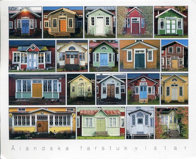
Verandas from Åland, Finland

This card is also from the Finnish Summer RR, sent to me by Eija who was visiting her daughter on the Åland islands.


Not much to say about this postcard except that I really love it! These verandas look so cute and colourful, and there are some lovely little details in the pictures such as the hearts in the top left picture.


I REALLY like the stamps! The one on the top left is, I believe, an automated sticker label, but SO much nicer than most of those labels I've seen from other countries. The stamp next to it is from a set of 4 stamps issued in 2000, representing elks. The stamp underneath is from a set of 2 stamps issued in 2002, representing Batrachians and Reptiles. This one shows the Smooth snake.

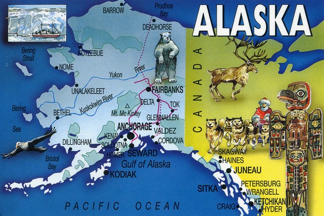
Alaska, USA

Moving on... From Mexico to its neighbour in the north, the USA. The next two cards come from the northernmost US state, Alaska. Thank you for the swap, Amy!


Alaska is the largest state of the United States by area; it is situated in the northwest extremity of the North American continent, with Canada to the east, the Arctic Ocean to the north, and the Pacific Ocean to the west and south, with Russia further west across the Bering Strait. Approximately half of Alaska's 698,473 residents live within the Anchorage metropolitan area. As of 2009, Alaska remains the least densely populated state of the U.S.


The second card shows Juneau, the state capital of Alaska.

The area of Juneau is larger than that of Rhode Island and Delaware individually and almost as large as the two states combined. Downtown Juneau is nestled at the base of Mount Juneau and across the channel from Douglas Island. As of the 2000 census, the City and Borough had a population of 30,711. The U.S. Census Bureau's 2008 population estimate for the City and Borough was 30,988.

Interesting fact that Amy told me of Juneau: You can only get to and from Juneau by boat or airplane. It's the only US state capital that isn't connected to anywhere else by road.


The stamps are all definitives. The flag with the Statue of Liberty doesn't need any explanation, I believe, but I'm not sure what the animal is...

Day of the Dead

One more card from Cipa in Mexico.. This is also one of my favourites.


Día de Muertos is Spanish for 'Day of the Dead'. It is a holiday celebrated in Latin America and by Latin Americans living in the United States and Canada. The holiday focuses on gatherings of family and friends to pray for and remember friends and family members who have died. The celebration occurs on November 2 in connection with the Catholic holidays of All Saints' Day (November 1) and All Souls' Day (November 2). Traditions connected with the holiday include building private altars honoring the deceased using sugar skulls, marigolds, and the favorite foods and beverages of the departed, and visiting graves with these as gifts. Due to occurring shortly after Halloween, the Day of the Dead is sometimes thought to be a similar holiday, although the two actually have little in common. The Day of the Dead is a time of celebration, where partying is common.

The Day of the Dead celebrations in Mexico can be traced back to the indigenous cultures. Rituals celebrating the deaths of ancestors have been observed by these civilizations perhaps for as long as 2500–3000 years. In the pre-Hispanic era, it was common to keep skulls as trophies and display them during the rituals to symbolize death and rebirth.

The festival that became the modern Day of the Dead fell in the ninth month of the Aztec calendar, about the beginning of August, and was celebrated for an entire month. The festivities were dedicated to the god known as the "Lady of the Dead," corresponding to the modern Catrina.

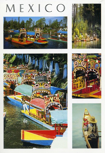
Xochimilco, Mexico

This card is also from Cipa. It shows Xochimilco, one of the sixteen boroughs within Mexican Federal District. It is located within Mexico City, 28 kilometres south of the city center. It is also a Unesco site.


The name 'Xochimilco' comes from the Nahualt (native Mexican language in Aztec times) words: 'xochitl' ('flower'), 'mil' ('field'), 'co' ('place'), so the meaning is 'Place of Flower Field'.

Xochimilco is famous for its canals, and its colourful boats called "Trajineras" which are decorated with flowers. This place is a very touristic attraction, you can hire a trajineara and navigate by the canals, around canals you will find stands which sell flowers and plants.

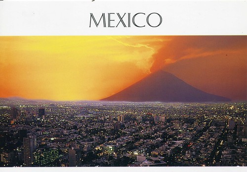
Mexico City

Another card from Cipa. I wasn't originally going to post this one, but I love the story on the back of the card.


There are many versions in popular Mexican culture of supposed accounts of the mountains in Aztec mythology. For instance, in one version Iztaccíhuatl was a princess in an Aztec tribe. When she came of age, her father wanted her to marry an Aztec prince; however, she did not like any of them. One day by chance, she saw a prince named Popocatépetl in the street. He was the prince of a different indigenous tribe in Mexico (the Chichimeca tribe), so when he wrote a letter asking the emperor if he could marry his daughter, the emperor was furious and would not allow it. Iztaccíhuatl insisted on the marriage, though, so the emperor agreed to it on one condition: Popo and his tribe must help the emperor's troops in a war against their enemy. The emperor intended on the prince dying in the war.
Popo and the rest of the Chichimecas joined the Aztecs in war, but the Aztecs abandoned them at the height of the battle. Miraculously, the Chichimecas were still triumphant without the Aztecs' help. Even so, the emperor told his daughter that Popo had died in battle, and he wrote a letter to Popo saying that Iztaccíhuatl had died of sadness in his absence. Popo did not believe the emperor, and sneaked into the palace to reunite with Iztac. Together, they ran away to get married. When the emperor found out, he disowned his daughter and proclaimed she was dead to him.

Iztac and Popo built a humble house and lived happily for a few years. Suddenly, Iztac got sick and died, in spite of Popo's efforts to save her. An earthquake occurred, and two volcanoes formed. A voice from the heavens ordered Popo to bring Iztac's body to the peak of one of the volcanoes. He obeyed and placed Iztac's body on top of a bed of flowers on the volcano. Popo then lay down next to her and waited to die. Years later, snow covered their dead bodies and they became two mountains. Popo became the mountain with smoke, (known as montaña humeante "smoking mountain") and Iztac became the mountain without (known as mujer blanca "white woman"). The two mountains are named after the lovers to this day.
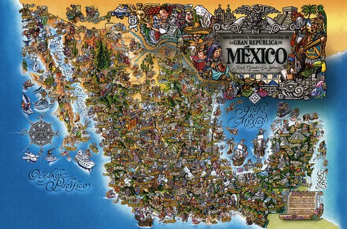
Mexico map

I'll be posting a few more Mexican cards today. I received an envelope full of lovely postcards from Cipa in Mexico, and want to share some of them.


I love map postcards, it's always fun to find new places and little details in them. This is a little different, it's an "artistic, touristic and cultural map of the Great Republic of Mexico". :) Quite hard to read, but I just love this card!


These were the stamps on the envelope. I couldn't find any info about them, but the theme would seem to be human rights.

I'm still a little confused about the cancellations. They are dated 9 June, but Cipa sent the envelope in May! I wonder where the envelope had been all that time... although I think I've heard of this happening with the Mexican post before, so maybe it's not so unusual?

Thursday, 17 June 2010

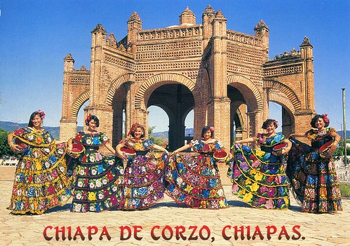
Chiapa de Corzo, Chiapas, Mexico

I've been doing quite a lot of private swaps recently, this is one of the latest received cards for me. I don't get too much mail from Mexico; I've got a couple of rather old cards that my grandma and her husband sent me when they were on a holiday in Mexico (I think that was probably in the early 1990s). I did get an envelope full of lovely postcards from Mexico a few days ago, but more about that later.


The card shows traditional dresses in Chiapa de Corzo, Chiapas. Chiapa de Corzo is a small city and municipality situated in the west-central part of the Mexican state of Chiapas (the southernmost state of Mexico, located towards the southeast of the country). Located in the Grijalva River valley of the Chiapas highlands, Chiapa de Corzo lies some 15 km to the east of the state capital, Tuxtla Gutiérrez. The city had a 2005 census population of 37,627 and serves as municipal seat of the municipality of the same name, which has an area of 906.7 km² and reported a population of 73,552 inhabitants.

The Chiapas highlands region has been inhabited since at least the Archaic period of Mesoamerican history. The nearby pre-Columbian Mesoamerican archaeological site, also known as Chiapa de Corzo, shows evidence of continual occupation since the Early Formative period ( ca. 1400 BCE). The mounds and plazas at the Chiapa de Corzo archaeological site date to approximately 700 BCE with the temple and palace constructed during the Late Formative, perhaps 400 BCE to 200 CE.

Thank you for the swap, Diego!


I couldn't find any info about the plane stamp, but from what I can tell, it commemorates 100 years of aviation in Mexico.

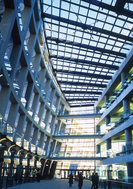
The City Library, Salt Lake City, USA

I love reading and usually always carry a book with me wherever I go. I also love spending time in libraries, and I love seeing libraries around the world. Postcrossing has been very helpful in this respect, and it's always a treat to receive official cards such as this.


US-723326


This is the City Library in Salt Lake City, Utah, USA. On the back it says: "Salt Lake City's newest landmark is a truly awe inspiring place for the community to gather, and learn. This new architectural masterpiece was finished in 2003 and will be a place of young and old to celebrate Salt Lake City's culture and diversity."

I found some more info about this library as well:

The Salt Lake City Public Library has been located in a few different places. After celebrating the library's 100th anniversary in early 1998, an $84 million library bond was approved to move the library north half a block to its current location. The firm of Moshe Safdie and Associates and local architects in VCBO Architecture designed the building, which opened to the public on February 8, 2003. The Salt Lake City main library is a 22,300 m² five-story tall, wedge-shaped building. The library has a collection of over 500,000 books as well as subscriptions to over 60 newspapers and magazines and 163 internet capable computers. The whole library depends on natural lighting, reducing the need of lights in the library. A huge five story glass wall is where most of the light comes from.

Kiipsaare Daymark, Estonia

Another lighthouse from Estonia...


Info from the back of the card:

KIIPSAARE DAYMARK on the Harilaid Peninsula, Saaremaa Island, Estonia
Height from bottom 25 m
The lighthouse (1933), inactive today, is famous for its leaning tower and scenic location.
The wave erosion has severely undermined the basement of the tower, as a result, it has become inclined seaward.


I can't help feeling jealous that people in so many countries can still get hold of old stamps. Here in the UK it's difficult to find anything that was issued over a year ago. :( Anyway, here the stamp on the left is a commemorative stamp issued in 2000, celebrating the Tallinn Zoo. The animal is the Amur Long-Tailed Goral. The stamp on the right was issued in 2008 and shows the Kalvi Hall manor hall on the high North Estonian limestone coast.

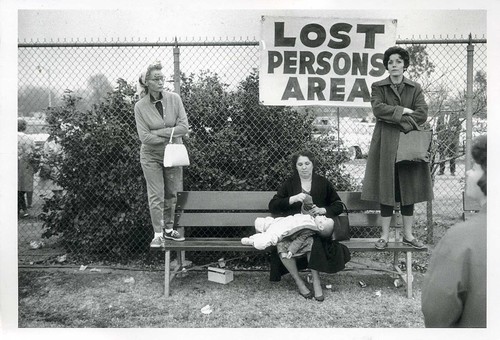
Lost Persons Area

This fun card arrived from a tag from Jitka in Czech Republic a couple of days ago.


I hadn't heard of Elliott Erwitt before but I had to check him out now. He seems like my kind of photographer, too. :) You can find out more here.

Hhmmmm, I wonder when I'm going to lost myself as well.. I wouldn't be too surprised :P


Isn't it a beautiful stamp?! It's from a set of 2 stamps issued this year, celebrating the 150th anniversary of the birth of Alphonse Mucha.

Tuesday, 15 June 2010

Panama

I might have mentioned that I don't get too many officials from smaller countries... Well, yesterday was a lovely exception - I found a postcard from Panama amongst my mail!


PA-164


The funny thing is, I recently arranged a private swap from Panama and at first I thought this was the swap card (it would've arrived really quickly!). ...until I noticed there was a postcard ID on the card. Mmmhh, this is my first written and stamped postcard from Panama - I think I have one that was sent from the USA, and one unwritten card.

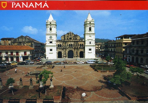
On the card you can see Panama City Cathedral and square. Freddy, who sent me the card, tells me that the Cathedral was built between 1688 and 1796. I did some research online and also found the following:

The Cathedral is located in the old quarter of the city (also commonly referred to as "Casco Viejo", "Casco Antiguo" or "San Felipe"). Panamá was the first European settlement on the Pacific coast of the Americas, in 1519, and the Historic District preserves intact a street pattern, together with a substantial number of early domestic buildings, which are exceptional testimony to the nature of this early settlement. Therefore, Casco Antiguo was designated a World Heritage Site. After the first settlement was destroyed by diseases and the pirate attacks, the last and most remembered one by Henry Morgan, the city moved into a rocky peninsula that was both healthier and easier to defend. In 1673 they founded what today is called officially Casco Antiguo, but is also known as San Felipe, Catedral and more commonly, Casco Viejo.

Currently under a revitalization process, Casco Antiguo is a mix of different architectural styles, which reflects the cultural diversity of the country. Caribbean, Republican, Art Deco, French and Colonial mix in a site of less than 800 buildings. Most of Panama´s City´s main monuments are located in Casco Antiguo, including the Salón Bolivar, the main Cathedral (Catedral Metropolitana), the National Theatre (founded in 1908), and Las Bovedas Monument.

Panama City (Spanish: Panamá) itself is the capital and largest city of the Republic of Panama. It has a population of 813,097, with a total metro population of 1,206,792, and it is located at the Pacific entrance of the Panama Canal.


The stamps are lovely, too. The bottom one is from a set of 4 stamps issued in 2007, representing the Red-backed squirrel monkey. The one in the middle is from a set of 4 stamps issued in 2002, representing Corals of Panama, this one showing Montastraea annularis Ellis and Solander. The stamp on top is also from a set of 4 stamps issued in 2002, representing Artistic Treasures of the Palace "Las Garzas".

North Uist, Scotland

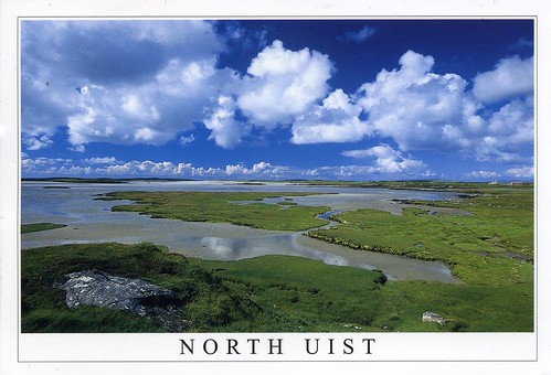
Another card from the Western Islands in Scotland and also from Sarah (who doesn't seem to be active on postcrossing anymore :( ). I received this one last year as well, but it's such a lovely card that it definitely deserves a spot here. :)


This card shows Vallay Strand in North Uist. Uist (or The Uists) are the central group of islands in the Outer Hebrides of Scotland. The Outer Hebrides is a chain of more than 100 islands and small skerries located about 70 kilometres west of mainland Scotland. There are 15 inhabited islands in this archipelago, which is also known as the Western Isles and archaically as the Long Isle.

Lewis and Harris is the largest island in Scotland and the third largest in the British Isles, after Great Britain and Ireland. It incorporates Lewis in the north and Harris in the south, both of which are frequently referred to as individual islands, although they are joined by a land border. The largest settlement in Lewis and in the Outer Hebrides is Stornoway.

The Outer Hebrides had a population of 26,502 in 2001. The area has historically been a strong Scottish Gaelic (Gàidhlig) speaking area. Despite recent declines, in the 2001 census more than 50% of the resident population in each island was able to speak Gaelic, for an overall total of 15,842 speakers throughout the archipelago. The modern economy centres on tourism, crofting, fishing, and weaving, the latter of which includes the manufacture of Harris tweed. The archipelago is exposed to wind and tide, and there are numerous lighthouses as an aid to navigation.

Monday, 14 June 2010

St Kilda, Scotland

I thought I'd throw in a random card as I'm currently transferring (a ton of) photos from my laptop to an external harddrive, and it's taking ages. :S I received this card last year and it's still one of my favourites. It's very beautiful, AND it's from Scotland and a Unesco site as well.


This volcanic archipelago, with its spectacular landscapes, is situated off the coast of the Hebrides and comprises the islands of Hirta, Dun, Soay and Boreray. It has some of the highest cliffs in Europe, which have large colonies of rare and endangered species of birds, especially puffins and gannets. The archipelago, uninhabited since 1930, bears the evidence of more than 2,000 years of human occupation in the extreme conditions prevalent in the Hebrides. Human vestiges include built structures and field systems, the cleits and the traditional Highland stone houses. They feature the vulnerable remains of a subsistence economy based on the products of birds, agriculture and sheep farming.

You can read more about St Kilda here. Sarah, who sent me this card, told me that she can see this place on the horizon from her village!


The stamp is from a set of 6 stamps representing Cathedrals, issued in 2008. This one shows the Lichfield Cathedral.