Saturday 4 October 2014

Lowland rainforest, Masoala National Park, Madagascar

Today's last card is from a swap from earlier this year. It's also my first postcard from Madagascar - and it's written and stamped, too!


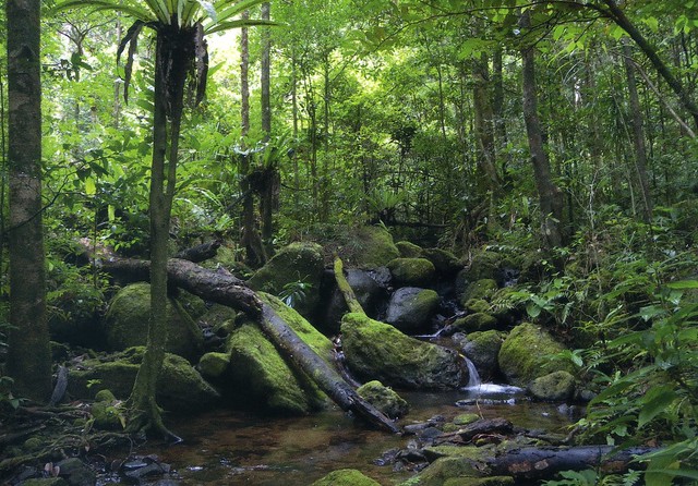
The Rainforests of the Atsinanana comprise six national parks distributed along the eastern part of the island. These relict forests are critically important for maintaining ongoing ecological processes necessary for the survival of Madagascar’s unique biodiversity, which reflects the island’s geological history. Having completed its separation from all other land masses more than 60 million years ago, Madagascar’s plant and animal life evolved in isolation. The rainforests are inscribed for their importance to both ecological and biological processes as well as their biodiversity and the threatened species they support. Many species are rare and threatened especially primates and lemurs.

Madagascar, then, is an island country in the Indian Ocean, off the coast of Southeast Africa. The nation comprises the island of Madagascar (the fourth-largest island in the world), as well as numerous smaller peripheral islands. Following the prehistoric breakup of the supercontinent Gondwana, Madagascar split from India around 88 million years ago, allowing native plants and animals to evolve in relative isolation. Consequently, Madagascar is a biodiversity hotspot; over 90 percent of its wildlife is found nowhere else on Earth. The island's diverse ecosystems and unique wildlife are threatened by the encroachment of the rapidly growing human population and other environmental threats.

 Initial human settlement of Madagascar occurred between 350 BC and AD 550 by Austronesian peoples arriving on outrigger canoes from Borneo. These were joined around AD 1000 by Bantu migrants crossing the Mozambique Channel from East Africa. Other groups continued to settle on Madagascar over time, each one making lasting contributions to Malagasy cultural life. The Malagasy ethnic group is often divided into eighteen or more sub-groups of which the largest are the Merina of the central highlands.

Until the late 18th century, the island of Madagascar was ruled by a fragmented assortment of shifting socio-political alliances. Beginning in the early 19th century, most of the island was united and ruled as the Kingdom of Madagascar by a series of Merina nobles. The monarchy collapsed in 1897 when the island was absorbed into the French colonial empire, from which the island gained independence in 1960. The autonomous state of Madagascar has since undergone four major constitutional periods, termed Republics. Since 1992 the nation has officially been governed as a constitutional democracy from its capital at Antananarivo. However, in a popular uprising in 2009 president Marc Ravalomanana was made to resign and presidential power was transferred in March 2009 to Andry Rajoelina in a move widely viewed by the international community as a coup d'état. Constitutional governance was restored in January 2014 when Hery Rajaonarimampianina was named president following a 2013 election deemed fair and transparent by the international community.

In 2012, the population of Madagascar was estimated at just over 22 million, 90 percent of whom live on less than two dollars per day. Malagasy and French are both official languages of the state. The majority of the population adheres to traditional beliefs, Christianity, or an amalgamation of both. Ecotourism and agriculture, paired with greater investments in education, health and private enterprise, are key elements of Madagascar's development strategy. Under Ravalomanana these investments produced substantial economic growth but the benefits were not evenly spread throughout the population, producing tensions over the increasing cost of living and declining living standards among the poor and some segments of the middle class. As of 2014, the economy has been weakened by the recently concluded political crisis and quality of life remains low for the majority of the Malagasy population.

Gogana Village, Bhutan

This is my first ever Bhutan postcard so it's pretty special to me, even if it wasn't mailed directly from Bhutan (but then, I don't really expect to ever receive one). Kim from Taiwan was kind enough to swap with me for this a couple of years ago.


Bhutan, officially the Kingdom of Bhutan, is a landlocked country in South Asia located at the eastern end of the Himalayas. It is bordered to the north by China and to the south, east and west by India. To the west, it is separated from Nepal by the Indian state of Sikkim, while further south it is separated from Bangladesh by the Indian states of Assam and West Bengal. Bhutan's capital and largest city is Thimphu.

Bhutan existed as a patchwork of minor warring fiefdoms until the early 17th century, when the lama and military leader Shabdrung Ngawang Namgyal, fleeing religious persecution in Tibet, unified the area and cultivated a distinct Bhutanese identity. Later, in the early 20th century, Bhutan came into contact with the British Empire and retained strong bilateral relations with India upon its independence. Bhutan is the only country to have officially adopted gross national happiness instead of the gross domestic product as the main development indicator. In 2006, based on a global survey, Business Week rated Bhutan the happiest country in Asia and the eighth-happiest in the world.

Bhutan's landscape ranges from subtropical plains in the south to the sub-alpine Himalayan heights in the north, where some peaks exceed 7,000 metres. Its total area was reported as approximately 46,500 km2 in 1997 and 38,394 square kilometres in 2002. Bhutan's state religion is Vajrayana Buddhism and the population, now (as of 2012/2013) estimated to be nearly three-quarters of a million, is predominantly Buddhist. Hinduism is the second-largest religion.

In 2008, Bhutan made the transition from absolute monarchy to constitutional monarchy and held its first general election. As well as being a member of the United Nations, Bhutan is a member of the South Asian Association for Regional Cooperation (SAARC) and hosted SAARC's sixteenth summit in April 2010.

Kim also told me that Bhutan was the last country in the world without television - the country didn't have a TV until 1999! That's pretty impressive I'd say. Apparently Bhutan also doesn't have any traffic lights. They installed a traffic light once but people didn't like it, they preferred the traditional traffic officer.

Jersey

I'm not usually lucky enough to get into groups in the Vacation RR on the Postcrossing forum but last year I got lucky and managed to squeeze into a Jersey group, I'd love to visit the island myself some day (and send lots of postcards :D) but it seems like such an expensive place, there's no way I could afford it and I don't think Matt would be too bothered in the first place. Anyway, at least I can see glimpses in postcards. :)


This is a view from Rozel Harbour. Rozel is an area on the north east coast of Jersey in the parishes of St Martin and Trinity, a small sheltered cove that was home to a small fishing fleet and in 1829 a harbour was built for the increasing numbers of vessels involved in the oyster dredging fishery which eventually collapsed at the end of the 19th century.


The card below is unfortunately not written and stamped. I found it on ebay and thought why not, I really like map cards and the changes of actually receiving a written & stamped one from Jersey are pretty slim.


Jersey, officially the Bailiwick of Jersey, is a possession of the Crown in right of Jersey, off the coast of Normandy, France. The bailiwick consists of the island of Jersey, along with surrounding uninhabited islands and rocks collectively named Les Dirouilles, Les Écréhous, Les Minquiers, Les Pierres de Lecq, and other reefs. Jersey is part of the ancient Duchy of Normandy, and is ruled by the Duke of Normandy—a title held by the reigning Monarch of the United Kingdom, though unrelated to those duties as king or queen of the UK.
 Jersey is a self-governing parliamentary democracy under a constitutional monarchy, with its own financial, legal and judicial systems, and the power of self-determination.

The island of Jersey is the largest of the Channel Islands. Although the Bailiwicks of Jersey and Guernsey are often referred to collectively as the Channel Islands, the "Channel Islands" are not a constitutional or political unit. Jersey has a separate relationship to the British Crown from the other Crown dependencies of Guernsey and the Isle of Man. It is not part of the United Kingdom, and has an international identity separate from that of the UK but the United Kingdom is constitutionally responsible for the defence of Jersey. The Commission have confirmed in a written reply to the European Parliament in 2003 that Jersey is within the Union as a European Territory for whose external relationships the United Kingdom is responsible. Jersey is not fully part of the European Union but has a special relationship with it, notably being treated as within the European Community for the purposes of free trade in goods.

Urnes Stave Church, Norway

I was the Finnish 'winner of the month' on the Postcrossing forum two years ago. This is one of the cards I received and also one of my favourites. I have a soft spot for Norwegian postcards and this one is a Unesco site as well. ...and an ad card from Finland, which I never would've guessed by just looking at the card. It does make me a little sad now as well, because the card was sent by dear Marja who's sadly not with us anymore. I do miss her on the forum :( I hope her family and everyone close to her are ok.


Urnes Stave Church is a 12th-century stave church at Ornes, along the Lustrafjorden in the municipality of Luster in Sogn og Fjordane county, Norway. It sits on the eastern side of the fjord, directly across the fjord from the village of Solvorn and about 5 kilometres east of the village of Hafslo. It has been owned by Fortidsminneforeningen (Society for the Preservation of Norwegian Ancient Monuments) since 1881. In 1979, the Urnes Stave Church was listed as a World Heritage Site by UNESCO.

Yugoslavia map

It's been a while since I posted here again. Uh-oh... Not much has been going on and I haven't even received that many postcards. ...but then again, it's not like I've sent too many, I just can't afford it.

A bit of self-promoting for the day: I'm in the Postcrossing spotlight! I can't help wondering who gave my name to the Postcrossing team and asked for me to be included.. as it does seem like they take recommendations when someone gets interviewed.  I hope the person I suggested will get interviewed as well :)

Anyway, I thought I'd try to post a few cards today, starting with this lovely meet-up card I received from dear Snjezana last year.


I had been hoping to receive this for a while so I was really excited to find it in my mailbox. And better yet - to see familiar signatures on the back of the card :)