Tuesday 19 January 2016

Butrint, Albania

One more card for today. I've received a few postcards of Albania before but this is the first one actually mailed from Albania. I thought I'd never get one... :o I really like the colours here, too. Oh, and it's a Unesco card as well! :)


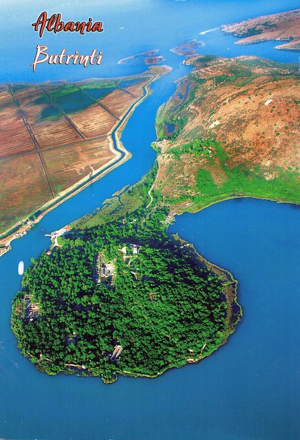
Butrint, located in the south of Albania approximately 20km from the modern city of Saranda, has a special atmosphere created by a combination of archaeology, monuments and nature in the Mediterranean. With its hinterland it constitutes an exceptional cultural landscape, which has developed organically over many centuries. Butrint has escaped aggressive development of the type that has reduced the heritage value of most historic landscapes in the Mediterranean region. It constitutes a very rare combination of archaeology and nature. The property is a microcosm of Mediterranean history, with occupation dating from 50 000 BC, at its earliest evidence, up to the 19th century AD. Prehistoric sites have been identified within the nucleus of Butrint, the small hill surrounded by the waters of Lake Butrint and Vivari Channel, as well as in its wider territory. From 800 BC until the arrival of the Romans, Butrint was influenced by Greek culture, bearing elements of a “polis” and being settled by Chaonian tribes. In 44 BC Butrint became a Roman colony and expanded considerably on reclaimed marshland, primarily to the south across the Vivari Channel, where an aqueduct was built. In the 5th century AD Butrint became an Episcopal centre; it was fortified and substantial early Christian structures were built. After a period of abandonment, Butrint was reconstructed under Byzantine control in the 9th century. Butrint and its territory came under Angevin and then Venetian control in the 14th century. Several attacks by despots of Epirus and then later by Ottomans led to the strengthening and extension of the defensive works of Butrint. At the beginning of the 19th century, a new fortress was added to the defensive system of Butrint at the mouth of the Vivari Channel. It was built by Ali Pasha, an Albanian Ottoman ruler who controlled Butrint and the area until its final abandonment.

The fortifications bear testimony to the different stages of their construction from the time of the Greek colony until the Middle Ages. The most interesting ancient Greek monument is the theatre which is fairly well preserved. The major ruin from the paleo-Christian era is the baptistery, an ancient Roman monument adapted to the cultural needs of Christianity. Its floor has a beautiful mosaic decoration. The paleo-Christian basilica was rebuilt in the 9th century and the ruins are sufficiently well preserved to permit analysis of the structure (three naves with a transept and an exterior polygonal apse).

Hakaniementori, Helsinki, Finland

Ahhhh, Helsinki! I was there last month and walked past this place as well as my sister lives only a short walk away. It's such a nice area and I love the marketplace and the market hall. I was there in November last year as well and had yummy lentil soup in the soup kitchen in the market hall. :) I highly recommend 'Soppakeittiö'. :)


Hakaniemi is an unofficial district of Helsinki, the Finnish capital. It covers most of the neighbourhood of Siltasaari. It is considered a part of the Helsinki city center. Historically, it was often associated with the working class and worker's associations. However, the cost of living has risen considerably in recent years and is now on par with the rest of the downtown area of Helsinki. The best-known features of Hakaniemi include a large and lively marketplace, Oriental food stores with a good variety of Asian imported products the headquarters of several trade unions, the headquarters of the Social Democratic Party of Finland and the Left Alliance Party and the Helsinki Hilton hotel. Famous buildings include the Ympyrätalo building (architects Heikki and Kaija Sirén, 1968) and the Hakaniemi Market Hall (architect Karl Hård af Segerstad, 1914).

Hakaniemi square has been built on reclaimed land. It has been site of farmers' market since 1897.

Greetings from Turkey

I just checked, and I've only ever posted about a handful of postcards I've received from Turkey in this blog. How did that happen?! :o Well, here's one, received last year.


Turkey is a parliamentary republic in Eurasia, largely located in Western Asia, with the smaller portion of Eastern Thrace in Southeast Europe. Turkey is bordered by eight countries: Syria and Iraq to the south; Iran, Armenia, and the Azerbaijani exclave of Nakhchivan to the east; Georgia to the northeast; Bulgaria to the northwest; and Greece to the west. The Black Sea is to the north, the Mediterranean Sea to the south, and the Aegean Sea to the west. The Bosphorus, the Sea of Marmara, and the Dardanelles (which together form the Turkish Straits) demarcate the boundary between Thrace and Anatolia; they also separate Europe and Asia. Turkey's location at the crossroads of Europe and Asia makes it a country of significant geostrategic importance.

Turkey has been inhabited since the paleolithic age, including various ancient Anatolian civilizations, Aeolian, Dorian and Ionian Greeks, Thracians, Armenians, and Assyrians. After Alexander the Great's conquest, the area was Hellenized, a process which continued under the Roman Empire and its transition into the Byzantine Empire. The Seljuk Turks began migrating into the area in the 11th century, starting the process of Turkification, which was greatly accelerated by the Seljuk victory over the Byzantines at the Battle of Manzikert in 1071. The Seljuk Sultanate of Rûm ruled Anatolia until the Mongol invasion in 1243, upon which it disintegrated into several small Turkish beyliks.

Starting from the late 13th century, the Ottomans united Anatolia and created an empire encompassing much of Southeastern Europe, Western Asia and North Africa, becoming a major power in Eurasia and Africa during the early modern period. The empire reached the peak of its power between the 15th and 17th centuries, especially during the 1520–66 reign of Suleiman the Magnificent. After the second Ottoman siege of Vienna in 1683 and the end of the Great Turkish War in 1699, the Ottoman Empire entered a long period of decline. The Tanzimat reforms of the 19th century, which aimed to modernize the Ottoman state, proved to be inadequate in most fields, and failed to stop the dissolution of the empire. The Ottoman Empire entered World War I (1914–18) on the side of the Central Powers and was ultimately defeated. During the war, major atrocities were committed by the Ottoman government against its Armenian, Assyrian and Pontic Greek citizens. Following the war, the huge conglomeration of territories and peoples that formerly comprised the Ottoman Empire was divided into several new states. The Turkish War of Independence (1919–22), initiated by Mustafa Kemal Atatürk and his colleagues in Anatolia, resulted in the establishment of the modern Republic of Turkey in 1923, with Atatürk as its first president.

Turkey is a democratic, secular, unitary, constitutional republic with a diverse cultural heritage. The country's official language is Turkish, a Turkic language spoken natively by approximately 85 percent of the population. According to the World Factbook, 70–75 percent of the population are ethnic Turks, while the Kurds are the largest minority at 18%. The vast majority of the population is Sunni Muslim, with Alevis making up the largest religious minority. Turkey is a member of the UN, NATO, OECD, OSCE, OIC and the G-20. After becoming one of the first members of the Council of Europe in 1949, Turkey became an associate member of the EEC in 1963, joined the EU Customs Union in 1995 and started full membership negotiations with the European Union in 2005. Turkey's growing economy and diplomatic initiatives have led to its recognition as a regional power.

Sites of Japan’s Meiji Industrial Revolution: Iron and Steel, Shipbuilding and Coal Mining

Another smaller post for today. I was supposed to do a proper one but I got distracted earlier. :P Anyway, I'll start with this Unesco card I received from dear Sayaka last year.


Sites of Japan’s Meiji Industrial Revolution: Iron and Steel, Shipbuilding and Coal Mining

The site encompasses a series of twenty three component parts, mainly located in the southwest of Japan. It bears testimony to the rapid industrialization of the country from the middle of the 19th century to the early 20th century, through the development of the iron and steel industry, shipbuilding and coal mining. The site illustrates the process by which feudal Japan sought technology transfer from Europe and America from the middle of the 19th century and how this technology was adapted to the country’s needs and social traditions. The site testifies to what is considered to be the first successful transfer of Western industrialization to a non-Western nation.

Saturday 16 January 2016

Jewish Quarter and St Procopius' Basilica in Třebíč, Czech Republic

One more Unesco card for today. ...although the main point of this card really is the stamp - I finally have the Czech Postcrossing stamp in my collection! :) Thank you so much for the swap, Standa!


Třebíč is a town in the Moravian part of the Vysočina Region of the Czech Republic. Třebíč is situated 35 km southeast of Jihlava and 65 km west of Brno on the Jihlava River.  Třebíč has a temperate climate with occasional rains. It is a regional centre with a population of approximately 40,000.

The ensemble of the Jewish Quarter, the old Jewish cemetery and the Basilica of St Procopius in Třebíč are reminders of the co-existence of Jewish and Christian cultures from the Middle Ages to the 20th century. The Jewish Quarter bears outstanding testimony to the different aspects of the life of this community. St Procopius' Basilica, built as part of the Benedictine monastery in the early 13th century, is a remarkable example of the influence of Western European architectural heritage in this region.

Monuments of Oviedo and the Kingdom of the Asturias, Spain

A Unesco card I received from a tag last year. I still don't have too many Unesco cards from Spain... :o


In the 9th century the flame of Christianity was kept alive in the Iberian peninsula in the tiny Kingdom of the Asturias. Here an innovative pre-Romanesque architectural style was created that was to play a significant role in the development of the religious architecture of the peninsula. Its highest achievements can be seen in the churches of Santa María del Naranco, San Miguel de Lillo, Santa Cristina de Lena, the Cámara Santa and San Julián de los Prados, in and around the ancient capital city of Oviedo. Associated with them is the remarkable contemporary hydraulic engineering structure known as La Foncalada.

This card shows the church of St Mary at Mount Naranco (Iglesia de Santa María del Naranco), a Roman Catholic Asturian pre-Romanesque Asturian architecture church on the slope of Mount Naranco situated 3 kilometres from Oviedo, northern Spain. Ramiro I of Asturias ordered it to be built as a royal palace as part of a larger complex that also incorporated the nearby church of San Miguel de Lillo, 100 meters away. It was completed in 848. Its structural features, such as the barrel vault — with transverse ribs corresponding one-to-one with contraforts at the exterior, make it a clear precursor of the Romanesque construction. The exterior decorations, as well as the use of stilted arches mark the intended verticality of the composition. It was converted into a church at the end of the 13th century.


Greetings from Barbados

It's weird, I was expecting this postcard to be a lot more difficult to get sent from Barbados than it turned out to be. :o I seem to remember everyone being really confused about this card even getting printed - why choose such a rare country with hardly any Postcrossers?? It seems to be happening a lot more with the more recent issues, too... Most of the upcoming ones seem really hard/pretty much impossible to get hold of. ...although I suppose it's bound to happen as you run out of more "common" countries. :P


I'm not really sure what to say about this card... I do like the sunset (or is that a sunrise??) and the calm atmosphere.

On a random note, I would love to explore Caribbean cuisine a bit more. There are a lot of Jamaican restaurants over here but I'm not so sure of the other countries in the Caribbean... I used to read the Vegan In The Sun blog as I found it really inspiring, but then it didn't get updated for months on end. I just looked it up again and found out that it has moved here - I'll have to have a proper look soon!

Strand Hotel, Yangon, Myanmar

This is another surprise card from Jobbo, received earlier this month. Thank you ever so much, I really like it! Your travel stories have been fascinating to read about.


The Strand (also known as Strand Hotel) is a Victorian-style hotel located in Yangon, Myanmar (Burma), built by Aviet and Tigran Sarkie, two of the Sarkies Brothers. The hotel, which opened in 1901, which faces the Hlaing — or Yangon — River to its south, is one of the most famous hotels in Yangon and Southeast Asia, and is managed by GCP Hospitality. The hotel is named after its address, at 92 Strand Road.

Downtown Yangon is known for its leafy avenues and fin-de-siècle architecture. The former British colonial capital has the highest number of colonial period buildings in Southeast Asia. Downtown Yangon is still mainly made up of decaying colonial buildings. The former High Court, the former Secretariat buildings, the former St. Paul's English High School and the Strand Hotel are excellent examples of the bygone era. Most downtown buildings from this era are four-story mix-use (residential and commercial) buildings with 4.3 m ceilings, allowing for the construction of mezzanines. Despite their less-than-perfect conditions, the buildings remain highly sought after and most expensive in the city's property market.

In 1996, the Yangon City Development Committee created a Yangon City Heritage List of old buildings and structures in the city that cannot be modified or torn down without approval. In 2012, the city of Yangon imposed a 50-year moratorium on demolition of buildings older than 50 years.

Yangon is a former capital of Myanmar and the capital of Yangon Region. Yangon is the country's largest city with a population of over five million, and is the most important commercial centre, although the military government officially relocated the capital to Naypyidaw in March 2006. Although Yangon's infrastructure is undeveloped compared to those of other major cities in Southeast Asia, it has the largest number of colonial buildings in the region today. While many high-rise residential and commercial buildings have been constructed or renovated throughout downtown and Greater Yangon in the past two decades, most satellite towns that ring the city continue to be deeply impoverished.

Tuesday 5 January 2016

Finland

So I briefly mentioned that I spent this Christmas in Finland. My mum turned 60 on Christmas Day and Matt reckoned we could go over and surprise her. It took a lot of planning, starting from around late August, but was very much worth it as mum was so happy to see us (after the initial shock... :p) and told me us going over was the best present she's ever had. So yes, Christmas 2015 was pretty special, even if not very conventional. It was also a little odd to be in Finland at Christmas and there to be no snow at all in Helsinki or Lappeenranta.

...nothing like this postcard, then! Haha. This is from a swap with Lilla in Finland last year. She was kind enough to send me a postcard with the Year of the Sheep stamp sheet issued in Åland.


I have no idea of the name or location of this lighthouse, all I know is that it's located somewhere in Finland. There isn't even any room for writing on the postcard (apart from address) as the stamp sheets takes up all the space. :D

Peace Bridge, Derry, Northern Ireland

One of the few postcards I've ever received from Northern Ireland. I've got to admit that I don't know too much about Northern Ireland or the politics there, although from what I've heard, it sounds kind of complicated. I actually had a job offer from Belfast last year (or was it the year before?) but had to turn it down as it would've been way too far away and Matt couldn't really leave his job, plus neither of us knows anyone in NI or has any connections there. Who knows, it could have been interesting... :P


Derry, officially Londonderry, is the second-largest city in Northern Ireland and the fourth-largest city on the island of Ireland. The name Derry is an anglicisation of the Irish name Daire or Doire meaning "oak grove". In 1613, the city was granted a Royal Charter by King James I and gained the "London" prefix to reflect the funding of its construction by the London guilds. While the city is more usually known colloquially as Derry, Londonderry is also commonly used and remains the legal name.

The old walled city lies on the west bank of the River Foyle, which is spanned by two road bridges and one footbridge. The city now covers both banks (Cityside on the west and Waterside on the east). The city district also extends to rural areas to the southeast. The population of the city proper (the area defined by its 17th century charter) was 83,652 in the 2001 Census, while the Derry Urban Area had a population of 90,736. The district is administered by Derry City & Strabane District Council and contains both Londonderry Port and City of Derry Airport.

Derry is close to the border with County Donegal, with which it has had a close link for many centuries. The person traditionally seen as the 'founder' of the original Derry is Saint Colmcille, a holy man from Tír Chonaill, the old name for almost all of modern County Donegal (of which the west bank of the Foyle was a part before 1610.

In 2013, Derry became the inaugural UK City of Culture, having been awarded the title in July 2010.

Lübeck, Germany

A Unesco card I received last year. I'm not a huge fan of multi-view cards, but at least you get to see a few different places on this card. :P


Lübeck is a city in Schleswig-Holstein, northern Germany, and one of the major ports of Germany. On the river Trave, it was the leading city of the Hanseatic League and because of its extensive Brick Gothic architecture is listed by UNESCO as a World Heritage Site. In 2005, it had a population of 213,983.

The old part of Lübeck is on an island enclosed by the Trave. The Elbe–Lübeck Canal connects the Trave with the Elbe River. Another important river near the town centre is the Wakenitz. The Autobahn 1 connects Lübeck with Hamburg and Denmark. Travemünde is a sea resort and ferry port on the coast of the Baltic Sea. Lübeck Hauptbahnhof links Lübeck to a number of railway lines, notably the line to Hamburg.

Lübeck is famous for its marzipan industry. According to local legend, marzipan was first made in Lübeck, possibly in response either to a military siege of the city or a famine year. The story, perhaps apocryphal, is that the town ran out of all food except stored almonds and sugar, which were used to make loaves of marzipan "bread". Others believe that marzipan was actually invented in Persia a few hundred years before Lübeck claims to have invented it. The best known producer is Niederegger, which tourists often visit while in Lübeck, especially at Christmas time.

Greetings from India

I was expecting it to be really difficult to get this card sent from India, but somehow I ended up with three copies... hhmmm?!


I must say, India's post office network is pretty impressive. I do think it's alright in England as well, at least where I live. I hope the UK won't be going down the way Finland is anytime soon, with only a handful of "proper" post offices left in the whole country! That doesn't sound very nice.

Star Ferry in front of Wan Chai, Hong Kong

This is one of the several postcards I received from Jobbo last year. Thank you ever so much for contributing to this blog, I really appreciate it, and your insightful postcards have really brightened my days. I wish you all the best for your future travels!


Wan Chai is a metropolitan area situated at the western part of the Wan Chai District on the northern shore of Hong Kong Island, in Hong Kong. Its other boundaries are Canal Road to the east, Arsenal Street to the west and Bowen Road to the south. The area north of Gloucester Road is often referred to as Wan Chai North. Wan Chai is one of the busiest commercial areas in Hong Kong with offices of many small and medium-sized companies. Wan Chai North features office towers, parks, hotels and an international conference and exhibition centre. As one of the first areas developed in Hong Kong, the locale is densely populated yet with noticeable residential zones facing urban decay. Arousing considerable public concern, the government has undertaken several urban renewal projects in recent years. There are many unique landmarks and skyscrapers within the area, most notably the Hong Kong Convention and Exhibition Centre (HKCEC), Central Plaza and Hopewell Centre.

Happy New Year 2016!

Happy New Year 2016! I think it's about time for an update.. :P I don't even have a proper excuse for not updating sooner. It's been the usual - either I've been too busy or I just haven't been in the mood. The last few months of 2015 were pretty eventful, though, at least by my standards. It included a holiday to Gran Canaria, a trip to Finland, a Christmas job with Royal Mail and another trip to Finland - Matt and I went over for Christmas as we wanted to surprise my mum on her 60th birthday. The plan worked, too. :)

Anyway, 2016 is Year of the Monkey so here is a new year's card to celebrate the new year.


I do love Japanese New Year's cards. There seems to be so much variety, too. I have no idea where to get these in England, I haven't seen any anywhere near where I live.