Showing posts with label 2010. Show all posts

Sunday, 1 March 2015

South Africa map

A lovely South Africa map card I received some years ago. I still don't have too many postcards from South Africa...


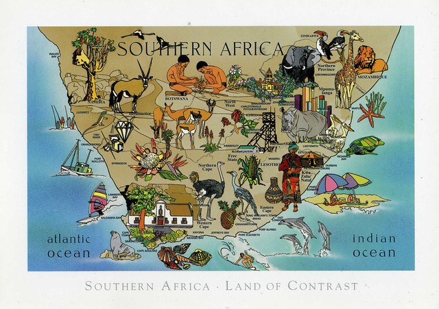
South Africa, officially the Republic of South Africa (RSA), is a country located in Southern Africa. It has 2,798 kilometres of coastline that stretches along the South Atlantic and Indian oceans. To the north lie the neighbouring countries of Namibia, Botswana and Zimbabwe; to the east are Mozambique and Swaziland; and within it lies Lesotho, an enclave surrounded by South African territory. South Africa is the 25th-largest country in the world by land area, and with close to 53 million people, is the world's 25th-most populous nation.

South Africa is a multiethnic society encompassing a wide variety of cultures, languages, and religions. Its pluralistic makeup is reflected in the constitution's recognition of 11 official languages, which is among the highest number of any country in the world. Two of these languages are of European origin: Afrikaans developed from Dutch and serves as the first language of most white and coloured South Africans, based on history. Though English is commonly used in public and commercial life, it is fourth-ranked as a spoken first language.

About 80 percent of South Africans are of black sub-Saharan African ancestry, divided among a variety of ethnic groups speaking different Bantu languages, nine of which have official status. The remaining population consists of Africa's largest communities of European (white), Asian (Indian), and multiracial (coloured) ancestry. Since 1994, all ethnic and linguistic groups have had political representation in the country's constitutional democracy, which comprises a parliamentary republic and nine provinces. South Africa is often referred to as the "Rainbow Nation," a term coined by Archbishop Desmond Tutu and later adopted by then-President Nelson Mandela as a metaphor to describe the country's newly developing multicultural diversity in the wake of segregationist apartheid ideology.

The country is one of the few in Africa never to have had a coup d'état, and regular elections have been held for almost a century. But the vast majority of black South Africans were not enfranchised until 1994. During the 20th century, the black majority sought to recover its rights from the dominant white minority, with this struggle playing a large role in the country's recent history and politics. The National Party imposed apartheid in 1948, institutionalizing previous racial segregation. After a long and sometimes violent struggle by the African National Congress and other anti-apartheid activists, Discriminatory laws began to be repealed or abolished from 1990 onwards.

South Africa is ranked as an upper-middle income economy by the World Bank, and is considered to be a newly industrialised country. Its economy is the second-largest in Africa, and the 34th-largest in the world. In terms of purchasing power parity, South Africa has the seventh-highest per capita income in Africa. But poverty and inequality remain widespread, with about a quarter of the population unemployed and living on less than US$1.25 a day. Nevertheless, South Africa has been identified as a middle power in international affairs, and maintains significant regional influence.

Saturday, 11 January 2014

Iraq

This is another postcard from the swap I had with Milad in Iraq back in 2010. I've posted about the other card in this blog before. These two cards are still my only ones from Iraq.


There is some writing on the back of the card but it's all in Arabic so I have no idea whether it says something about the places on this card. ..and as a result I'm totally clueless here. Well, not completely - the picture in the bottom left corner looks like it's from Hatra, which also happens to be a Unesco site. :) A large fortified city under the influence of the Parthian Empire and capital of the first Arab Kingdom, Hatra withstood invasions by the Romans in A.D. 116 and 198 thanks to its high, thick walls reinforced by towers. The remains of the city, especially the temples where Hellenistic and Roman architecture blend with Eastern decorative features, attest to the greatness of its civilization.

Milad wrote that Iraq is the cradle of ancient empires and civilizations dated back to 6000 years. I find this really fascinating, and the more recent history of the region very sad. Hopefully things will improve there.

Sunday, 4 August 2013

Crown Mine, Botallack, England

My collection of UK Unesco sites is still fairly small... this official I received back in 2010 was a nice addition, and one of the more difficult sites to get over here I think.

 
GB-121492
 
Crown Mine in Botallack, Cornwall is part of the Cornwall and West Devon Mining Landscape. Botallack mine was first worked for its tin and copper in 1721, and for a long time was extremely profitable. Its galleries run beneath the sea for a third of a mile from the shore, and the deepest is 1,200 feet below high water. It is no longer worked.

Much of the landscape of Cornwall and West Devon was transformed in the 18th and early 19th centuries as a result of the rapid growth of pioneering copper and tin mining. Its deep underground mines, engine houses, foundries, new towns, smallholdings, ports and harbours, and their ancillary industries together reflect prolific innovation which, in the early 19th century, enabled the region to produce two-thirds of the world’s supply of copper. The substantial remains are a testimony to the contribution Cornwall and West Devon made to the Industrial Revolution in the rest of Britain and to the fundamental influence the area had on the mining world at large. Cornish technology embodied in engines, engine houses and mining equipment was exported around the world. Cornwall and West Devon were the heartland from which mining technology rapidly spread. (from the Unesco website)
 

Saturday, 5 February 2011

Lighthouses, Belgium

I just realised that I haven't posted any postcards from Belgium in this blog yet. ...and it's not THAT rare a country, even if I don't receive postcards from there all the time. Well, this is remedied now with this nice official that arrived a while ago. This might well be my first Belgian lighthouse postcard, actually. :)


BE-80994


These lighthouses are all located in West Flanders, the westernmost province of the Flemish Region, also named Flanders, in Belgium. It borders (clockwise from the North) on the Netherlands, the Flemish province of East Flanders and the Walloon province of Hainaut in Belgium, on France, and the North Sea. Its capital is Bruges (Brugge). Other important cities are Kortrijk in the south and Ostend along the coastline. The province has an area of 3,125 km² which is divided into eight administrative districts containing 64 municipalities.


The stamp is from a set of two Christmas stamps issued in 2010.

Saturday, 22 January 2011

Dominican Republic

One more card for today, a map card of the Dominican Republic.


The Dominican Republic is divided into thirty–one provincias (provinces; singular provincia), while the national capital, Santo Domingo, is contained within its own Distrito Nacional ("National District"). The division of the country into provinces is laid down in the constitution and enacted by law. The latter is currently Law 5220 on the Territorial Division of the Dominican Republic, issued 1959 and frequently amended to create new provinces and lower–level administrative units.

The provinces are the first–level administrative subdivisions of the country. The headquarters of the central government's regional offices are normally found in the capital cities of provinces. The president appoints an administrative governor for each province but not for the Distrito Nacional. The provinces are divided into municipalities (municipios), which are the second–level political and administrative subdivisions of the country.


What makes this card so interesting is that it was actually mailed from Haiti! There's no actual stamp but you should be able to read the cancellation. It took this card almost three months to arrive, but to be honest, I'm surprised it arrived at all, considering all the problems and issues Haiti has been having (and still has). I do hope things will get better there soon.

tea pause

I must have already mentioned that I love tea, so it's probably quite obvious that I collect tea-related postcards. This card had been in my favourites for a while, and I recently received it as a complete surprise from a very nice postcrosser, Liisa, in Finland. Thank you so much, this is a real treat (also because of the stamps, but more about those later)!


I've been drinking even more tea lately as I've been working on that big translation assignment, and I don't seem to be able to translate without tea. :P I tend to have stronger black teas in the morning and earlier on in the day, and when it gets later I often switch to green or white tea. It's probably more a mental thing but I do need black tea in the mornings, I just don't consider myself as having properly waken up without it. ...and even when I don't have many breaks during translating, at least I have to take short breaks to make myself more tea. :)


...and here is why this card is even more special - it was mailed from Åland! I honestly have no idea how Liisa does this or how she got me a special Christmas cancellation so many days AFTER Christmas, but I'm very impressed. And she used the Inge Löök Christmas stamp!! The stamp next to it is from a set of 3 stamps issued in 2004, depicting animals. This one here is the Stoat. The stamp underneath is from a set of 2 stamps issued in 2002, representing Batrachians and Reptiles. This one shows the Smooth snake.

Thursday, 20 January 2011

Prince Edward Island, Canada

My cards for today are a bit of a mixed batch... but I don't always need a theme, do I?


Prince Edward Island is a Canadian province consisting of an island of the same name, as well as other islands. The maritime province is the smallest in the nation in both land area and population (excluding the territories). According to the 2009 estimates, Prince Edward Island has 141,000 residents.

The island's landscape is pastoral. Rolling hills, woods, reddish white sand beaches, ocean coves and the famous red soil have given Prince Edward Island a reputation as a province of outstanding natural beauty. The provincial government has enacted laws that attempt to preserve the landscape through regulation, although the lack of consistent enforcement and absence of province-wide zoning and land-use planning recently resulted in aesthetically displeasing development.

The island's lush landscape has a strong bearing on its economy and culture. Author Lucy Maud Montgomery drew inspiration from the land during the late Victorian Era for the setting of her classic novel Anne of Green Gables. Today, many of the same qualities that Montgomery and others found in the island are enjoyed by tourists who visit year-round. They enjoy a variety of leisure activities, including beaches, various golf courses, eco-tourism adventures, touring the countryside, and enjoying cultural events in local communities around the island.

I have to confess my interest to Prince Edward Island comes mostly from Anne of Green Gables... I haven't read it before but I recently bought the first book in the series (I love the 1p secondhand books on Amazon.co.uk!) and hope to read it soon. Emma, who sent me this card, also sent me an Anne postcard amongst all the other cards. :)

On this card you can see the Confederation Bridge (on the top) and Park Corner Fields (bottom), and on the bottom right corner you can see the Cap-Egmont Lighthouse.


The card came in an envelope - with many, many gorgeous stamps! The large stamp in the middle is from a set of 2 stamps issued in 2005, depicting Mammals. The stamps on the right are from a set of 5 stamps issued in 2007, depicting Insects. The Queen Elizabeth stamp in the middle is a definitive from 2009, and the stamps on the left are from a set of 5 stamps issued in 2010, showing Insects (again).

Skopje, Macedonia

I have a thing for panoramic postcards, there's something quite special about them I think. More room for the picture for one thing, but it's not just that, I can't quite explain it though. One thing is for sure - they are nice to send to friends because there's a bit more room for the writing! :D Anyway, this lovely panoramic card is from the lovely Ana in Macedonia. Thank you so much!


The Orthodox Cathedral Church on this card is situated in the centre of Skopje and is where the main religious events take place, particularly during Christmas and Easter. Oh, and incidentally, Eastern Orthodox national churches celebrate Christmas on 7th January, something I only learned since joining Postcrossing... This really is an educational hobby! :)

It looks like it is The Church of Saint Clement of Ohrid. Built in 1972, the Orthodox church in one of few in the world to be designed in modern contemporary architecture. The main Macedonian orthodox cathedral church was consecrated in 1990, on the 1150th anniversary of the birth of the church patron, St. Clement of Ohrid. The iconostasis icons were painted by Gjorgi Danevski and Spase Spirovski and the frescoes were painted by the academic painter Jovan Petrov and his collaborators.


The stamp is from a set of 4 commemorative stamps issued in 1999 with the theme Flowers.

Wednesday, 5 January 2011

Hua Hin Railway Station, Thailand

My last card for today was sent to me by my grandma last year. She's actually in Thailand at the moment again, staying there for a while. She told me she needed to go somewhere warm and apparently Thailand is one of the only places where you get guaranteed sunshine. :D (That, and it's not overly expensive over there. I don't think grandma could afford the Caribbean...) So yeah, I might have another postcard coming from Thailand soon. :)


The Hua Hin Railway Station is one of the oldest railway stations in Thailand. Its most striking feature is the unique Royal Waiting Room in Thai architectural style. The Royal Waiting Room was built in the reign of King Rama VI in order to welcome the King and his entourage. The outstanding feature of the station is the pavilion constructed in in the reign of King Rama VI; it was originally named as "Plub Pla Sanamchan", and it was initially situated at Sanacham Palace in Nakorn Pathom Province. The Royal Waiting Room, the original building built in the same architectural style as Maruekkhathayawan Palace, stands adjacent to the station, and is a favourite spot for taking pictures for both Thai and foreign tourists. [source]


The smaller stamp is from a set of 6 "Greetings" stamps issued in 2010. The bigger stamp is from a miniature sheet of 12 stamps issued in 2008, with the subject Chatukham Rammathep.

Georgetown, Penang, Malaysia

This card is from a swap with SL Liew in Malaysia. I just love the colourful rooftops here!


Georgetown is the capital of the state of Penang in Malaysia. Named after Britain's King George III, Georgetown is located on the north-east corner of Penang Island and has about 220,000 inhabitants, or about 400,000 including the suburbs. The inner city of Georgetown is a UNESCO World Heritage Site.

Georgetown has the largest concentration of pre-war terracotta rooftop double storey terrace houses which are shops on the ground floor, with air wells and residential on top floor. Due to rent control after war set by the British administration, there was no urban renewal, thus indirectly preserving them. The rent control was repealed a decade ago.


The stamp is from a set of 3 stamps issued in 2009, depicting palm trees.

The Peak Tram, Hong Kong

This card is from a swap with a very nice postcrosser, but it reminds me more of friends. One of my best friends here in England is from Hong Kong, and she once sent this same card (or at least I think it's the same) to two other friends of ours when she was visiting home, in fact I think they still have the card over their fireplace. ;)


Hong Kong's oldest form of mechanical transport, the Peak Tram opened in 1888. Originally run by steam it converted to electricity in 1926 and then to microprocessor control in 1989. The upper terminus is 397 metres above sea level and the single journey takes 8 minutes from the lower terminus in St John's Building.

Trakai, Lithuania

I seem to be sending quite a lot of official postcrossing cards to Lithuania but haven't received many from there. It's a shame, I'd like to see more of this country!


This card had been in my favourites for a while, and last year I finally got it via a tag on the postcrossing forum. Isn't it a gorgeous view?! It sort of reminds me of Savonlinna where I used to study, except that Trakai looks a little more beautiful. :)

Trakai Island Castle is located in Trakai, Lithuania on an island of Lake Galvė. The castle is sometimes referred to as "Little Marienburg". The construction of the stone castle was begun in the 14th century by Kęstutis, and around 1409 major works were completed by his son Vytautas the Great, who died in this castle in 1430. Trakai was one of the main centers of the Grand Duchy of Lithuania and the castle held great strategic importance.

Vladivostok, Russia

I thought I'd post a few older cards for a change. I've got so many nice ones I received before starting this blog and it would be a shame to leave them all aside.

I'm starting with this lovely card from Russia I received through a swap. I totally adore it - the old house looks very charming and the black cat just adds to the charm. ...AND the card is from Vladivostok, a place I find fascinating due to its remote location.


Vladivostok is Russia's largest port city on the Pacific Ocean and the administrative center of Primorsky Krai. It is situated at the head of the Golden Horn Bay, not far from Russia's border with China and North Korea. It is the home port of the Russian Pacific Fleet. The population of the city, as of 2010, is 578,000.

From 1958 to 1991, only Soviet citizens were allowed to live in Vladivostok or visit it (and even then had to obtain an official permission). Before this closure, the city had large Korean and Chinese populations. Some Koreans who were deported during Stalin's rule from the Russian Far East have since returned, particularly to Vladivostok.

The Trans-Siberian Railway was built to connect European Russia with Vladivostok, Russia's most important Pacific Ocean port. Finished in 1905, the rail line ran from Moscow to Vladivostok via several of Russia's main cities. Part of the railroad, known as the Chinese Eastern Line, crossed over into Manchuria, China, passing through Harbin, a major city in Manchuria. During the Soviet era, Vladivostok's status as a closed city meant that ferry-passenger tourists arriving from Japan to travel the Trans-Siberian railway westbound had to embark in Nakhodka. Today, Vladivostok serves as the main starting point for the Trans-Siberian portion of the Eurasian Land Bridge.

The picture on this card is from the Old City (Millionka) in Vladivostok. ...and could you have guessed that this is an ad card? I sure couldn't if I didn't know! Just goes to show that there are nice ad cards around so I don't think people should be so negative about all ad cards. (The card advertises a café and Vladivostok TAXI.)

Sunday, 2 January 2011

Galo de Barcelos, Portugal

Most of the cards I got from Wanda for Christmas were from Spain, but there were a few Portuguese ones there as well. This one is probably my favourite.


There is some info at the back of the card:

In the town of Barcelos there is a very famous symbol called o Galo de Barcelos in Portuguese. The legend says that a rich man made a big party. When the party was over, the rich man noticed that his sterling cutlery was stolen by a guest. He accused a pilgrim and let him go to court. He protested his innocence, but the judge didn't believe him. The judge was about to eat a roasted cock and the pilgrim said: If I am innocent, this cock will crow. When the pilgrim was about to be hanged, the cock crowed. The judge released the pilgrim. The story ends and a few years later when the pilgrim returned and made a statue over the event. This legend became famous all over Portugal.

Elche, Spain

One more card from Spain for today. This one's from Elche, in Costa Blanca in Valencia.


Elche is a city located in the comarca of Baix Vinalopó, in the Alicante province which, in turn, is a part of the Valencian Community, Spain. According to the 2008 census, Elche has a population of some 228,300 inhabitants, ranking as the third most populated city in the Valencian Community (after Valencia and Alicante) and the 20th largest Spanish city.

Part of the municipality is coastal but the main city is some 11 km from the Mediterranean Sea. A small creek called Vinalopó flows through the city splitting it in two parts.

El Huerto del Cura ('the Curate's orchard') is part of El Palmeral - an ancient grove of palm trees (Phoenix dactylifera) said to have been planted by the Phoenecians. The orchard grows both fruiting species and ornamental species. The garden has two ponds. [source]

Costa Blanca, Spain

Let's move on, to the west coast of Spain. This is another card I got from Wanda. I'm so excited she got me a map card as well!


Costa Blanca refers to the over 200 kilometres of coastline belonging to the Province of Alicante in Spain. The name "Costa Blanca" was devised as a promotional name used by British European Airways when they launched their air service between London and Valencia in 1957. It has a well developed tourism industry and is a popular destination for British and German tourists. It extends from the towns of Denia in the north, beyond which lies the Costa dels Tarongers, to Pilar de la Horadada in the south, beyond which lies the Costa Calida. It includes the major tourist destinations of Benidorm, Alicante, Denia and Xàbia.

Cíes Islands, Spain

One more Galician card...


The Cíes Islands are an archipelago off the coast of Pontevedra in Galicia, in the mouth of the Ría de Vigo. They belong to the parish of San Francisco de Afora, in the municipality of Vigo. They were declared a Nature Reserve in 1980 and are included in the Atlantic Islands of Galicia National Park (Parque Nacional Marítimo-Terrestre das Illas Atlánticas de Galicia) created in 2002. In the year 2007, the British newspaper The Guardian chose the beach of Rodas, in the island of Monteagudo, as the "most beautiful beach of the world".

The Cíes consist of three islands, Monteagudo ("Sharp Mount" or North Island), do Faro ("Lighthouse Island", or Isla do Medio, "Middle Island") and San Martiño ("Saint Martin" or South Island).

Due to the high natural value of this area and to the deterioration it was suffering by human activity, it was declared a Nature Reserve in 1980. The level of legal protection varied until November 21, 2000, when the Galician Parliament unanimously agreed to apply for the status of National Park to the central Government. The Spanish Congress of Deputies signed a definite agreement in June 2002, creating the National Land-Marine Park of the Atlantic Islands of Galicia, formed by a number of archipelagos, islands and cays, namely the Cíes, Ons, Sálvora, Noro, Vionta, Cortegada and the Malveiras.

Vigo, Spain

More cards from Wanda...


Vigo is a city and municipality in Galicia, Spain. The city is located on the ria of the same name on the Atlantic Ocean.

It is the largest city in Galicia with a population of 297,332, with an extended metropolitan population of 468,654, making it the 14th-largest metropolitan area of Spain. Vigo is the largest city in Spain which is not a provincial capital.

The urban area of Vigo is built over both a hill-fort (Castro) and a Roman settlement. It is generally accepted that the name Vigo is derived from the Latin word Vicus.

Vigo is one of the leading industrial areas in Galicia, with car factories, shipyards, and auxiliary industry. Vigo has the largest fishing port in Europe as well, and the home port of the world's largest fishing company, Pescanova. The headquarters of the European Fisheries Agency are placed in here.

Conxuro da Queimada

Happy New Year 2011! I hope you all will have a lovely year with lots of great postcards. :) 2010 was pretty good for me postcard-wise, I'm hoping 2011 will be the same. I got some Spanish and Portuguese postcards for Christmas from my friend Wanda. Yeah, my friends know I like postcards :D There were some really nice ones amongst those cards so I wanted to post about a few of them here. The first one is a very cool recipe card. :)


'Conxuro da Queimada' translates as 'Queimada's Spell'. It is an alcoholic beverage of Galician tradition. Queimada is a punch made from Galician aguardente (Orujo Gallego) - a spirit distilled from wine and flavoured with special herbs or coffee, plus sugar, lemon peel, coffee beans and cinnamon.

Typically, while preparing the punch a spell or incantation is recited, so that special powers are conferred to the queimada and those drinking it. Then the queimada is set alight, and slowly burns as more brandy is added. Wanda very helpfully included an English translation on the back of the card:

Owls, barn owls, toads and witches. Demons, goblins and devils, spirits of the misty vales.

Crows, salamanders and mages, charms of the folk healer(ess). Rotten pierced canes, home of worms and vermin. Wisps of the Holy Company, evil eye, black witchcraft, scent of the dead, thunder and lightning. Howl of the dog, omen of death, maws of the satyr and foot of the rabbit. Sinful tongue of the bad woman married to an old man.

Satan and Beelzebub's Inferno, fire of the burning corpses, mutilated bodies of the indecent ones, farts of the arses of doom, bellow of the enraged sea.

Useless belly of the unmarried woman, speech of the cats in heat, dirty turf of the wicked born goat.

With this bellows I will pump the flames of this fire which looks like that from Hell, and witches will flee, straddling their brooms, going to bathe in the beach of the thick sands. Hear! Hear the roars of those that cannot stop burning in the firewater, becoming so purified.

And when this beverage goes down our throats, we will get free of the evil of our soul and of any charm. Forces of air, earth, sea and fire, to you I make this call: if it's true that you have more power than people, here and now, make the spirits of the friends who are outside, take part with us in this Queimada.

Thursday, 30 December 2010

Winnipeg, Canada

One more card for today. I really love all the blueness in this card, it creates such a lovely atmosphere!


Winnipeg is the capital and largest city of Manitoba, Canada, and is the primary municipality of the Winnipeg Capital Region, with more than sixty percent of Manitoba's population. Winnipeg is the seventh-largest municipality in Canada, with a population of 633,451 in the Canada 2006 Census.

The name "Winnipeg" comes from the Cree for "muddy waters". The Winnipeg area was a trading centre for Aboriginal peoples prior to the arrival of Europeans. The first fort was built there in 1738 by French traders. A settlement was later founded by the Selkirk settlers in 1812, the nucleus of which was incorporated as the City of Winnipeg in 1873. During the late 19th century and early 20th century, Winnipeg was one of the fastest growing cities in North America. The University of Manitoba, founded during this period, was the first university in Western Canada.

Winnipeg has a diversified economy, with sectors in finance, manufacturing, food and beverage production, culture, retail and tourism. Winnipeg is a major transportation hub, served by Richardson International Airport. The city has railway connections to the United States and Eastern and Western Canada through three Class I rail carriers.

Winnipeg's cultural organizations and festivals include the Royal Winnipeg Ballet, Le Cercle Molière, Festival du Voyageur and Folklorama. Professional sports organizations based in the city include the Winnipeg Blue Bombers, the Winnipeg Goldeyes, and the Manitoba Moose.