Showing posts with label usa. Show all posts

Thursday, 12 July 2018

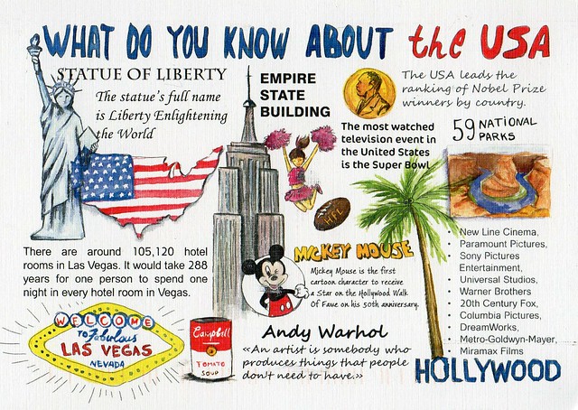
What do you know about the USA

Long time no see... I hadn't realised it's been over a year since my last update. Ooops... I don't think I'll ever catch up with this, as even if I have the time, most of the time I'm not in the mood for doing this.

Anyway... I've started collecting a new postcard series. I wasn't going to, but I think these water colours are really pretty and the cards are really nice. I'm posting this one now mainly because I'll be going to the USA myself later this year. :) I'll be going to Orlando, Florida for 10 days in October and very much looking forward to it, although I'm also a little nervous as I've never been outside of Europe before. It should be interesting, though. I'm not too keen on Disney but I definitely want to visit the Universal Studios - and travel on the Hogwarts Express ;)

This card is from a swap with Julia earlier this year. She added a little bit of information on the back of the card as well, about the Four Corners Monument. It is the only place in the US where four states intersect: Arizona, New Mexico, Utah and Colorado. You can stand on that spot and truly be in four states at one time.

Saturday, 12 September 2015

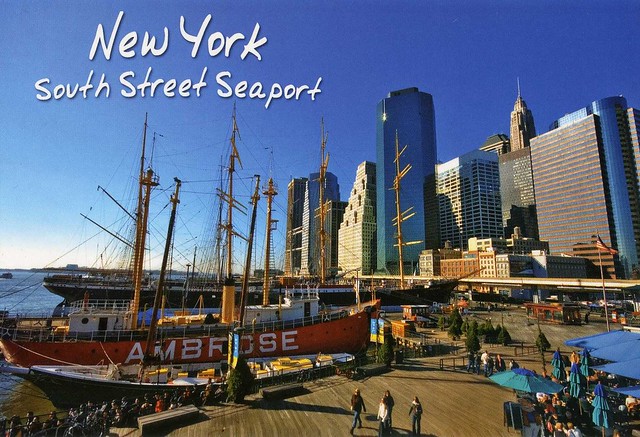
South Street Seaport, New York, USA

I got this postcard from my friend Wanda a few years ago. I really like this postcard, and it's nice to see a slightly different view of New York.


The South Street Seaport is a historic area in the New York City borough of Manhattan, centered where Fulton Street meets the East River, and adjacent to the Financial District. The Seaport is a designated historic district, and is distinct from the neighboring Financial District. It is part of Manhattan Community Board 1 in Lower Manhattan, and is bounded by the Financial District to the west, southwest, and north; the East River to the southeast; and Two Bridges to the northeast.

It features some of the oldest architecture in downtown Manhattan, and includes the largest concentration of restored early 19th-century commercial buildings in the city. This includes renovated original mercantile buildings, renovated sailing ships, the former Fulton Fish Market, and modern tourist malls featuring food, shopping, and nightlife, with a view of the Brooklyn Bridge.

Wednesday, 22 July 2015

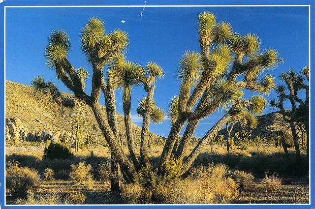
Joshua Tree National Park, USA

I'm getting so behind with this blog. ...and I can't see things improving very soon. I thought I'd update now that I have the time AND inspiration. To be fair, most of the time I'm just not very organised.. :P

Today's first card is from the Vacation RR from earlier this year. I do have a bit of a soft spot for postcards showing national parks.


Joshua Tree National Park is located in southeastern California. Declared a U.S. National Park in 1994 when the U.S. Congress passed the California Desert Protection Act (Public Law 103-433), it had previously been a U.S. National Monument since 1936. It is named for the Joshua trees (Yucca brevifolia) native to the park. It covers a land area of 3,199.59 km2 – an area slightly larger than the state of Rhode Island. A large part of the park, some 173,890 ha, is a designated wilderness area. Straddling the San Bernardino County/Riverside County border, the park includes parts of two deserts, each an ecosystem whose characteristics are determined primarily by elevation: the higher Mojave Desert and lower Colorado Desert. The Little San Bernardino Mountains run through the southwest edge of the park.

Monday, 1 June 2015

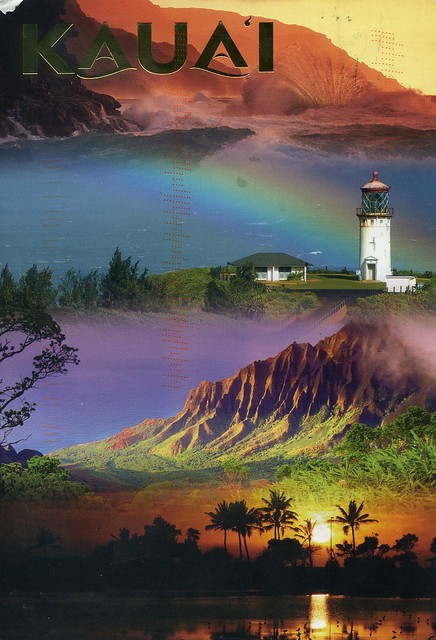
Kaua'i, Hawaii, USA

A postcard I received through an Instagram swap a couple of years ago. Hawaii looks so dreamy!


Kauaʻi is geologically the oldest of the main Hawaiian Islands. With an area of 1,456.4 km2, it is the fourth largest of the main islands in the Hawaiian archipelago, and the 21st largest island in the United States. Known also as the "Garden Isle", Kauaʻi lies 169 km across the Kauaʻi Channel, northwest of Oʻahu. This island is the site of Waimea Canyon State Park.

The United States Census Bureau defines Kauaʻi as Census Tracts 401 through 409 of Kauaʻi County, Hawaiʻi, which is all of the county except for the islands of Kaʻula, Lehua, and Niʻihau. The 2010 census population of Kauaʻi (the island) was 67,091, with the largest town by population being Kapaʻa.

Wednesday, 22 April 2015

Napa Valley, California, USA

A lovely springtime view from the USA I received last year from a Year of the Horse stamp swap. Just look at the colours here!


Napa Valley AVA is an American Viticultural Area located in Napa County, California, United States. Napa Valley is considered one of the premier wine regions in the world. Records of commercial wine production in the region date back to the nineteenth century, but premium wine production dates back only to the 1960s.

The combination of Mediterranean climate, geography and geology of the region are conducive to growing quality wine grapes. John Patchett established the Napa Valley's first commercial vineyard in 1858. In 1861 Charles Krug established another of Napa Valley's first commercial wineries in St. Helena. Viticulture in Napa suffered several setbacks in the late 19th and early 20th centuries, including an outbreak of the vine disease phylloxera, the institution of Prohibition, and the Great Depression. The wine industry in Napa Valley recovered, and helped by the results of the Paris Wine Tasting of 1976, came to be seen as capable of producing the best quality wine – equal to that of Old World wine regions. Napa Valley is now a major enotourism destination.

Wednesday, 15 April 2015

Greetings from the USA

One more card for today, another 'Greetings from' one. I've actually received a few of the new countries already but I thought I'd post the older ones here first.


It must have been really difficult to choose the 'famous Americans' for this one as there are so many. ...which is why it's a bit weird that Pocahontas is included. As the sender points out, she's more of a famous legend than a famous American.

 ...also, I guess technically you could say this is a Unesco card as well as the Statue of Liberty is a Unesco site..?! :D

Monday, 13 April 2015

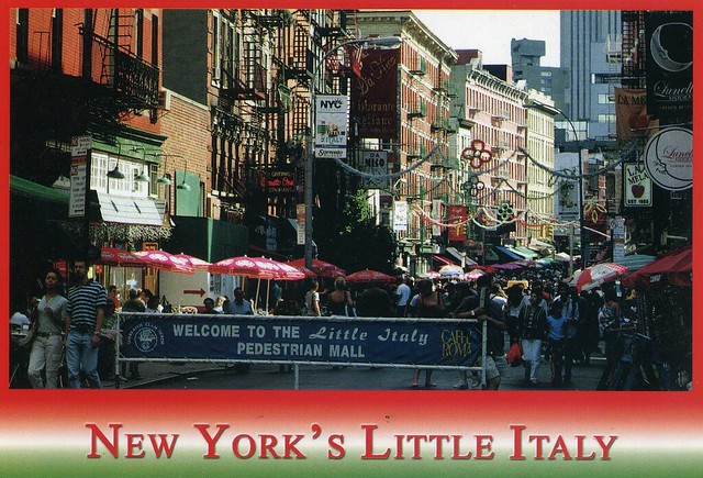
New York's Little Italy, USA

I got some New York postcards from Wanda a few years ago. This is one of them. I really like street views like this!


Little Italy is a neighborhood in lower Manhattan, New York City, once known for its large population of Italians. Today the neighborhood consists of only a few Italian stores and restaurants. It is bounded on the west by Tribeca and Soho, on the south by Chinatown, on the east by the Bowery and Lower East Side, and on the north by Nolita.

 Little Italy on Mulberry Street used to extend as far south as Worth Street, as far north as Kenmare Street, as far west as Lafayette Street, and as far east as Bowery. It is now only three blocks on Mulberry Street.

As of the 2000 U.S. Census, 1,211 residents claiming Italian ancestry lived in three census tracts that make up Little Italy. Those residents comprise 8.25% of the population in the community, which is similar to the proportion of those of Italian ancestry throughout New York City.

Wednesday, 8 April 2015

Santuario, Risaralda, Colombia

I wonder if I'll ever manage to get a written and stamped postcard from Colombia... This one was sent from the US. I just love the colours here, such a lovely-looking place!


This is Calle Rial in Santuario, a town and municipality in the Department of Risaralda, Colombia.

Risaralda Department is located in the western central region of the country and part of the Paisa Region. Its capital is Pereira. It was divided from the department of Caldas in 1966. Risaralda is very well known for the high quality of its coffee, and a booming industry: clothes, food, trading of goods, and services.

The territory is very mountainous and has many kinds of climates in a very small area. Its proximity to harbours such as Buenaventura on the Pacific Ocean and to the biggest cities in Colombia – Bogotá, Cali, Medellín – makes it a fast-growing economic centre.

Sunday, 5 April 2015

Everglades National Park, Florida, USA

I received a couple of different postcards of Everglades National Park a couple of years ago from swaps with two different people. The first one here came with a bunch of other US Unesco cards and the second one is written and stamped.


Everglades National Park is a U.S. National Park in Florida that protects the southern 20 percent of the original Everglades. In the United States, it is the largest tropical wilderness, the largest wilderness of any kind east of the Mississippi River, and is visited on average by one million people each year. It is the third-largest national park in the lower 48 states after Death Valley and Yellowstone. It has been declared an International Biosphere Reserve, a World Heritage Site, and a Wetland of International Importance, one of only three locations in the world to appear on all three lists.


Although most U.S. national parks preserve unique geographic features, Everglades National Park was the first created to protect a fragile ecosystem. The Everglades are a network of wetlands and forests fed by a river flowing 0.40 km per day out of Lake Okeechobee, southwest into Florida Bay. The Park is the most significant breeding ground for tropical wading birds in North America, contains the largest mangrove ecosystem in the western hemisphere, is home to 36 threatened or protected species including the Florida panther, the American crocodile, and the West Indian manatee, and supports 350 species of birds, 300 species of fresh and saltwater fish, 40 species of mammals, and 50 species of reptiles. The majority of South Florida's fresh water, which is stored in the Biscayne Aquifer, is recharged in the park.

Humans have lived for thousands of years in or around the Everglades, until plans arose in 1882 to drain the wetlands and develop the recovered land for agricultural and residential use. As the 20th century progressed, water flow from Lake Okeechobee was increasingly controlled and diverted to enable explosive growth of the South Florida metropolitan area. The park was established in 1934 to protect the quickly vanishing Everglades, and dedicated in 1947 as massive canal building projects were initiated across South Florida. The ecosystems in Everglades National Park have suffered significantly from human activity, and restoration of the Everglades is a politically charged issue in South Florida.


Friday, 3 April 2015

animals of Costa Rica

This is an official I received almost six years ago. I thought it was really sweet of the sender to send this to me from her trip to Costa Rica. I certainly don't mind the country ID not matching the picture or the stamps. ;)

 
US-395952
 
I do hope I got the species right here... This is what a quick google search and Wikipedia gave me:

The white-headed capuchin (Cebus capucinus), also known as the white-faced capuchin or white-throated capuchin, is a medium-sized New World monkey of the family Cebidae, subfamily Cebinae. Native to the forests of Central America and the extreme north-western portion of South America, the white-headed capuchin is important to rainforest ecology for its role in dispersing seeds and pollen.

The Central American squirrel monkey (Saimiri oerstedii) is a squirrel monkey species from the Pacific coast of Costa Rica and Panama. It is restricted to the northwestern tip of Panama near the border with Costa Rica, and the central and southern Pacific coast of Costa Rica, primarily in Manuel Antonio and Corcovado National Parks.

Spider monkeys of the genus Ateles are New World monkeys in the subfamily Atelinae, family Atelidae. Like other atelines, they are found in tropical forests of Central and South America, from southern Mexico to Brazil. The genus contains seven species, all of which are under threat; the black-headed spider monkey, and brown spider monkey are critically endangered.

The mantled howler (Alouatta palliata), or golden-mantled howling monkey, is a species of howler monkey, a type of New World monkey, from Central and South America. It is one of the monkey species most often seen and heard in the wild in Central America. It takes its "mantled" name from the long guard hairs on its sides.

Delaware state map, USA

I should really start posting more US state maps here, especially now that I finally have all the states! ;) Here's Delaware, received a few years ago.


Delaware is a state located in the Northeast megalopolis region and the Northeastern region of the United States. It is bordered to the south and west by Maryland, to the northeast by New Jersey, and to the north by Pennsylvania. The state takes its name from Thomas West, 3rd Baron De La Warr, an English nobleman and Virginia's first colonial governor, after whom what is now called Cape Henlopen was originally named.

Delaware is in the northeastern portion of the Delmarva Peninsula and is the second smallest, the sixth least populous, but the sixth most densely populated of the 50 United States. Delaware is divided into three counties, the lowest number of counties of any state. From north to south, the three counties are New Castle, Kent, and Sussex. While the southern two counties have historically been predominantly agricultural, New Castle County has been more industrialized.

Before its coastline was explored by Europeans in the 16th century, Delaware was inhabited by several groups of American Indians, including the Lenape in the north and Nanticoke in the south. It was initially colonized by Dutch traders at Zwaanendael, near the present town of Lewes, in 1631. Delaware was one of the 13 colonies participating in the American Revolution and on December 7, 1787, became the first state to ratify the Constitution of the United States, thereby becoming known as The First State.

Sunday, 22 March 2015

a tiny post office, North Carolina, USA

This is a slightly older card, received six year ago as an official. I'd been meaning to post it here for ages but something was always playing up with Flickr when I tried. Well, here it is now.

 
US-356730
 
What a cute little post office! It's located in Salvo in North Carolina, USA. The sender told me that it looks more like a child's playhouse and the post mistress is an elderly lady.

Salvo is a census-designated place located in Dare County, North Carolina, on Hatteras Island, part of North Carolina's Outer Banks. Originally (with Rodanthe and Waves) part of the settlement of Chicamacomico, Salvo was originally known as Clarks or Clarksville.

The name "Salvo" allegedly stems from the American Civil War, during which a passing Union vessel spotted the settlement, which was not marked on their maps. The commanding officer ordered an attack, and a sailor marked the site on his map with the word "Salvo." The name was formally given to the town when it received a post office in 1901. The Salvo post office, zip code 27972, one of the smallest postal facilities in the United States, was damaged by an arsonist in 1992. A new post office was constructed later in the decade for all of Chicamacomico. Hurricane Sandy in October 2012 damaged much of the Outer Banks area including Salvo.

Monday, 16 March 2015

Wisconsin map, USA

For a few years I thought I had completed my US state map postcard collection and thought that when I finally managed to get North Dakota, I was done. I was going through my albums on Flickr the other day, though, and realised I didn't have a map card of Wisconsin. How did that happen?? Well, now my collection really should be complete. :P

I used to have a penpal in Wisconsin years and years ago but sadly we've pretty much lost touch since. Well, she's on Facebook but I'm pretty rubbish at keeping up to date with my friends' pages there. I do miss her letters but life sometimes gets in the way and things happen.


Wisconsin is a U.S. state located in the north-central United States, in the Midwest and Great Lakes regions. It is bordered by Minnesota to the west, Iowa to the southwest, Illinois to the south, Lake Michigan to the east, Michigan to the northeast, and Lake Superior to the north. Wisconsin is the 23rd state by total area and the 20th most populous. The state capital is Madison, and its largest city is Milwaukee, which is located on the western shore of Lake Michigan. The state comprises 72 counties.

Wisconsin's geography is diverse, with the Northern Highland and Western Upland along with a part of the Central Plain occupying the western part of the state and lowlands stretching to the shore of Lake Michigan. Wisconsin is second to Michigan in the length of its Great Lakes coastline.

Wisconsin is known as "America's Dairyland" because it is one of the nation's leading dairy producers, particularly famous for cheese. Manufacturing, especially paper products, information technology (IT), and tourism are also major contributors to the state's economy.

Saturday, 21 February 2015

Amish Country, USA

I seem to remember there was a documentary series on TV here last (?) year about the Amish. I didn't watch too much of it but I did find it kind of interesting. I've got a couple of postcards about the Amish, one an official and one that I received as part of a swap so I thought I'd include them both here. The first one is from Pennsylvania and the second one from Indiana.

 
US-194987

The Amish are a group of traditionalist Christian church fellowships, closely related to but distinct from Mennonite churches, with whom they share Swiss Anabaptist origins. The Amish are known for simple living, plain dress, and reluctance to adopt many conveniences of modern technology. The history of the Amish church began with a schism in Switzerland within a group of Swiss and Alsatian Anabaptists in 1693 led by Jakob Ammann. Those who followed Ammann became known as Amish.

 In the early 18th century, many Amish and Mennonites immigrated to Pennsylvania for a variety of reasons. Today, the most traditional descendants of the Amish continue to speak Pennsylvania German, also known as "Pennsylvania Dutch". However, a dialect of Swiss German predominates in some Old Order Amish communities, especially in the American state of Indiana. As of 2000, over 165,000 Old Order Amish live in the United States and about 1,500 live in Canada. A 2008 study suggested their numbers have increased to 227,000, and in 2010 a study suggested their population had grown by 10 percent in the past two years to 249,000, with increasing movement to the West.

Amish church membership begins with baptism, usually between the ages of 16 and 25. It is a requirement for marriage, and once a person has affiliated with the church, he or she may marry only within the faith. Church districts average between 20 and 40 families, and worship services are held every other Sunday in a member's home. The district is led by a bishop and several ministers and deacons. The rules of the church, the Ordnung, must be observed by every member and cover most aspects of day-to-day living, including prohibitions or limitations on the use of power-line electricity, telephones, and automobiles, as well as regulations on clothing. Most Amish do not buy commercial insurance or participate in Social Security. As present-day Anabaptists, Amish church members practice nonresistance and will not perform any type of military service.


Amish children in straw hats and bonnets are a common sight during school days in Northern Indiana Amish Country. One room Amish schoolhouses dot the countryside along the 90-mile Heritage Trail audio tour route.

Friday, 20 February 2015

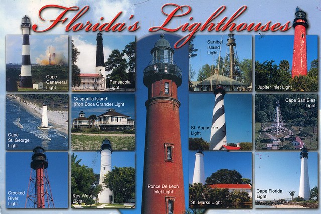
lighthouses of Florida, USA

I'm not normally too keen on receiving a viewcard from one country with stamps from another country. I didn't mind at all when I found this lovely treat in my mailbox about a year ago, however. I wouldn't normally post the back of a postcard here but I just HAVE to make an exception for this one, it's gorgeous and so creative! The sender, Andrea, actually featured in the Postcrossing blog spotlight a few months ago, with very good reason. Do read the interview, it's very inspiring!

 
CA-408911
  
I'm not sure if I already had this card in my collection... but I really don't mind! Ahhhh, and to be somewhere like Florida right now... *dreams*


So yes, the highlight of this card for me is definitely the back. So many beautiful stamps and lovely little details!

Sunday, 17 August 2014

Hawaii

A wonderful map card I received as part of a swap last year.


Hawaii is the 50th and most recent U.S. state to join the United States. It joined the Union on August 21, 1959. It is the only U.S. state located in Oceania and the only one made up entirely of islands. It is the northernmost island group in Polynesia, occupying most of an archipelago in the central Pacific Ocean.

Hawaii’s diverse natural scenery, warm tropical climate, abundance of public beaches, oceanic surroundings, and active volcanoes make it a popular destination for tourists, (wind) surfers, biologists, and volcanologists alike. Due to its mid-Pacific location, Hawaii has many North American and Asian influences along with its own vibrant native culture. Hawaii has over a million permanent residents, along with many visitors and U.S. military personnel. Its capital is Honolulu on the island of Oʻahu.

The state encompasses nearly the entire volcanic Hawaiian Archipelago, which comprises hundreds of islands spread over 2,400 km. At the southeastern end of the archipelago, the eight "main islands" are (from the northwest to southeast) Niʻihau, Kauaʻi, Oʻahu, Molokaʻi, Lānaʻi, Kahoʻolawe, Maui and the Island of Hawaiʻi. The last is the largest and is often called the "Big Island" to avoid confusing the island with the state or archipelago. The archipelago is physiographically and ethnologically part of the Polynesian subregion of Oceania.

 Hawaii is the 8th smallest, the 11th least populous, but the 13th most densely populated of the 50 U.S. states. Hawaii's ocean coastline is about 1,210 km long, which is fourth in the United States after those of Alaska, Florida and California. Hawaii is the only U.S. state not located in the Americas and the only state with an Asian plurality. It and Arizona are the only two states that do not observe daylight saving time, and Hawaii and Alaska are the only two states that are not in the contiguous United States.

Saturday, 14 December 2013

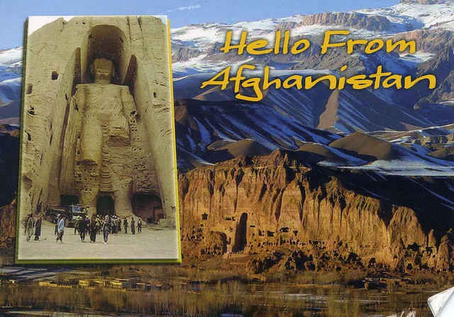
Afghanistan

Yeah, just a couple of cards again for today. This one's pretty special as well, my first postcard from Afghanistan, although not mailed using Afghan stamps but mailed from a US army base. Still, I'm really happy to have this one in my collection, and it's a Unesco card as well! :) Thank you so much for the swap, Jon!


Afghanistan, officially the Islamic Republic of Afghanistan, is a landlocked sovereign state forming part of South Asia, Central Asia, and to some extent Western Asia. It has a population of around 30 million inhabiting an area of approximately 647,500 km2, making it the 42nd most populous and 41st largest nation in the world. It is bordered by Pakistan in the south and the east, Iran in the west, Turkmenistan, Uzbekistan, and Tajikistan in the north, and China in the far northeast.

Afghanistan has been an ancient focal point of the Silk Road and human migration. Archaeologists have found evidence of human habitation from as far back as the Middle Paleolithic. Urban civilization may have begun in the area as early as 3,000 to 2,000 BC. Sitting at an important geostrategic location that connects the Middle East culture with Central Asia and the Indian subcontinent, the land has been home to various peoples through the ages and witnessed many military campaigns, notably by Alexander the Great, Arab Muslims, Genghis Khan, and in modern era Western forces. The land also served as a source from which the Kushans, Hephthalites, Samanids, Ghaznavids, Ghorids, Mughals, Durranis and others have risen to form major empires.

The political history of the modern state of Afghanistan begins in 1709 with the rise of the Pashtuns, when the Hotaki dynasty was established in Kandahar followed by the rise of the Durrani Empire in 1747. In the late 19th century, Afghanistan became a buffer state in the "Great Game" between British India and the Russian Empire. Following the 1919 Anglo-Afghan War, King Amanullah began a European style modernization of the country but was stopped by ultra-conservatives. During the Cold War, after the withdrawal of the British from neighboring India in 1947, the United States and the Soviet Union began spreading influences in Afghanistan, which led in 1979 to a bloody war between the US-backed mujahideen forces and the Soviet-backed Afghan government in which over a million Afghans lost their lives. This was followed by a 1990s civil war, the rise and fall of the extremist Taliban government, and the 2001–present war. In December 2001, the United Nations Security Council authorized the creation of the International Security Assistance Force (ISAF) to help maintain security in Afghanistan and assist the Karzai administration.

 Three decades of war made Afghanistan one of the world's most dangerous countries. While the international community is rebuilding war-torn Afghanistan, terrorist groups such as the Haqqani Network and Hezbi Islami are actively involved in a nationwide Taliban-led insurgency, which includes hundreds of assassinations and suicide attacks. According to the United Nations, the insurgents were responsible for 80% of civilian casualties in 2011 and 2012.

As for this postcard, it shows the Cultural Landscape and Archaeological Remains of the Bamiyan Valley. Ignoring an international outcry, the Taliban began demolishing statues across the country in 2001, including two towering ancient stone Buddhas. Militiamen virtually destroyed the almost 2,000-year-old Buddhist masterpieces in the central province of Bamiyan, including the world's tallest standing Buddha measuring 50 metres.
Sunday, 7 July 2013

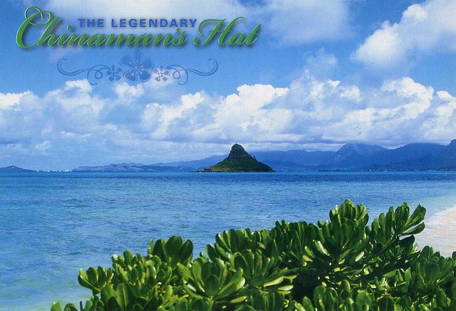
Chinaman's Hat, Hawaii, USA

This postcard is in the minority in my collection as it wasn't received through Postcrossing - and not even through Facebook! I've been in touch with Anne in Hawaii, swapping zines, stickers and tea, and once I asked her if she had any spare postcards she could send me (I don't have too many from Hawaii and it looks so beautiful there). She did ;) This is one of them, one of my favourites, although it was difficult to pick just one as they are all so beautiful.


Mokoliʻi is a 5.1 ha, 63 m tall basalt island 0.54 km offshore of Kualoa Point, Oahu, in Kāne'ohe Bay, Hawaii. Geologically, it used to be connected to Oahu before erosion cut it off. It is also known as "Chinaman's Hat" for its likeness to the straw hats Chinese immigrants wore. Wedge-tailed Shearwaters are the only species of bird that nests here; previously there were a few.

Mokoliʻi is open to the public from dawn to dusk. On weekends it is somewhat a popular secret with tourists and locals. It can be accessed by kayak, boat, surfboard, or by swimming; depth soundings are only four feet on its west side. This may be dangerous during any other time or inclement weather. The area is home to stonefish, and sharks are often seen around the island, often in early mornings.

Saturday, 29 June 2013

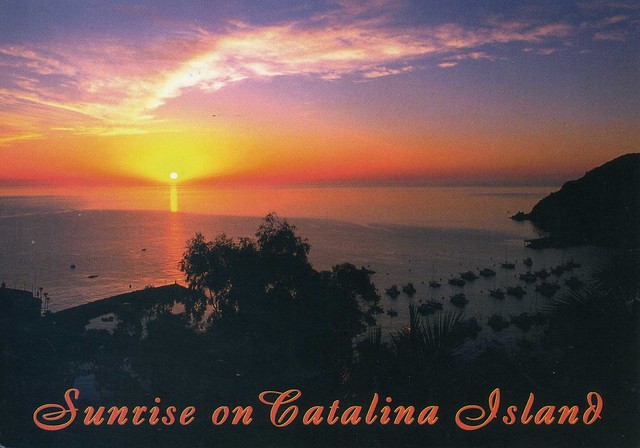
Catalina Island, California, USA

I realised I had two postcards showing Catalina Island in California, USA, so why not have them both in the same post?


The first card, above, is from a facebook swap with Abran last year, while the second card below is an official I received in 2011.

 
US-1297946

Santa Catalina Island, often called Catalina Island, or just Catalina, is a rocky island off the coast of the U.S. state of California in the Gulf of Santa Catalina. The island is 35 km long and 13 km across at its greatest width. The island is located about 35 km south-southwest of Los Angeles, California. The highest point on the island is 639m Mt. Orizaba. One of the Channel Islands of California archipelago, Catalina lies within Los Angeles County.

Catalina was originally settled by Native Americans who called the island Pimugna or Pimu and referred to themselves as Pimugnans or Pimuvit. The first Europeans to arrive on Catalina claimed it for the Spanish Empire. Over the years, territorial claims to the island transferred to Mexico and then to the United States. During this time, the island was sporadically used for smuggling, otter hunting, and gold-digging, before successfully being developed into a tourist destination by chewing gum magnate William Wrigley, Jr. beginning in the 1920s. Since the 1970s, most of the island has been administered by the Catalina Island Conservancy.
The total population as of the 2010 census was 4,096 persons, 90 percent of whom live in the island's only incorporated city, Avalon. The second center of population is the unincorporated village of Two Harbors at the island's isthmus. Development occurs also at the smaller settlements of Rancho Escondido and Middle Ranch. The remaining population is scattered over the island between the two population centers.


The postcard I received in 2012 has a printed postage label so I'm only showing the stamps on the official card. I love the dog stamps!

Saturday, 20 October 2012

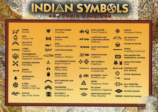
American Indian symbols

A fantastic official card I received from the USA last year. I find this really interesting!

 
US-1346923
 
Info from the back of the card:  

The earliest writings of the American Indians were those of signs and symbols. These symbols are always apparent in their handicraft and jewellery.