Saturday 26 March 2016

Ljubljana, Slovenia

This is such an amazing view, I love this card! Ljubljana looks really idyllic anyway, and then you have this amazing light here. This card had been in my favourites for a while so I was really happy when Nusa offered to swap with me. ...and she used the Slovenian Postcrossing stamp on the card, too!


Ljubljana is the capital and largest city of Slovenia. During antiquity, it was the site of a Roman city called Emona. It was under Habsburg rule from the Middle Ages until the dissolution of the Austro-Hungarian Empire in 1918.

 Situated at the middle of a trade route between the northern Adriatic Sea and the Danube region, it was the historical capital of Carniola, a Slovene-inhabited part of the Habsburg Monarchy, and it has been the cultural, educational, economic, political, and administrative center of independent Slovenia since 1991. Its central geographic location within Slovenia, transport connections, concentration of industry, scientific and research institutions and cultural tradition are contributing factors to its leading position.

The city's architecture is a mix of styles. Despite the appearance of large buildings, especially at the city's edge, Ljubljana's historic center remains intact. Although the oldest architecture has been preserved from the Roman period, Ljubljana's downtown got its outline in the Middle Ages. After the 1511 earthquake, it was rebuilt in the Baroque style following Italian, particularly Venetian, models. After the quake in 1895, it was once again rebuilt, this time in the Vienna Secession style, which today is juxtaposed against the earlier Baroque style buildings that remain. Large sectors built in the inter-war period often include a personal touch by the architects Jože Plečnik and Ivan Vurnik. In the second half of the 20th century, parts of Ljubljana were redesigned by Edvard Ravnikar.

Zaragoza, Spain

A surprise from dear Ana from her travels. :) Thank you so much, it's always so nice to hear from you and I love reading about your journeys! ^_^


Zaragoza, also called Saragossa in English, is the capital city of the Zaragoza province and of the autonomous community of Aragon, Spain. It lies by the Ebro river and its tributaries, the Huerva and the Gállego, roughly in the center of both Aragon and the Ebro basin.

 On 1 September 2010 the population of the city of Zaragoza was 701,090, within its administrative limits on a land area of 1,062.64 square kilometres, ranking fifth in Spain. It is the 32nd most populous municipality in the European Union. The population of the metropolitan area was estimated in 2006 at 783,763 inhabitants. The municipality is home to more than 50 percent of the Aragonese population. The city lies at an elevation of 199 metres above sea level.

 Zaragoza hosted Expo 2008 in the summer of 2008, a world's fair on water and sustainable development. It was also a candidate for the European Capital of Culture in 2012.

The city is famous for its folklore, local gastronomy, and landmarks such as the Basílica del Pilar, La Seo Cathedral and the Aljafería Palace. Together with La Seo and the Aljafería, several other buildings form part of the Mudéjar Architecture of Aragon which is a UNESCO World Heritage Site. The Fiestas del Pilar are among the most celebrated festivals in Spain.

...I feel so stupid for only just having realised that this is (it is, right?!) a Unesco site as well - part of the Mudejar Architecture of Aragon. Just a bit from the Unesco website, then:  

The development in the 12th century of Mudejar art in Aragon resulted from the particular political, social and cultural conditions that prevailed in Spain after the Reconquista. This art, influenced by Islamic tradition, also reflects various contemporary European styles, particularly the Gothic. Present until the early 17th century, it is characterized by an extremely refined and inventive use of brick and glazed tiles in architecture, especially in the belfries. 
 

Bergpark Wilhelmshöhe, Germany

Another Unesco site, this time from Germany. I received two postcards of the same site earlier this year, one from a tag and then shortly after that I received one as an official so I thought I'd include them both here.


This is the first card that I received through a tag on the Postcrossing forum...
 
DE-5057422
 
...and this is the official I then received not long after the first card. It's interesting how the angles are completely different.

Descending a long hill dominated by a giant statue of Hercules, the monumental water displays of Wilhelmshöhe were begun by Landgrave Carl of Hesse-Kassel in 1689 around an east-west axis and were developed further into the 19th century. Reservoirs and channels behind the Hercules Monument supply water to a complex system of hydro-pneumatic devices that supply the site’s large Baroque water theatre, grotto, fountains and 350-metre long Grand Cascade. Beyond this, channels and waterways wind across the axis, feeding a series of dramatic waterfalls and wild rapids, the geyser-like Grand Fountain which leaps 50m high, the lake and secluded ponds that enliven the Romantic garden created in the 18th century by Carl’s great-grandson, Elector Wilhelm I. The great size of the park and its waterworks along with the towering Hercules statue constitute an expression of the ideals of absolutist Monarchy while the ensemble is a remarkable testimony to the aesthetics of the Baroque and Romantic periods.


The stamp on the first card...


...and the second.

Complex of Hué Monuments, Vietnam

A lovely Unesco card from Vietnam I received a couple of years ago.


The Complex of Hue Monuments is located in and around Hue City in Thua Thien-Hue Province in the geographical centre of Vietnam and with easy access to the sea. Established as the capital of unified Vietnam in 1802 CE, Hue was not only the political but also the cultural and religious centre under the Nguyen Dynasty, the last royal dynasty of Vietnamese history, from 1802 to 1945 CE.

The plan of the new capital is in accordance with ancient oriental philosophy, and respected the physical conditions of the site.

The Ngu Binh Mountain (known as the Royal Screen) and the Perfume River, which runs through the city, give this unique feudal capital an entire setting of great natural beauty as well defining its symbolic importance. The site was chosen for a combination of natural features – hills representing a protective screen in front of the monuments or taking the role of “a blue dragon” to the left and “a white tiger” to the right – which shield the main entrance and prevent the entry of malevolent spirits. Within this landscape, the main features of the city are laid out.

The structures of the Complex of Hue Monuments are carefully placed within the natural setting of the site and aligned cosmologically with the Five Cardinal Points (centre, west, east, north, south), the Five Elements (earth, metal, wood, water, fire), and the Five Colours (yellow, white, blue, black, red).

Greetings from Malaysia

Now, I honestly thought I'd already posted about this card in this blog. Turns out I haven't... hhmmmm. I ended up receiving two copies of this card, too, and I'll include the stamps of both of them here as they are both really nice, and one of them has really nice decorations on the back as well. I kind of wish I had that much inspiration when writing my cards!


Matthew points out that Malaysia is the only country that has land on both mainland Asia and Malay archipelago. It does make for a pretty interesting map!

 I also love the bit about multiracial society here. I was talking to my parents in Finland yesterday and some of the things we discussed made me pretty sad. I'd already read some of it in the news and just can't believe some people would be so horrible. Some Finns (and other nationals) could learn a thing or a few from Malaysia!


The stamps on the first card (from Matthew)...


...and the back of the second card. Isn't this lovely?!

Fukuoka, Japan

This is one of those cards again where I'm having slight problems with trying to identify the exact place on the card. ...or the text on the card just confuses me.. :P It says 'Hakata' on the front, but really it's Fukuoka (Hakata is a ward in Fukuoka). Anyway... This card was sent by Susanna, who was staying in Fukuoka as an exchange student last year and earlier this year (I *think* she's back in Finland now??).


Hakata-ku is a ward of the city of Fukuoka in Fukuoka Prefecture, Japan. Many of Fukuoka Prefecture and Fukuoka City's principal government, commercial, retail and entertainment establishments are located in the district. Hakata-ku is also the location of Fukuoka's main train station, Hakata Station, Fukuoka Airport and the Hakata Port international passenger ship terminal.

This card shows Fukuoka Tower among other things. Fukuoka Tower is a 234-metre tall tower located in the Momochihama area of Fukuoka, Japan. It is the tallest seaside tower in Japan. Fukuoka Tower was finished in 1989, taking a total of 14 months to build at a cost of ¥6,000,000,000 (roughly US $50,000,000 in 2015 terms). It was designed by Nikken Sekkei. Fukuoka Tower has three observation decks: one at 116 m, a café/lounge deck at 120 m, and the highest at 123 metres above the ground. The tower also has a triangular cross-section which is covered with 8000 half-mirrors. Because of this, it has been given the nickname "Mirror Sail".

Fukuoka is the capital city of Fukuoka Prefecture and is situated on the northern shore of the island of Kyushu in Japan. It is the most populous city on the island, followed by Kitakyushu. It is the largest city and metropolitan area west of Keihanshin. The city was designated on April 1, 1972, by government ordinance. Greater Fukuoka, with 2.5 million people (2005 census), is part of the heavily industrialized Fukuoka–Kitakyushu zone as well as Northern Kyushu.

As of July 2011, Fukuoka is Japan's sixth largest city, having passed the population of Kyoto. Since the founding of Kyoto in 794, this marks the first time that a city west of the Kinki region has a larger population than Kyoto. In ancient times, however, the area near Fukuoka, the Chikushi region, was thought by some historians to have possibly been even more influential than the Yamato region.

Thursday 24 March 2016

Tusi Sites, China

Tusi Sites is the most recent Unesco site in China. I received this postcard from a swap last year.


Distributed around the mountainous areas of south-west China are the remains of tribal domains whose leaders were appointed by the central government as ‘Tusi’, hereditary rulers of their regions from the 13th to the early 20th century. This system of administrative government was aimed at unifying national administration while simultaneously allowing ethnic minorities to retain their customs and way of life. The three sites of Laosicheng, Tangya and the Hailongtun Fortress combine as a serial property to represent this system of governance. The archaeological sites and standing remains of Laosicheng Tusi Domain and Hailongtun Fortress represent domains of highest ranking Tusi; the Memorial Archway and remains of the Administration Area, boundary walls, drainage ditches and tombs at Tangya Tusi Domain represent the domain of a lower ranked Tusi. Their combinations of local ethnic and central Chinese features exhibit an interchange of values and testify to imperial Chinese administrative methods, while retaining their association with the living cultural traditions of the ethnic minority groups represented by the cultural traditions and practices of the Tujia communities at Laosicheng.

Greetings from Croatia

Today's 'Greetings from' card comes from Croatia. I really like this one, the shades of blue are gorgeous, and I love the colour contrasts here. Also, is that Dubrovnik in the picture?! I only just realised I haven't written about Dubrovnik in this blog before... How did that happen?! I have plenty of postcards from there so will have to fix that.


Dubrovnik is a Croatian city on the Adriatic Sea, in the region of Dalmatia. It is one of the most prominent tourist destinations in the Mediterranean Sea, a seaport and the centre of Dubrovnik-Neretva County. Its total population is 42,615 (census 2011). In 1979, the city of Dubrovnik joined the UNESCO list of World Heritage Sites.

The prosperity of the city was historically based on maritime trade; as the capital of the maritime Republic of Ragusa, it achieved a high level of development, particularly during the 15th and 16th centuries, as it became notable for its wealth and skilled diplomacy.

 The beginning of modern tourism is associated with the construction of the Hotel Imperial in Dubrovnik in 1897. According to CNNGo, Dubrovnik is among the 10 best preserved medieval walled cities in the world. Although it was demilitarised in the 1970s to protect it from war, in 1991, after the breakup of Yugoslavia, it was besieged by the Serb and Montenegrin soldiers gathered in the Yugoslav People's Army (JNA) for seven months and suffered significant damage from shelling.

Lednice-Valtice Cultural Landscape, Czech Republic

A Unesco card from Czech Republic from earlier this year.


The Lednice-Valtice Cultural Landscape is a cultural-natural landscape complex of 283.09 square kilometres in the Lednice and Valtice areas of the South Moravian Region, near Břeclav in the Czech Republic. The Lednice-Valtice Area is registered in the list of monuments protected as World Heritage Sites by UNESCO. It is adjacent to the Pálava Landscape Protected Area (Pálava Biosphere Reserve), a WHS registered by UNESCO several years before. The close proximity of two cultural landscapes protected by UNESCO is unique.

Between the 17th and 20th centuries, the ruling dukes of Liechtenstein transformed their domains in southern Moravia into a striking landscape. It married Baroque architecture (mainly the work of Johann Bernhard Fischer von Erlach) and the classical and neo-Gothic style of the castles of Lednice and Valtice with countryside fashioned according to English romantic principles of landscape architecture. At 200 km2 , it is one of the largest artificial landscapes in Europe.

Inge Löök's grannies

I'm mainly including this card here because of the stamp and theh cancellation, although the card itself is lovely, too. This is from a Facebook swap with Marko in Finland last year. He seems to have access to some pretty awesome postcards and stamps (and special cancellations... again, I so wish I could get them here, too!).


I love the atmosphere in this card. So cheerful, relaxed and summery. Summer, hurry up! ...and be nice and warm as well! :P


One of my favourite bands on a stamp!

Chiayi, Alishan, Taiwan

Another surprise from Jobbo. Thank you so much! This one arrived in early January. It's such a lovely view, too, I love the cherry blossoms! It's spring here as well now, although I haven't seen too many blossoming trees yet. There are lots of daffodils, though. :) ...and it's almost Easter, woo! I'm looking forward to hopefully spending a bit more time with Matt (and trying not to eat too much chocolate.... although to be honest, I'm looking forward to my homemade attempt of 'pasha' a lot more :P).


Now, I'm not sure if the name on the card refers to a city or a county in Taiwan. Chiayi is a provincial city located in the plains of southwestern Taiwan. Chiayi County, then, is a county in southwestern Taiwan surrounding but not including Chiayi City. It is the sixth largest county in Taiwan.

Likewise, I'm not sure whether 'Alishan' refers to the Alishan National Scenic Area (a mountain resort and natural preserve located in the mountains of Chiayi County), the Alishan Range (a mountain range in the central-southern region of Taiwan) or the Alishan Forest Railway (which I've written about here before... and actually, these two postcards look like the photos were taken in the exact same spot, hhmmmm...).

Sunday 13 March 2016

Temple of Preah Vihear, Cambodia

Today seems to be all about postcards I received in 2015. :P It really wasn't intentional, I always just tend to pick a few random cards from a pile I've put aside that I want to blog about. Anyway, this was quite a treat as well and I was really happy when Ave agreed to swap with me. It's not like I receive postcards from Cambodia every other week. :P


Situated on the edge of a plateau that dominates the plain of Cambodia, the Temple of Preah Vihear is dedicated to Shiva. The Temple is composed of a series of sanctuaries linked by a system of pavements and staircases over an 800 metre long axis and dates back to the first half of the 11th century AD. Nevertheless, its complex history can be traced to the 9th century, when the hermitage was founded. This site is particularly well preserved, mainly due to its remote location. The site is exceptional for the quality of its architecture, which is adapted to the natural environment and the religious function of the temple, as well as for the exceptional quality of its carved stone ornamentation.

Tarangire National Park, Tanzania

Yet another postcard from last year. I think this is only about my second postcard received from Tanzania, sent by Xindi who was volunteering in Tanzania. It must have been quite an experience...!


Tarangire National Park is the sixth largest national park in Tanzania after Ruaha, Serengeti, Mikumi, Katavi and Mkomazi. The national park is located in Manyara Region. The name of the park originates from the Tarangire river that crosses through the park, being the only source of water for wild animals during dry seasons. During the dry season thousands of animals migrate to the Tarangire National Park from Manyara National Park.

It lies a little distance to the south east of Lake Manyara and covers an area of approximately 2,850 square kilometers. The landscape and vegetation is incredibly diverse with a mix that is not found anywhere else in the northern safari circuit. The hilly landscape is dotted with vast numbers of Baobab trees, dense bush and high grasses.

The park is famous for its huge number of elephants, baobab trees and tree climbing lions. Visitors to the park can expect to see any number of resident zebra and wildebeest in addition to the less common animals. Other common animals include waterbuck, giraffe, and olive baboons.

Home to more than 550 species, the park is a haven for bird enthusiasts who can expect so see dozens of species even in the dry season. The swamps are the focus of the largest selection of breeding birds anywhere in the world. yellow-collared lovebirds are a common bird sighting in the trees along the Tarangire River.

The park is also famous for the termite mounds that dot the landscape. Those that have been abandoned are often seen to be home to dwarf mongoose.

 In 2015, a giraffe that is white due to leucism was spotted in the park.

Kiev Pechersk Lavra, Ukraine

Another postcard from last year. This is a Unesco site, too, but I love it more for its colours and the atmosphere - and there's a Postcrossing stamp and a special cancellation on it, and those were actually the main point of this card. Postcrossing stamps are such a cool idea, I wish the Royal Mail would issue one as well but apparently they won't even consider it. :( ...and the Netherlands are going to get a SECOND set later this month!


Kyiv Pechersk Lavra, also known as the Kiev Monastery of the Caves, is a historic Orthodox Christian monastery which gave its name to one of the city districts where it is located in Kiev.

Since its foundation as the cave monastery in 1051 the Lavra has been a preeminent center of Eastern Orthodox Christianity in Eastern Europe. Together with the Saint Sophia Cathedral, it is inscribed as a UNESCO World Heritage Site. The monastery complex is considered a separate national historic-cultural preserve (sanctuary), the national status to which was granted on 13 March 1996. The Lavra is not only located in another part of the city, but is part of a different national sanctuary than Saint Sophia Cathedral. While being a cultural attraction, the monastery is currently active. It was named one of the Seven Wonders of Ukraine on 21 August 2007, based on voting by experts and the internet community.

Hong Kong tram

A very nice official Postcrossing card from last year... I didn't even send that many officials last year.. I've been sending them a little bit more this year as I've received so many nice ones and I love the randomness of the official Postcrossing, but will have to cut back again as stamp prices will go up again at the end of this month. :( £1.05 is a bit much to send a postcard I think... :/

 
HK-330983

Hong Kong trams fascinate me. I love the ones with illustrations like this. And well, I love trams in general :P

This card arrived in an envelope - the sender also included a big map of Hong Kong which I find very cool. I've got a bit of a thing for maps as well... :)

Wednesday 2 March 2016

Gran Canaria, Canary Islands, Spain

I was supposed to post about this card a lot earlier... I sent this card to myself last October, from my holiday to Gran Canaria. It was such a lovely holiday, too, and it was great to be somewhere so sunny and warm for a chance (and I miss it again... we had sleet here in England today! :o). It was a bit of a last-minute decision, too, as my husband and I hadn't been planning on travelling abroad last year, but then my husband decided he wanted to go somewhere warm on his holiday. Not that I minded ;)

I was quite surprised to see how diverse Gran Canaria actually is - I'm embarrassed to admit this but I hadn't realised how mountainous the island is as I'd mainly just seen photos of the beaches before :p We attended an all-day island tour and it was quite possibly my favourite part of the holiday - I loved seeing different places on the island. Some of the really inland areas actually reminded me of Finland a bit, what with all the pine trees and rugged landscape!

There are a LOT of photos from my holiday here if you want to take a look.


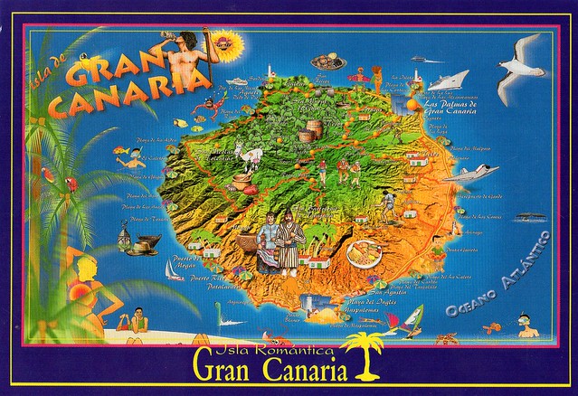
Gran Canaria is the second most populous island of the Canary Islands, a Spanish archipelago, with a population of 838,397 which constitutes approximately 40% of the population of the archipelago. Located in the Atlantic Ocean about 150 kilometres off the northwestern coast of Africa and about 1,350 km from Europe.

Gran Canaria was populated by the Canarii, who may have arrived as early as 500 BC. The Canarii called the island Tamarán or Land of the Brave. After over a century of European (French, Portuguese...) incursions and attempts at conquest, the island was conquered on April 29, 1483, after a campaign that lasted five years, by the Crown of Castile, with the support of Queen Isabella I, a conquest which turned out to be an important step towards the expansion of the unified Spain.

The capital city of Las Palmas de Gran Canaria was founded on June 24, 1478, under the name "Real de Las Palmas", by Juan Rejón, head of the invading Castilian army. In 1492, Christopher Columbus anchored in the Port of Las Palmas (and spent some time on the island) on his first trip to the Americas. Las Palmas de Gran Canaria is, jointly with Santa Cruz de Tenerife, the capital of the autonomous community of the Canary Islands.

Gran Canaria is located southeast of Tenerife and west of Fuerteventura. The island is of volcanic origin, mostly made of fissure vents. Gran Canaria's surface area is 1,560 km² and its maximum elevation is 1,949 meters (Pico de Las Nieves). It has a round shape, with a diameter of approximately 50 km.

Gran Canaria is noted for its rich variety of microclimates. Generally speaking though, the average daytime high ranges from 20 °C in winter, to 26 °C in summer. Some cool nights occur in winter, but lows below 10 °C are unknown near the coast. Inland the climate is still mild but mountainous areas see the occasional frost or snow. Annual rainfall averages 228 mm, most of this falling in the cooler months, with July, August and September normally rainless. Rainfall is unevenly distributed through the island with some areas being much drier than others. Cloud cover and sunshine is often quite variable during the cooler months, and there can be several rather cloudy days at times in winter. Summers are generally quite sunny however, with the south of the island being most favoured.

This island is called a "Miniature Continent" due to the different climates and variety of landscapes found, with long beaches and dunes of white sand, contrasting with green ravines and picturesque villages. A third of the island is under protection as a Biosphere Reserve by UNESCO.

The number of annual visitors is 2.2 million. Most of the tourists visit the southern part of the island. The north tends to be cooler, while the south is warmer and sunny. The east coast of the island is flat, dotted with beaches, while the western coast is rockier and mountainous.