Tuesday 31 March 2015

street vendor, Vietnam

One more card for today, another lovely Vietnam view showing local life, sent by Jo. :) There seem to be a lot of postcards like this available in Vietnam, and I absolutely adore these, in my opinion these are generally a lot nicer than your typical touristic views.


I don't think I'd be able to ride a bike with this much carriage...! :O This looks pretty impressive. ...not to mention all the produce here, which I assume must be pretty fresh as well. Mmmm... I'm getting hungry!

Mae Hong Son, Thailand

Continuing on the lunar year theme... I received this beautiful postcard last year. I was looking for postcards with Year of the Horse stamps and A of Thailand kindly agreed to swap with me.


Mae Hong Son is a town (thesaban mueang) in northwest Thailand, capital of Mae Hong Son Province. It is in the Shan Hills, near the border with Burma along the banks of the River Pai. As of 2005, the town had some 6,023 inhabitants.

Mae Hong Son Province is one of the northern provinces (changwat) of Thailand, on the country's western border. Neighboring provinces are (clockwise from north) Shan State of Myanmar, Chiang Mai and Tak. To the west, the province borders Kayin State and Kayah State of Myanmar.

The name Mae Hong Son means "the city of three mists". It is hemmed in by the high mountain ranges of the Shan Hills and is the most mountainous province in Thailand and is occupies 13,814 square kilometres. The province is covered with mist throughout the year and its terrain is highly suitable for the training of elephants.

Year of the Goat, Australia

A lovely Year of the Goat postcard from dear Heather! She was nice enough to use Australian Year of the Goat stamps on this postcard, too, even though it was already pre-paid.


It does still confuse me a bit that this year has a different name in different countries. I'm still not quite sure how I should label it - I've gone with 'sheep' as that's how it seems to be called over here and in Finland as well.

Jubilee Villas, Port Stanley, Falkland Islands

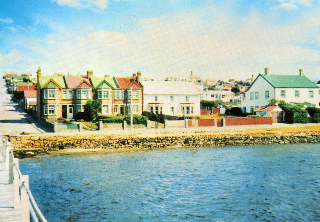
This postcard is actually unwritten, but I'm not expecting to receive a written and stamped one any day soon so this will do for my collection for now.


The Falkland Islands are an archipelago in the South Atlantic Ocean on the Patagonian Shelf. The principal islands are about 480 km east of South America's southern Patagonian coast. The archipelago, with an area of 12,000 km2, comprises East Falkland, West Falkland and 776 smaller islands. As a British overseas territory, the Falklands have internal self-governance, and the United Kingdom takes responsibility for their defence and foreign affairs. The islands' capital is Stanley on East Falkland.

Controversy exists over the Falklands' discovery and subsequent colonisation by Europeans. At various times, the islands have had French, British, Spanish, and Argentine settlements. Britain reasserted its rule in 1833, although Argentina maintains its claim to the islands. In April 1982, Argentine forces temporarily occupied the islands. British administration was restored two months later at the end of the Falklands War.

The population (2,932 inhabitants in 2012) primarily consists of native-born Falkland Islanders, the majority of British descent. Other ethnicities include French, Gibraltarian and Scandinavian. Immigration from the United Kingdom, the South Atlantic island of Saint Helena, and Chile has reversed a population decline. The predominant (and official) language is English. Under the British Nationality (Falkland Islands) Act 1983, Falkland Islanders are British citizens.

The islands lie on the boundary of the subantarctic oceanic and tundra climate zones, and both major islands have mountain ranges reaching 700 m. They are home to large bird populations, although many no longer breed on the main islands because of competition from introduced species. Major economic activities include fishing, tourism and sheep farming, with an emphasis on high-quality wool exports. Oil exploration, licensed by the Falkland Islands Government, remains controversial as a result of maritime disputes with Argentina.

Greetings from Spain

This was one of those Greetings from postcards that I thought was going to be difficult to get hold of... and then I ended up receiving two! :D One was sent by Laura, who incidentally also sent me my Finland 'Greetings from' postcard, and the other one is from Reyes.


When I first saw this card I thought it was nice to see a person on these cards, as opposed to the usual views. However, Reyes wasn't happy about the picture on this card at all, as she pointed out to me that like many Spanish people, she hates bullfighting (my friend Wanda does, too - don't even get her started on the topic!), and I've heard the same comment from other people. I think Laura said something about this, too...?? I do wonder now why this image was chosen for this postcard...?!

Plitvice Lakes National Park, Croatia

A lovely Unesco card from Agi, received a couple of years ago. Isn't this a stunning view?!


Plitvice Lakes National Park is the oldest national park in Southeast Europe and the largest national park in Croatia.

The national park was founded in 1949 and is situated in the mountainous karst area of central Croatia, at the border to Bosnia and Herzegovina. The important north-south road connection, which passes through the national park area, connects the Croatian inland with the Adriatic coastal region.

The protected area extends over 296.85 square kilometres. About 90% of this area is part of Lika-Senj County, while the remaining 10% is part of Karlovac County.

In 1979, Plitvice Lakes National Park was added to the UNESCO World Heritage register among the first natural sites worldwide. Each year, more than 1,200,000 visitors are recorded.

Vyborg, Russia

I'm from Lappeenranta, Finland. It's almost right on the Russian border but I've never been to Russia. ...and Vyborg would only be around 60 kilometres from where I've lived most of my life! It's just never happened. It does interest me, but my family aren't too bothered so I doubt I'll ever get to visit. Oh well, I do have a couple of postcards from Vyborg, this painted view being one of them.


Vyborg (Finnish: Viipuri) is a town and the administrative center of Vyborgsky District in Leningrad Oblast, Russia, located on the Karelian Isthmus near the head of the Vyborg Bay, 130 kilometers to the northwest of St. Petersburg and 38 kilometers south of Russia's border with Finland, where the Saimaa Canal enters the Gulf of Finland. Population: 79,962 (2010 Census).

The town lies in the boundary zone between the East Slavic/Russian and Finnish worlds and has changed hands several times in history, most recently in 1944 when it was taken by the Soviet Union from Finland during World War II.

The city hosts the Russian end of the 1,222 km Nord Stream gas pipeline, laid in 2011 and operated by a consortium led by Russia's Gazprom state hydrocarbons enterprise to pump 55 billion cu m of natural gas a year under the Baltic to Greifswald, Germany.

Round Tower, shown on this postcard, is a fortification at the market square of Vyborg. It was built in 1547–1550 by the order of Gustav I of Sweden as a part of the medieval town wall. Today it serves as a restaurant and is one of the most popular sights in Vyborg.

Round Tower was originally an arsenal. It was later used as a prison called "The Mutton Prison", a warehouse and since 1861 by the city magistrate. In 1938, as Vyborg was part of Finland, the tower was renovated for restaurant use after the design of architect Uno Ullberg. Tower's diameter is circa 21 meters.

Sunday 22 March 2015

Barbados

...and here is the second postcard I received from Phyllis from her holiday last year. :) She does travel quite a bit - she'll be going away again on Tuesday. I'm not jealous at all, nooo... :P


Not that much to say about this... except that the views do look gorgeous and I wouldn't mind visiting Barbados at all. :D

The ancient fishing port of Aberdeen, Hong Kong

A slightly different view of Hong Kong. I really like this one and was really happy to receive this from Natalie of Hong Kong. ...and I also really love the heart stamp she used! :)


Aberdeen is an area and town on the Hong Kong Island in Hong Kong. Administratively, it is part of the Southern District. This town is named Aberdeen in memory of George Hamilton-Gordon, 4th Earl of Aberdeen, former Prime Minister of the United Kingdom (1852-1855) and former Secretary of State for Foreign Affairs (1841-1846). 'Aberdeen' can refer to the areas of Aberdeen (town), Wong Chuk Hang, Ap Lei Chau and Tin Wan, but it is more often used to refer to the town only. According to the Population Census conducted in 2011, the total population of Aberdeen area is approximately 80,000. (Population : 20033, Aberdeen town; 26260, Ap Lei Chau; 17426, Tin Wan; 16012, Wong Chuk Hang.)

Aberdeen Harbour is the harbour between Aberdeen (town) and Ap Lei Chau, and is one of the nine harbours in Hong Kong. It is well known for its view and is a popular tourist spot. During fishing moratorium and the typhoon weather, Aberdeen Typhoon Shelters are the parking spot for fishing vessels owned by local fishermen.

Aberdeen Centre is a well-known private housing estate located in Aberdeen town, owned by Hutchison Whampoa Limited company. The twenty buildings (blocks), providing 2,788 private apartments, have been the accommodations where mainly Hong Kong middle-class families lived in for more than thirty years.

Aberdeen is famous to not only tourists but also Hong Kong locals for its floating village and floating seafood restaurants located in the Aberdeen Harbour. The Tanka people, who used to live on boats in the Aberdeen Harbour are generally associated with the fishing industry, and there are still several dozens of them living on boats in the harbour.

Sacred Sites and Pilgrimage Routes in the Kii Mountain Range, Japan

A lovely Unesco card from Japan I received some time ago. This place looks absolutely gorgeous!


Set in the dense forests of the Kii Mountains on a peninsula in the southernmost part of mainland Japan, overlooking the Pacific Ocean, three sacred sites – Yoshino and Omine, Kumano Sanzan, and Koyasan – are linked by pilgrimage routes to the ancient capital cities of Nara and Kyoto. Together these sites, the connecting pilgrimage routes, and surrounding forests form a cultural landscape that reflect the fusion of Shintoism, rooted in the ancient tradition of nature worship in Japan, and Buddhism, which was introduced from China and the Korean Peninsula. The sacred sites are connected by 307 km of pilgrimage routes which cover a total area of 495.3 ha. With the surrounding forest landscape, they reflect a persistent and extraordinarily well-documented tradition of sacred mountains maintained over 1,200 years.

Greetings from Holland!

A slightly different 'greetings from' postcard! :D This is one of the many wonderful postcards I received when I was the 'winner of the month' on the Postcrossing forum back in September 2013.


This is SUCH a cool postcard, I love all the little details and the fact that there are explanations as well as I would have no clue otherwise as to what some of these things are. Miffy is still one of my favourite things from the Netherlands. Well, that and gouda cheese. :D

Greetings from Estonia

This postcard only arrived last week. I'd been looking for this one for quite a while... Thank you SO much for the swap, Janne!

Ohhh, and the new 'Greetings from' postcards should be out any time now. I really hope this time more have been printed than before so that they won't be sold out within a day/a few hours like seems to have happened before. Surely the designer/shop owner should realise by now how popular these postcards are and print enough?! Also, it seems like this time it could be pretty much impossible to get some of the cards written and stamped from their country of origin. :/


I think I'd read somewhere before that Skype was invented in Estonia. It's SUCH a lovely invention, too, I'm forever grateful to the Estonian programmers as it means I can talk to my family in Finland without having to spend a fortune on phone credit. ...even if we can't really use the video feature as well because it tends to screw up the calls, but that must be because there's something wrong with our internet connection. Hmmm... Not very nice, but at least I can still talk to my parents.

Posázavský Pacifik, Czech Republic

This is one of the postcards I've received through 'Postcard United' (with postcard ID 'CZE-825). I haven't received any more for a while now but I still got way more than received. I wonder if any more are on their way...


This is a famous rail route in Czech Republic, called Posázavský Pacifik. I found some information on this website:

Posázavský Pacifik is the name for a recreational historical route following the Sázava River, which courses through the hilly countryside of Central Bohemia, southeast of Prague. The route’s name originates in the tramping sub-culture. Various cottages along the route were named after places from the Pacific Coast of America.

You can read more on that website, it's quite interesting as well. :)

a tiny post office, North Carolina, USA

This is a slightly older card, received six year ago as an official. I'd been meaning to post it here for ages but something was always playing up with Flickr when I tried. Well, here it is now.

 
US-356730
 
What a cute little post office! It's located in Salvo in North Carolina, USA. The sender told me that it looks more like a child's playhouse and the post mistress is an elderly lady.

Salvo is a census-designated place located in Dare County, North Carolina, on Hatteras Island, part of North Carolina's Outer Banks. Originally (with Rodanthe and Waves) part of the settlement of Chicamacomico, Salvo was originally known as Clarks or Clarksville.

The name "Salvo" allegedly stems from the American Civil War, during which a passing Union vessel spotted the settlement, which was not marked on their maps. The commanding officer ordered an attack, and a sailor marked the site on his map with the word "Salvo." The name was formally given to the town when it received a post office in 1901. The Salvo post office, zip code 27972, one of the smallest postal facilities in the United States, was damaged by an arsonist in 1992. A new post office was constructed later in the decade for all of Chicamacomico. Hurricane Sandy in October 2012 damaged much of the Outer Banks area including Salvo.

Wednesday 18 March 2015

Lundy Island

I only recently found out about Lundy Island and the fact that it has its own stamps (with 'puffin' values). I suppose you could call it cheating when I organised a couple of postcards to be sent to myself from there without going there myself but oh well. :P

One thing I wanted to say as well... When organising these postcards to be sent to me, I exchanged some emails with the Lundy Postmaster. I guess the clue should have been in the name ('mister', not 'mistress') but I'm not very bright sometimes and as the Postmaster's name sounded female, I used the title 'Ms', thinking I was being polite. Well, it turned out the Postmaster is 'MR'. I was SO embarrassed when I found out! Lundy Postmaster, if you happen to be reading this for some reason, I wish to apologise wholeheartedly. I never meant to offend. ...and I'm also kind of glad that titles aren't that commonly used in Finland. :P


Lundy is the largest island in the Bristol Channel. It lies 19 km off the coast of Devon, England, about a third of the distance across the channel from Devon, England to south Wales. Lundy gives its name to a British sea area and is one of the islands of England. Lundy has been designated by Natural England as national character area 159, one of England's natural regions.

In 2007, Lundy had a resident population of 28 people, including volunteers. These include a warden, ranger, island manager, and farmer, as well as bar and house-keeping staff. Most live in and around the village at the south of the island. Most visitors are day-trippers, although there are 23 holiday properties and a camp site for staying visitors, mostly also around the south of the island.

In a 2005 opinion poll of Radio Times readers, Lundy was named as Britain's tenth greatest natural wonder. The entire island has been designated as a Site of Special Scientific Interest and it was England's first statutory Marine Nature Reserve, and the first Marine Conservation Zone, because of its unique flora and fauna. It is managed by the Landmark Trust on behalf of the National Trust. You can read more about Lundy here.

Dubla Island, the Sundarbans, Bangladesh

My dear friend Wanda visited Bangladesh a little over a year ago. I was cheeky and asked if she could send me some postcards, and she did. :) I've already posted one here before, but here's another. This one is actually a Unesco site as well!


The Sundarbans is a natural region in Bengal. It is the largest single block of tidal halophytic mangrove forest in the world. The Sundarbans covers approximately 10,000 square kilometres of which 60 percent is in Bangladesh with the remainder in India. The Sundarbans is a UNESCO World Heritage Site.

The Sundarbans National Park is a National Park, Tiger Reserve, and a Biosphere Reserve located in the Sundarbans delta in the Indian state of West Bengal. Sundarbans South, East and West are three protected forests in Bangladesh. This region is densely covered by mangrove forests, and is one of the largest reserves for the Bengal tiger.

Greetings from Portugal

This was one of the trickier 'Greetings from' postcards to get hold of - and then I ended up receiving two, with exactly the same stamp as well! :D I've picked the one where the stamp was cancelled for this post.


I like the fact that Paulo Magalhães, the founder of the Postcrossing project, is mentioned on the card. ...and the project has been ongoing for so long now! I wonder if there's going to be something a bit bigger this summer to celebrate the 10th anniversary?

Also, a random fact from myself: Portugal was the first foreign country I ever visited. I was about seven years old at the time, though, so I can't remember *too* much. I do remember having a wonderful time, though, and would love to go back one day.

Auschwitz Birkenau, Poland

A rather creepy card for now... I don't think I'd ever be able to stomach visiting this place, I think it would just be way too much. On a slightly different note, I don't want to get too much into politics here as this isn't the place, but I find it odd how there doesn't seem to be nearly the same level of outrage at the fact that concentration camps still exist in North Korea. I've read a couple of really, really grim books on the topic recently and was pretty horrified. I mean there's Holocaust Memorial Day and everything (and for a good reason, too), but why isn't there more campaigning against the ones that still exist - how can you have a slogan like 'Never Again' in these circumstances?? Unless I've missed something...


Auschwitz Birkenau
German Nazi Concentration and Extermination Camp (1940-1945)

The fortified walls, barbed wire, platforms, barracks, gallows, gas chambers and cremation ovens show the conditions within which the Nazi genocide took place in the former concentration and extermination camp of Auschwitz-Birkenau, the largest in the Third Reich. According to historical investigations, 1.5 million people, among them a great number of Jews, were systematically starved, tortured and murdered in this camp, the symbol of humanity's cruelty to its fellow human beings in the 20th century.

Tbilisi, Georgia

This postcard was actually sent from Spain but it's still one of my only postcards of Georgia. Such a nice night view, too!


Tbilisi, formerly known as Tiflis, is the capital and the largest city of Georgia, lying on the banks of the Mtkvari River with a population of roughly 1.5 million inhabitants. Founded in the 5th century by the monarch of Georgia's ancient precursor Kingdom of Iberia, Tbilisi has since served, with intermissions, as the Georgian capital. Formerly, the city had also served as the seat of the Imperial administration of the Caucasus during the Russian rule from 1801 to 1917, the capital of the short-lived Transcaucasian Democratic Federative Republic in 1918, of the Democratic Republic of Georgia from 1918 to 1921, of the Georgian Soviet Socialist Republic from 1921 to 1991, and the Transcaucasian Socialist Federative Soviet Republic from 1922 to 1936.

Located on the southeastern edge of Europe, Tbilisi's proximity to lucrative east-west trade routes often made the city a point of contention between various rival empires throughout history and the city's location to this day ensures its position as an important transit route for global energy and trade projects. Tbilisi's varied history is reflected in its architecture, which is a mix of medieval, classical, and Soviet structures.

Historically, Tbilisi has been home to people of diverse cultural, ethnic, and religious backgrounds, though it is overwhelmingly Eastern Orthodox Christian. Notable tourist destinations include cathedrals like Sameba and Sioni, classical Freedom Square and Rustaveli Avenue, medieval Narikala Fortress, pseudo-Moorish Opera Theater, and the Georgian National Museum.

Tunisia

I have a bit of a thing for postcards showing doors and windows, so I was really happy to receive this one from Anne from her holiday. :)


Not much to say about this... except that I really like the colours here! I've seen some pretty nice doors in Bridgnorth here in England, too, you could do a similar postcard there.. :P

Monday 16 March 2015

Wisconsin map, USA

For a few years I thought I had completed my US state map postcard collection and thought that when I finally managed to get North Dakota, I was done. I was going through my albums on Flickr the other day, though, and realised I didn't have a map card of Wisconsin. How did that happen?? Well, now my collection really should be complete. :P

I used to have a penpal in Wisconsin years and years ago but sadly we've pretty much lost touch since. Well, she's on Facebook but I'm pretty rubbish at keeping up to date with my friends' pages there. I do miss her letters but life sometimes gets in the way and things happen.


Wisconsin is a U.S. state located in the north-central United States, in the Midwest and Great Lakes regions. It is bordered by Minnesota to the west, Iowa to the southwest, Illinois to the south, Lake Michigan to the east, Michigan to the northeast, and Lake Superior to the north. Wisconsin is the 23rd state by total area and the 20th most populous. The state capital is Madison, and its largest city is Milwaukee, which is located on the western shore of Lake Michigan. The state comprises 72 counties.

Wisconsin's geography is diverse, with the Northern Highland and Western Upland along with a part of the Central Plain occupying the western part of the state and lowlands stretching to the shore of Lake Michigan. Wisconsin is second to Michigan in the length of its Great Lakes coastline.

Wisconsin is known as "America's Dairyland" because it is one of the nation's leading dairy producers, particularly famous for cheese. Manufacturing, especially paper products, information technology (IT), and tourism are also major contributors to the state's economy.

Greetings from Taiwan

I had some issues getting this one. I arranged one swap a while back but still haven't received the card (and I don't know if my swap partner received hers as I haven't heard anything from her. Should really message her...). I asked for another swap with a different person later on and this time the card arrived safely.


I love the colours in this one - a lot of the postcards in this series are a tad too light and pastel-coloured for my liking, even if I do still like them, but this is just right. :)

 I've only ever tried bubble tea once, in Birmingham a couple of years ago. I quite liked it, although it didn't really taste like tea to me... More like a nice sweet drink with the tapioca pearls somehow reminding me of gummy sweets.

 Also, I hadn't realised there were that many Postcrossing members in Taiwan!

Year of the Sheep, UK

Just a small update for this evening, starting with a couple of sheep postcards from the UK that I sent to myself as I wanted some Year of the Sheep stamps on postcards. Surprisingly both even got cancelled the first time!


This postcard series by Tim Grevatt is absolutely gorgeous. I have no idea where these are sold, though, as I've never seen them sold anywhere. I do have a couple that I've received through Postcrossing.


This one is from Cymric Cards, also a very nice series and stunning photos of Wales and photos and cute animals as well. :)

Sunday 15 March 2015

Les Saintes, Terre-de-Haut, Guadeloupe

Phyllis, a friend of mine from volunteering, went on a Caribbean cruise last year. I was cheeky and asked if she could send me a couple of postcards from her trip, and she did send me two: this one of Guadeloupe mailed from Barbados, and one from Barbados. It would be so cool to go on one of those cruises myself one day... My Canadian pen friend has just been on one, too... *jealous* ..and my sister-in-law has just got a job on a cruise line so she'll get to visit some pretty amazing places as well, I'd think.


The Îles des Saintes ("Islands of the Saints"), also known as Les Saintes, is a small archipelago of the French Antilles located to the south of Basse-Terre Island, west of Marie-Galante and north of Dominica. It is a dependency of Guadeloupe, which, in turn, is an overseas department and region of France.

 Terre-de-Haut is a commune in the French overseas department of Guadeloupe, including Terre-de-Haut Island and a few other small uninhabited islands of the archipelago (les Roches Percées; Îlet à Cabrit; Grand-Îlet; la Redonde). It is the most populous island of the archipelago of the les Saintes.

Champasak, Laos

This is still one of my only postcards of Laos, and it's a really nice one, too. This one was sent from Malaysia.


Champasak is a province in southwestern Laos, near the borders with Thailand and Cambodia. It is one of the three principalities that succeeded the Lao kingdom of Lan Xang. In 2005, it had a reported population of 607,333. The capital is Pakse, but it takes its name from Champasak, the former capital of the Kingdom of Champasak. Champasak Province covers an area of 15,415 square kilometres. It is bordered by Salavan Province to the north, Sekong Province to the northeast, Attapeu Province to the east, Cambodia to the south, and Thailand to the west. The river Mekong forms part of the border with neighboring Thailand and contains Si Phan Don (Four Thousand Islands) in the south of the province, on the border with Cambodia.

Champasak has played a central role in the history of Siam and Laos, with frequent battles taking place in and around Champasak. Its rich cultural heritage includes ancient temple ruins and French colonial architecture. Champasak has some 20 wats (temples), such as Wat Phou, Wat Luang, and Wat Tham Fai. Freshwater dolphins and the province's many waterfalls are tourist attractions.


The Champasak cultural landscape, including the Vat Phou Temple complex, is a remarkably well-preserved planned landscape more than 1,000 years old. It was shaped to express the Hindu vision of the relationship between nature and humanity, using an axis from mountain top to river bank to lay out a geometric pattern of temples, shrines and waterworks extending over some 10 km. Two planned cities on the banks of the Mekong River are also part of the site, as well as Phou Kao mountain. The whole represents a development ranging from the 5th to 15th centuries, mainly associated with the Khmer Empire.