Saturday 24 December 2011

Merry Christmas!


Have a lovely Christmas if you celebrate it!

Saturday 17 December 2011

The Khibiny Mountains, Russia

Today's last card is one of the many beautiful postcards I received from Andrey in Russia from a swap earlier this year. It's so difficult to choose which Russian postcards to post in this blog because I have SO many absolutely gorgeous views from there. I picked this one as it's slightly different to most Russian views - I don't tend to associate northern lights with Russia!


The Khibiny Mountains (or The Khibiny Massif) is one of the two main mountain ranges of the Kola Peninsula, Russia, within the Arctic Circle, located between Imandra and Umbozero lakes.

The massif is of oval shape of about 1,300 km2. and occupies the central part of the peninsula at a relative elevation of 900-1000 m above the surrounding plain. The mountains are not particularly high; the two highest peaks are the Yudytchvumtchchorr, which stands 1,201 metres, and the Chasnachorr, which stands 1,191 metres. The average elevation is 1,116 metres. The mountains form the shape of a horseshoe topped by a high plateau, drained by a series of deep canyons. The peaks are of plateau type, with steep slopes, with glaciers, icefields and snowfields in some places. The overall terrain is alpine tundra.

The massif is extremely rich in various minerals, mainly apatite and nepheline ores. 477 valid minerals have been reported and 108 of those are type localities or minerals first described in the Khibiny.

The Khibinskys are mostly uninhabited, except for one of the world's richest mineral quarries, with approximately 10% of all new minerals discovered there, including one that can potentially absorb radioactivity from nuclear waste. The cities of Apatity and Kirovsk are situated at the foot of the massif.

Toronto, Canada

A gorgeous winter view of Nathan Phillip's Square in Toronto I received from my friend Kristen a couple of months ago. I just love the lights here, they look so magical!


Nathan Phillips Square is an urban plaza that forms the forecourt to Toronto City Hall, or New City Hall, at the intersection of Queen Street West and Bay Street, and named for Nathan Phillips, mayor of Toronto from 1955 to 1962. The square opened in 1965, and, as with the City Hall, the square was designed by architect Viljo Revell (a Finnish architect!!). The square is the site of concerts, art displays, a weekly farmers' market, the winter festival of lights, and other public events, including demonstrations.

Hobart, Tasmania

I know I already follow too many tv series, but I just couldn't resist The Mentalist. I'd seen bits and pieces as Matt's parents follow the series and I quite liked what I'd seen, so I thought I'd try watching the first couple of episodes from season 1. ...and now I'm hooked. :P Ooops. Simon Baker (who plays the main character, Patrick Jane) is originally from Australia and was born in Tasmania. ...which looks like a really interesting area and one I don't know too much about.


Hobart is the state capital and most populous city of the Australian island state of Tasmania. Founded in 1804 as a penal colony, Hobart is Australia's second oldest capital city after Sydney. In 2009, the city had a greater area population of approximately 212,019. A resident of Hobart is known as a "Hobartian". The city is located in the state's south-east on the estuary of the Derwent River. The skyline is dominated by Mount Wellington at 1,271 metres high.

The city is the financial and administrative heart of Tasmania, also serving as the home port for both Australian and French Antarctic operations.

Hobart was named Australia's 6th most sustainable city, by the Australian Conservation Foundation in 2010. For economic and social innovation, Hobart was the 11th placed in Australia in 2009, and listed as an innovation influencer city in the Innovation Cities Global Index scoring equal with Reykjavik, Katowice and Casablanca by 2thinknow.

Hissar, Bulgaria

I'm pretty nervous at the moment - tomorrow it'll be Aikido gradings in Birmingham and I'm be going for brown belt. I keep thinking what if my mind goes blank and I just forget everything, or do something stupid... Wish me luck! I'm also a bit worried about actually getting to Birmingham (and then back home) as it's supposed to snow here this weekend and the traffic is always a total chaos if it does. :S ...that, and I wish my friend Miranda was there tomorrow, I could do with some support from her. She's on holiday at the moment, though, back home in Hong Kong and she'll also be visiting Taiwan (and she said she'd bring me back postcards :)). She gets to travel so much! Earlier this year she visited Bulgaria. It wasn't just for fun and relaxation although she did get to do that as well. Anyway, she brought me back a couple of postcards and I thought I'd show one of them here.


Hissar is a small resort town in Bulgaria, in Plovdiv Province. Located in the outskirts of the Sredna Gora mountain range, it boasts of a very mild climate and over two dozen different mineral springs, which make it a favorite spa for many Bulgarian and foreign tourists. The town's population is 7,691. The population of the municipality is approximately 14,826.

Because of these springs, the town was founded thousands of years ago. Some pre-historic remains have been found in what is now the town centre. Later, it became a Thracian city, and when Thrace fell to the Romans and became a Roman province, Hisarya became a Roman town - one of the three most important towns in the province. At various times it was called Augusta, Diocletianopolis (after emperor Diocletian) and a couple of other names. It was a famous resort even in those times, which is proved by the fact that emperor Septimius Severus himself visited the city.

Many Roman ruins are still visible everywhere - public buildings, a small amphitheatre, the barracks of the Roman garrison, the foundations of a couple of the oldest churches in Bulgaria, as well as the best preserved Roman fortress in Bulgaria. The southern gate is known as "The Camels", because it had broken in the middle and looked like two camels facing each other, before it was partially restored in the early 20th century.

Saturday 10 December 2011

Mantenga Cultural Village, Swaziland

One more card for today... and it's a new country to my collection! Well, it wasn't mailed directly from Swaziland but I think that would be a bit too much to ask. This is another treat from the lovely Kim in Taiwan. Thank you so much!


Swaziland, officially the Kingdom of Swaziland, is a landlocked country in Southern Africa, bordered to the north, south and west by South Africa, and to the east by Mozambique. The nation, as well as its people, are named after the 19th century king Mswati II.

Swaziland is a small country, no more than 200 kilometres north to south and 130 kilometres east to west. The western half is mountainous, descending to a lowveld region to the east. The eastern border with Mozambique and South Africa is dominated by the escarpment of the Lebombo Mountains. The climate is temperate in the west, but may reach 40 °C in summer in the lowveld. Rainfall occurs mainly in the summer and may reach 2 metres in the west.

The area that Swaziland now covers has been continuously inhabited since prehistory. Today, the population is primarily ethnic Swazis whose language is siSwati, though English is spoken as a second language. The Swazi people descend from the southern Bantu who migrated from Central Africa in the 15th and 16th centuries. The Anglo Boer war saw the United Kingdom make Swaziland a protectorate under its direct control. Swaziland gained independence in 1968. Swaziland is a member of the Southern African Development Community, the African Union, and the Commonwealth of Nations. The head of state is the king, who appoints the prime minister and a small number of representatives for both chambers of parliament. Elections are held every five years to determine the majority of the representatives. A new constitution was adopted in 2005.

Some 75% of the population are employed in subsistence farming, and 60% of the population live on less than the equivalent of US$1.25 per day. Swaziland's main trading partner is South Africa, and its currency is pegged to the South African rand.


Kim mailed the postcard from Taiwan so the stamps are obviously from Taiwan as well.

Burj Al Arab, Dubai

Dubai is another one of those places where I only have a few postcards from. ...and this is even older than the India postcard - I received this one in 2008!


Burj Al Arab is a 5-star (often misleadingly referred to as 7-star) luxury hotel located in Dubai, United Arab Emirates. At 321 m, it is the fourth tallest hotel in the world. Burj Al Arab stands on an artificial island 280 m out from Jumeirah beach, and is connected to the mainland by a private curving bridge.

Burj Al Arab was designed by British architect Tom Wright of WS Atkins PLC. The design and construction were managed by Canadian engineer Rick Gregory also of WS Atkins. Construction of the Island began in 1994. It was built to resemble the sail of a dhow, a type of Arabian vessel. Two "wings" spread in a V to form a vast "mast", while the space between them is enclosed in a massive atrium. The building opened in December 1999.

Periyar, Kerala, India

Let's stay in Asia for a bit longer, this time moving on to India. I don't know why I hardly ever receive any official Postcrossing cards from there - out of the 1,410 officials I've received, only three are from India. The card here is the latest one of them, and I received it in June 2009! It doesn't even look like India is *that* rare a country anymore, at least if you look at the postcard IDs. Oh well, maybe one day...


IN-7635


Periyar is the longest river in the state of Kerala, India, with a length of 244 km. The Periyar is known as the lifeline of Kerala; it is one of the few perennial rivers in the region and provides drinking water for several major towns. The Idukki Dam on the Periyar generates a significant proportion of Kerala's electrical power.

Kerala is an Indian state located on the Malabar coast of south-west India. It was created on 1 November 1956 by the States Reorganisation Act by combining various Malayalam speaking regions.

The state has an area of 38,863 km2 and is bordered by Karnataka to the north and northeast, Tamil Nadu to the south and southeast, and the Arabian Sea[note] on the west. The city of Thiruvananthapuram is the state capital. Kochi and Kozhikode are other major cities. According to a survey by The Economic Times, five out of ten best cities to live in India are located in Kerala. Kerala is a popular tourist destination for its backwaters, yoga, Ayurvedic treatments and tropical greenery.

Kerala has the highest Human Development Index in India, comparable with that of first world nations but with a much lower per capita income. The state has the highest literacy rate in India with 99 percent. The state recently became and is currently the only one to have banking facilities in every village. A survey conducted in 2005 by Transparency International ranked Kerala as the least corrupt state in the country. Kerala has witnessed significant migration of its people, especially to the Persian Gulf countries during the Kerala Gulf boom and is heavily dependent on remittances from its large Malayali expatriate community.

Lonon Falls, The Philippines

A gorgeous waterfall view I received from the lovely Maerose. I collect waterfall postcards so any new cards are always more than welcome! :)


from the back of the postcard:

LONON FALLS
Lake Sebu, South Cotabato
popularly known as the Seven Falls, it features series of seven waterfalls of majestic cascades lined-up one after the other.


South Cotabato is a province of the Philippines located in the SOCCSKSARGEN region in Mindanao. Its capital is Koronadal City, and it borders Sultan Kudarat to the north and west, Sarangani to the south and east, and Davao del Sur to the east. To the southeast lies Sarangani Bay.

General Santos City, on the shores of Sarangani Bay, is the largest and most important city in the region, and is a major seaport. The province of Sarangani used to be part of South Cotabato until it was made an independent province in 1992.

Kununurra, Western Australia

No snow here so far, I hope it'll stay that way. ...although it's still pretty chilly and I think I've managed to get ill. I've been sneezing and my nose has been running like silly since yesterday, not cool. I really wouldn't mind being somewhere warm and sunny right now... *sigh* Since that's not possible, today's postcards are all from faraway, warm places. The first card is from Heather, a wonderful person and one of my favourite swappers. It's always a pleasure to find a postcard from her in my mailbox.


Kununurra is a town in far northern Western Australia located at the eastern extremity of the Kimberley Region approximately 37 kilometres from the border with the Northern Territory. Kununurra was initiated to service the Ord River Irrigation scheme.

Kununurra is the largest town in Western Australia north of Broome, with the closest town being Wyndham, 100 kilometres away. Kununurra is 3,040 kilometres from Perth via the Great Northern Highway (distances in Australia never cease to amaze me!!).

The town is situated in among the scenic hills and ranges of the far north-east Kimberley Region, having an abundance of fresh water, conserved by the Ord River Diversion dam and the main Ord River Dam.

On this postcard you can see Elephant Rock, situated on the Ord River. Elephant Rock is also known as Sleeping Buddha, and it's one of the several spectacular backdrops to the town of Kununurra.


I love food-themed stamps and these are AMAZING!

Thursday 8 December 2011

Longyearbyen, Svalbard, Norway

Today's last card made me really excited when I received it. When I had joined the RR on the Postcrossing forum, I didn't realise Spitsbergen was in Svalbard and I never thought I'd ever get a postcard from there. ...and then this gem arrived! :)


Longyearbyen is the largest settlement and the administrative centre of Svalbard, Norway. It is located on the western coast of Spitsbergen, the largest island of the Svalbard archipelago, on the southern side on Adventfjorden , which continues inland with Adventdalen . The Governor of Svalbard and his administration reside in Longyearbyen.

Longyearbyen has approximately 2,060 inhabitants (at the end of 2007). It is the world's most northerly town, and the most northerly settlement with a population greater than 1,000.

Svalbard is an archipelago in the Arctic, constituting the northernmost part of Norway. It is located north of mainland Europe, midway between mainland Norway and the North Pole. The group of islands range from 74° to 81° north latitude (inside the Arctic Circle), and from 10° to 35° east longitude. Spitsbergen is the largest island, followed by Nordaustlandet and Edgeøya. The administrative center is Longyearbyen, and other settlements include the Russian mining community of Barentsburg, the research community of Ny-Ålesund and the mining outpost of Sveagruva. The archipelago is administered by the Governor of Svalbard.

The islands were first utilized as a whaling base in the 17th and 18th centuries, after which they were abandoned. Coal mining started at the beginning of the 20th century, and several permanent communities were established. The Spitsbergen Treaty of 1920 recognizes Norwegian sovereignty, and the 1925 Svalbard Act made Svalbard a full part of the Kingdom of Norway. This act also established Svalbard as a free economic zone and a demilitarized zone. The Norwegian Store Norske and the Russian Arktikugol are the only mining companies remaining on the islands. Research and tourism have become important supplementary industries. Two major research facilities are the University Centre in Svalbard and the Svalbard Global Seed Vault. No roads connect the settlements; instead snowmobiles, aircraft and boats serve inter-community transport. Svalbard Airport, Longyear serves as the main gateway to the rest of Europe.

The archipelago features an Arctic climate, although with significantly higher temperatures than other areas at the same latitude. The flora take advantage of the long period of midnight sun to compensate for the polar night. Svalbard is a breeding ground for many seabirds, and also features polar bears, reindeer and marine mammals. Seven national parks and twenty-three nature reserves cover two-thirds of the archipelago, protecting the largely untouched, yet fragile, nature. Sixty percent of the archipelago is glacier, and the islands feature many mountains and fjords.

Hundertwasserhaus, Vienna, Austria

More snowy views, this time from Austria. I'd been wanting a postcard of this particular house for ages and finally got one in a tag earlier this year, yay! It's just so gorgeously colourful and whimsical, what's not to love about it?!


Hundertwasserhaus is an apartment house in Vienna, Austria, built after the idea and concept of Austrian artist Friedensreich Hundertwasser with architect Joseph Krawina as a co-author. This expressionist landmark of Vienna is located in the Landstraße district on the corner of Kegelgasse and Löwengasse.

The house was built between 1983 and 1985 according to the ideas and concepts of Hundertwasser with architect Univ.-Prof. Joseph Krawina as a co-author and architect Peter Pelikan as a planner. It features undulating floors ("an uneven floor is a divine melody to the feet"), a roof covered with earth and grass, and large trees growing from inside the rooms, with limbs extending from windows. Hundertwasser took no payment for the design of the house, declaring that it was worth it, to prevent something ugly from going up in its place.

Within the house there are 52 apartments, four offices, 16 private terraces and three communal terraces, and a total of 250 trees and bushes. The Hundertwasser House is one of Vienna's most visited buildings and has become part of Austria's cultural heritage.

Newfoundland, Canada

A small update for a Thursday afternoon before I have to leave for today's aikido class (I'm getting pretty nervous as it's gradings on Sunday next week and I'll be going for brown belt. Wish me luck!). Weather reports are suggesting it could be a really chilly weekend with possibly some snow on its way too, although I do hope it won't reach the West Midlands :P Have some snow on this postcard instead.


CA-189174


Newfoundland is the easternmost province of Canada. Situated in the country's Atlantic region, it incorporates the island of Newfoundland and mainland Labrador (located Northwest of the island) with a combined area of 405,212 square kilometres. As of April 2011, the province's estimated population is 508,400. Approximately 94 percent of the province's population resides on the Island of Newfoundland (including its associated smaller islands), of which over half live on the Avalon Peninsula. The Island of Newfoundland has its own dialects of English, French, and Irish. The English dialect in Labrador is similar to that of Newfoundland. Labrador also has its own dialects of Innu-aimun and Inuktitut.

Newfoundland and Labrador's capital and largest city, St. John's, is Canada's 20th-largest Census Metropolitan Area, and is home to nearly 40 percent of the province's population. St. John's is the seat of government, home to the House of Assembly of Newfoundland and Labrador and the highest court in the jurisdiction, the Newfoundland and Labrador Court of Appeal. A former colony and dominion of the United Kingdom, Newfoundland and Labrador became the tenth province to enter the Canadian Confederation on March 31, 1949, as Newfoundland.

Newfoundland and Labrador is home to a variety of climates and weather. One of the main reasons for this diversity is the geography of the province. The province spans 5.5 degrees of latitude, which is comparable to that of the Great Lakes. The province has been divided into six climate types, but in broader terms Newfoundland has a cool summer subtype of a humid continental climate, which is greatly influenced by the sea since no part of the island is more than 100 km from the ocean. Northern Labrador is classified as a polar tundra climate, southern Labrador have a subarctic climate.

Saturday 26 November 2011

Turkish Republic of Northern Cyprus

Today's last card is quite a treat - one of those places where I never expected to receive a postcard from. Thanks a million Leslie for helping me out!


Northern Cyprus or North Cyprus is a self-declared state which officially titles itself the Turkish Republic of Northern Cyprus (Turkish: Kuzey Kıbrıs Türk Cumhuriyeti). Its territory comprises the northeastern part of the island of Cyprus. Only Turkey has recognised its independence, while the international community considers it occupied territory of the Republic of Cyprus.

Tensions between the Greek Cypriot and Turkish Cypriot populations culminated in 1974 with a coup d'état, an attempt to annex the island to Greece and a military invasion by Turkey in response. All these factors resulted in a partitioning of the island, the resettlement of many of its inhabitants, and a unilateral declaration of independence by the north in 1983. Due to its lack of international recognition, Northern Cyprus is heavily dependent on Turkey for economic, political and military support.

Northern Cyprus extends from the tip of the Karpass Peninsula (Cape Apostolos Andreas) in the north east, westward to Morphou Bay and Cape Kormakitis (the Kokkina/Erenköy exclave marks the westernmost extent of the area), and southward to the village of Louroujina/Akıncılar. A buffer zone under the control of the United Nations stretches between Northern Cyprus and the rest of the island and divides Nicosia, the island's largest city and capital of both states.

... I used to have a friend who was a Turkish Cypriot. She was a member of the Aikido club in Wolverhampton I'm still a member of, but she moved away a few years ago. Should I have been cheeky and ask her to send me a postcard when she went back home on holiday?? :P

Kotor, Montenegro

My dear penpal Snježana went on holiday in Montenegro earlier this year and was kind enough to send me a bunch of postcards of the country. I have to confess I hardly knew anything about Montenegro until I joined Postcrossing. It looks like a really beautiful country, at least the seaside (that's what most of the postcards I have show).


Kotor is a coastal city in Montenegro. It is located in a secluded part of the Gulf of Kotor. The city has a population of 13,510 and is the administrative center of the municipality.

The old Mediterranean port of Kotor is surrounded by an impressive city wall built by the Republic of Venice and Venetian influence remains predominant in the city's architecture. The Bay of Kotor, one of the most indented parts of the Adriatic Sea, is sometimes called the southern-most fjord in Europe (though it is actually a submerged river canyon). Together with the nearly overhanging limestone cliffs of Orjen and Lovćen, Kotor and its surrounding area form an impressive and picturesque Mediterranean landscape.

In recent years, Kotor has seen a steady increase in tourists, attracted by both the natural beauty of the Gulf of Kotor and the old town of Kotor itself.

Kotor is a Unesco World Heritage Site dubbed 'the Natural and Culturo-Historical Region of Kotor'.


Snježana sent me the cards when she was back home so the stamps are from Bosnia.

Comillas, Spain

One more official for today. This one was a bit of a mystery when it arrived, though, as the sender had forgotten to write the ID on the card, and there was also no stamp on the card and I can't tell whether it fell off or if there even was one on the card in the first place. In any case I'm really glad the card made its way to me as I really like it.


ES-130025


Comillas is a small township and municipality in the northern reaches of Spain, in the autonomous community of Cantabria. The Marquisate of Comillas, a fiefdom of Spanish nobility, holds ceremonial office in the seat of power at a small castle which overlooks the town.

The first Marquis of Comillas was Antonio López y López (died 1883). Founder and owner of the Compañía Transatlántica Española, was born in Comillas in 1817. Antonio López y López was given the title in 1878. The current Marquis of Comillas is Don Alfonso Güell y Martos.

When I first saw this card, I really liked the building in the bottom right corner. It looked sort of familiar, and when I looked at the back of the card, it says the building was designed by Gaudí. I feel really embarrassed to admit this, but I always thought the only buildings designed by him were in Barcelona... ooops.. The building here is called 'El Capricho'. It's a small annex to the Palacio de Sobrellano, for the Baron of Comillas. It was commissioned by Máximo Díaz de Quijano and constructed between 1883 and 1885. Cristòfor Cascante i Colom, Gaudí’s fellow student, directed the construction. In an oriental style, it has an elongated shape, on three levels and a cylindrical tower in the shape of a Persian minaret, faced completely in ceramics. The entrance is set behind four columns supporting depressed arches, with capitals decorated with birds and leaves, similar to those that can be seen at the Casa Vicens. Notable are the main lounge, with its large sash window, and the smoking room with a ceiling consisting of a false Arab-style stucco vault.

Gdańsk, Poland

Another official, I received this one around the same time as the card from Latvia. This one is from my favourites as well. I really appreciate it when people take the time to select a card they think the receiver is going to like, and go through the galleries. Not that I don't like surprises as well, though!


PL-271187


Gdańsk is a Polish city on the Baltic coast, at the centre of the country's fourth-largest metropolitan area. It's an old city, dating back to 997.

Gdańsk is Poland's principal seaport as well as the capital of the Pomeranian Voivodeship. It is also historically the largest city of the Kashubian region. The city is close to the former late medieval/modern boundary between West Slavic and Germanic lands and it has a complex political history with periods of Polish rule, periods of German rule, and extensive self-rule, with two spells as a free city. It has been part of modern Poland since 1945.

Gdańsk is situated at the mouth of the Motława River, connected to the Leniwka, a branch in the delta of the nearby Vistula River, whose waterway system supplies 60% of the area of Poland and connects Gdańsk to the national capital in Warsaw. This gives the city a unique advantage as the centre of Poland's sea trade. Together with the nearby port of Gdynia, Gdańsk is also an important industrial centre. Historically an important seaport and shipbuilding centre, Gdańsk was a member of the Hanseatic League.

The city was the birthplace of the Solidarity movement which, under the leadership of political activist Lech Wałęsa, played a major role in bringing an end to Communist rule across Central Europe.

Latvian countryside

Ooops. I just realised I haven't updated this blog for over a month. I haven't meant to ignore this thing but to be honest, the past month has been pretty rough and I haven't had the time/energy to update this blog. I do hope I'll start feeling better again soon and be able to catch up with a lot of stuff.

Anyway.. I'm in the mood for updating again and decided to start with this beautiful official I received a couple of months ago.


LV-44811


I have no idea of the exact location of the place on this card, all it says on the card is that it's in Latvia. :P This one had been in my favourites for quite a while so I was really happy to actually receive it. It's such a beautiful view, the atmosphere is so calm and peaceful, and the colours are lovely. Such a treat! ..and it's not like I receive postcards from Latvia all the time anyway.


I've decided not to write about stamps anymore unless I feel there's something very special about them. It just takes way too much time to find info about a lot of stamps and I don't think it's worth it.. so from now on you'll just get pictures of the stamps. :P

Saturday 22 October 2011

Qatar

One more card for today. ...and it's from a new country (to me): Qatar. And it's such a nice, colourful card, too!


The card shows a Qatari girl in traditional jewellery, which looks pretty impressive indeed. I can't help thinking it must be pretty heavy, though...

Qatar, also known as the State of Qatar, is an Arab emirate, in the Middle East, occupying the small Qatar Peninsula on the northeasterly coast of the much larger Arabian Peninsula. Its sole land border is with Saudi Arabia to the south, with the rest of its territory surrounded by the Persian Gulf. A strait of the Persian Gulf separates Qatar from the nearby island state of Bahrain.

Qatar has been ruled as an absolute monarchy by the Al Thani family since the mid-19th century. Formerly a British protectorate noted mainly for pearling, it became independent in 1971, and has become one of the region's wealthiest states due to its enormous oil and natural gas revenues. In 1995, Sheikh Hamad bin Khalifa Al Thani became Emir when he seized power from his father, Khalifa bin Hamad Al Thani, in a peaceful coup d'état. The most important positions in Qatar are held by the members of the Al Thani family, or close confidants of the al- Thani family. Beginning in 1992, Qatar has built intimate military ties with the United States, and is now the location of U.S. Central Command’s Forward Headquarters and the Combined Air Operations Center.

Qatar has the world's largest per capita production and proven reserves of both oil and natural gas. In 2010, Qatar had the world's highest GDP per capita, while the economy grew by 19.40%, the fastest in the world. The main drivers for this rapid growth are attributed to ongoing increases in production and exports of liquefied natural gas, oil, petrochemicals and related industries. Qatar has the second-highest human development in the Arab World after the United Arab Emirates. In 2009, Qatar was the United States’ fifth-largest export market in the Middle East, trailing behind the U.A.E., Israel, Saudi Arabia and Egypt. With a small citizen population of less than 300,000 people, Qatar workforce comprises expatriates from other Arab nations (20% of population), the Indian subcontinent (India 20%, Nepal 13%, Pakistan 7%, Sri Lanka 5%), Southeast Asia (Philippines 10%), and other countries (5%). Qatar has attracted an estimated $100 billion in investment, with approximately $60–70 billion coming from the U.S in the energy sector. It is estimated that Qatar will invest over $120 billion in the energy sector in the next ten years.


The stamp is from a mini sheet of 18 stamps issued in 2002 to commemorate the Fifa World Cup that year.

Negril Lighthouse, Jamaica

Weird... I thought I'd already posted about this card in this blog but I checked back and nope, I haven't. It must've just been a similar lighthouse postcard, then.. :p I received this one a couple of years ago and it might still be the only postcard I've received directly from Jamaica, written and stamped.


Negril Lighthouse was built in 1894 2.4 km south south east of the westernmost tip of Jamaica by the French company Bubbler & Bernard. It is one of the earliest concrete lighthouses. Its foundation is a tank 4.3 m deep, which is kept filled with water to keep the 20-metre reinforced concrete tower balanced and secured in the event of an earthquake. The tower is topped with a lantern and gallery.

An automatic white light 30 m above sea level flashes every two seconds. The light was operated by gas initially, switching to acetylene in 1956 and solar energy in 1985. Several adjacent one-story frame keeper's houses are staffed.

The site is a well-known attraction of the Negril area, and the lighthouse is maintained by the Port Authority of Jamaica, an agency of the Ministry of Transport and Works.


Such beautiful stamps! The one on the right is from a set of 5 stamps issued in 1995, commemorating the 50th Anniversary of the Birth of Bob Marley, and the stamp next to it is from a set of 4 bird stamps, also issued in 1995, this one showing the Yellow-billed parrot. The stamp on the left is from a set of 4 stamps issued in 2003 with the theme 'BirdLife International', the stamp here showing the Jamaican Tody. The stamp at the bottom is from a set of 4 stamps from 1995, commemorating 50 years of United Nations.

Plešivica, Croatia

Another beautiful postcard from a dear friend, this time from Nives. I actually received this card a few months ago, but I'm really, really behind with this blog.. :/


Plešivica is a mountain about 40 kilometres from Zagreb. I couldn't really find much info about it, and it all seems quite confusing as there seems to be different spellings, and I'm not sure if I'm reading about the right place as they are apparently also located in different parts of Croatia... hhhmmmm... In any case, it looks like a really beautiful place, I like the foggy view. :)


The stamp is from a set of 4 stamps issued in 2010, representing Croatian Ethnographic Heritage. This one shows Medimurje.

Petropavlovsk-Kamchatsky, Russia

I have a little ongoing project - I'm trying to get a postcard from all different regions of Russia. I still have lots missing but I'm trying to work through the list slowly. Kamchatka is one of the newest regions in my collection, and the three cards Kristina sent me are all amazing.


Petropavlovsk-Kamchatsky is the main city and the administrative, industrial, scientific, and cultural center of Kamchatka Krai, Russia. It has a population of 179,500 (2010).

Petropavlovsk was founded by Danish navigator Vitus Bering, in the service of the Russian Navy. Bering reached Avacha Bay on July 10, 1740 and laid the foundation stone for the harbor town, naming the new settlement "Petropavlovsk" (Peter + Paul) after his two ships, the St. Peter and the St. Paul, built in Okhotsk for his second expedition. The town's location on the sheltered Avacha Bay and at the mouth of the Avacha River saw it develop to become the most important settlement in Kamchatka. It was granted town status on April 9, 1812.

The city is situated on high hills and surrounded by volcanoes. In fact, the horizon cannot be seen clearly from any point in town as volcanoes and mountains are everywhere. Across Avacha Bay from the city is Russia's largest submarine base, the Rybachiy Nuclear Submarine Base, established during Soviet times and still used by the Russian Navy. The city is located 6,766 kilometers from Moscow (about nine hours by plane) and about 2,220 kilometers from Vladivostok.


The stamp on the left is from a set of 2 stamps issued in 2009, to commemorate the 125th Anniversary of the Birth of painter Z.E. Sereryakova. The stamp on the right was issued in 2010 to commemorate the Vancouver Winter Olympics.

Kakadu, Australia

An absolutely gorgeous postcard I received from dear Heather last month. I love the colours here!


I've already written about Kakadu here so I won't be repeating that here. On the right you can see some Aboriginal art - isn't it lovely and colourful?!


As usual, the stamps that Heather has used are really beautiful. The ones on the right appear to be from a sheetlet of 20 stamps issued earlier this year, showing coral reefs of the Cocos (Keeling) Islands, while the stamps on the left are from a set of 4 stamps, also issued earlier this year, to commemorate the 50th anniversary of the World Wide Fund for Nature (WWF). ....aaand what makes this card even cooler is the special Quokka stamp cancellation. Thank you SO much, Heather, you're a star!

Seinäjoki, Finland

Every autumn in Finland the Finnish Post celebrates 'Postimerkin päivä' ('Day of the Stamp'). It's been a tradition for as long as I can remember - they had it when I was a child and into stamp collecting, and my grandmother would always try to help me get the special cancellation from her town. Yeah, there's a special cancellation for that day, something I wish they'd do here in the UK as well. Dear Marja (marja2006) was kind enough to send me this card with a matching stamp and the cancellation. :)


This card shows the Town Hall in Seinäjoki. It was designed by Alvar Aalto, a famous Finnish architect. To be honest, though, I'm not too impressed with this building, it simply looks really boring to me. I'm more familiar with Seinäjoki because of Provinssirock, one of the largest and oldest rock festivals in Finland and which I attended a few times when I was younger, about ten or so years ago (is it really that long since I've been there?!).


Marja used a special matching stamp - it looks like the stamp has the Town Hall on it, too, as well as Lakeuden Risti church (also designed by Alvar Aalto). Different towns in Finland have started to have their own stamps in Finland in recent years it seems, which I really like.

Saturday 15 October 2011

Rarotonga, Cook Islands

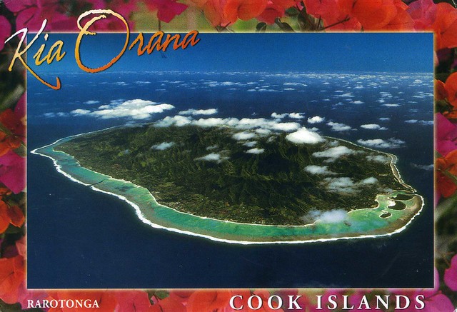
Just one more card for today.. but this last card is quite a treat - it's from the Cook Islands, and actually mailed directly from there! I have my postcard pal Sharon from Australia to thank for this treat; she visited Cook Islands this summer and kindly sent me a postcard from there.


The Cook Islands is a self-governing parliamentary democracy in free association with New Zealand. The 15 small islands in this South Pacific Ocean country have a total land area of 240 square kilometres, but the Cook Islands Exclusive Economic Zone (EEZ) covers 1,800,000 square kilometres of ocean.

The Cook Islands are in the South Pacific Ocean, north-east of New Zealand, between French Polynesia and American Samoa. There are 15 major islands, divided into two distinct groups: the Southern Cook Islands, and the Northern Cook Islands of coral atolls.

The islands were formed by volcanic activity; the northern group is older and consists of six atolls (sunken volcanoes topped by coral growth). The climate is moderate to tropical.

The main population centres are on the island of Rarotonga (14,153 (census 2006), out of the country's total population of 19,569), where there is an international airport. The chief town, Avarua, on the north coast of Rarotonga, is also the capital of the Cook Islands.

With about 100,000 visitors travelling to the islands in the 2010-11 financial year, tourism is the country's main industry, and the leading element of the economy, far ahead of offshore banking, pearls, and marine and fruit exports.

Defence and foreign affairs are the responsibility of New Zealand, in consultation with the Cook Islands. In recent times, the Cook Islands have adopted an increasingly independent foreign policy. Although Cook Islanders are citizens of New Zealand, they have the status of Cook Islands nationals, which is not given to all New Zealand citizens.


The stamp is from a set of 18 definitives issued in 2010, all depicting flowers.

Armenian Monastic Ensembles of Iran

Another official from earlier this year, this one is also one of my very few postcards from Iran. ...and it's a Unesco site as well!


IR-4594


The Armenian Monastic Ensembles of Iran, in the north-west of the country, consists of three monastic ensembles of the Armenian Christian faith: St Thaddeus and St Stepanos and the Chapel of Dzordzor. (The one on this card is St Stepanos.) These edifices - the oldest of which, St Thaddeus, dates back to the 7th century – are examples of outstanding universal value of the Armenian architectural and decorative traditions. They bear testimony to very important interchanges with the other regional cultures, in particular the Byzantine, Orthodox and Persian. Situated on the south-eastern fringe of the main zone of the Armenian cultural space, the monasteries constituted a major centre for the dissemination of that culture in the region. They are the last regional remains of this culture that are still in a satisfactory state of integrity and authenticity. Furthermore, as places of pilgrimage, the monastic ensembles are living witnesses of Armenian religious traditions through the centuries. Source.


The stamps on the right are definitives issued in 2009, while the stamp on the left is also a definitive, issued in 2010 and possibly from a set of 4 (?) stamps depicting fish.

autumn in Austria

Ha! The weather reports were wrong, thank goodness, and it didn't snow here. It has actually been reasonably warm - I haven't had to use my hotwater bottle too many times yet :p I haven't been to West Park to take photos yet, I really need to go at some point.. Meanwhile, here's a pretty autumnal postcard to look at. :)


AT-73531


I have no idea of the exact location of the place on this card, all I know is that it's supposedly a random location somewhere in Austria. ..and such a beautiful place it is, too! I love the colours here, the contrast of the oranges and yellows with the blue of the lake and the mountains (?).


The stamp is a Europa stamp from 2009, that year's theme being 'astronomy'.