Slovenia seems like SUCH a beautiful country, it would be wonderful to get to visit it one day. A Finnish friend of mine, Keiju, got to visit it earlier this summer and treated me to this GLORIOUS postcard (the top one; the second one is from a swap with Europa stamps). Apparently it's always raining at Bled! Just look at these stunning views, though!
Lake Bled is a lake in the Julian Alps of the Upper Carniolan region of northwestern Slovenia, where it adjoins the town of Bled. The area is a tourist destination. The lake is 35 km from Ljubljana International Airport and 55 km from the capital city, Ljubljana.
The lake is of mixed glacial and tectonic origin. It is 2,120 m long and 1,380 m wide, with a maximum depth of 29.5 m, and it has a small island. The lake lies in a picturesque environment, surrounded by mountains and forests. Medieval Bled Castle stands above the lake on the north shore and has a museum. The Zaka Valley lies at the west end of the lake. The World Rowing Championships in 1966, 1979, 1989, and 2011 were held at Lake Bled.
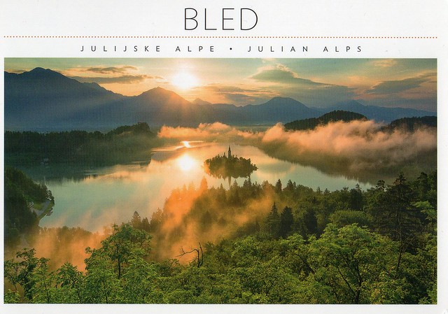
The lake surrounds Bled Island (Blejski otok). The island has several buildings, the main one being the pilgrimage church dedicated to the Assumption of Mary (Cerkev Marijinega vnebovzetja), built in its current form near the end of the 17th century, and decorated with remains of Gothic frescos from around 1470 in the presbyterium and rich Baroque equipment. The church has a 52 m tower and there is a Baroque stairway dating from 1655 with 99 stone steps leading up to the building. The church is frequently visited and weddings are held there regularly. Traditionally it is considered good luck for the groom to carry his bride up the steps on the day of their wedding before ringing the bell and making a wish inside the church.
^The stamp on Keiju's card. We were both wondering if this is a real stamp as the image is so blurry?!?
^...and the stamps on the second card. How beautiful are they?! Once again I'm annoyed at the Royal Mail for not issuing a Europa stamp this year. Why, WHY are they not interested in participating??
Showing posts with label swap. Show all posts
Thursday, 25 July 2019
Sunday, 26 August 2018
Greetings from Kyrgyzstan
I'm starting to lose interest with this series a bit... the cards all seem so alike no and it seems like there's not much effort put into them, although that could just be me... although it does depress me that a lot of senders can't be bothered to write anything other than 'greetings from x country' on their card.
I don't even know what else to write about this card... apart from the fact that I bet there aren't 80 ACTIVE Postcrossing members in Kyrgyzstan, something that has always frustrated me about this series.
Engelsberg Ironworks, Sweden
Not moving very far with this card... This is from a swap with Doris in Sweden earlier this month.
Ecomuseum Bergslagen (Swedish: Ekomuseum Bergslagen) is an open-air museum in the western part of the former mining and smelting region of Bergslagen in central Sweden. The museum opened in 1986 and is today the world's largest ecomuseum. The museum is a joint project of the municipalities Ludvika, Smedjebacken, Fagersta, Norberg, Skinnskatteberg, Surahammar and Hallstahammar. Two provincial museums in Dalarna and Västmanland County participate in the project. Ecomuseum Bergslagen is a 750 square kilometre area reaching from Lake Mälaren in the south to Forest Finns forests in the north. It takes about three hours by car to travel from north to south and the visitors travel on their own through the landscape. About 60 sites describe how human beings have used the region's natural resources to survive over time. The history of production of iron is the theme of the museum. Bergslagen was once the most important iron area in Sweden.
You can follow the history of mining for more than 2000 years – from 400 BC until today. Ekomuseum Bergslagen shows mythical pre-historic ironwork sites with historical blast furnacees and smithy, rolling mills, and modern steel businesses along the vital transportation route, the Strömsholms Canal. But also castles, such as Strömsholm Palace, workers' homes in Ludvika and Grängesberg and Forest Finns simple settlements and cottages near Grangärde. The museum includes several mining areas, local museums, electric power stations, historical railways (Engelsberg-Norberg Railway), and a historical railway museum (Railway museum Grängesberg). One of the attractions is Lapphyttan in Norberg Municipality, may be regarded as the type site for the Medieval Blast Furnace. Its date is probably between 1150 and 1350. It produced cast iron, which was then fined to make ferritic wrought iron cake or bun-like blooms. Another attraction is Engelsberg Ironworks (Swedish: Engelsbergs bruk), an ironworks in Ängelsberg. It was built in 1681 and is listed as a UNESCO world heritage site since 1993.
Thursday, 12 July 2018
Palace and Gardens of Schönbrunn, Austria
One more for today... another swap from last year and also a Unesco card with a Europa stamp and gorgeous special cancellations. :) Thank you so much, Marco!
From the 18th century to 1918, Schönbrunn was the residence of the Habsburg emperors. It was designed by the architects Johann Bernhard Fischer von Erlach and Nicolaus Pacassi and is full of outstanding examples of decorative art. Together with its gardens, the site of the world’s first zoo in 1752, it is a remarkable Baroque ensemble and a perfect example of Gesamtkunstwerk.
.
Guimarães, Portugal
Just a couple of other random cards for today... This one is from a swap from last year. I was actually able to collect some Europa stamps then as the Royal Mail decided to issue one as well and I was able to offer a Europa stamp for swap. This year, once again, the Royal Mail haven't bothered :(
The exceptionally well preserved Historic Centre of Guimarães, located in the northern Portugal district of Braga, is often referred to as the cradle of the Portuguese nationality. The history of Guimarães is closely associated with the creation of the national identity and language of Portugal. The city was the feudal territory of the Portuguese Dukes who declared the independence of Portugal in the mid-12th century.
Founded in the 4th century, Guimarães became the first capital of Portugal in the 12th century. Its historic centre is an extremely well preserved and an authentic example of the evolution of a medieval settlement into a modern town, its rich building typology exemplifying the specific development of Portuguese architecture from the 15th to the 19th centuries through the consistent use of traditional building materials and techniques. This variety of different building types documents the responses to the evolving needs of the community. A particular type of construction developed here in the Middle Ages was used widely in the then Portuguese colonies. It featured a ground floor in granite with a half-timbered structure above, a technology that was transmitted to Portuguese colonies in Africa and the New World, becoming their characteristic feature.
The Historic Centre of Guimarães is distinguished in particular for the integrity of its historically authentic building stock. Examples from the period from 950 to 1498 include the two anchors around which Guimarães initially developed, the castle in the north and the monastic complex in the south. The period from 1498 to 1693 is characterized by noble houses and the development of civic facilities, city squares, etc. While there have been some changes during the modern era, the historic centre of Guimarães has maintained its medieval urban layout. The continuity in traditional technology and the maintenance and gradual change have contributed to an exceptionally harmonious townscape.
What do you know about the USA
Long time no see... I hadn't realised it's been over a year since my last update. Ooops... I don't think I'll ever catch up with this, as even if I have the time, most of the time I'm not in the mood for doing this.
Anyway... I've started collecting a new postcard series. I wasn't going to, but I think these water colours are really pretty and the cards are really nice. I'm posting this one now mainly because I'll be going to the USA myself later this year. :) I'll be going to Orlando, Florida for 10 days in October and very much looking forward to it, although I'm also a little nervous as I've never been outside of Europe before. It should be interesting, though. I'm not too keen on Disney but I definitely want to visit the Universal Studios - and travel on the Hogwarts Express ;)
This card is from a swap with Julia earlier this year. She added a little bit of information on the back of the card as well, about the Four Corners Monument. It is the only place in the US where four states intersect: Arizona, New Mexico, Utah and Colorado. You can stand on that spot and truly be in four states at one time.
Monday, 8 May 2017
Greetings from Latvia
What does it say about this series that they aren't always even checked properly before going for printing, like here - one of the 'famous Latvians' is listed twice?! Unless I'm very much mistaken, a corrected issue was published later.. I've pretty much given up on trying to get the new issues as well because they all seem to be such hard-to-get countries and I'm not willing to pay ridiculous amounts for mint stamps/extra cards etc. Oh well, it was fun while it lasted. ....and I should still be getting the new special edition Finland card as I managed to arrange a swap for it. :)
This one is from a swap from two years ago.
I tried to find more information about this apparently very famous Arvīds Blūmentāls but Wikipedia doesn't have any information about them in English. ...and I'm too lazy to comment on anything else. :P
This one is from a swap from two years ago.
I tried to find more information about this apparently very famous Arvīds Blūmentāls but Wikipedia doesn't have any information about them in English. ...and I'm too lazy to comment on anything else. :P
Sunday, 1 May 2016
Greetings from Slovakia
Slovakia seems to be in the same category as South Africa in my postcard collection - I only have a few cards from there as well. This card is from an Instagram swap from last year.
Slovakia, officially the Slovak Republic, is a landlocked country in Central Europe. It is bordered by the Czech Republic and Austria to the west, Poland to the north, Ukraine to the east and Hungary to the south. Slovakia's territory spans about 49,000 square kilometres and is mostly mountainous. The population is over 5 million and comprises mostly ethnic Slovaks. The capital and largest city is Bratislava. The official language is Slovak, a member of the Slavic language family.
The Slavs arrived in the territory of present-day Slovakia in the 5th and 6th centuries. In the 7th century, they played a significant role in the creation of Samo's Empire and in the 9th century established the Principality of Nitra. In the 10th century, the territory was integrated into the Kingdom of Hungary, which itself became part of the Habsburg Empire and the Austro-Hungarian Empire. After World War I and the dissolution of the Austro-Hungarian Empire, the Slovaks and Czechs established Czechoslovakia. A separate Slovak Republic (1939–1945) existed in World War II as a client state of Nazi Germany. In 1945, Czechoslovakia was reestablished under communist rule as a Soviet satellite. Slovakia became an independent state on 1 January 1993 after the peaceful dissolution of Czechoslovakia.
Slovakia is a high-income advanced economy. The country joined the European Union in 2004 and the Eurozone on 1 January 2009. Slovakia is also a member of the Schengen Area, NATO, the United Nations, the OECD and the WTO.
The Postcrossing Association of Finland
A really interesting postcard I received last year. Not really so much the picture on it, but the story behind it and the reason for the card. Things like this make me miss Finland. :P
It seems fairly safe to say that Postcrossing is still pretty big in Finland when they now have a Postcrossing Association (Suomen Postcrossing-yhdistys). They have their own website (as far as I can tell, it's only in Finnish, though) and they seem fairly active. I'm pretty sure I'd be a member, too, if I still lived in Finland.
This card was sent from the association's constituent meeting, but it seems to have a been a meet-up as well as the card was signed by quite a few people.
Durban, South Africa
I only have a handful of postcards from South Africa so when I got a chance to swap earlier this year, I just couldn't say no. ...and it's nice to see something other than wild animals here :)
Durban is the largest city in the South African province of KwaZulu-Natal. After Johannesburg, the Durban Metropolitan Area ranks second among the most populous urban areas in South Africa, virtually ex-aequo with Cape Town. It is also the second most important manufacturing hub in South Africa after Johannesburg. It forms part of the eThekwini Metropolitan Municipality. Durban is famous for being the busiest port in South Africa. It is also seen as one of the major centres of tourism because of the city's warm subtropical climate and extensive beaches. The municipality, which includes neighbouring towns, has a population of almost 3.5 million, making the combined municipality one of the biggest cities on the Indian Ocean coast of the African continent. The metropolitan land area of 2,292 square kilometres is comparatively larger than other South African cities, resulting in a somewhat lower population density of 1,513/km2. It has the highest number of dollar millionaires added per year of any South African city with the number rising 200% between 2000 and 2014.
In May 2015, Durban was officially recognized as one of the New7Wonders Cities together with Vigan, Doha, La Paz, Havana, Beirut, and Kuala Lumpur.
Archaeological Heritage of the Lenggong Valley, Malaysia
I've got a bit of a random mix of cards for today. This one is from a swap from last year.
Situated in the lush Lenggong Valley, the property includes four archaeological sites in two clusters which span close to 2 million years, one of the longest records of early man in a single locality, and the oldest outside the African continent. It features open-air and cave sites with Palaeolithic tool workshops, evidence of early technology. The number of sites found in the relatively contained area suggests the presence of a fairly large, semi-sedentary population with cultural remains from the Palaeolithic, Neolithic and Metal ages.
Saturday, 30 April 2016
Alice in Wonderland and another Russian Postcrossing stamp
I had no idea the Russian post had issued ANOTHER Postcrossing stamp until someone posted an offer on the Postcrossing forum and obviously I couldn't resist. :P So many countries seem to be issuing Postcrossing stamps now, I wonder if there's a list or something of upcoming releases in other countries? I'm sure the Dutch post will be issuing a second set as well, or have they already done that?? I haven't been very active in Postcrossing recently and haven't sent that many cards for a while. It's just too expensive, and it doesn't help that stamp prices went up in the UK recently.
Anyway, thank you so much for swapping, Elena!
I know the postcard isn't Postcrossing-related or even a viewcard.. but I've got a bit of a soft spot for Alice in Wonderland, and I love seeing different illustrations from different countries. The artist here is named Oksana Vostrikova.
Anyway, thank you so much for swapping, Elena!
I know the postcard isn't Postcrossing-related or even a viewcard.. but I've got a bit of a soft spot for Alice in Wonderland, and I love seeing different illustrations from different countries. The artist here is named Oksana Vostrikova.
Labels:
2016,
cancellations,
illustrations,
postcrossing,
russia,
stamps,
swap
Sunday, 3 April 2016
Greetings from New Zealand
Just one more card for today, a 'greetings from' one from New Zealand.
Mentioning the Lord of the Rings movie trilogy was probably a very obvious choice here?? I do love the trilogy, they are some of my all-time favourite movies and I still remember when they came out and the anticipation for the next film... and then the extended edition dvd boxes and all the extras on those and watching them with friends. It almost got to the point where the extras were my favourite part :D Most dvds/blue rays still don't come anywhere close. Ahhh, good times! I'm getting nostalgic here... :p
I do wonder why the kiwi fruit isn't mentioned here.. but at least the sheep are included! ;)
Helsinki, Finland
A lovely snowy view from Finland I received last year. I love the atmosphere here, it seems magical somehow.. and cozy at the same time.
The picture is from the Kruununhaka neighbourhood in southern Helsinki. It's one of the more affluent, fancy areas of Helsinki. According to Wikipedia, the area is known for its vintage shops??!
I LOVE the stamp! It was kind of why this swap got arranged in the first place... :D
The picture is from the Kruununhaka neighbourhood in southern Helsinki. It's one of the more affluent, fancy areas of Helsinki. According to Wikipedia, the area is known for its vintage shops??!
I LOVE the stamp! It was kind of why this swap got arranged in the first place... :D
Saturday, 26 March 2016
Complex of Hué Monuments, Vietnam
A lovely Unesco card from Vietnam I received a couple of years ago.
The Complex of Hue Monuments is located in and around Hue City in Thua Thien-Hue Province in the geographical centre of Vietnam and with easy access to the sea. Established as the capital of unified Vietnam in 1802 CE, Hue was not only the political but also the cultural and religious centre under the Nguyen Dynasty, the last royal dynasty of Vietnamese history, from 1802 to 1945 CE.
The plan of the new capital is in accordance with ancient oriental philosophy, and respected the physical conditions of the site.
The Ngu Binh Mountain (known as the Royal Screen) and the Perfume River, which runs through the city, give this unique feudal capital an entire setting of great natural beauty as well defining its symbolic importance. The site was chosen for a combination of natural features – hills representing a protective screen in front of the monuments or taking the role of “a blue dragon” to the left and “a white tiger” to the right – which shield the main entrance and prevent the entry of malevolent spirits. Within this landscape, the main features of the city are laid out.
The structures of the Complex of Hue Monuments are carefully placed within the natural setting of the site and aligned cosmologically with the Five Cardinal Points (centre, west, east, north, south), the Five Elements (earth, metal, wood, water, fire), and the Five Colours (yellow, white, blue, black, red).
Greetings from Malaysia
Now, I honestly thought I'd already posted about this card in this blog. Turns out I haven't... hhmmmm. I ended up receiving two copies of this card, too, and I'll include the stamps of both of them here as they are both really nice, and one of them has really nice decorations on the back as well. I kind of wish I had that much inspiration when writing my cards!
Matthew points out that Malaysia is the only country that has land on both mainland Asia and Malay archipelago. It does make for a pretty interesting map!
I also love the bit about multiracial society here. I was talking to my parents in Finland yesterday and some of the things we discussed made me pretty sad. I'd already read some of it in the news and just can't believe some people would be so horrible. Some Finns (and other nationals) could learn a thing or a few from Malaysia!
The stamps on the first card (from Matthew)...
...and the back of the second card. Isn't this lovely?!
Thursday, 24 March 2016
Tusi Sites, China
Tusi Sites is the most recent Unesco site in China. I received this postcard from a swap last year.
Distributed around the mountainous areas of south-west China are the remains of tribal domains whose leaders were appointed by the central government as ‘Tusi’, hereditary rulers of their regions from the 13th to the early 20th century. This system of administrative government was aimed at unifying national administration while simultaneously allowing ethnic minorities to retain their customs and way of life. The three sites of Laosicheng, Tangya and the Hailongtun Fortress combine as a serial property to represent this system of governance. The archaeological sites and standing remains of Laosicheng Tusi Domain and Hailongtun Fortress represent domains of highest ranking Tusi; the Memorial Archway and remains of the Administration Area, boundary walls, drainage ditches and tombs at Tangya Tusi Domain represent the domain of a lower ranked Tusi. Their combinations of local ethnic and central Chinese features exhibit an interchange of values and testify to imperial Chinese administrative methods, while retaining their association with the living cultural traditions of the ethnic minority groups represented by the cultural traditions and practices of the Tujia communities at Laosicheng.
Sunday, 13 March 2016
Temple of Preah Vihear, Cambodia
Today seems to be all about postcards I received in 2015. :P It really wasn't intentional, I always just tend to pick a few random cards from a pile I've put aside that I want to blog about. Anyway, this was quite a treat as well and I was really happy when Ave agreed to swap with me. It's not like I receive postcards from Cambodia every other week. :P
Situated on the edge of a plateau that dominates the plain of Cambodia, the Temple of Preah Vihear is dedicated to Shiva. The Temple is composed of a series of sanctuaries linked by a system of pavements and staircases over an 800 metre long axis and dates back to the first half of the 11th century AD. Nevertheless, its complex history can be traced to the 9th century, when the hermitage was founded. This site is particularly well preserved, mainly due to its remote location. The site is exceptional for the quality of its architecture, which is adapted to the natural environment and the religious function of the temple, as well as for the exceptional quality of its carved stone ornamentation.
Tarangire National Park, Tanzania
Yet another postcard from last year. I think this is only about my second postcard received from Tanzania, sent by Xindi who was volunteering in Tanzania. It must have been quite an experience...!
Tarangire National Park is the sixth largest national park in Tanzania after Ruaha, Serengeti, Mikumi, Katavi and Mkomazi. The national park is located in Manyara Region. The name of the park originates from the Tarangire river that crosses through the park, being the only source of water for wild animals during dry seasons. During the dry season thousands of animals migrate to the Tarangire National Park from Manyara National Park.
It lies a little distance to the south east of Lake Manyara and covers an area of approximately 2,850 square kilometers. The landscape and vegetation is incredibly diverse with a mix that is not found anywhere else in the northern safari circuit. The hilly landscape is dotted with vast numbers of Baobab trees, dense bush and high grasses.
The park is famous for its huge number of elephants, baobab trees and tree climbing lions. Visitors to the park can expect to see any number of resident zebra and wildebeest in addition to the less common animals. Other common animals include waterbuck, giraffe, and olive baboons.
Home to more than 550 species, the park is a haven for bird enthusiasts who can expect so see dozens of species even in the dry season. The swamps are the focus of the largest selection of breeding birds anywhere in the world. yellow-collared lovebirds are a common bird sighting in the trees along the Tarangire River.
The park is also famous for the termite mounds that dot the landscape. Those that have been abandoned are often seen to be home to dwarf mongoose.
In 2015, a giraffe that is white due to leucism was spotted in the park.
Kiev Pechersk Lavra, Ukraine
Another postcard from last year. This is a Unesco site, too, but I love it more for its colours and the atmosphere - and there's a Postcrossing stamp and a special cancellation on it, and those were actually the main point of this card. Postcrossing stamps are such a cool idea, I wish the Royal Mail would issue one as well but apparently they won't even consider it. :( ...and the Netherlands are going to get a SECOND set later this month!
Kyiv Pechersk Lavra, also known as the Kiev Monastery of the Caves, is a historic Orthodox Christian monastery which gave its name to one of the city districts where it is located in Kiev.
Since its foundation as the cave monastery in 1051 the Lavra has been a preeminent center of Eastern Orthodox Christianity in Eastern Europe. Together with the Saint Sophia Cathedral, it is inscribed as a UNESCO World Heritage Site. The monastery complex is considered a separate national historic-cultural preserve (sanctuary), the national status to which was granted on 13 March 1996. The Lavra is not only located in another part of the city, but is part of a different national sanctuary than Saint Sophia Cathedral. While being a cultural attraction, the monastery is currently active. It was named one of the Seven Wonders of Ukraine on 21 August 2007, based on voting by experts and the internet community.
Subscribe to:
Posts (Atom)