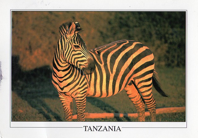
Yet another postcard from last year. I think this is only about my second postcard received from Tanzania, sent by Xindi who was volunteering in Tanzania. It must have been quite an experience...!
Tarangire National Park is the sixth largest national park in Tanzania after Ruaha, Serengeti, Mikumi, Katavi and Mkomazi. The national park is located in Manyara Region. The name of the park originates from the Tarangire river that crosses through the park, being the only source of water for wild animals during dry seasons. During the dry season thousands of animals migrate to the Tarangire National Park from Manyara National Park.
It lies a little distance to the south east of Lake Manyara and covers an area of approximately 2,850 square kilometers. The landscape and vegetation is incredibly diverse with a mix that is not found anywhere else in the northern safari circuit. The hilly landscape is dotted with vast numbers of Baobab trees, dense bush and high grasses.
The park is famous for its huge number of elephants, baobab trees and tree climbing lions. Visitors to the park can expect to see any number of resident zebra and wildebeest in addition to the less common animals. Other common animals include waterbuck, giraffe, and olive baboons.
Home to more than 550 species, the park is a haven for bird enthusiasts who can expect so see dozens of species even in the dry season. The swamps are the focus of the largest selection of breeding birds anywhere in the world. yellow-collared lovebirds are a common bird sighting in the trees along the Tarangire River.
The park is also famous for the termite mounds that dot the landscape. Those that have been abandoned are often seen to be home to dwarf mongoose.
In 2015, a giraffe that is white due to leucism was spotted in the park.
Showing posts with label africa. Show all posts
Sunday, 13 March 2016
Tuesday, 9 February 2016
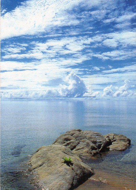
Lake Malawi, Malawi
This is my first written and stamped postcard received from Malawi! It's one of those postcards I never expected to receive. Well, pretty much all African countries are like that to me... :p
Lake Malawi, also known as Lake Nyasa in Tanzania and Lago Niassa in Mozambique, is an African Great Lake and the southernmost lake in the East African Rift system, located between Malawi, Mozambique and Tanzania. It is the ninth largest lake in the world and the third largest and second deepest lake in Africa. It is home to more species of fish than any other lake, including about 1000 species of cichlids. The Mozambique portion of the lake was officially declared a reserve by the Government of Mozambique on June 10, 2011, and in Malawi a portion of the lake is included in the Lake Malawi National Park. Lake Malawi is a meromictic lake; permanent stratification and the oxic-anoxic boundary are maintained by moderately small chemical and thermal gradients.
Lake Malawi National Park is a Unesco site, but I have no idea whether the picture on this postcard is from there. Any help would be appreciated!
Tuesday, 3 March 2015
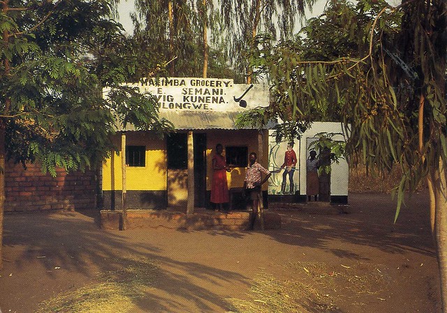
village store, Malawi
I'm not usually all that much into unwritten postcards, but I do like this one from Malawi. I love this sort of views, plus it's not like the likelihood of ever receiving a written and stamped postcard from Malawi is very big.
Malawi is a landlocked country in southeast Africa that was formerly known as Nyasaland. It is bordered by Zambia to the northwest, Tanzania to the northeast, and Mozambique on the east, south and west. The country is separated from Tanzania and Mozambique by Lake Malawi. Malawi is over 118,000 km2 with an estimated population of 16,777,547 (July 2013 est.). Its capital is Lilongwe, which is also Malawi's largest city; the second largest is Blantyre and the third is Mzuzu. The name Malawi comes from the Maravi, an old name of the Nyanja people that inhabit the area. The country is also nicknamed "The Warm Heart of Africa".
The area of Africa now known as Malawi was settled by migrating Bantu groups around the 10th century. Centuries later in 1891 the area was colonized by the British. In 1953 Malawi, then known as Nyasaland, became part of the semi-independent Central African Federation (CAF). The Federation was dissolved in 1963, and in 1964, Nyasaland gained full independence and was renamed Malawi. Upon gaining independence it became a single-party state under the presidency of Hastings Banda, who remained president until 1994, when he lost an election. Prof. Peter Mutharika is the current president. Malawi has a democratic, multi-party government. Malawi has a small military force that includes an army, a navy and an air wing. Malawi's foreign policy is pro-Western and includes positive diplomatic relations with most countries and participation in several international organisations.
Malawi is among the world's least-developed countries. The economy is heavily based in agriculture, with a largely rural population. The Malawian government depends heavily on outside aid to meet development needs, although this need (and the aid offered) has decreased since 2000. The Malawian government faces challenges in building and expanding the economy, improving education, health care, environmental protection, and becoming financially independent. Malawi has several programs developed since 2005 that focus on these issues, and the country's outlook appears to be improving, with improvements in economic growth, education and healthcare seen in 2007 and 2008.
Malawi has a low life expectancy and high infant mortality. There is a high prevalence of HIV/AIDS, which is a drain on the labour force and government expenditures. There is a diverse population of native peoples, Asians and Europeans, with several languages spoken and an array of religious beliefs. Although there was periodic regional conflict fuelled in part by ethnic divisions in the past, by 2008 it had diminished considerably and the concept of a Malawian nationality had re-emerged. Malawian cultural practices and Malawian cuisine are rich in local, southern African, and overseas influences, as well as this, they have many peculiar forms of cuisine found no where else. These include eating ants, honey soaked beetles and a type of native fish which is dried, baked in spices and then soaked in goat milk and various leaves for up to two days creating a type of tea flavored jerky, though this is only prevalent in rural areas within small communities.
Malawi is a landlocked country in southeast Africa that was formerly known as Nyasaland. It is bordered by Zambia to the northwest, Tanzania to the northeast, and Mozambique on the east, south and west. The country is separated from Tanzania and Mozambique by Lake Malawi. Malawi is over 118,000 km2 with an estimated population of 16,777,547 (July 2013 est.). Its capital is Lilongwe, which is also Malawi's largest city; the second largest is Blantyre and the third is Mzuzu. The name Malawi comes from the Maravi, an old name of the Nyanja people that inhabit the area. The country is also nicknamed "The Warm Heart of Africa".
The area of Africa now known as Malawi was settled by migrating Bantu groups around the 10th century. Centuries later in 1891 the area was colonized by the British. In 1953 Malawi, then known as Nyasaland, became part of the semi-independent Central African Federation (CAF). The Federation was dissolved in 1963, and in 1964, Nyasaland gained full independence and was renamed Malawi. Upon gaining independence it became a single-party state under the presidency of Hastings Banda, who remained president until 1994, when he lost an election. Prof. Peter Mutharika is the current president. Malawi has a democratic, multi-party government. Malawi has a small military force that includes an army, a navy and an air wing. Malawi's foreign policy is pro-Western and includes positive diplomatic relations with most countries and participation in several international organisations.
Malawi is among the world's least-developed countries. The economy is heavily based in agriculture, with a largely rural population. The Malawian government depends heavily on outside aid to meet development needs, although this need (and the aid offered) has decreased since 2000. The Malawian government faces challenges in building and expanding the economy, improving education, health care, environmental protection, and becoming financially independent. Malawi has several programs developed since 2005 that focus on these issues, and the country's outlook appears to be improving, with improvements in economic growth, education and healthcare seen in 2007 and 2008.
Malawi has a low life expectancy and high infant mortality. There is a high prevalence of HIV/AIDS, which is a drain on the labour force and government expenditures. There is a diverse population of native peoples, Asians and Europeans, with several languages spoken and an array of religious beliefs. Although there was periodic regional conflict fuelled in part by ethnic divisions in the past, by 2008 it had diminished considerably and the concept of a Malawian nationality had re-emerged. Malawian cultural practices and Malawian cuisine are rich in local, southern African, and overseas influences, as well as this, they have many peculiar forms of cuisine found no where else. These include eating ants, honey soaked beetles and a type of native fish which is dried, baked in spices and then soaked in goat milk and various leaves for up to two days creating a type of tea flavored jerky, though this is only prevalent in rural areas within small communities.
Meknes, Morocco
A wonderful Unesco card from Morocco that I received last year. I was supposed to receive another card from the same person as well but that never arrived.. I'm kind of wondering whether they just forgot to send it or what happened there, but I wasn't very happy... :/ Anyway, Meknes is one of the so-called "King Cities" in Morocco.
The Historic City of Meknes has exerted a considerable influence on the development of the civil and military architecture (the kasbah) and works of art. Founded in 1061 A.D. by the Almoravids as a military stronghold, its name originates from the great Berber tribe Meknassa who dominated eastern Morocco as far back as the Tafilalet in the 8th century. Geographically, it is remarkably located in the Saïss Plain between the Middle Atlas and the pre-rifan massif of Zerhoun. It contains the vestiges of the Medina that bears witness to ancient socio-economic fabric and the imperial city created by the Sultan Moulay Ismail (1672-1727). It is the presence today of this historic city containing the rare remains and important monuments located within a rapidly changing urban environment that gives this urban heritage its universal value. The two ensembles are surrounded by a series of ramparts that separate them from one another. In addition to its architectural interest of being built in the Hispano-Moorish style, Meknes is of particular interest as it represents the first great work of the Alaouite dynasty, reflecting the grandeur of its creator. It also provides a remarkable approach of urban design, integrating elements of both Islamic and European architecture and town planning.
Behind the high defensive walls, pierced by nine monumental gates, are key monuments including twenty-five mosques, ten hammams, palaces, vast graneries, vestiges of fondouks (inns for merchants) and private houses, testimonies to the Almoravid, Merinid and Alaouite Periods.
Sunday, 1 March 2015
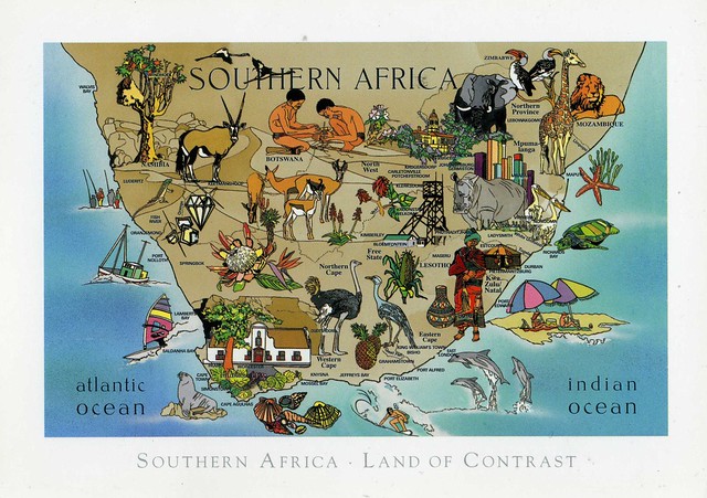
South Africa map
A lovely South Africa map card I received some years ago. I still don't have too many postcards from South Africa...
South Africa, officially the Republic of South Africa (RSA), is a country located in Southern Africa. It has 2,798 kilometres of coastline that stretches along the South Atlantic and Indian oceans. To the north lie the neighbouring countries of Namibia, Botswana and Zimbabwe; to the east are Mozambique and Swaziland; and within it lies Lesotho, an enclave surrounded by South African territory. South Africa is the 25th-largest country in the world by land area, and with close to 53 million people, is the world's 25th-most populous nation.
South Africa is a multiethnic society encompassing a wide variety of cultures, languages, and religions. Its pluralistic makeup is reflected in the constitution's recognition of 11 official languages, which is among the highest number of any country in the world. Two of these languages are of European origin: Afrikaans developed from Dutch and serves as the first language of most white and coloured South Africans, based on history. Though English is commonly used in public and commercial life, it is fourth-ranked as a spoken first language.
About 80 percent of South Africans are of black sub-Saharan African ancestry, divided among a variety of ethnic groups speaking different Bantu languages, nine of which have official status. The remaining population consists of Africa's largest communities of European (white), Asian (Indian), and multiracial (coloured) ancestry. Since 1994, all ethnic and linguistic groups have had political representation in the country's constitutional democracy, which comprises a parliamentary republic and nine provinces. South Africa is often referred to as the "Rainbow Nation," a term coined by Archbishop Desmond Tutu and later adopted by then-President Nelson Mandela as a metaphor to describe the country's newly developing multicultural diversity in the wake of segregationist apartheid ideology.
The country is one of the few in Africa never to have had a coup d'état, and regular elections have been held for almost a century. But the vast majority of black South Africans were not enfranchised until 1994. During the 20th century, the black majority sought to recover its rights from the dominant white minority, with this struggle playing a large role in the country's recent history and politics. The National Party imposed apartheid in 1948, institutionalizing previous racial segregation. After a long and sometimes violent struggle by the African National Congress and other anti-apartheid activists, Discriminatory laws began to be repealed or abolished from 1990 onwards.
South Africa is ranked as an upper-middle income economy by the World Bank, and is considered to be a newly industrialised country. Its economy is the second-largest in Africa, and the 34th-largest in the world. In terms of purchasing power parity, South Africa has the seventh-highest per capita income in Africa. But poverty and inequality remain widespread, with about a quarter of the population unemployed and living on less than US$1.25 a day. Nevertheless, South Africa has been identified as a middle power in international affairs, and maintains significant regional influence.
Saturday, 13 December 2014
Miradouro de Leba, Huila, Angola
A new country to my collection! Well, this one wasn't actually mailed from Angola but since the chances of ever receiving a postcard from there are pretty slim, I'm more than happy with this one. It's such a nice view, too!
Angola, officially the Republic of Angola, is a country in Southern Africa. It is the seventh largest country in Africa, and is bordered by Namibia on the south, the Democratic Republic of the Congo on the north, and Zambia on the east; its west coast is on the Atlantic Ocean and Luanda is its capital city. The exclave province of Cabinda has borders with the Republic of the Congo and the Democratic Republic of the Congo.
The Portuguese were present in some – mostly coastal – points of the territory of what is now Angola, from the 16th to the 19th century, interacting in diverse ways with the peoples who lived there. In the 19th century, they slowly and hesitantly began to establish themselves in the interior. Angola as a Portuguese colony encompassing the present territory was not established before the end of the 19th century, and "effective occupation", as required by the Berlin Conference (1884) was achieved only by the 1920s after the Mbunda resistance and abduction of their King, Mwene Mbandu I Lyondthzi Kapova. Independence was achieved in 1975, after a protracted liberation war. After independence, Angola was the scene of an intense civil war from 1975 to 2002. Despite the civil war, areas such as Baixa de Cassanje continue a lineage of kings which have included the former King Kambamba Kulaxingo and current King Dianhenga Aspirante Mjinji Kulaxingo.
The country has vast mineral and petroleum reserves, and its economy has on average grown at a double-digit pace since the 1990s, especially since the end of the civil war. In spite of this, standards of living remain low for the majority of the population, and life expectancy and infant mortality rates in Angola are among the worst in the world. Angola is considered to be economically disparate, with the majority of the nation's wealth concentrated in a disproportionately small sector of the population.
Angola is a member state of the United Nations, OPEC, African Union, the Community of Portuguese Language Countries, the Latin Union and the Southern African Development Community.
Huíla, then, is a province of Angola. It has an area of 79,023 square kilometres and a population of 2,354,398 (2014 census). Lubango is the capital of the province. Basket-making is a significant industry in the province; many make baskets out of reeds.
Thursday, 23 August 2012
Ivory Coast
One more postcard for today... and what a cool card it is! Ivory Coast is one of those places I never thought I'd ever receive a postcard from. Seems I can be lucky sometimes, then! :)
Ivory Coast (officially Côte d'Ivoire) is a country in West Africa. It has an area of 322,462 square kilometres, and borders the countries Liberia, Guinea, Mali, Burkina Faso and Ghana; its southern boundary is along the Gulf of Guinea. The country's population was 15,366,672 in 1998 and was estimated to be 20,617,068 in 2009.
Ivory Coast is a republic with a strong executive power invested in the President. Its de jure capital is Yamoussoukro and the biggest city is the port city of Abidjan. The official language is French, although many of the local languages are widely used, including Baoulé, Dioula, Dan, Anyin and Cebaara Senufo. The main religions are Islam, Christianity (primarily Roman Catholic) and various indigenous religions.
Through production of coffee and cocoa, the country was an economic powerhouse during the 1960s and 1970s in West Africa. However, Ivory Coast went through an economic crisis in the 1980s, leading to the country's period of political and social turmoil. The 21st century Ivoirian economy is largely market-based and relies heavily on agriculture, with smallholder cash crop production being dominant.
Thursday, 8 March 2012
Ngorongoro Crater, Tanzania
One more card for today, from a pretty different location. It's not like I receive postcards from Africa all the time.. Last year I found a thread on the Postcrossing forum about donating some money to a charity called 'Hearts in Unity' and then receiving a postcard from Tanzania as a thank you. I couldn't resist the offer, and the money went to a good cause anyway. This pretty postcard arrived in December.

The United Republic of Tanzania is a country in East Africa bordered by Kenya and Uganda to the north, Rwanda, Burundi, and the Democratic Republic of the Congo to the west, and Zambia, Malawi, and Mozambique to the south. The country's eastern border lies on the Indian Ocean.
Tanzania is a state composed of 26 regions (mikoa), including those of the semi-autonomous region of Zanzibar. The head of state is President Jakaya Mrisho Kikwete, elected in 2005. Since 1996, the official capital of Tanzania has been Dodoma, where Parliament and some government offices are located. Between independence and 1996, the main coastal city of Dar es Salaam served as the country's political capital. Today, Dar es Salaam remains the principal commercial city of Tanzania and the de facto seat of most government institutions. It is the major seaport for the country and its landlocked neighbours.
The picture on this postcard shows the Ngorongoro Crater. It is located in the Ngorongoro Conservation Area (NCA),a conservation area and a UNESCO World Heritage Site situated 180 km west of Arusha in the Crater Highlands area of Tanzania. The conservation area is administered by the Ngorongoro Conservation Area Authority, an arm of the Tanzanian government, and its boundaries follow the boundary of the Ngorongoro Division of Ngorongoro District.
Saturday, 21 May 2011
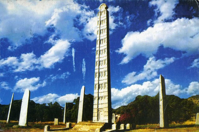
Aksum, Ethiopia
One more card for today, then I'll be back to making my ninja cookies :D This card is also from a new country: Ethiopia! It was kindly sent to me by Sean who was recently staying in Ethiopia. It sounds like he had a really good time there, too - you can read more about his travels here.

This postcard shows the ruins of the ancient city of Aksum, also a Unesco World Heritage Site, found close to Ethiopia's northern border. They mark the location of the heart of ancient Ethiopia, when the Kingdom of Aksum was the most powerful state between the Eastern Roman Empire and Persia. The massive ruins, dating from between the 1st and the 13th century A.D., include monolithic obelisks, giant stelae, royal tombs and the ruins of ancient castles. Long after its political decline in the 10th century, Ethiopian emperors continued to be crowned in Aksum. [source]

The stamp on the right is from a set of 23 definitives issued in 2000, representing animals. I'm not sure of the other stamps as it says it was issued in 2002 but I'm guessing it's a definitive as well.
Saturday, 5 February 2011
Nigeria
A new country! Yeah, this is my first postcard received from Nigeria. Thank you so much for the swap, Irina!

Irina told me that it's really difficult to find viewcards in Nigeria, but I don't mind receiving this, it's always great to see people and traditions in different countries. ...and judging by the number of Nigerian postcrossers, it doesn't look like postcards are hugely popular over there anyway.
This postcard shows 'Nigerian Cultural Dance'. Irina says that Nigerians, in general, like dancing and singing. She prefers the traditional dancing to the modern dancing. I don't know anything about either (and couldn't find much information on them either) so I can't really comment, but I reckon they have different purposes anyway so it would be a bit harsh to compare. I'd just like to say that the ladies on this card are very pretty! :)

The stamp on the left is from 2009 and commemorates the World Cup in South Africa, and the stamp on the right is from a set of 8 definitives issued in 2001, showing animals. This one here is the Red-eared Guenon.
Wednesday, 8 September 2010
Sousse, Tunisia
One more post about an African country, this time Tunisia.


I won't write much about Sousse here as I've already done so here. I couldn't resist posting more cards of the place, though, because I find it so fascinating. I could probably spend days on the alleys of the Medina, taking photos and just looking at all the gorgeous buildings and little details. Mmmmmm...!
Liubov of Russia who sent me these cards, wrote this on the back of one of the cards:
Tunisia was a French colony until 1956. French is a second official language. Most of the population are Arabs, 95% Muslims. Women in Tunisia have equal rights with men. Allowed divorce and polygamy is forbidden. Absolutely officially operate brothels under state control. In general Tunisia is poor but rather prosperous tourist country where everything is under total control of the state.
This is quite topical, then, seeing as most of the population of Tunisia are muslims and Ramadan is about to finish this year. It's such an interesting concept, I've been reading a bit more about it this year as there have been posts about it in one of my favourite blogs recently.
Morocco
A wonderful map card that came from a swap with Naomi who was visiting Morocco.

This is my first written and stamped postcard from Morocco as well. I have a few more now, thanks to Naomi, but this one is so lovely, I really do like map cards. It's so much fun to discover new places! It also reminds me a bit of the famous Finnish board game "Afrikan tähti" ("the star of Africa"). Tangiers is one of the starting places in the game so that name is particularly familiar to me.
It always confuses me how near Morocco is to Spain. It's so close, and yet so far away. Morocco really fascinates me and I'd love to visit the country one day. The architecture there seems gorgeous, as does the culture in general, and the cuisine is very tempting, mmmmmm... And I'd love to taste Moroccan mint tea. :)

I couldn't find any info on the stamp, but it looks like it's from a set of definitive stamps issued in 2008, depicting Moroccan tapestries.
Ghana
Another swap card, from the lovely Helen in the USA.

Helen told me she was supposed to go with her college friend to Ghana, but decided against it at the last minute as she's already used up so many vacation days. I wish I could say the same personally... *sigh* I'd really love to travel more and see a bit more of the world, but there's no way I could afford that. Postcards are a nice substitute, though (and books!).
I don't know anything about the place shown on this card, except that it's quite obviously an open air market. Looks really nice, too! A little bit about the country...:
The Republic of Ghana is a country located in West Africa. It is bordered by Côte d'Ivoire (Ivory Coast) to the west, Burkina Faso to the north, Togo to the east, and the Gulf of Guinea to the south. Ghana was inhabited in pre-colonial times by a number of ancient predominantly Akan Kingdoms, including the Akwamu on the eastern coast, the inland Ashanti Empire and various Fante and non-Akan states, like the Ga and Ewe, along the coast and inland. Trade with European states flourished after contact with the Portuguese in the 15th century, and the British established the Gold Coast Crown colony in 1874.
The Gold Coast achieved independence from the United Kingdom in 1957, becoming the first sub-Saharan African nation to do so and the name Ghana was chosen for the new nation to reflect the ancient Empire of Ghana, which once extended throughout much of west Africa. Ghana is a member of the South Atlantic Peace and Cooperation Zone, the Commonwealth of Nations, the Economic Community of West African States, the African Union, and an associate Member of La Francophonie. Ghana is the second largest producer of cocoa in the world and is also home to Lake Volta, the largest artificial lake in the world by surface area.

This postcard was mailed from the USA, too. Here are two more stamps from the "Sunday Funnies" issue from earlier this year, and a definitive stamp "American Clock".
Saturday, 7 August 2010
Sousse, Tunisia
Staying by the Mediterranean (and old cards)... This one is actually a German official card, but sent from Tunisia during the sender's holiday there. I know there are people who don't really like it when the postcard code and the country on the card don't match, but I don't mind, especially when the card has been sent from holidays. I think it's a brilliant idea, especially as it seems like people don't send so many cards from their holidays anymore.

DE-376397
Sousse is located 140 km south of the capital Tunis, in the central-east of the country, on the Gulf of Hammamet, which is a part of the Mediterranean Sea. Its economy is based on transport equipment, processed food, olive oil, textiles and tourism.
Sousse is considered one of the best examples of seaward-facing fortifications built by the Arabs. Its ribat, a soaring structure that combined the purposes of a minaret and a watch tower, is in outstanding condition and draws visitors from around the world.
These days, Sousse, with a population of more than 540,000, retains a medieval heart of narrow, twisted streets, a kasbah and medina, its ribat fortress and long wall on the Mediterranean. Surrounding it is a modern city of long, straight roads and more widely spaced buildings. The medina is also a Unesco World Heritage Site.
I'm not 100 % sure, but it looks like the author of this amazing blog lives in Sousse, or at least it looks an awful lot like Sousse. (The last couple of weeks she's been on holiday in Finland, but the majority of photos there are from Tunisia, and they are AMAZING. That blog is amongst my favourites.) It's really made me want to visit this beautiful country, if only I had more money to travel... *sigh*

The stamp is very pretty. It's from a set of 4 stamps issued in 2008 regarding Terracotta Objects, this one here being terracotta dish Kairouan.
Subscribe to:
Posts (Atom)


Maroon