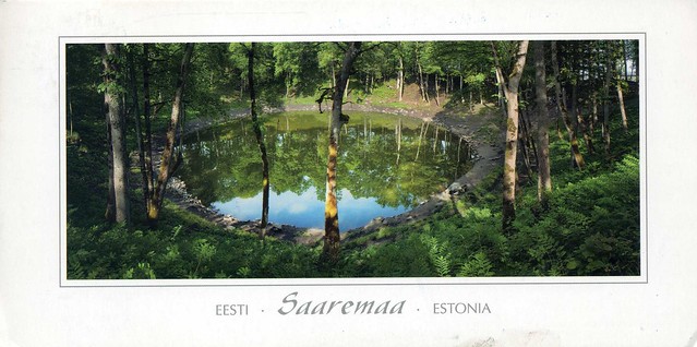
Kaali is a group of 9 meteorite craters located on the Estonian island of Saaremaa. Formed in the 7th century BC, it is one of the most recent craters created by an impact event and the only known major impact event that has occurred in a populated area. Prior to the 1930s, the main crater was thought to have been a volcanic caldera. Its meteoritic origins were first conclusively demonstrated by Ivan Reinvald in 1937.
Saaremaa, then, is the largest island in Estonia, measuring 2,673 km². The main island of Saare County, it is located in the Baltic Sea, south of Hiiumaa island, and belongs to the West Estonian Archipelago. The capital of the island is Kuressaare, which has about 15,000 inhabitants; the whole island has over 39,000 inhabitants.
The island forms the main barrier between the Gulf of Riga and the Baltic Sea. To the south of it is the main passage out of the gulf, the Irbe Strait, next to Sõrve Peninsula, the southernmost portion of the island. In Medieval times islanders were crossing the strait to form fishing villages on Livonian coast, in particular Pitrags village. In those days it was easier and quicker to cross the strait towards nearby Kolka, Saunags or Mazirbe, than travel by horse large distances inland. The highest point on the island is 54 m above sea level. The island has lots of forested terrain. One of the symbols of the island is the juniper.

The stamp is from a mini sheet issued earlier this year, showing the peony.


 Maroon


")


No comments:
Post a Comment