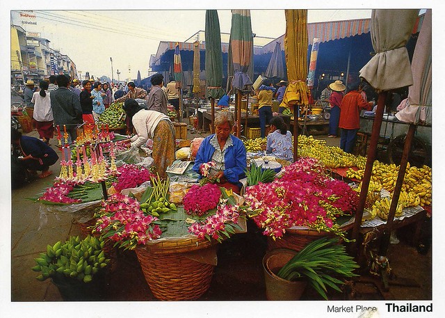
Today's last card is from dear Heather. I love market scenes like this, so pretty and colourful!
This is an early morning scene at a market in Surin, a town in Thailand, capital of Surin province. It is the site of the annual Surin Elephant Round-up. As of 2000, Surin had a population of 41,582.
Heather mailed the card from Australia. I just love Australian stamps and these are no exception.
Saturday, 28 February 2015
Greetings from Japan
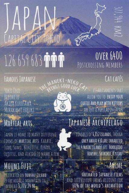
Today's 'Greetings from' postcard comes from Japan. This was a bit of an awkward swap, too - I sent the 'Greetings from' United Kingdom postcard in return to Michelle, but it was taking ages to arrive so we both assumed it had got lost and I sent another one in the hopes that that one would arrive. ...and a few days after posting the second card, the first one arrived! Well, I did receive a gorgeous Dayan the Cat postcard from Michelle as well so I'm not really complaining too much...!
This is one of my favourite postcards in this series. I love the colours and the little maneki-neko illustration, and it also helps that the postcard mentions Haruki Murakami, quite possibly my favourite author, and Aikido, a martial art I've been practicing since 2005 and am currently a 2nd dan black belt in. ...and I have a soft spot for Japan in general and would very much love to visit the country one day. I only just realised as well that Mount Fuji is a Unesco site, so this is another card for that collection of mine. :)
The beauty of the solitary, often snow-capped, stratovolcano, known around the world as Mount Fuji, rising above villages and tree-fringed sea and lakes has long been the object of pilgrimages and inspired artists and poets. The inscribed property consists of 25 sites which reflect the essence of Fujisan’s sacred and artistic landscape. In the 12th century, Fujisan became the centre of training for ascetic Buddhism, which included Shinto elements. On the upper 1,500-metre tier of the 3,776m mountain, pilgrim routes and crater shrines have been inscribed alongside sites around the base of the mountain including Sengen-jinja shrines, Oshi lodging houses, and natural volcanic features such as lava tree moulds, lakes, springs and waterfalls, which are revered as sacred. Its representation in Japanese art goes back to the 11th century, but 19th century woodblock prints of views, including those from sand beaches with pine tree groves have made Fujisan an internationally recognized icon of Japan and have had a deep impact on the development of Western art.
A sushi stamp!! *heart*
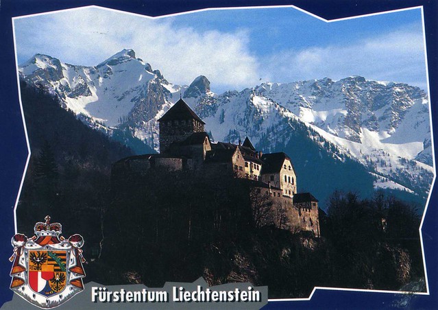
Vaduz Castle, Liechtenstein
I think this is only my second postcard from Liechtenstein, and quite possibly the only written and stamped one. For some reason I don't seem to have posted the other one here so here's the written and stamped one.
Vaduz Castle is the palace and official residence of the Prince of Liechtenstein. The castle gave its name to the town of Vaduz, the capital of Liechtenstein, which it overlooks from an adjacent hilltop.
Liechtenstein, officially the Principality of Liechtenstein, is a doubly landlocked German-speaking microstate in Central Europe. It is a constitutional monarchy headed by the Prince of Liechtenstein.
Liechtenstein is bordered by Switzerland to the west and south and Austria to the east and north. It has an area of just over 160 square kilometres and an estimated population of 35,000. Divided into 11 municipalities, its capital is Vaduz and largest town Schaan.
Economically, Liechtenstein has the highest gross domestic product per person in the world when adjusted by purchasing power parity. It is also the 2nd richest (by measure of GDP per capita) country in the world, after Qatar, and has one of the lowest unemployment rates at 1.5%.
An alpine country, Liechtenstein is mainly mountainous, making it a winter sports destination. Many cultivated fields and small farms are found both in the south (Oberland, upper land) and north (Unterland, lower land). The country has a strong financial sector centered in Vaduz, and has been identified as a tax haven. It is a member of the European Free Trade Association and part of the European Economic Area and the Schengen Area, but not of the European Union.
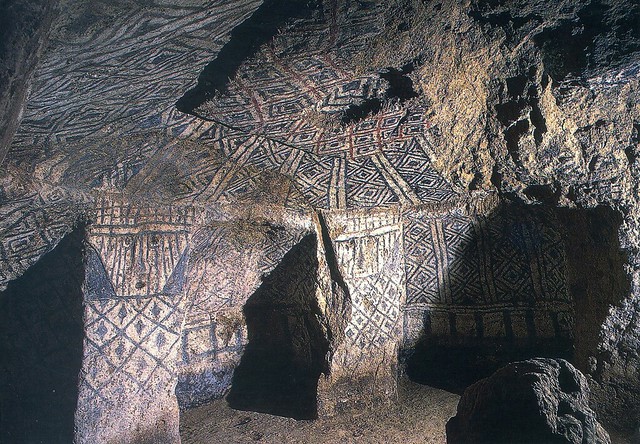
National Archeological Park of Tierradentro, Colombia
Another Unesco card... I just realised all three I've just posted here were received in 2013. That was not intentional :P
Tierradentro is a National archeological park in the jurisdiction of the municipality of Inza, Department of Cauca, Colombia. The park is located 100 km away from the capital of the Department, Popayán.
The area is very well known for its pre-Columbian hypogea, which were found in several excavations, and are divided in many archeological places. some of them are: Alto del Aguacate (Avocado Hill), Alto de San Andrés, Alto de Segovia, Alto del Duende and El Tablón.
The typical hypogeum has an entry oriented towards the west, a spiral staircase and a main chamber, usually 5 to 8 meters below the surface, with several lesser chambers around, each one containing a corpse. The walls are painted with geometric, anthropomorphic and zoomorphic patterns in red, black and white. Some statues and remains of pottery and fabrics can be seen scarcely due to grave robbery before the hypogea were constituted as protected areas.
The pre-Columbian culture that created this funeral complex inhabited this area during the first millennium A.C. Tierradentro Archaeological park features hypogea dating from 6th to 9th centuries AD. The details in the sculptures and pictoric patterns are similar to the San Agustín culture.
The park generates significant revenue to the local economy due to the high volume of tourists, both Colombian and foreigners. These sites form a UNESCO World Heritage Site. The site was listed on the World Monuments Fund's 2012 World Monuments Watch list of 100 Most Endangered Sites.
This card was sent from Germany, hence the German stamps.
Gracanica Monastery, Kosovo
Another Unesco card, this time from Kosovo. This arrived from a swap with Sini of Finland. I think this is only my second or so postcard from Kosovo as well. Gracanica Monastery is one of the Medieval Monuments in Kosovo.
Gračanica is a Serbian Orthodox monastery located in Kosovo. It was rebuild by the Serbian king Stefan Milutin in 1321 on the ruins of a 6th-century early Christian three-naved basilica. Gračanica Monastery was declared Monument of Culture of Exceptional Importance in 1990, and it is protected by Republic of Kosovo and considered as protected monument by Republic of Serbia because of the unaccepted self declared independence of Kosovo, and on 13 July 2006 it was placed on UNESCO's World Heritage List under the name of Medieval Monuments in Kosovo as an extension of the Visoki Dečani site which was overall placed on the List of World Heritage in Danger.
The Gračanica Monastery is one of King Milutin's last monumental endowments. It is situated in the village of Gračanica, a Serb enclave 5 km (3.1 mi) from Pristina. The monastery is in the close vicinity of Lipljan (ancient Roman town of Ulpiana), the old residence of bishops.
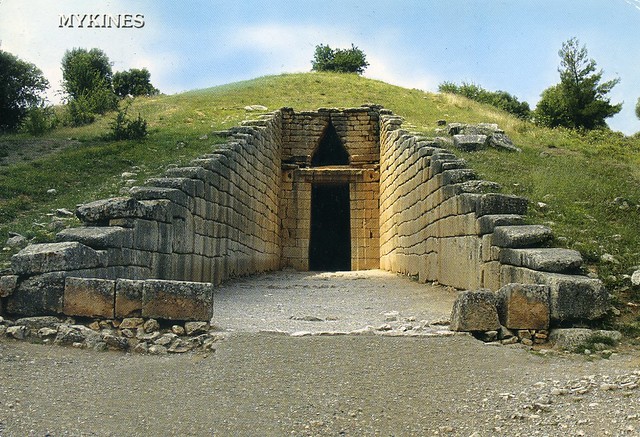
Archaeological Site of Mycenae, Greece
I don't have too many Unesco postcards from Greece... Well, here's one! It's part of the Archaeological Sites of Mycenae and Tiryns.
Mycenae and Tiryns represent the apogee of the Mycenaean civilization, which laid the foundations for the evolution of later European cultures, including classical Greek architecture and urban design, and consequently also on contemporary cultural forms. Moreover, the two sites are indissolubly linked with the Homeric epics, the Iliad and the Odyssey, the influence of which upon European literature and the arts has been profound for more than three millennia.
The Mycenaean civilization developed on the Greek mainland in the late Bronze Age (16th century BC). It was essentially a continuation of the Middle Helladic culture, transformed by Minoan influences from Crete. Knowledge of its two earlier periods I (c . 1580-1500 BC) and II (c . 1500-1400 BC) comes mainly from burials, notably the shaft graves at Mycenae. Towards the end of Period II more elaborate tomb types developed - large chamber tombs for families and beehive-shaped (tholos) tombs for royalty. The apogee of the Mycenaean civilization came in Period III (c . 1400-1120 BC), when strong citadels and elaborate palaces were built. Towards the end of this period a script, known as Linear B, came into use; the language used has been shown to be an early form of Greek, confirming that the Mycenaeans were Greek speakers of Indo-European origin. The political structure was that of an autocratic monarchy, the ruler of which was known as the wanax, who administered his territory by means of a hierarchical structure of officials. There was a special class of priests and priestesses. The people were organized in an elaborate class system, and slavery was widely practised.
The site of Mycenae is known from excavations to have been occupied from the Neolithic period (c . 4000 BC). During the Middle Helladic period a cemetery was established on the southern slopes of the natural hill which included Grave Circle B (dated to the 17th century BC) and Grave Circle A (16th century BC). The Palace was constructed on the summit of the hill and surrounded by massive cyclopean walls in three stages (c . 1350, 1250 and 1225 BC respectively). In the final stage the underground reservoir was also fortified. A series of tholos tombs were built on the southern and south-western slopes of the hill during the Mycenaean period: the so-called Tomb of Aegisthos (c. 1500 BC), the Lion Tholos Tomb (c. 1350 BC), the Tomb of Clytemnestra (c. 1220 BC), culminating in the Treasury of Atreus, at some distance from the others. Four large buildings, believed to have been royal workshops, were built in the 13th century BC in the vicinity of Grave Circle B. The palace was abandoned at the end of the 12th century BC and a number of buildings were damaged by fire. However, the site continued to be occupied until 498 BC, when it was conquered by Argos and its inhabitants were expelled. The top of the hill was levelled at this time for the construction of an Archaic temple. The site was reoccupied briefly in the Hellenistic period, when another temple was built and a theatre constructed over the Tomb of Clytemnestra. By the time the Greek traveller Pausanias visited Mycenae in the 2nd century AD it had been completely abandoned for many years.
Saturday, 21 February 2015
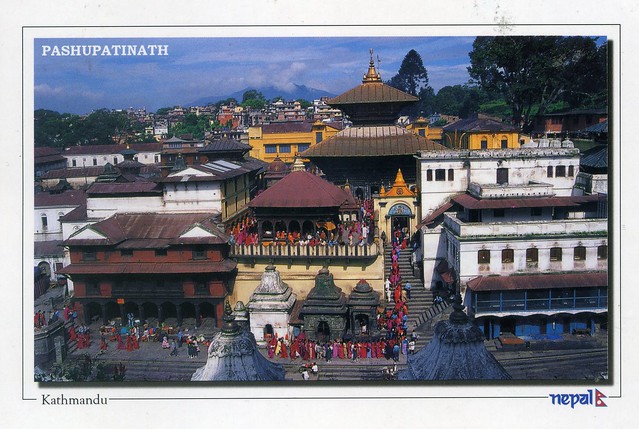
Pashupatinath Temple, Nepal
This is an interesting one. Chiayu of Taiwan messaged me last year, asking whether I'd be interested in swapping postcards as she was going to Nepal for a while. Of course I was interested! :) I was really surprised about her message, though - normally people want something a lot harder to get than what I can usually offer if they are offering postcards from somewhere like Nepal. Well, it certainly was a nice surprise!
The gold roofed Pashupatinath Temple is from the 5th century AD, dedicated to Lord Shiva and a Unesco world heritage site as well as one of the holiest shrines for Hindus. It is part of the cultural heritage of the Kathmandu Valley. The cultural heritage of the Kathmandu Valley is illustrated by seven groups of monuments and buildings which display the full range of historic and artistic achievements for which the Kathmandu Valley is world famous. The seven include the Durbar Squares of Hanuman Dhoka (Kathmandu), Patan and Bhaktapur, the Buddhist stupas of Swayambhu and Bauddhanath and the Hindu temples of Pashupati and Changu Narayan.
Chiayu used a matching stamp :)
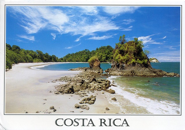
Manuel Antonio National Park, Costa Rica
A lovely swap card from Costa Rica, again from 2013 (that wasn't intentional...).
Manuel Antonio National Park, in Spanish the Parque Nacional Manuel Antonio, is a small National Park in the Central Pacific Conservation Area located on the Pacific coast of Costa Rica, just south of the city of Quepos, Puntarenas, and 132 km from the national capital of San José. Established in 1972 with a land area enumerating 1 983 ha (the smallest of any Costa Rican national park), it is the destination of as many as 150,000 visitors annually and well known for its beautiful beaches and hiking trails. In 2011, Manuel Antonio was listed by Forbes among the world's 12 most beautiful national parks.
Manuel Antonio National Park, in Spanish the Parque Nacional Manuel Antonio, is a small National Park in the Central Pacific Conservation Area located on the Pacific coast of Costa Rica, just south of the city of Quepos, Puntarenas, and 132 km from the national capital of San José. Established in 1972 with a land area enumerating 1 983 ha (the smallest of any Costa Rican national park), it is the destination of as many as 150,000 visitors annually and well known for its beautiful beaches and hiking trails. In 2011, Manuel Antonio was listed by Forbes among the world's 12 most beautiful national parks.
Amish Country, USA
I seem to remember there was a documentary series on TV here last (?) year about the Amish. I didn't watch too much of it but I did find it kind of interesting. I've got a couple of postcards about the Amish, one an official and one that I received as part of a swap so I thought I'd include them both here. The first one is from Pennsylvania and the second one from Indiana.
US-194987
The Amish are a group of traditionalist Christian church fellowships, closely related to but distinct from Mennonite churches, with whom they share Swiss Anabaptist origins. The Amish are known for simple living, plain dress, and reluctance to adopt many conveniences of modern technology. The history of the Amish church began with a schism in Switzerland within a group of Swiss and Alsatian Anabaptists in 1693 led by Jakob Ammann. Those who followed Ammann became known as Amish.
In the early 18th century, many Amish and Mennonites immigrated to Pennsylvania for a variety of reasons. Today, the most traditional descendants of the Amish continue to speak Pennsylvania German, also known as "Pennsylvania Dutch". However, a dialect of Swiss German predominates in some Old Order Amish communities, especially in the American state of Indiana. As of 2000, over 165,000 Old Order Amish live in the United States and about 1,500 live in Canada. A 2008 study suggested their numbers have increased to 227,000, and in 2010 a study suggested their population had grown by 10 percent in the past two years to 249,000, with increasing movement to the West.
Amish church membership begins with baptism, usually between the ages of 16 and 25. It is a requirement for marriage, and once a person has affiliated with the church, he or she may marry only within the faith. Church districts average between 20 and 40 families, and worship services are held every other Sunday in a member's home. The district is led by a bishop and several ministers and deacons. The rules of the church, the Ordnung, must be observed by every member and cover most aspects of day-to-day living, including prohibitions or limitations on the use of power-line electricity, telephones, and automobiles, as well as regulations on clothing. Most Amish do not buy commercial insurance or participate in Social Security. As present-day Anabaptists, Amish church members practice nonresistance and will not perform any type of military service.
Amish children in straw hats and bonnets are a common sight during school days in Northern Indiana Amish Country. One room Amish schoolhouses dot the countryside along the 90-mile Heritage Trail audio tour route.
Labels:
2008,
2009,
amish country,
indiana,
officials,
pennsylvania,
people,
swap,
usa
Rome, Italy & Sovereign Military Order of Malta
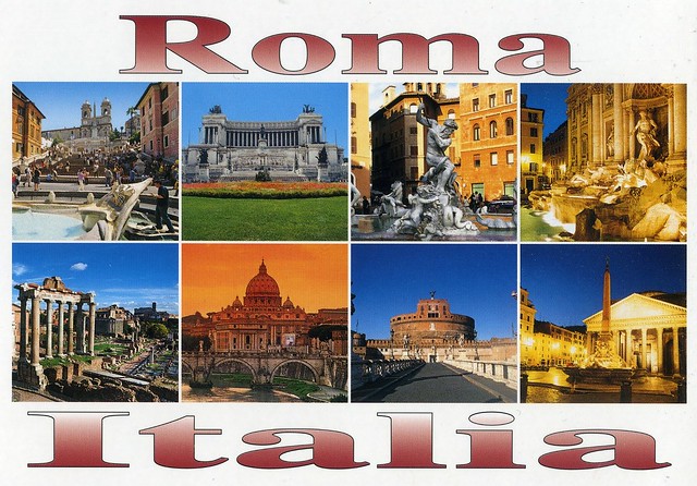
Another swap card from a couple of years ago. I know the postcard is a pretty regular touristy multiview of Rome, but the main focus here is the stamp and the cancellation. Luca offered postcards with the Sovereign Military Order of Malta stamps and cancellations, and I got curious, although I had never heard of this order before.
The Sovereign Military Hospitaller Order of Saint John of Jerusalem of Rhodes and of Malta, also known as the Sovereign Military Order of Malta (SMOM), Order of Malta or Knights of Malta, is a Roman Catholic lay religious order of, traditionally, a military, chivalrous and noble nature. It is the world's oldest surviving order of chivalry. The Sovereign Military Order of Malta is headquartered in Rome, Italy, and is widely considered a sovereign subject of international law.
SMOM is the modern continuation of the original medieval order of Saint John of Jerusalem, known as the "Fraternitas Hospitalaria" and later as the Knights Hospitaller, a group founded in Jerusalem around the year 1050 as an Amalfitan hospital to provide care for poor and sick pilgrims to the Holy Land. After the conquest of Jerusalem in 1099 during the First Crusade, it became a military order under its own charter. Following the loss of Christian held territories of the Holy Land to Muslims, the order operated from Rhodes (1310–1523), and later from Malta (1530–1798), over which it was sovereign.
Although this state came to an end with the ejection of the order from Malta by Napoleon Bonaparte, the order as such survived. It retains its claims of sovereignty under international law and has been granted permanent observer status at the United Nations. The order is notable for issuing its own international passports for travel, postal stamps, along with its formal insignia, often portrayed as a white or gold Maltese cross. The order nominally invokes the Blessed Virgin Mary under the venerated Marian title of "Our Lady of Mount Philermos" as its patroness and spiritual intercessor.
Today the order has about 13,000 members; 80,000 permanent volunteers; and 20,000 medical personnel including doctors, nurses, auxiliaries and paramedics in more than 120 countries. The goal is to assist the elderly, handicapped, refugeed, children, homeless, those with terminal illness and leprosy in all parts of the world, without distinction of race or religion. In several countries—including France, Germany and Ireland—the local associations of the order are important providers of first aid training, first aid services and emergency medical services. Through its worldwide relief corps—Malteser International—the order is also engaged to aid victims of natural disasters, epidemics and armed conflicts.
In February 2013 the order celebrated its 900th anniversary recognising the Papal bull of sovereignty "Pie Postulatio Voluntatis" formally issued by Pope Paschal II on 15 February 1113, with a general audience given by Pope Benedict XVI and a Holy Mass celebrated by Vatican Secretary of State Cardinal Tarcisio Bertone at Saint Peter's Basilica.
SMOM has no postal agreement with the UK, or at least it didn't have at the time of sending this card, so Luca very kindly sent it to his own address first and then sent it to me in an envelope.
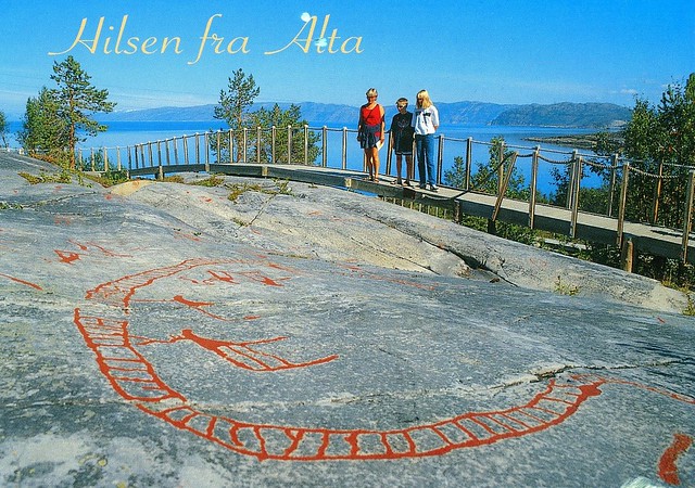
Rock Art of Alta, Norway
This card is from a swap with Joey in Norway a couple of years ago. Unfortunately Joey then disappeared from the Postcrossing forum before I could send a postcard back to him and he never answered my messages. I don't like owing cards to people. :(
The property is situated in the northernmost part of Norway, far north of the Arctic Circle at the head of the Alta Fjord. It contains thousands of rock carvings and paintings located at 45 sites in five different areas at the head of the Alta Fjord (Kåfjord, Hjemmeluft, Storsteinen, Amtmannsnes and Transfarelvdalen). More rock art made by hunter-gatherers is found in Alta than anywhere else in northern Europe. This seems to indicate that for thousands of years, from approximately 5000 B.C. to about the year 0, Alta was an important meeting place far north of the Arctic Circle. The development of carvings in Alta through thousands of years can be related to the post-glacial land upheaval. The oldest carvings are found at the highest points of the landscape. In Alta the changing landscape of prehistoric times is evident, and the position of the carvings also provides a key to understanding the chronology of rock art in the circumpolar region.
The Rock Art shows communication between the world of the living and the worlds of the spirits, and gives insight into the cosmology of prehistoric hunters and gatherers. There is an exceptionally high number of human figures and compelling portrayals of prehistoric social life, dancing, processions, and rituals. Moreover, the Rock Art provides a unique testimony to the interaction of hunter-gatherers with the landscape. The panels show hunting, fishing and boat journeys, and are thought to represent micro-landscapes. A wide range of circumpolar fauna is depicted (reindeer, elks, bears, fish, whales, seabirds, etc.). Studies of material culture are enriched by the many different artefacts shown on the Alta panels. Good preservation conditions permit the study of rock art production.
Investigation of the large settlement sites adjacent to the carvings gives a better understanding of the social context of the Rock Art. The Rock Art and the settlement sites demonstrate communication in prehistory with areas thousands of kilometres away.
Greetings from Czech Republic
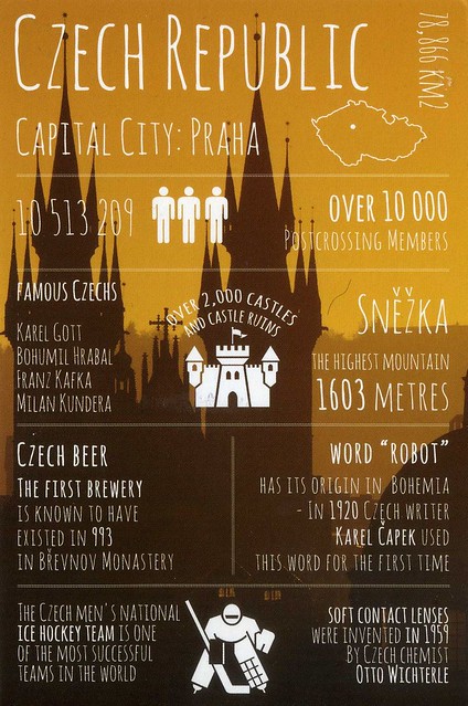
Today's 'Greetings from' postcard comes from Czech Republic, from a Facebook swap with Lenka.
I didn't know there were that many castles in Czech Republic!
I didn't know there were that many castles in Czech Republic!
Budapest, Hungary
I just realised a few days ago that I haven't posted any cards from Hungary here yet. How did that happen?? Well, here's one that I received from my friend Amanda last year from her holiday to Budapest.
Budapest is the capital and the largest city of Hungary, and one of the largest cities in the European Union. It is the country's principal political, cultural, commercial, industrial, and transportation centre, sometimes described as the primate city of Hungary. In 2011, according to the census, Budapest had 1.74 million inhabitants, down from its 1989 peak of 2.1 million due to suburbanisation. The Budapest Metropolitan Area is home to 3.3 million people. The city covers an area of 525 square kilometres within the city limits. Budapest became a single city occupying both banks of the river Danube with its unification on 17 November 1873 of Buda and Óbuda, on the west bank, with Pest, on the east bank.
Cited as one of the most beautiful cities in Europe, Budapest's extensive World Heritage Site includes the banks of the Danube, the Buda Castle Quarter, Andrássy Avenue, Heroes' Square and the Millennium Underground Railway, the second-oldest metro line in the world. It has around 80 geothermal springs, the world's largest thermal water cave system, second largest synagogue, and third largest Parliament building. The city attracts about 4.3 million tourists a year, the 25th most popular city in the world, and the 6th in Europe, according to Euromonitor.
Hungary is a landlocked country in Central Europe. It is situated in the Carpathian Basin and is bordered by Slovakia to the north, Ukraine and Romania to the east, Serbia and Croatia to the south, Slovenia to the southwest and Austria to the west. The country's capital and largest city is Budapest. Hungary is a member of the European Union, NATO, the OECD, the Visegrád Group, and the Schengen Area. The official language is Hungarian, which is the most widely spoken non-Indo-European language in Europe.
Following centuries of successive habitation by Celts, Romans, Huns, Slavs, Gepids, and Avars, the foundation of Hungary was laid in the late 9th century by the Hungarian grand prince Árpád in the Honfoglalás ("homeland-conquest"). His great-grandson Stephen I ascended to the throne in 1000 CE, converting the country to a Christian kingdom. By the 12th century, Hungary became a middle power within the Western world, reaching a golden age by the 15th century. Following the Battle of Mohács in 1526 and about 150 years of partial Ottoman occupation (1541–1699), Hungary came under Habsburg rule, and later formed a significant part of the Austro–Hungarian Empire (1867–1918).
Hungary's current borders were first established by the Treaty of Trianon (1920) after World War I, when the country lost 71% of its territory, 58% of its population, and 32% of ethnic Hungarians. Following the interwar period, Hungary joined the Axis Powers in World War II, suffering significant damage and casualties. Hungary came under the influence of the Soviet Union, which contributed to the establishment of a four-decade long communist dictatorship (1947–1989). The country gained widespread international attention regarding the Revolution of 1956 and the seminal opening of its previously-restricted border with Austria in 1989, which accelerated the collapse of the Eastern Bloc.
On 23 October 1989, Hungary again became a democratic parliamentary republic, and is today an upper-middle income country with a very high Human Development Index. Hungary is a popular tourist destination attracting 10.675 million tourists a year (2013). It is home to the largest thermal water cave system and the second largest thermal lake in the world (Lake Hévíz), the largest lake in Central Europe (Lake Balaton), and the largest natural grasslands in Europe (the Hortobágy National Park).
Friday, 20 February 2015
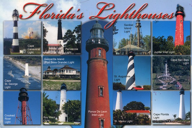
lighthouses of Florida, USA
I'm not normally too keen on receiving a viewcard from one country with stamps from another country. I didn't mind at all when I found this lovely treat in my mailbox about a year ago, however. I wouldn't normally post the back of a postcard here but I just HAVE to make an exception for this one, it's gorgeous and so creative! The sender, Andrea, actually featured in the Postcrossing blog spotlight a few months ago, with very good reason. Do read the interview, it's very inspiring!
CA-408911
I'm not sure if I already had this card in my collection... but I really don't mind! Ahhhh, and to be somewhere like Florida right now... *dreams*
So yes, the highlight of this card for me is definitely the back. So many beautiful stamps and lovely little details!
So yes, the highlight of this card for me is definitely the back. So many beautiful stamps and lovely little details!
Labels:
2014,
canada,
decorations,
florida,
lighthouses,
officials,
stamps,
usa
Ethiopia
A very nice postcard I received from Ethiopia a few years ago.
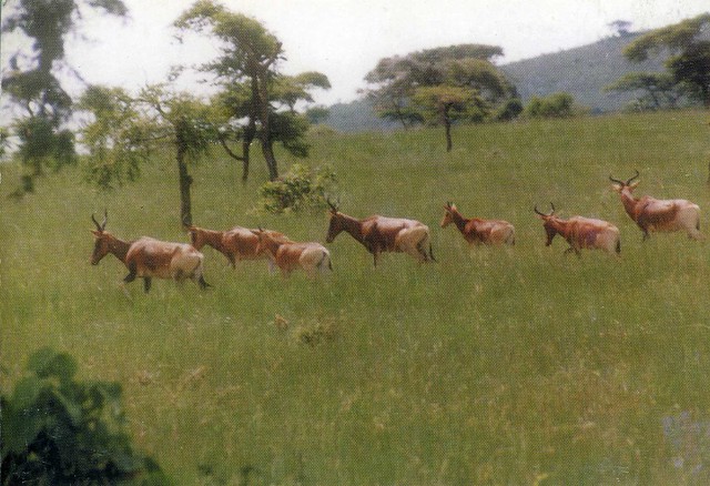
The animal here is Swayne's hartebeest, an endangered antelope native to Ethiopia. Two of the largest remaining populations are located in Senkelle Swayne's Hartebeest Sanctuary and Maze National Park.
Now, this card actually arrived from a recipe RR on the Postcrossing forum. The sender, Chitra Nair, included a recipe for 'rajma', kidney beans in yoghurt curry. I have to confess I still haven't tried it - at the time of receiving the card I didn't really like beans, but I've since learned to eat them (well, not all of them, but a lot of them anyway) so I could actually try this as it sounds quite nice. There seem to be a lot of recipes for this online, too, such as this one.
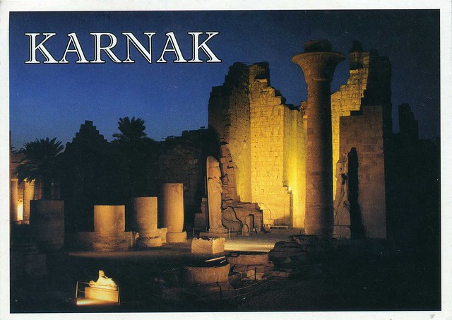
Temple of Karnak, Egypt
This nice historical view from Egypt came from a swap with Sara of Egypt a couple of years ago. It's also a Unesco site, part of the Ancient Thebes with its Necropolis.
Thebes contains the finest relics of the history, art and religion of ancient Egypt, of which it was the capital in its period of greatest splendour. Hundred of sovereigns, from pharaohs to Roman emperors, glorified the city with architecture, obelisks and sculpture. The exaltation of life found expression in the Thebes of the Living, identifiable in the fabulous site of Luxor and Karnak, on the right bank of the Nile, the site of the temples dedicated to the divine triad of Montu, Amon and Mut, while the celebration of death took shape in the Thebes of the Dead.
Thebes contains the finest relics of the history, art and religion of ancient Egypt, of which it was the capital in its period of greatest splendour. Hundred of sovereigns, from pharaohs to Roman emperors, glorified the city with architecture, obelisks and sculpture. The exaltation of life found expression in the Thebes of the Living, identifiable in the fabulous site of Luxor and Karnak, on the right bank of the Nile, the site of the temples dedicated to the divine triad of Montu, Amon and Mut, while the celebration of death took shape in the Thebes of the Dead.
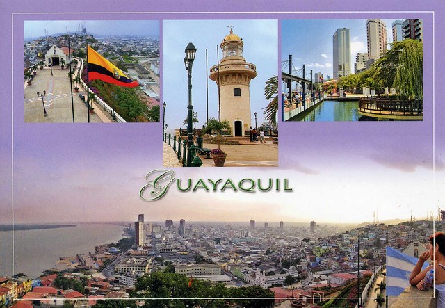
Guayaquil, Ecuador
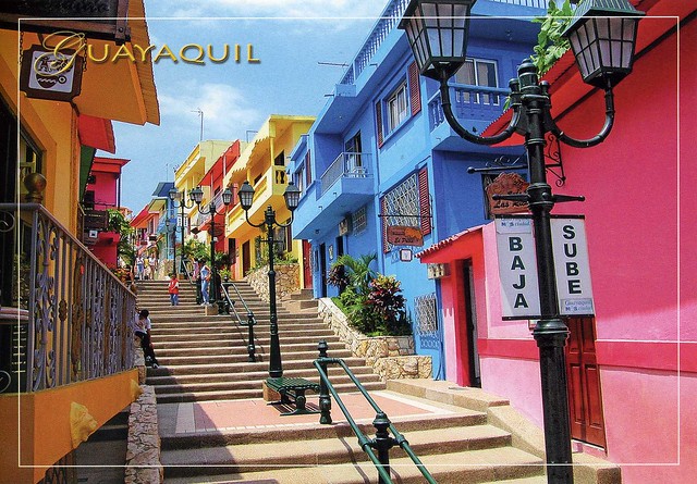
Ecuador is another country I still don't have a written and stamped postcard from, but I do have a few very nice postcards sent from other countries. ...like these two that show the city of Guayaquil. These are from a bigger swap with Jane a couple of years ago.
Guayaquil, officially Santiago de Guayaquil, is the largest and the most populous city in Ecuador, with around 2.69 million people in the metropolitan area, as well as the nation's main port. The city is the capital of the Ecuadorian province of Guayas and the seat of the namesake canton. Guayaquil is located on the western bank of the Guayas River, which flows into the Pacific Ocean at the Gulf of Guayaquil.
The postcard above shows a partial view of the city beside Guayas River, and in the smaller pictures you can see Santa Ana's Hill Chapel, lighthouse and Malecon 2000.
...and this is a famous sight from Guayaquil - Santa Ana Hill. There are 400 and something steps according to Jane - phew! She tells me people live all the way up the hill, and at the top of the hill is the Santa Ana Hill Chapel.
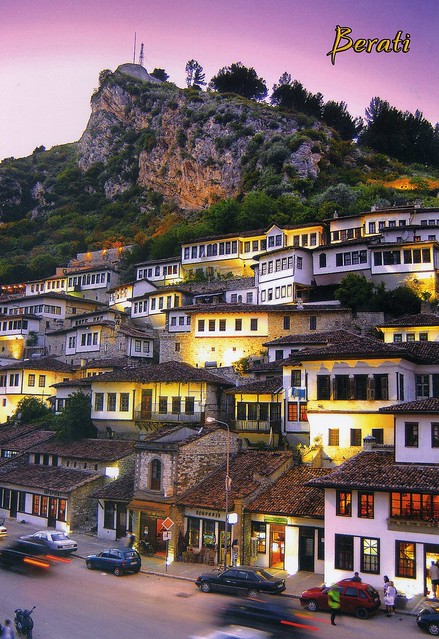
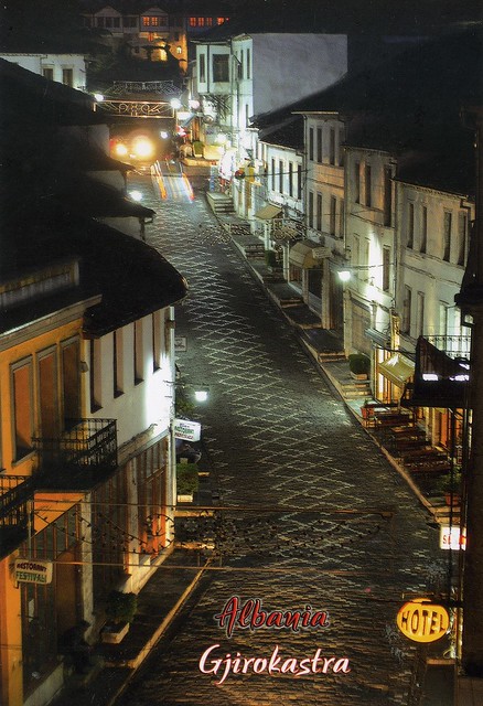
Historic Centres of Berat and Gjirokastra, Albania
I just realised the other day that Albania is the only European country in my collection that I don't have a written and stamped postcard from. Maybe one day... I did receive a few blank ones from dear Snježana a while ago. They are still pretty gorgeous. Here are two of them that also happen to show a Unesco site. Well, the first one definitely should, I'm not sure if the Gjirokastra one shows the historic centre...?? If anyone can tell me I'd appreciate the help!
Berat and Gjirokastra are inscribed as rare examples of an architectural character typical of the Ottoman period. Located in central Albania, Berat bears witness to the coexistence of various religious and cultural communities down the centuries. It features a castle, locally known as the Kala, most of which was built in the 13th century, although its origins date back to the 4th century BC. The citadel area numbers many Byzantine churches, mainly from the 13th century, as well as several mosques built under the Ottoman era which began in 1417. Gjirokastra, in the Drinos river valley in southern Albania, features a series of outstanding two-story houses which were developed in the 17th century. The town also retains a bazaar, an 18th-century mosque and two churches of the same period.
The stamps on the envelope.
Berat and Gjirokastra are inscribed as rare examples of an architectural character typical of the Ottoman period. Located in central Albania, Berat bears witness to the coexistence of various religious and cultural communities down the centuries. It features a castle, locally known as the Kala, most of which was built in the 13th century, although its origins date back to the 4th century BC. The citadel area numbers many Byzantine churches, mainly from the 13th century, as well as several mosques built under the Ottoman era which began in 1417. Gjirokastra, in the Drinos river valley in southern Albania, features a series of outstanding two-story houses which were developed in the 17th century. The town also retains a bazaar, an 18th-century mosque and two churches of the same period.
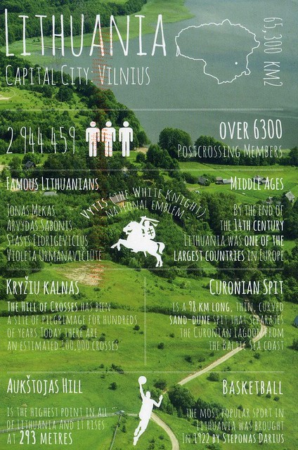
Greetings from Lithuania
Another 'Greetings from' postcard... I think this will become a regular feature from now as I really like these cards. :)
Lithuania is a country in Northern Europe, one of the three Baltic states. It is situated along the southeastern shore of the Baltic Sea, to the east of Sweden and Denmark. It is bordered by Latvia to the north, Belarus to the east and south, Poland to the south, and Kaliningrad Oblast (a Russian exclave) to the southwest. Lithuania has an estimated population of 3 million as of 2013, and its capital and largest city is Vilnius. Lithuanians are a Baltic people. The official language, Lithuanian, and Latvian are the only two living languages in the Baltic branch of the Indo-European language family.
For centuries, the southeastern shore of the Baltic Sea was inhabited by various Baltic tribes. In the 1230s, the Lithuanian lands were united by Mindaugas, the King of Lithuania, and the first unified Lithuanian state, the Kingdom of Lithuania, was created on 6 July 1253. During the 14th century, the Grand Duchy of Lithuania was the largest country in Europe; present-day Lithuania, Belarus, Ukraine, and parts of Poland and Russia were the territories of the Grand Duchy. With the Lublin Union of 1569, Lithuania and Poland formed a voluntary two-state union, the Polish–Lithuanian Commonwealth. The Commonwealth lasted more than two centuries, until neighboring countries systematically dismantled it from 1772–95, with the Russian Empire annexing most of Lithuania's territory.
As World War I neared its end, Lithuania's Act of Independence was signed on 16 February 1918, declaring the establishment of a sovereign State of Lithuania. Starting in 1940, Lithuania was occupied first by the Soviet Union and then by Nazi Germany. As World War II neared its end in 1944 and the Germans retreated, the Soviet Union reoccupied Lithuania. On 11 March 1990, a year before formal break-up of the Soviet Union, Lithuania became the first Soviet republic to declare itself independent, resulting in the restoration of an independent State of Lithuania.
Lithuania is a member of the European Union, the Council of Europe, a full member of the Schengen Agreement and NATO. It is also a member of the Nordic Investment Bank, and part of Nordic-Baltic cooperation of Northern European countries. The United Nations Human Development Index lists Lithuania as a "very high human development" country. Lithuania has been among the fastest growing economies in the European Union and is ranked 24th in the world in the Ease of Doing Business Index. On 1 January 2015, Lithuania adopted the euro as the official currency and became the 19th member of the Eurozone.
Santiago de Compostela, Spain
I'm normally at volunteering on Fridays but I'm not feeling too well - I've had a cold for a few days now, although it does seem to be getting better. It better had, too, because I'm supposed to go to the cinema with Matt and some friends on Sunday. I'd hate to have to miss that.
Anyway.. I've had enough of lying in bed so I thought I'd update here. Today's first card is from my dear friend Wanda. She lives in England now but frequently goes back to Santiago de Compostela where she's from. It looks like such a beautiful city, I'd love to visit one day. Wanda has already invited me and Matt over a few times... :P
This is Plaza de las Platerías which, unless I'm very much mistaken, is located in the Old Town of Santiago de Compostela. I've already posted about Santiago de Compostela here so I won't repeat myself now.
Wanda always seems to decorate the backs of the postcards she sends and this one is not an exception. This is just a glimpse of her drawing as I don't want to show the message here, but the rest of it is pretty amazing as well. I wish I was that talented, too...!
Monday, 16 February 2015
Cape Verde map
A lovely map card of Cape Verde I received from Eileen a couple of years ago. It must be a pretty amazing holiday destination... I certainly wouldn't mind being somewhere warm like that at the moment - I've got a bit of a cold at the moment which is no fun at all, and the cold, wet weather certainly isn't helping. :/
Cape Verde, officially the Republic of Cabo Verde, is an island country spanning an archipelago of 10 volcanic islands in the central Atlantic Ocean. Located 570 kilometres off the coast of Western Africa, the islands cover a combined area of slightly over 4,000 square kilometres.
Portuguese explorers discovered and colonized the uninhabited islands in the 15th century, the first European settlement in the tropics. Ideally located for the Atlantic slave trade, the islands grew prosperous and often attracted privateers and pirates, among them Sir Francis Drake in the 1580s. The islands were also visited by Charles Darwin during FitzRoy's Beagle voyage in 1832. The islands were settled as the colony grew in importance on the main shipping lanes from Europe to India and Australia, and population increased steadily.
At the time of independence from Portugal in 1975, Cape Verdeans emigrated across the world, such that the population in the 21st century of over half a million people on the islands is equaled by the diaspora in Europe, the Americas, and on the African continent. The Cape Verdean economy is mostly service-oriented with a growing focus on tourism and foreign investment.
The country is known for the Cape Verdean type hurricanes that form off the coast of the archipelago islands. While many move harmlessly out to sea, some move across the Caribbean sea and Gulf of Mexico, becoming damaging storms for Caribbean nations, Central America, Mexico, Bermuda, the United States, and occasionally even Canada.
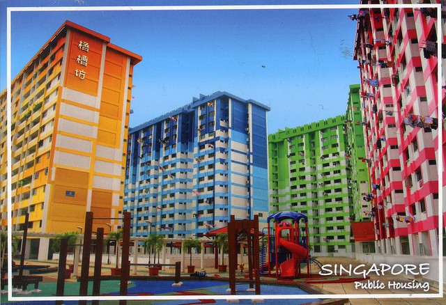
Singapore public housing
I received this postcard earlier this year through the South East Asia RR on the Postcrossing. There was a special group open for Year of the Sheep/Goat stamps and I just couldn't resist joining. I know the postcard isn't sheep-related, but that wasn't a requirement and I really don't mind (although I did feel bad when sending out my cards as I only had a few sheep postcards available; I do realise many people prefer the postcard to match). This card had actually been in my favourites for a while, so I was really pleased to receive it.
I wonder if all public housing in Singapore is this colourful...? ...and whether these blocks of flats are a little nicer than some council block of flats over here... :P Having said that, though, I do wish it was easier to get a council flat here - it's pretty much impossible unless you're in a priority group with special needs. :(
I wonder if all public housing in Singapore is this colourful...? ...and whether these blocks of flats are a little nicer than some council block of flats over here... :P Having said that, though, I do wish it was easier to get a council flat here - it's pretty much impossible unless you're in a priority group with special needs. :(
Labels:
2015,
cancellations,
RR,
singapore,
year of the horse,
year of the sheep
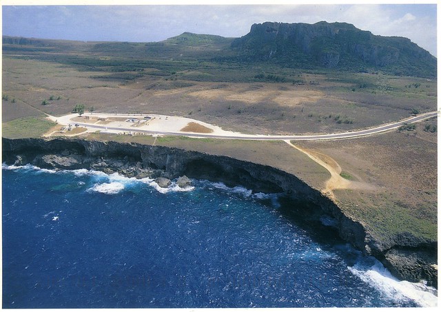
Banzai Cliff and Suicide Cliff, Saipan, Northern Mariana Islands
I only used to have one postcard from Northern Mariana Islands in my collection so I was really happy when I managed to squeeze into this group in the 'vacation RR' on the Postcrossing forum
...so yeah, I was really happy to receive this postcard but I do think the choice of image is a little morbid. This is an aerial view showing both Banzai Cliff on the coastline and Suicide Cliff on the interior of Saipan. At these sites hundreds of civilians and soldiers committed suicide by jumping over the cliffs. Why would you want to put that on a postcard??
The Northern Mariana Islands, officially the Commonwealth of the Northern Mariana Islands, is one of the five inhabited U.S. territories (the other four are Guam, Puerto Rico, the U.S. Virgin Islands, and American Samoa). It is one of two territories with "Commonwealth" status; the other is Puerto Rico. It consists of fifteen islands in the western Pacific Ocean, about three-quarters of the way from Hawaii to the Philippines. The United States Census Bureau reports the total land area of all islands as 475.26 km2. As of the 2010 census, the Northern Mariana Islands had a population of 53,883, of whom over 90% live on the island of Saipan. Of the 14 other islands, only two – Tinian and Rota – are permanently inhabited.
The Commonwealth's center of government is in the village of Capitol Hill on Saipan. As the island is governed as a single municipality, most publications name Saipan as the Commonwealth's capital.
Pre-Hispanic City and National Park of Palenque, Mexico
This card travelled for almost a year to me I think. So long that after a few months the sender, Brigitte, thought it had gone missing and sent a replacement. Well, it arrived right at the end of 2014 and was quite a surprise in my mailbox! This seems to happen quite a lot with mail from Mexico, though - a few swap cards have never arrived and a couple took months. I wonder what's up there...??
The archaeological site of Palenque in the state of Chiapas is one of the most outstanding Classic period sites of the Maya area, known for its exceptional and well conserved architectural and sculptural remains. The elegance and craftsmanship of the construction, as well as the lightness of the sculpted reliefs illustrating Mayan mythology, attest to the creative genius of this civilization.
The city was founded during the Late Preclassic, which corresponds to the beginning of the Christian era. Its first inhabitants probably migrated from other sites in the nearby region. They always shared the cultural features which define the Maya culture, as well as a level of development that allowed them to adapt to the natural environment. After several centuries, ca. 500 A.D., the city rose to be a powerful capital within a regional political unit. Without a buffer zone the total area of the archeological site is 1780 hectares, 09 areas and 49 square meters and 1,400 buildings have been recorded, of which only about 10% have been explored.
Palenque has been the object of interest of numerous travelers, explorers and researchers since the 18th century. It illustrates one of the most significant achievements of mankind in the American continent. The ancient city has a planned urban layout, with monumental edifices and some of the largest clearings found in all the Maya area. Numerous residential areas with habitation units, funerary, ritual and productive activity areas were placed around the administrative and civic ceremonial centre. The palencano style is unique for its high degree of refinement, lightness and harmony. It includes buildings with vaulted roofs upon which pierced crestings emphasized its height. Its architecture is also characterized by its interior sanctuaries and modeled stucco scenes found on its freezes, columns, walls, crests, as well as ogival vaults, vaulted halls connecting galleries and T-shaped windows, among other unique architectural features. The sophisticated architectural designs and the rich decoration reflect the history and ideology of the ruling class and incorporate the writing and calendaric systems. The architecture of the site is integrated in the landscape, creating a city of unique beauty.
Subscribe to:
Comments (Atom)






















 Maroon


