Thursday, 15 September 2011

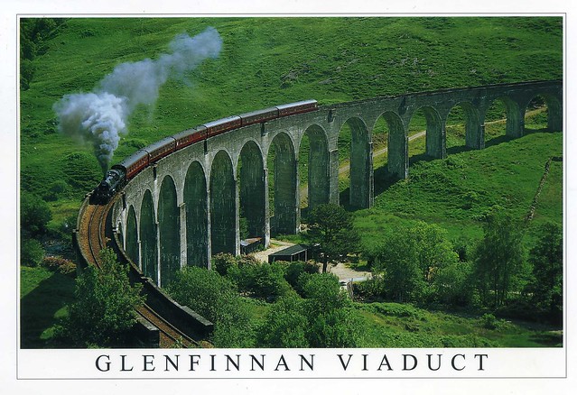
Glenfinnan Viaduct, Scotland

The last month and a half have been really hectic and so much has happened (not all very good, either.. :/) so I'm behind with a lot of things and not just this blog. I thought I'd post one more card today just to try and get back to the habit of updating this blog and maybe do that a bit more often again.. This one is holiday-themed as well - it's from Matt's older sister Rachel, sent during her holiday to Scotland last month. She spent a few days in Edinburgh and a while in the Highlands as well, which I'm perhaps even more jealous of. I'd love to visit the Scottish Highlands one day, too, and I certainly wouldn't mind travelling on 'Hogwarts Express'!


Glenfinnan Viaduct is a railway viaduct on the West Highland Line in Glenfinnan, Lochaber, Highland, Scotland. It was built between 1897 and 1901. Located at the top of Loch Shiel in the West Highlands of Scotland, the viaduct overlooks the Glenfinnan Monument and the waters of Loch Shiel.

The West Highland Line connects Fort William and Mallaig, and was a crucial vein for the local fishing industry and the highlands economy in general, which suffered enormously after the Highland Clearances of the 1800s.

The line is used by passenger trains operated by ScotRail between Glasgow Queen Street and Mallaig, usually diesel multiple units. Additionally in the summer the heritage Jacobite steam train operates along the line. It is a popular tourist event in the area, and the viaduct is one of the major attractions of the line. It is also the 'Harry Potter Express' - as Rachel put it :) She actually saw it pass by one of the B&B's she was staying in!


One of the most common stamps I see on my mail... It looks like this one's not very new, though, as it doesn't have any of the more recent security features on it.

Barcelona, Spain

I've been back from Barcelona for a little over a week now. It was such an amazing week, I had so much fun and wish I could've stayed longer (although I couldn't really have afforded it, it was so expensive over there!). Barcelona is such a beautiful city, there's tons to see, lots of whimsical architecture, palm trees everywhere (I was getting rather obsessed about these for some reason :p), seaside, lots of sunshine and warm/hot weather.. It was pretty depressing to come back to the rain and cold of England. ..and to think that me and Matt probably won't be able to afford another holiday again in a few years... *sigh*


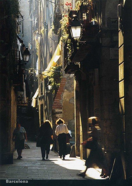
This is one of the many postcards I bought for myself. It says 'Ciutat Vella' on the back of the card - Ciutat Vella is the old part of the city, comprising of Barri Gòtic, El Raval, La Ribera, Sant Pere, Santa Caterina and Barceloneta. The picture on this card looks like it could be from Barri Gòtic, which was also probably my favourite area of the city we visited. I loved all the narrow streets and alleys, old historical buildings, all the little details, laundry hanging outside and other signs of "ordinary life", tiny shops and the atmosphere in general, even if it was packed with tourists so it's probably not all that "authentic" in the end. There were lots of amazing little ice cream and frozen yoghurt shops in Barri Gòtic, too, I know I'm going to miss them. My favourite was Gelaaati!, I liked it enough to go there twice and wouldn't have minded visiting it more.. :p I know the place isn't exactly Spanish but on this occasion I didn't mind too much. Otherwise it was really depressing to find all the Spanish restaurants to be so expensive and half the time me and Matt actually ended up eating in places like Burger King or KFC because we couldn't afford Spanish food all the time (we were lucky in that the breakfast in our hotel was so good and we didn't need to eat out so much thanks to that. They even had churros with hot chocolate! ..and manchego cheese which I loved). That was one of the only things I didn't like about the place and found really upsetting.

The hotel we stayed in wasn't very centrally located, but it was within walking distance from Plaça d'Espanya, and one evening we walked over to see the Magic Fountain of Montjuïc. It really was amazing, such a cool thing to see! Some of the music choices were a bit weird - music from 'Lord of the Rings' and 'Gladiator', for instance. They did play 'Barcelona' by Freddie Mercury and Montserrat Caballé, though, which made me happy.

Did I say I want to go back?!?

Thursday, 4 August 2011

Donegal, Ireland

I didn't mean to ignore this blog for such a long time. I've just been really busy in the past few weeks, and I expect it to be the same for a while so I probably won't be updating this blog again for some time. I thought I'd make a little post now in case anyone happened to be wondering what's going on. I'm getting married in less than two weeks so that's keeping me fairly busy. I'm starting to get quite nervous now... Hopefully everything will go well! Meanwhile, here's a pretty postcard of County Donegal in Ireland I received earlier this year.


Donegal is a county in Ireland. Donegal County Council is the local authority responsible for the county, and is part of the Border Region. County Donegal is located in the province of Ulster and is named after the town of Donegal. The population of the county is 160,927 according to the 2011 census.

In terms of size and area, Donegal is the largest county in Ulster and the fourth largest county in all of Ireland. Uniquely, County Donegal shares a border with only one other county in the Republic – County Leitrim. The majority of its land border is shared with three counties of Northern Ireland: County Londonderry, County Tyrone and County Fermanagh. This apparent economic 'isolation' has led to Donegal people maintaining a distinct cultural identity and has been used to market the county with the slogan Up here it's different. While Lifford is the County Town, the population of Letterkenny is much larger. Letterkenny and the nearby city of Derry form the main economic axis of the north-west of Ireland.

Physically, the county is by far the most rugged and mountainous in Ulster. The county consists chiefly of low mountains, with a deeply indented coastline forming natural loughs, of which both Lough Swilly and Lough Foyle are the most notable. The famous mountains (often known as 'the Hills of Donegal') consist of two major ranges, the Derryveagh Mountains in the north and the Bluestack Mountains in the south, with Mount Errigal at 749 metres (2,457 ft) the highest peak. The Slieve League cliffs are the sixth-highest sea cliffs in Europe, while Donegal's Malin Head is the most northerly point on the island of Ireland.

Saturday, 16 July 2011

Mongolia

My Finnish postcard pal Johanna certainly doesn't pick the most common destinations for her holidays. Last year she went to Greenland; this summer she visited Mongolia. ...and she was kind enough to send me a postcard from there. It arrived not long ago and made me super excited!


Johanna told me that this kind of view is very typical in Mongolia - yurts, cattle and lots of green. :) She even stayed in a yurt for a few nights, which must have been quite an experience.

Mongolia is a landlocked country in East and Central Asia. It is bordered by Russia to the north and the People's Republic of China to the south, east and west. Although Mongolia does not share a border with Kazakhstan, its western-most point is only 38 kilometres from Kazakhstan's eastern tip. Ulan Bator, the capital and largest city, is home to about 45% of the population. Mongolia's political system is a parliamentary republic.

The area of what is now Mongolia has been ruled by various nomadic empires, including the Xiongnu, the Xianbei, the Rouran, the Gökturks and others. The Mongol Empire was founded by Genghis Khan in 1206. After the collapse of the Yuan Dynasty, the Mongols returned to their earlier pattern of constant internal conflict and occasional raids on the Chinese borderlands. In the 16th and 17th centuries, Mongolia came under the influence of Tibetan Buddhism. At the end of the 17th century, most of Mongolia had been incorporated into the area ruled by the Qing Dynasty. During the collapse of the Qing Dynasty in 1911, Mongolia declared independence, but had to struggle until 1921 to firmly establish de facto independence from the Republic of China, and until 1945 to gain international recognition.

As a consequence, it came under strong Russian and Soviet influence; in 1924, the Mongolian People's Republic was declared, and Mongolian politics began to follow the same patterns as the Soviet politics of the time. After the breakdown of communist regimes in Eastern Europe in late 1989, Mongolia saw its own Democratic Revolution in early 1990, which led to a multi-party system, a new constitution in 1992, and transition to a market economy.

At 1,564,116 square kilometres, Mongolia is the 19th largest and the most sparsely populated independent country in the world, with a population of around 2.75 million people. It is also the world's second-largest landlocked country after Kazakhstan. The country contains very little arable land, as much of its area is covered by steppes, with mountains to the north and west and the Gobi Desert to the south. Approximately 30% of the population are nomadic or semi-nomadic. The predominant religion in Mongolia is Tibetan Buddhism, and the majority of the state's citizens are of the Mongol ethnicity, though Kazakhs, Tuvans, and other minorities also live in the country, especially in the west. About 20% of the population live on less than US$1.25 per day.


The stamp is from a set of 4 animal stamps issued in 2004.
Jerusalem, Israel

I know I've already posted a very similar card of Jerusalem before, but I couldn't resist posting about this one as well. I really like this view and the full moon on the left is such a cool addition, making the atmosphere here somewhat mysterious.


In the background you can see the Old City wall with Mount of Olives, a mountain ridge in East Jerusalem with three peaks running from north to south. The highest, at-Tur, rises to 818 meters. It is named for the olive groves that once covered its slopes. The Mount of Olives is associated predominantly with Jewish and Christian traditions but also contains several sites important in Islam. The mount has been used as a Jewish cemetery for over 3,000 years and holds approximately 150,000 graves.


Such a beautiful stamp! It's from a set of 3 stamps issued earlier this year under the theme 'Visit Israel'.

Map of Taiwan

Let's stay in Asia for a moment.. This card from Taiwan is one of the coolest map cards I've ever received - I love the cute illustrations and the huge number of tiny little details.


You can see all the major cities of Taiwan here, as well as all famous spots and landmarks. The Black Bear, DiDi, is in reality a native animal in Taiwan, "Formosan Black Bear". 'DiDi' means younger brother in Chinese, which is the official language of Taiwan.

Beijing, China

I love postcards showing everyday life in different countries, which is why I like this card so much. That, and the people here look so happy, it makes me smile as well. :)


The picture here is from a 'hutong' in Beijing, China. Hutongs are a type of narrow streets or alleys, most commonly associated with Beijing, China. In Beijing, hutongs are alleys formed by lines of siheyuan, traditional courtyard residences. Many neighbourhoods were formed by joining one siheyuan to another to form a hutong, and then joining one hutong to another. The word hutong is also used to refer to such neighbourhoods.

Since the mid-20th century, the number of Beijing hutongs has dropped dramatically as they are demolished to make way for new roads and buildings. More recently, some hutongs have been designated as protected areas in an attempt to preserve this aspect of Chinese cultural history.


The stamp is a New Year's stamp from 2009.

S.68, Russia

A very cool locomotive card I received from a swap with Andrey in Russia. We've exchanged a bunch of postcards now and I really like everything he's sent me so far.


This is a bit of a strange postcard - you couldn't really send it written and stamped because there's so much writing on the back of the card. I've seen cards like that from Russia before, I wonder if they exist in other countries as well? Anyway, at least there's some helpful info about the picture on the back:

One of the best passenger locomotives built in Russia before the revolution. Designed by B.S. Malakhovskii, chief engineer of Sormovo (hence the class name S).
Probably built by Nevskii Works in Petrograd in 1917. During 1960-1970s it was used as a stationary boiler in Moscow at an industrial enterprise. Restored at the October railway's Khovrino locomotive depot in 1983.
The single survivor of this class.

Point Bonita Lighthouse, CA, USA

I've recently joined two other swap sites in addition to Postcrossing: sendsomething and Swap-bot. I think I'll mostly stick to Postcrossing in the future, though, because these sites are a bit confusing (Swap-bot in particular) and I haven't been overly impressed with some of the cards I've received. There have been exceptions, though, my favourite being this gorgeous lighthouse postcard I received via sendsomething last month.


Point Bonita Lighthouse is located at Point Bonita at the San Francisco Bay entrance in the Marin Headlands near Sausalito, California. Point Bonita was the last manned lighthouse on the California coast.

The original Point Bonita Lighthouse, a 17 m brick tower, was located too high. Unlike the East Coast of the United States, the West Coast has dense high fog, which leaves lower elevations clear. The original light was 93 m above sea level so the second order Fresnel lens was often cloaked in fog and could not be seen from the sea. In 1877, the lighthouse was moved to its current location at 38 m above sea level. The United States Coast Guard currently maintains the light and fog signal. It is accessible to the public during limited hours (12:30 PM–3:30 PM) on Saturdays, Sundays, and Mondays. Up until 1940 the lighthouse could be reached without a bridge, but erosion caused a trail leading to the lighthouse to crumble into the sea. A wooden walkway was installed, but when that became treacherous the suspension bridge was built in 1954. The bridge was intended to mirror the design of the nearby Golden Gate Bridge.

As of January 6, 2010, the suspension bridge to the light house has been closed to public access. According to the Federal Highway Administration, the bridge, which is 56 years, has started to rust. It underwent repairs in 1979 and again in 1991, but the metal components are not able to stand up to the sea spray. The new span is set to open in March 2012. The new bridge construction is expected to cost between $850,000 and $1.3 million. The bridge will be made from tropical hardwood and steel suspension cables and attachments.


This card came with some really cool stamps. The two big stamps at the top are from a set of 5 stamps issued in 1999, depicting Arctic Animals, the ones here being tghe Polar Bear and Gray Wolf. The smaller stamp underneath is from a set of 2 (?) stamps issued in 1995, showing Fruits.

Sunday, 10 July 2011

Wildlife, Tristan da Cunha

Blogger has been playing up quite a bit today and I'm getting really fed up with it. :S Therefore, only one more card for today. I wrote earlier that I wanted to post more about Tristan da Cunha as I received a bunch of postscards from there. Well, here is another one, and a really lovely one at that, too.


Such beautiful animals! I would have no idea of their names but there's a helpful explanation on the back of the card:

Rockhopper Penguin, Sub-Antarctic Fur Seal (Protected at Gough & Inaccessible Islands), Wilkins'Bunting (Endemic to Nightingale Island, Endangered), Brown Noddy.

The penguin reminds me of one of the penguins in the film 'Happy Feet'. :D I really like that film, too, and what makes it more special to me is that I saw it for the first time in Edinburgh a few years ago with a dear friend. Memories...


Such lovely stamps! They are from a set of 12 stamps issued in 2010 under the theme 'Nature conservation'. Mmmm, and the special cancellation is very cool as well. :) I'm still surprised these cards didn't travel for ages to reach me.

Lake Baikal, Russia

I received this breathtaking view of Lake Baikal earlier this year. Doesn't it look amazing?!


Lake Baikal is the world's oldest and deepest lake at 30 million years old and with an average depth of 744.4 metres.

Located in the south of the Russian region of Siberia, between Irkutsk Oblast to the northwest and the Buryat Republic to the southeast, it is the most voluminous freshwater lake in the world, containing roughly 20% of the world's unfrozen surface fresh water.

At 1,642 metres, Lake Baikal is the deepest and among the clearest of all lakes in the world. Similarly to Lake Tanganyika, Lake Baikal was formed as an ancient rift valley, having the typical long crescent shape with a surface area of 31,722 km2, less than that of Lake Superior or Lake Victoria. Baikal is home to more than 1,700 species of plants and animals, two thirds of which can be found nowhere else in the world and was declared a UNESCO World Heritage Site in 1996. It is also home to Buryat tribes who reside on the eastern side of Lake Baikal, rearing goats, camels, cattle and sheep, where the regional temperatures vary from a minimum of −19 °C in winter to maximum of 14 °C in summer.


The big stamp on the left was issued in 2010 under the theme 'Military aviation school'. The stamp in the middle is from a set of 11 definitives issued in 1998 and stamp next to it on the right is from a set of 2 definitives issued in 2010, with the theme 'Coat of arms'. The stamp underneath is a definitive from 2008 in a set of 15 stamps depicting animals, this one here being the Hare.

Istanbul, Turkey

A beautiful card I received from 'Choose a Country RR', one of my favourite RRs on the postcrossing forum. I had had this card in my favourites for a while, I'm so happy to finally have a copy myself!


This card was mailed from Ukraine but it shows a view of Istanbul, Turkey. Istanbul is the largest city of Turkey. According to the address-based birth recording system of the Turkish Statistical Institute, the metropolitan municipality (province) of the city had a population of 13.26 million as of 2010, which is 17.98% of Turkey's population. The last census data from 2000 puts its proper population at 8.8 million. Istanbul is a megacity, as well as the cultural, economic, and financial centre of Turkey. It is located on the Bosphorus Strait and encompasses the natural harbour known as the Golden Horn, in the northwest of the country. It extends both on the European (Thrace) and on the Asian (Anatolia) sides of the Bosphorus, and is thereby the only metropolis in the world that is situated on two continents. Istanbul is a designated alpha world city.

During its long history, Istanbul has served as the capital of the Roman Empire (330–395), the Eastern Roman (Byzantine) Empire (395–1204 and 1261–1453), the Latin Empire (1204–1261), and the Ottoman Empire (1453–1922). When the Republic of Turkey was proclaimed on 29 October 1923, Ankara, which had previously served as the headquarters of the Turkish national movement during the Turkish War of Independence, was chosen as the new Turkish State's capital. Istanbul was chosen as a joint European Capital of Culture for 2010 and the European Capital of Sports for 2012. Istanbul is currently bidding to host the 2020 Summer Olympics. The historic areas of the city were added to the UNESCO World Heritage List in 1985.


As I said, this card was mailed from Ukraine. ...with the most amazing stamps! The one on the right is from a set of 6 lighthouse stamps issued in 2010, this one showing the Illichivskyi lighthouse. The train stamp is from a set of 4 stamps from 2010, depicting locomotives. The stamp underneath was issued in 2004 to commemorate the 250 Years of Yelysavethrad. Finally, the small stamp at the bottom is from a set of 4 stamps issued in 2008, depicting Handicrafts.