Saturday, 31 March 2012

Samoa

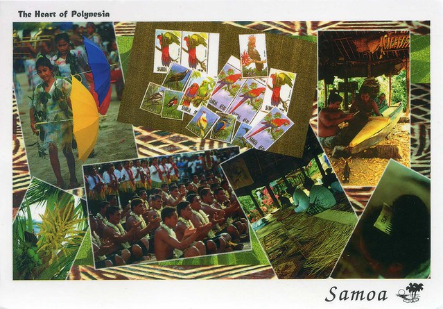
In the past few months I've been lucky enough to get some new countries in my postcard collection. This particular treat from Samoa arrived last December and I was super excited to find it in my mailbox (or rather, on the floor next to the slot in our front door :p)! :)


Samoa, officially the Independent State of Samoa, formerly known as Western Samoa, is a country encompassing the western part of the Samoan Islands in the South Pacific Ocean. It became independent from New Zealand in 1962. The two main islands of Samoa are Upolu and one of the biggest islands in Polynesia, Savai'i. The capital city, Apia, and Faleolo International Airport are situated on the island of Upolu.

Samoa was admitted to the United Nations on 15 December 1976. The entire island group, inclusive of American Samoa, was called Navigators Islands by European explorers before the 20th century because of the Samoans' seafaring skills.

Samoa is located south of the equator, about halfway between Hawai‘i and New Zealand in the Polynesian region of the Pacific Ocean. The total land area is 2,934 km² (slightly smaller than the U.S. state of Rhode Island), consisting of the two large islands of Upolu and Savai'i which account for 99% of the total land area, and eight small islets. The land area is about the size of the two Hawaii islands Oahu and Maui combined. The climate is equatorial/monsoonal, with an average annual temperature of 26.5°C, and a rainy season from November to April.

Samoa has a population of 182,265 of which 92.6% are Samoans, 7% Euronesians (people of mixed, European and Polynesian ancestors) and 0.4% are Europeans, per the CIA World Factbook. About three-quarters of the population live on the main island of Upolu. Only the Māori of New Zealand outnumber Samoans among Polynesian groups.

Lord Howe Island, Australia

Moving on to Australia... and this is a postcard I did not receive from Heather :D This one is from my postcard pal Sharon. I actually received a card from her a few days ago after a fairly long break. Apparently my last postcard to her got lost, or at least she never received it :( I hate it when that happens!


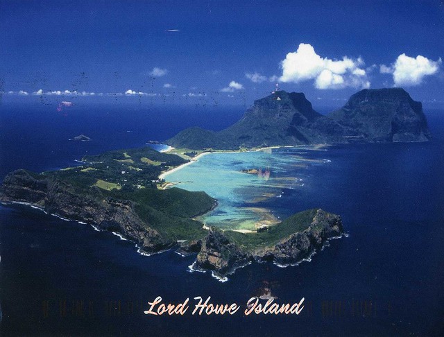
Lord Howe Island is an irregularly crescent-shaped volcanic remnant in the Tasman Sea between Australia and New Zealand, 600 kilometres directly east of mainland Port Macquarie, and about 900 kilometres from Norfolk Island. The island is about 10 km long and between 2.0 km and 0.3 km wide with an area of 14.55 km2, "of which only 398 hectares is in the lowland settled area". Along the west coast there is a sandy semi-enclosed sheltered coral reef lagoon. Most of the population lives in the north, while the south is dominated by forested hills rising to the highest point on the island, Mount Gower (875 m). The Lord Howe Island Group of islands comprises 28 islands, islets and rocks. Apart from Lord Howe Island itself the most notable of these is the volcanic and uninhabited Ball's Pyramid about 23 km to the south-east. To the north there is the Admiralty Group, a cluster of seven small uninhabited islands.

The first reported sighting of Lord Howe Island was on 17 February 1788 when Lieutenant Henry Lidgbird Ball, commander of the Armed Tender HMS Supply was on its way from Botany Bay to found a penal settlement on Norfolk Island. On the return journey Ball sent a party ashore on Lord Howe Island to claim it as a British possession. It subsequently became a provisioning port for the whaling industry, and was permanently settled in June 1834. When whaling declined, the worldwide export of the endemic kentia palms began in the 1880s, which remains a key component of the Island's economy. The other continuing industry, tourism, began after World War II.

The Lord Howe Island Group is recorded by UNESCO as a World Heritage Site of global natural significance. Most of the island is virtually untouched forest with many of the plants and animals found nowhere else in the world. Other natural attractions include the diversity of its landscapes, the variety of upper mantle and oceanic basalts, the world's southernmost barrier coral reef, nesting seabirds, and its rich historical and cultural heritage. The Lord Howe Island Act of 1981 established a "Permanent Park Preserve" (covering approximately 70 per cent of the island). The surrounding waters are a protected region designated the Lord Howe Island Marine Park.

The TranzAlpine, New Zealand

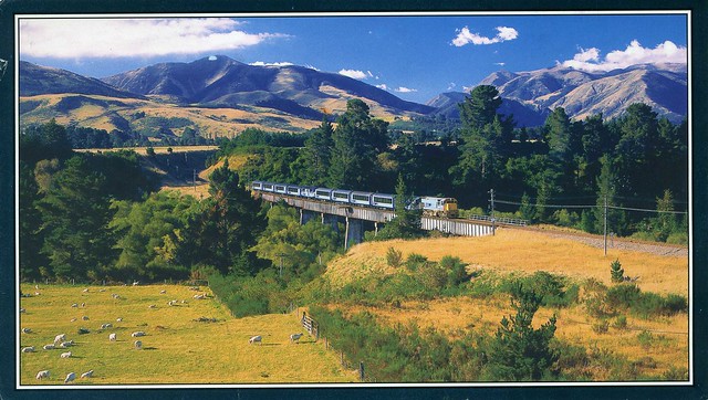
Another train postcard, this time from New Zealand, and another beauty from the 'Choose a Country' RR. This is SUCH a beautiful postcard - the view is amazing, and it's such a big card as well! ...and I love it how Annie always decorates her postcards. :)


This postcard shows the Kowai Bridge near Springfield in New Zealand. The popular TranzAlpine scenic train travels between Christchurch and Greymouth, on the West Coast. Here it is passing through typical sheep country, the type of scenery that New Zealand is famous for. There are mountains and much variety on the route, though. ...definitely sounds (and looks!) a lot nicer than the journey from Wolverhampton to Birmingham. :P

'Lättähattu' train, Finland

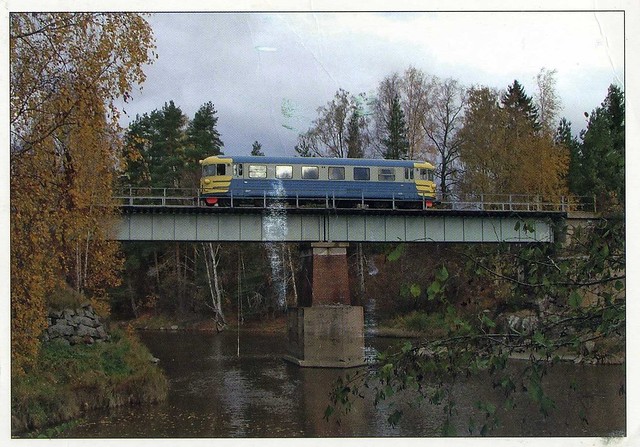
The Finnish Post issued a set of gorgeous train stamps earlier this year. I've already managed to get them all in my collection. This blue train is possibly one of my favourites, and I was really happy to receive it on a matching postcard.


The Dm6 and Dm7 were diesel multiple units built by Valmet in the 1950s and 1960s for VR (the state-owned railway company in Finland). They are known by their nickname lättähattu (Finnish for "flat hat", the first widespread youth culture movement in Finland).

At the beginning of the 1950s it became clear that VR needed multiple units to compete with buses in short-distance traffic. In 1952, seven Dm6:s were ordered from Valmet, and eight more the next year. After testing the Dm6:s and having noted that the new DMU:s worked well in Finnish conditions, VR ordered more units. In total, 197 Dm7 class multiple units were built with some modifications (a larger wheel size, for instance).

Three Dm7:s (numbers 4145–4147) were transformed into goods transport vehicles. They were withdrawn in 1981. All Dm6:s have been withdrawn from service. 20 Dm7:s are preserved by Finnish museum railway associations. No 4020 is at the Finnish Railway Museum.

Kraków, Poland

Earlier this week it was really warm and sunny here in England - above +20 C and you could go out in a t-shirt! It was lovely, I wish these sunny days weren't over yet. Something else earlier this week made me a LOT less happy.. the Royal Mail announced their annual price increases, and it's the biggest increase in 37 years, about 30% in average but some prices are going up even more (like parcels and packets). Needless to say I'm NOT happy. I'm going to have to cut back on the number of postcards I send. I still want to keep sending postcards to my postcard pals, friends and regular swappers, but I'll have to cut back on the number of officials I send, and limit my forum activities. I can sort of see why they need to increase the prices if they are making losses, but increases on this kind of scale just seem totally ridiculous and over the top, surely it's going to mean that people will send even less mail than before?! Seems to me like they're just trying to fatten up the Royal Mail for privatisation (and if/when that happens, I suspect even bigger price increases and worse service :(). Grrrrr!!

Anyway. I thought I'd post some nice cards here to cheer myself up a bit. This first beauty had been in my favourites for a while and then earlier this year I received it through one of my favourite RR's (Choose a Country RR). :)


I've already written about Kraków here so I'm not going to repeat myself. I wanted to post about this card anyway, though, because I simply adore it, the atmosphere in it is so beautiful. I love the tones here, it looks like such a surreal scene!

Saturday, 24 March 2012

Hato Caves, Curaçao

Today's last card is another treat I received from my penpal Lauren from her Caribbean cruise earlier this year. She really seems to have visited the most amazing places!


Hato Caves are show caves and a popular tourist attraction on the Caribbean island of Curaçao. The caves are north of the town of Willemstad on the Roosevelt Weg. The first known inhabitants of the caves were the Amerindian Arawaks, about 1,500 years ago. They left behind many petroglyphs (cave drawings). In the days of slavery, runaway slaves used the caves as hiding places.

Curaçao is an island in the southern Caribbean Sea, off the Venezuelan coast. The Country of Curaçao, which includes the main island plus the small, uninhabited island of Klein Curaçao ("Little Curaçao"), is a constituent country of the Kingdom of the Netherlands. Its capital is Willemstad.

Curaçao is the largest and most populous of the three ABC islands (for Aruba, Bonaire, and Curaçao) of the Lesser Antilles, specifically the Leeward Antilles. It has a land area of 444 square kilometres. As of 1 January 2009, it had a population of 141,766.

Curaçao has a semiarid climate with a dry season from January to September and a wet season from October to December. The temperatures are relatively constant with small differences throughout the year. The trade winds bring cooling during the day and the same trade winds bring warming during the night. The coldest month is January with an average temperature of 26.5 °C and the warmest month is September with an average temperature of 28.9 °C. The year's average maximum temperature is 31.2 °C. The year's average minimum temperature is 25.3 °C. Curaçao lies outside the hurricane belt, but is still occasionally affected by hurricanes, as for example Omar in 2008.

Because of its history, the island's population comes from many ethnic backgrounds. There is an Afro-Caribbean majority of African descent, and also sizeable minorities of Dutch, Latin American, French, South Asian, East Asian, Portuguese and Levantine people. In the early 19th century, many Portuguese and Lebanese migrated to Curaçao attracted by the financial possibilities of the island. East and South Asian migrants arrived during the economic boom of the early 20th century. There are also many recent immigrants from neighbouring countries, most notably the Dominican Republic, Haiti, the Anglophone Caribbean and Colombia. In recent years the influx of Dutch pensioners has increased significantly, dubbed locally as pensionados.

Adjuntas, Puerto Rico

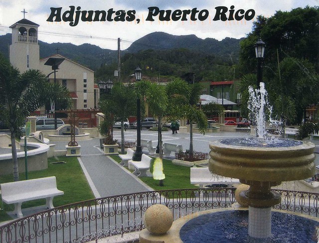
I don't have too many postcards from Puerto Rico so when Giselle was offering postcards for a swap on the forum, I just couldn't say 'no'. She sent me this great view of her home town.


Adjuntas is a small mountainside municipality in Puerto Rico located central midwest of the island on the Central Mountain range (La Cordillera Central). Adjuntas is spread over 16 wards and Adjuntas Pueblo (the downtown area and the administrative center of the city). Adjuntas is about two hours by car westward from the capital, San Juan. It is the principal city of the Adjuntas Micropolitan Statistical Area.

Adjuntas is nicknamed "the Switzerland of Puerto Rico", because of its relatively chilly weather. Many Puerto Rican mountain towns have colder weather than the rest of the island; Adjuntas is no exception: the average yearly weather is 72 degrees Fahrenheit. The cool weather attracts a good number of island tourists during the summer months. The town has a small hotel named Monte Rio and a good size parador, or country inn, called Villa Sotomayor. It also has the distinction of being the postal area with the lowest numerical ZIP code in the United States Postal Service (00601).

Singapore

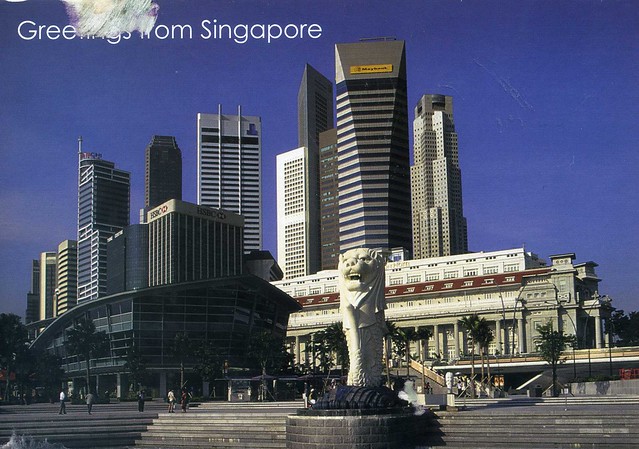
A lovely view from Singapore I received through the 'Vacation RR' on the Postcrossing forum. Mmmm, I wouldn't mind going on holiday somewhere a bit further away than London, either!


This is a view of the Merlion, Fullerton Hotel and skyscrapers in the business centre, a popular tourist attraction in Singapore.

Singapore is a Southeast Asian city-state off the southern tip of the Malay Peninsula, 137 kilometres north of the equator. An island country made up of 63 islands, it is separated from Malaysia by the Straits of Johor to its north and from Indonesia's Riau Islands by the Singapore Strait to its south. Singapore is highly urbanised but almost half of the country is covered by greenery. More land is being created for development through land reclamation.

Singapore had been a part of various local empires since it was first inhabited in the second century AD. Modern Singapore was founded as a trading post of the East India Company by Sir Stamford Raffles in 1819 with permission from the Sultanate of Johor. The British obtained full sovereignty over the island in 1824 and Singapore became one of the British Straits Settlements in 1826. Singapore was occupied by the Japanese in World War II and reverted to British rule after the war. It became internally self-governing in 1959. Singapore united with other former British territories to form Malaysia in 1963 and became a fully independent state two years later after separation from Malaysia. Since then it has had a massive increase in wealth, and is one of the Four Asian Tigers. The economy depends heavily on the industry and service sectors. Singapore is a world leader in several areas: It is the world's fourth-leading financial centre, the world's second-biggest casino gambling market, and the world's third-largest oil refining centre. The port of Singapore is one of the five busiest ports in the world, most notable for being the busiest transshipment port in the world. The country is home to more US dollar millionaire households per capita than any other country. The World Bank notes Singapore as the easiest place in the world to do business. The country has the world's third highest GDP PPP per capita of US$59,936, making Singapore one of the world's wealthiest countries.

Singapore is a parliamentary republic with a Westminster system of unicameral parliamentary government. The People's Action Party (PAP) has won every election since the British grant of internal self-government in 1959. The legal system of Singapore has its foundations in the English common law system, but modifications have been made to it over the years, such as the removal of trial by jury. The PAP's popular image is that of a strong, experienced and highly qualified government, backed by a skilled Civil Service and an education system with an emphasis on achievement and meritocracy; but it is perceived by some voters, opposition critics and international observers as being authoritarian and too restrictive on individual freedom.

Some 5 million people live in Singapore, of whom 2.91 million were born locally. Most are of Chinese, Malay or Indian descent. There are four official languages: English, Chinese, Malay and Tamil.

Railway Station, Vladivostok, Russia

I'll be going to London at the beginning of April for a couple of days. My sister is coming there for a few days and we both wanted to meet up. I'm actually taking a train to London this time; I found out it's not *that* expensive if you book in advance and avoid peak times. It's going to be so good to see my sister again!

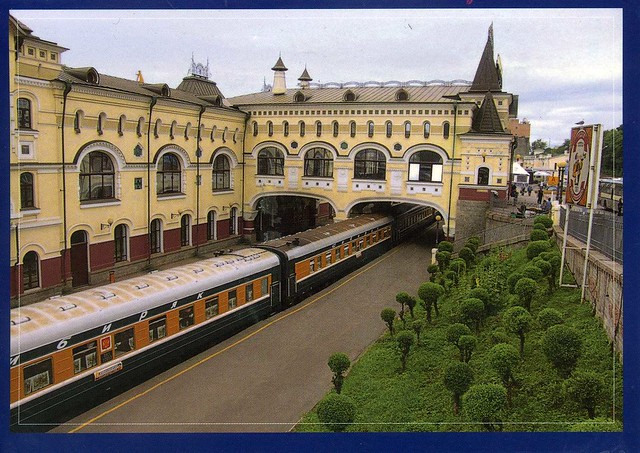
London Euston railway station is far less pretty than this one in Vladivostok.. :p


The railway terminal station in Vladivostok is an architectural monument, built 100 years ago. It's also the last stop for the Great Trans-Siberian Railway. The Trans-Siberian Railway is a network of railways connecting Moscow with the Russian Far East and the Sea of Japan. It is the longest railway in the world. There are branch lines to China through Mongolia and Manchuria, with service continuing to North Korea. What an experience it must be to travel the whole route!

Saturday, 17 March 2012

Monaco

Sheila of the awesome A Postcard a Day visited Monaco last year and offered to send postcards from there to those interested. I was SO excited to receive her postcard - it's my first written and stamped postcard from Monaco! :) Thank you sooo much, Sheila!


Monaco, officially the Principality of Monaco, is a sovereign city state, located on the French Riviera in Western Europe. Bordered by France on three sides, with one side bordering the Mediterranean Sea, its center is about 16 km from Italy, and is only 15 km north east of Nice, France. It has an area of 1.98 km2, and a population of 35,986, making Monaco the second smallest and the most densely populated country in the world. Monaco has a land border of only 4.4 km, a coastline of 4.1 km, and a width that varies between 1.7 km and 349 metres. The highest point in the country is a narrow pathway named Chemin des Révoires on the slopes of Mont Agel, in the Les Révoires district, which is 161 metres above sea level. Monaco's most populated Quartier is Monte Carlo, and the most populated Ward is Larvotto/Bas Moulins. After a recent expansion of Port Hercules, Monaco's total area is 2.05 km2, with new plans to extend the district of Fontvieille, with land reclaimed from the Mediterranean Sea.

Monaco is a principality governed under a form of constitutional monarchy, with Prince Albert II as head of state. However, even though Prince Albert II is a constitutional monarch, he still has immense political power. The House of Grimaldi have ruled Monaco, with brief interruptions, since 1297. The official language is French, but Monégasque, Italian, and English are widely spoken and understood (see here). The state's sovereignty was officially recognized by the Franco-Monegasque Treaty of 1861, with Monaco finally becoming a full UN voting member in 2002, after much political debate. Despite Monaco's independence and separate foreign policy, its defence is the responsibility of France. However, Monaco does maintain two small military units, totaling 255 officers and men, the Corps des Sapeurs-Pompiers de Monaco, and the Compagnie des Carabiniers du Prince.

Economic development was spurred in the late 19th century with a railroad line to France, and the opening of the first casino, Monte Carlo Casino. Since then, the principality's mild climate, splendid scenery, and gambling facilities have made Monaco world-famous as a tourist and recreation center for the rich and famous. However, in more recent years Monaco has become a major banking center holding over 100 billion euros worth of funds, and has successfully sought to diversify its economy into the services and small, high-value-added, nonpolluting industries. The state has no income tax and low business taxes, and is well-known for being a tax haven. Monaco boasts the world's highest GDP nominal per capita at $172,676, and GDP PPP per capita at $186,175. Monaco also has the world's highest life expectancy at almost 90 years, and the lowest unemployment rate at 0%, with over 48,000 workers who commute from France and Italy each day. For the third year in a row, Monaco in 2011 had the world's most expensive real estate market, at $56,300 per square metre. According to the CIA World Factbook, Monaco has the world's lowest poverty rate, and the highest millionaires and billionaires per capita in the world.

Lviv, Ukraine

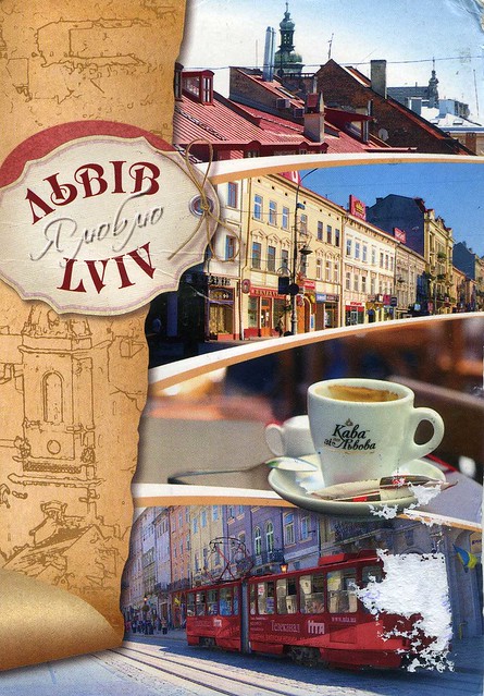
I know I've already written about Lviv here, but I just couldn't resist posting this card here as well. It had suffered quite a bit on its way to England, but I simply adore this card, there are so many lovely details in it! ...and I'm not usually all that fond of multiviews!


UA-105702


According to Vasylyna, who sent me this card (and added cute stickers and a pretty drawing on the back of the card), Lviv is the cultural capital of Europe, and also a city of coffee :) I don't actually like coffee at all, but I wouldn't mind sitting in a cafe in such a pretty city, maybe drinking a cup of tea instead? ...and then travel on that tram and admire the gorgeously colourful houses. Mmmmmmm...!

Läänemaa, Estonia

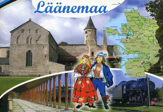
A lovely map postcard I received from Estonia last year. I love the cards in this series, showing different parts of Estonia.


Läänemaa (Lääne County) is one of 15 counties of Estonia. It is located in western Estonia and borders Baltic Sea to the north, Harju County to the north-east, Rapla County to the east, Pärnu County to the south, and the island counties of Saare and Hiiu to the west. 27,477 people live in Lääne County – constituting 2.0% of the total population in Estonia (as of January 2009).

On this card, on the top you can see the Episcopal castle in Haapsalu and on the bottom a railway station (also in Haapsalu? it doesn't say anywhere on the card), and the drawing in the middle is of national clothes of a girl and a boy of Lihula.