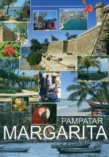
A lovely postcard I received from dear Daniela last year. This is one of those few cases where I don't mind a card being a multiview - I really like all the little details here (even if it would be nice to see bigger pictures of the colourful houses...). ...and it's another seaside view! :D
Pampatar is a city on Isla Margarita, Nueva Esparta State, Venezuela. It is located in the Maneiro Municipality.
Pampatar lies 10 km northeast of Porlamar. It's a coastal town, founded in 1552. Its strategic importance becomes clear when visiting the Castillo de San Carlos de Borromeo on the waterfront in the center of town. Constructed entirely of coral, the fort, built by the Spanish in 1662 after the original was destroyed by the Dutch. In the center of town is the Iglesia Santísimo Cristo or Iglesia del Cristo del Buen viaje, which features a bell tower with an outside staircase — an architectural oddity found on several churches on Isla Margarita. Nowadays this town is very famous for its malls (Sambil or Rattan Plaza) and its commercial activity 24 hours a day.
Saturday, 26 May 2012
Goli otok, Croatia
More seaside views... This time from Croatia, sent my the lovely Nives last year. Yeah, I'm really behind with this blog - I have TONS of postcards I want to post about here!
Goli otok is an island off the northern Adriatic coast, located between Rab's northeastern shore and the mainland, in what is today Croatia's Primorje-Gorski Kotar county. The island is barren and uninhabited. Its northern shore is almost completely bare, while the southern one has small amounts of vegetation as well as a number of coves.
Despite having long been an occasional grazing ground for local shepherds' flocks, the barren island was apparently never permanently settled other than during the 20th century. Throughout World War I, Austria-Hungary sent Russian prisoners of war from Eastern Front to Goli otok.
In 1949, the entire island was officially made into a high-security, top secret prison and labor camp run by the authorities of FPR Yugoslavia, together with the nearby Sveti Grgur island, which held a similar camp for female prisoners. Until 1956, throughout the Informbiro period, it was used to incarcerate political prisoners. These included known and alleged Stalinists, but also other Communist Party members or even nonparty citizens accused of exhibiting sympathy or leanings towards the Soviet Union. Many anticommunist (Serbian, Croatian, Macedonian, Albanian and other nationalists etc.) were also incarcerated on Goli Otok. Non-political prisoners were also sent to the island to serve out simple criminal sentences and some of them were sentenced to death. Numbers of total prisoners and massacred victims are unknown but Vladimir Dedijer estimates 32,000 male prisoners in Goli otok only; other historians estimates 4,000 killed.
Goli otok is an island off the northern Adriatic coast, located between Rab's northeastern shore and the mainland, in what is today Croatia's Primorje-Gorski Kotar county. The island is barren and uninhabited. Its northern shore is almost completely bare, while the southern one has small amounts of vegetation as well as a number of coves.
Despite having long been an occasional grazing ground for local shepherds' flocks, the barren island was apparently never permanently settled other than during the 20th century. Throughout World War I, Austria-Hungary sent Russian prisoners of war from Eastern Front to Goli otok.
In 1949, the entire island was officially made into a high-security, top secret prison and labor camp run by the authorities of FPR Yugoslavia, together with the nearby Sveti Grgur island, which held a similar camp for female prisoners. Until 1956, throughout the Informbiro period, it was used to incarcerate political prisoners. These included known and alleged Stalinists, but also other Communist Party members or even nonparty citizens accused of exhibiting sympathy or leanings towards the Soviet Union. Many anticommunist (Serbian, Croatian, Macedonian, Albanian and other nationalists etc.) were also incarcerated on Goli Otok. Non-political prisoners were also sent to the island to serve out simple criminal sentences and some of them were sentenced to death. Numbers of total prisoners and massacred victims are unknown but Vladimir Dedijer estimates 32,000 male prisoners in Goli otok only; other historians estimates 4,000 killed.
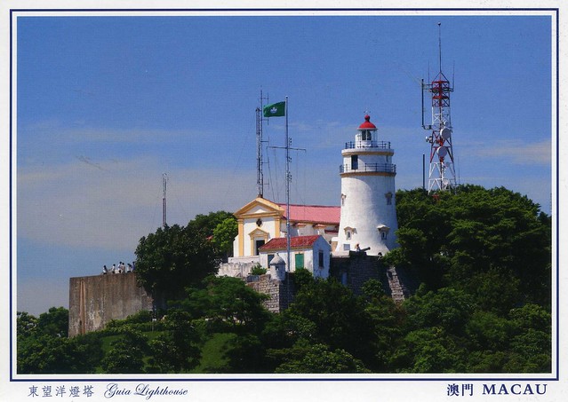
Guia Fortress, Macau
Another postcard from a friend.. My dear friend Miranda went back home to Hong Kong again recently and came back a couple of weeks ago. While she was away she also visited Macau, and brought me a gorgeous postcard pack of Macau. The cards are all amazing, I had a hard time picking just one to post about here. I chose this one as it's a slightly different view of Macau and I really like the colours here.
The Guia Fortress is a historical military fort, chapel, and lighthouse complex in the St. Lazarus Parish. The complex is a UNESCO World Heritage Site as part of the Historic Centre of Macau.
The fort and chapel were constructed between 1622 and 1638, after an unsuccessful attempt by the Netherlands to capture Macau from Portugal. The lighthouse was constructed between 1864 and 1865, the first western style lighthouse in east Asia or on the China coast. The lighthouse stands at 91 meters tall, and has a light visible for some 20 miles in clear weather conditions. The complex was built upon the highest point on Macau, Guia Hill, and named after the same location. Today, the site is a tourist destination.
The Guia Fortress is a historical military fort, chapel, and lighthouse complex in the St. Lazarus Parish. The complex is a UNESCO World Heritage Site as part of the Historic Centre of Macau.
The fort and chapel were constructed between 1622 and 1638, after an unsuccessful attempt by the Netherlands to capture Macau from Portugal. The lighthouse was constructed between 1864 and 1865, the first western style lighthouse in east Asia or on the China coast. The lighthouse stands at 91 meters tall, and has a light visible for some 20 miles in clear weather conditions. The complex was built upon the highest point on Macau, Guia Hill, and named after the same location. Today, the site is a tourist destination.
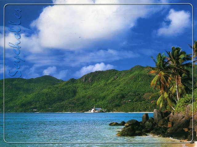
Seychelles
This week has been really sunny and warm, well over +20 C every day. It makes a nice change to the usual rain and cold, although the heat hasn't been much fun during Aikido lessons (there's no air conditioning at the sports hall in the university where I practice). Otherwise I can't complain much. :) ...although at times like this I wish I lived closer to the sea and not in the middle of England, about as far from the seaside as you can get in this country. I'd love to go on a beach!
I wouldn't mind a beach like this either ;) It looks like such a perfect place, a tropical paradise. This beach is located in Anse Royale, an administrative district of Seychelles located on the island of Mahé. My penpal Sperenza sent me this card last year and it's my first written and stamped postcard from Seychelles. :)
Wednesday, 23 May 2012
Bangladesh
Just one more card for today.. I'll need to leave in about half an hour - I'll be meeting up with Matt after he finishes work and then the plan is to go to the cinema to see 'Dark Shadows' (I'm a bit worried as most of the reviews I've read about it haven't been very good, but I really love most Tim Burton films so I do have to give it a try at least!). Anyway.. this card is such a treat: my first ever written and stamped postcard from Bangladesh! I'd tried to arrange a swap from there before but that didn't work out. ..then earlier this year another opportunity arose and I just couldn't resist ;)
I really, really like this card. The place it depicts looks so peaceful and tranquil, and the yellow field looks so pretty.
Bangladesh is a sovereign state located in South Asia. It is bordered by India and Burma and by the Bay of Bengal to the south. The capital (and largest city) is Dhaka, located in central Bangladesh. The official state language is Bengali. The name Bangladesh means "Country of Bengal" in the official Bengali language.
The borders of present-day Bangladesh were established with the partition of Bengal during the reign and demise of the British India. Its map was chartered by Sir Cyril Radcliffe during the creation of Pakistan and India in 1947, when the region became East Pakistan, part of the newly formed nation of Pakistan. Due to political exclusion and economic exploitation by the politically dominant West Pakistan, popular agitation grew against West Pakistan and led to the Bangladesh Liberation War in 1971, after the Bangladeshi Declaration of Independence on 26 March 1971. With the direct and indirect help of India, 9 months of war came to an end on 16 December 1971 by the surrender of the Pakistan Army at Ramna Race Course, after 13 days of direct action by the Indian Army.
Bangladesh is a parliamentary democracy, with an elected parliament called the Jatiyo Sangshad. It is the eighth-most populous country and among the most densely populated countries in the world. Just like in the rest of South Asia the poverty rate prevails, although the United Nations has acclaimed Bangladesh for achieving tremendous progress in human development. Geographically, the country straddles the fertile Ganges-Brahmaputra Delta and is subject to annual monsoon floods and cyclones.
The country is listed among the Next Eleven economies. It is a founding member of the South Asian Association for Regional Cooperation, BCIM, the D-8 and BIMSTEC, and a member of the Commonwealth of Nations, the Organisation of Islamic Cooperation and the Non-Aligned Movement. However, Bangladesh continues to face a number of major challenges, including widespread political and bureaucratic corruption, widespread poverty, and an increasing danger of hydrologic shocks brought on by ecological vulnerability to climate change.
I really, really like this card. The place it depicts looks so peaceful and tranquil, and the yellow field looks so pretty.
Bangladesh is a sovereign state located in South Asia. It is bordered by India and Burma and by the Bay of Bengal to the south. The capital (and largest city) is Dhaka, located in central Bangladesh. The official state language is Bengali. The name Bangladesh means "Country of Bengal" in the official Bengali language.
The borders of present-day Bangladesh were established with the partition of Bengal during the reign and demise of the British India. Its map was chartered by Sir Cyril Radcliffe during the creation of Pakistan and India in 1947, when the region became East Pakistan, part of the newly formed nation of Pakistan. Due to political exclusion and economic exploitation by the politically dominant West Pakistan, popular agitation grew against West Pakistan and led to the Bangladesh Liberation War in 1971, after the Bangladeshi Declaration of Independence on 26 March 1971. With the direct and indirect help of India, 9 months of war came to an end on 16 December 1971 by the surrender of the Pakistan Army at Ramna Race Course, after 13 days of direct action by the Indian Army.
Bangladesh is a parliamentary democracy, with an elected parliament called the Jatiyo Sangshad. It is the eighth-most populous country and among the most densely populated countries in the world. Just like in the rest of South Asia the poverty rate prevails, although the United Nations has acclaimed Bangladesh for achieving tremendous progress in human development. Geographically, the country straddles the fertile Ganges-Brahmaputra Delta and is subject to annual monsoon floods and cyclones.
The country is listed among the Next Eleven economies. It is a founding member of the South Asian Association for Regional Cooperation, BCIM, the D-8 and BIMSTEC, and a member of the Commonwealth of Nations, the Organisation of Islamic Cooperation and the Non-Aligned Movement. However, Bangladesh continues to face a number of major challenges, including widespread political and bureaucratic corruption, widespread poverty, and an increasing danger of hydrologic shocks brought on by ecological vulnerability to climate change.
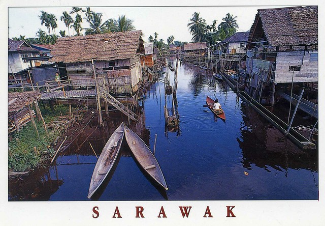
Sarawak, Malaysia
Ok, I got the idea from Ana - to have a specific thread on the Postcrossing forum to ask for swaps for postcards from my favourites. It's been so much fun (even if I was quite overwhelmed at first because SO many people offered to swap!) and I've received lots of beautiful postcards as a result. Why didn't I try that earlier?! :P Anyway, this is one of the cards I've received from that little 'project'; a lovely view from Malaysia. Thank you so much, Aileen!
On this card you can see a typical Melanau village at Kampung Tillian near Mukah. The Melanau, traditionally fishermen and sago growers, built their houses on or near rivers to allow easy access to the sea and effortless transport of sago logs.
Sarawak, then, is one of two Malaysian states on the island of Borneo. Known as Bumi Kenyalang ("Land of the Hornbills"), Sarawak is situated on the north-west of the island. It is the largest state in Malaysia followed by Sabah, the second largest state located to the north-east.
The administrative capital is Kuching, which has a population of 579,900. Major cities and towns include Miri (pop. 263,000), Sibu (pop. 254,000) and Bintulu (pop. 176,800). As of the last census (2010), the state population was 2,420,009. Sarawak has more than 40 sub-ethnic groups, each with its own distinct language, culture and lifestyle. Cities and larger towns are populated predominantly by Malays, Melanaus, Chinese, Indians and a smaller percentage of Ibans and Bidayuhs who have migrated from their home-villages for employment reasons. Generally, Sarawak has seven major ethnic groups namely Iban, Chinese, Malay, Bidayuh, Melanau, Orang Ulu and 'others'. Several more minor ethnics which do not belong to any of these seven major ethnic groups are Kedayan, Javanese, Bugis, Murut and Indian. Unlike Indonesia, the term Dayak is not officially used to address Sarawakian's native ethnicity.
Sarawak has an abundance of natural resources. LNG and petroleum have provided the mainstay of the Malaysia federal government's economy for decades while State of Sarawak only get a 5% royalty from it. Sarawak is also one of the world's largest exporters of tropical hardwood timber and is the major contributor to Malaysian exports.
On this card you can see a typical Melanau village at Kampung Tillian near Mukah. The Melanau, traditionally fishermen and sago growers, built their houses on or near rivers to allow easy access to the sea and effortless transport of sago logs.
Sarawak, then, is one of two Malaysian states on the island of Borneo. Known as Bumi Kenyalang ("Land of the Hornbills"), Sarawak is situated on the north-west of the island. It is the largest state in Malaysia followed by Sabah, the second largest state located to the north-east.
The administrative capital is Kuching, which has a population of 579,900. Major cities and towns include Miri (pop. 263,000), Sibu (pop. 254,000) and Bintulu (pop. 176,800). As of the last census (2010), the state population was 2,420,009. Sarawak has more than 40 sub-ethnic groups, each with its own distinct language, culture and lifestyle. Cities and larger towns are populated predominantly by Malays, Melanaus, Chinese, Indians and a smaller percentage of Ibans and Bidayuhs who have migrated from their home-villages for employment reasons. Generally, Sarawak has seven major ethnic groups namely Iban, Chinese, Malay, Bidayuh, Melanau, Orang Ulu and 'others'. Several more minor ethnics which do not belong to any of these seven major ethnic groups are Kedayan, Javanese, Bugis, Murut and Indian. Unlike Indonesia, the term Dayak is not officially used to address Sarawakian's native ethnicity.
Sarawak has an abundance of natural resources. LNG and petroleum have provided the mainstay of the Malaysia federal government's economy for decades while State of Sarawak only get a 5% royalty from it. Sarawak is also one of the world's largest exporters of tropical hardwood timber and is the major contributor to Malaysian exports.
Cantabria, Spain
A lovely map card I received from the wonderful 'Choose a Country' RR. (I've just hosted my own group in this RR as well, which has been fun as usual.) I just love these map cards with all the little details!
Cantabria is a Spanish historical region and autonomous community with Santander as its capital city. It is bordered on the east by the Basque Autonomous Community (province of Biscay), on the south by Castile and León (provinces of León, Palencia and Burgos), on the west by the Principality of Asturias, and on the north by the Cantabrian Sea (Bay of Biscay).
Cantabria belongs to Green Spain, the name given to the strip of land between the Bay of Biscay and the Cantabrian Mountains, so called because of its particularly lush vegetation, due to the wet and moderate oceanic climate. The climate is strongly influenced by Atlantic Ocean winds trapped by the mountains; the average precipitation is about 1,200 mm.
Cantabria is the richest region in the world for archaeological sites from the Upper Paleolithic period, although the first signs of human occupation date from Lower Paleolithic. The most significant site for cave paintings is that in the cave of Altamira, dating from about 16,000 to 9000 BC and declared, along with nine other Cantabrian caves, as World Heritage Sites by UNESCO.
The modern Province of Cantabria was constituted on 28 July 1778. The Organic Law of the Autonomy Statute of Cantabria was approved on 30 December 1981, giving the region its own institutions of self government.
Cantabria is a Spanish historical region and autonomous community with Santander as its capital city. It is bordered on the east by the Basque Autonomous Community (province of Biscay), on the south by Castile and León (provinces of León, Palencia and Burgos), on the west by the Principality of Asturias, and on the north by the Cantabrian Sea (Bay of Biscay).
Cantabria belongs to Green Spain, the name given to the strip of land between the Bay of Biscay and the Cantabrian Mountains, so called because of its particularly lush vegetation, due to the wet and moderate oceanic climate. The climate is strongly influenced by Atlantic Ocean winds trapped by the mountains; the average precipitation is about 1,200 mm.
Cantabria is the richest region in the world for archaeological sites from the Upper Paleolithic period, although the first signs of human occupation date from Lower Paleolithic. The most significant site for cave paintings is that in the cave of Altamira, dating from about 16,000 to 9000 BC and declared, along with nine other Cantabrian caves, as World Heritage Sites by UNESCO.
The modern Province of Cantabria was constituted on 28 July 1778. The Organic Law of the Autonomy Statute of Cantabria was approved on 30 December 1981, giving the region its own institutions of self government.
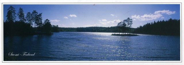
Finland
This blog turned two years last Thursday and I was going to write a special post about it, but then something happened and updating a postcard blog wasn't exactly one of my top priorities. I don't want to go into details here but I might be going to Finland at some point this summer. (Although mum did say that another option might be for her and dad to come over to England at some point, but nothing's quite sure at this point.)
Speaking of Finland, I've been receiving even more postcards from there than usual this month thanks to my dear friend Paula who deRRided to surprise me and asked for her cards in the Finnish 'May RR' to be sent to me instead as RAS cards. I'm still quite overwhelmed by her surprise, that was such a sweet thing to do! ...and the cards I've received have been amazing, so many lovely treats in my mailbox!
This is one of the cards I received from this RR. You can't really tell from the scan, but it's a huge panoramic card, SO pretty and really makes me miss Finland. My parents often spend their days off by a lake like this during summers and now that I live in England, I really love visiting the place again. I have no idea what lake the one on this card is as there's nothing about it anywhere on the card. They all look so similar (but beautiful!).
The stamp is so pretty as well! It shows the Bothnian Sea National Park in Finland. I'm so excited about the first day cancellation, too :)
Speaking of Finland, I've been receiving even more postcards from there than usual this month thanks to my dear friend Paula who deRRided to surprise me and asked for her cards in the Finnish 'May RR' to be sent to me instead as RAS cards. I'm still quite overwhelmed by her surprise, that was such a sweet thing to do! ...and the cards I've received have been amazing, so many lovely treats in my mailbox!
This is one of the cards I received from this RR. You can't really tell from the scan, but it's a huge panoramic card, SO pretty and really makes me miss Finland. My parents often spend their days off by a lake like this during summers and now that I live in England, I really love visiting the place again. I have no idea what lake the one on this card is as there's nothing about it anywhere on the card. They all look so similar (but beautiful!).
The stamp is so pretty as well! It shows the Bothnian Sea National Park in Finland. I'm so excited about the first day cancellation, too :)
Thursday, 10 May 2012
Drakensberg, South Africa
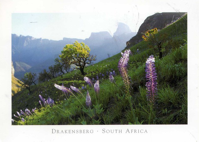
I only just realised that there aren't any postcards from South Africa in this blog. Ooops.. Maybe it's not so surprising, though, considering I only have a few postcards from there. ...which is why I was so excited earlier this year to find a swap offer, and I received this GORGEOUS postcard. It's such a treat!
The Drakensberg is the highest mountain range in Southern Africa, rising to 3,482 metres in height. In Zulu, it is referred to as uKhahlamba ("barrier of spears"). Its geological history lends it a distinctive character amongst the mountain ranges of the world. Geologically, the range resembles the Simien Mountains of Ethiopia. The Drakensberg mountain range is didived into three sections known as Northern, Central and Southern. This postcard is from the northern part and you can see the peak known as Monk's Cowl on the right hand side.
The Drakensberg Park has exceptional natural beauty in its soaring basaltic buttresses, incisive dramatic cutbacks, and golden sandstone ramparts. Rolling high altitude grasslands, the pristine steep-sided river valleys and rocky gorges also contribute to the beauty of the site. The site’s diversity of habitats protects a high level of endemic and globally threatened species, especially birds and plants. This spectacular natural site also contains many caves and rock-shelters with the largest and most concentrated group of paintings in Africa south of the Sahara, made by the San people over a period of 4,000 years. The rock paintings are outstanding in quality and diversity of subject and in their depiction of animals and human beings. They represent the spiritual life of the now extinct San people.
The Drakensberg is the highest mountain range in Southern Africa, rising to 3,482 metres in height. In Zulu, it is referred to as uKhahlamba ("barrier of spears"). Its geological history lends it a distinctive character amongst the mountain ranges of the world. Geologically, the range resembles the Simien Mountains of Ethiopia. The Drakensberg mountain range is didived into three sections known as Northern, Central and Southern. This postcard is from the northern part and you can see the peak known as Monk's Cowl on the right hand side.
The Drakensberg Park has exceptional natural beauty in its soaring basaltic buttresses, incisive dramatic cutbacks, and golden sandstone ramparts. Rolling high altitude grasslands, the pristine steep-sided river valleys and rocky gorges also contribute to the beauty of the site. The site’s diversity of habitats protects a high level of endemic and globally threatened species, especially birds and plants. This spectacular natural site also contains many caves and rock-shelters with the largest and most concentrated group of paintings in Africa south of the Sahara, made by the San people over a period of 4,000 years. The rock paintings are outstanding in quality and diversity of subject and in their depiction of animals and human beings. They represent the spiritual life of the now extinct San people.
Chitwan National Park, Nepal
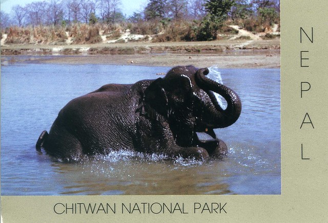
Something a little different now.. This is one of the only postcards of Nepal I have. Sadly it wasn't mailed directly from Nepal, but you can't have everything I suppose.. and the Slovenian stamps on this card are lovely!
Chitwan National Park is the first national park in Nepal. Formerly called Royal Chitwan National Park it was established in 1973 and granted the status of a World Heritage Site in 1984. It covers an area of 932 km2 and is located in the subtropical Inner Terai lowlands of south-central Nepal in the Chitwan District. In altitude it ranges from about 100 metres in the river valleys to 815 metres in the Churia Hills.
In the north and west of the protected area the Narayani-Rapti river system forms a natural boundary to human settlements. Adjacent to the east of Chitwan National Park is Parsa Wildlife Reserve, contiguous in the south is the Indian Tiger Reserve Valmiki National Park. The coherent protected area of 2,075 km2 represents the Tiger Conservation Unit (TCU) Chitwan-Parsa-Valmiki, which covers a 3,549 km2 huge block of alluvial grasslands and subtropical moist deciduous forests.
Chitwan National Park is the first national park in Nepal. Formerly called Royal Chitwan National Park it was established in 1973 and granted the status of a World Heritage Site in 1984. It covers an area of 932 km2 and is located in the subtropical Inner Terai lowlands of south-central Nepal in the Chitwan District. In altitude it ranges from about 100 metres in the river valleys to 815 metres in the Churia Hills.
In the north and west of the protected area the Narayani-Rapti river system forms a natural boundary to human settlements. Adjacent to the east of Chitwan National Park is Parsa Wildlife Reserve, contiguous in the south is the Indian Tiger Reserve Valmiki National Park. The coherent protected area of 2,075 km2 represents the Tiger Conservation Unit (TCU) Chitwan-Parsa-Valmiki, which covers a 3,549 km2 huge block of alluvial grasslands and subtropical moist deciduous forests.
Montenegro
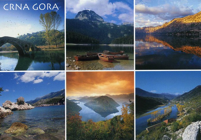
More natural beauty, this time from Montenegro. This is one of the many gorgeous postcards my dear Snježana sent me after visiting Montenegro last year. Thank you so much!! I have no idea what any of the places on this card are, but they are really beautiful nonetheless.
Montenegro is a country located in Southeastern Europe. It has a coast on the Adriatic Sea to the south-west and is bordered by Croatia to the west, Bosnia and Herzegovina to the northwest, Serbia to the northeast, Albania to the southeast, and Kosovo to the east. Its capital and largest city is Podgorica, while Cetinje is designated as the Prijestonica, meaning the former Royal Capital City.
From 1918, Montenegro was a part of Yugoslavia. On the basis of a referendum held on 21 May 2006, Montenegro declared independence on 3 June of that year.
Montenegro is classified by the World Bank as a middle-income country. Montenegro is a member of the UN, the World Trade Organization, the Organization for Security and Co-operation in Europe, the Council of Europe, the Central European Free Trade Agreement and a founding member of the Union for the Mediterranean. Montenegro is currently an official candidate for membership in the European Union and official candidate for membership in NATO.
Montenegro is a country located in Southeastern Europe. It has a coast on the Adriatic Sea to the south-west and is bordered by Croatia to the west, Bosnia and Herzegovina to the northwest, Serbia to the northeast, Albania to the southeast, and Kosovo to the east. Its capital and largest city is Podgorica, while Cetinje is designated as the Prijestonica, meaning the former Royal Capital City.
From 1918, Montenegro was a part of Yugoslavia. On the basis of a referendum held on 21 May 2006, Montenegro declared independence on 3 June of that year.
Montenegro is classified by the World Bank as a middle-income country. Montenegro is a member of the UN, the World Trade Organization, the Organization for Security and Co-operation in Europe, the Council of Europe, the Central European Free Trade Agreement and a founding member of the Union for the Mediterranean. Montenegro is currently an official candidate for membership in the European Union and official candidate for membership in NATO.
Store Trolltind & Trollfjord, Norway
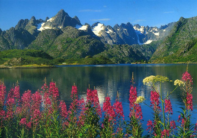
A GORGEOUS Norway view from a swap earlier this year. Thank you so much, Sissel, I absolutely adore this card!
Store Trolltind is the highest point along the Trolltindane ridge. It has the vertical Trollveggen cliff separating the peak from the Romsdalen valley below, a drop of about 1,700 metres which makes it the highest vertical cliff in Europe.
The Trollfjord (Trollfjorden) is a 2 km long sidearm of the Raftsund between the Norwegian archipelagos of Lofoten and Vesterålen. With its narrow entrance and steep-sided mountains, Trollfjord cuts westwards from the Raftsundet strait. The name is derived from troll, a figure from Norse mythology.
Store Trolltind is the highest point along the Trolltindane ridge. It has the vertical Trollveggen cliff separating the peak from the Romsdalen valley below, a drop of about 1,700 metres which makes it the highest vertical cliff in Europe.
The Trollfjord (Trollfjorden) is a 2 km long sidearm of the Raftsund between the Norwegian archipelagos of Lofoten and Vesterålen. With its narrow entrance and steep-sided mountains, Trollfjord cuts westwards from the Raftsundet strait. The name is derived from troll, a figure from Norse mythology.
Subscribe to:
Posts (Atom)


Maroon