The Karakoram Highway (KKH) is the highest paved international road in the world, but at its peak at the China-Pakistan border it is only paved on the Chinese side. It connects China and Pakistan across the Karakoram mountain range, through the Khunjerab Pass, at an altitude of 4,693 m as confirmed by both SRTM and multiple GPS readings. It connects China's Xinjiang region with Pakistan's Gilgit-Baltistan and also serves as a popular tourist attraction. Due to its high elevation and the difficult conditions in which it was constructed, it is also referred to as the "Ninth Wonder of the World.
The Hunza Valley, then, is a mountainous valley in the Gilgit-Baltistan region of Pakistan. The Hunza valley is situated to the north of the Hunza River, at an elevation of around 2,500 metres. The territory of Hunza is about 7,900 square kilometres. Aliabad is the main town with Karimabad as a popular tourist destination because of the spectacular scenery of the surrounding mountains like Ultar Sar, Rakaposhi, Bojahagur Duanasir II, Ghenta Peak, Hunza Peak, Passu Peak, Diran Peak and Bublimating (Ladyfinger Peak), all 6,000 metres or higher.
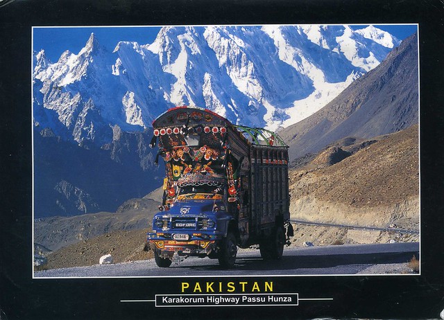
Vera tells me that the car you can see here is a traditional truck decorated with different handmade accessories. She says that all trucks and public busses in Pakistan look like that.


 Maroon


")


No comments:
Post a Comment