Thursday, 10 May 2012

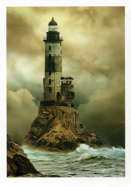
Aniva Lighthouse, Sakhalin, Russia

I've got a bit of a random mix for today, starting off with this great lighthouse postcard I received from a swap last year. I think it's my only postcard of Sakhalin, too.


According to the text on the back of this card, this is the Aniva Lighthouse in Sakhalin, by the Sea of Okhotsk. Sakhalin is a large island in the North Pacific, lying between 45°50' and 54°24' N. It is part of Russia, and is Russia's largest island, and is administered as part of Sakhalin Oblast. Sakhalin, which is about one fifth the size of Japan, is just off the east coast of Russia, and just north of Japan.

The indigenous peoples of the island are the Sakhalin Ainu, Oroks, and Nivkhs. Most Ainu relocated to Hokkaidō when the Japanese were displaced from the island in 1949.

Sakhalin was claimed by both Russia and Japan in the course of the 19th and 20th centuries, which led to bitter disputes between the two countries over control of the island.

The Sea of Okhotsk is a marginal sea of the western Pacific Ocean, lying between the Kamchatka Peninsula on the east, the Kuril Islands on the southeast, the island of Hokkaidō to the south, the island of Sakhalin along the west, and a long stretch of eastern Siberian coast (including the Shantar Islands) along the west and north. The northeast corner is Shelikhov Gulf. It is named after Okhotsk, the first Russian settlement in the Far East.

Wednesday, 9 May 2012

Antigua Guatemala, Guatemala

One more card for today.. and it's a new country to my collection! I have admit I know hardly anything about Guatemala, but the place on this card at least looks really pretty. I love all the colourful buildings!


Antigua Guatemala (commonly referred to as just Antigua or la Antigua) is a city in the central highlands of Guatemala famous for its well-preserved Spanish Mudéjar-influenced Baroque architecture as well as a number of spectacular ruins of colonial churches. It has been designated a UNESCO World Heritage Site.

Antigua Guatemala serves as the municipal seat for the surrounding municipality of the same name. It also serves as the departmental capital of Sacatepéquez Department.

The city had a peak population of some 60,000 in the 1770s; the bulk of the population moved away in the late 18th century. Despite significant population growth in the late 20th century, the city had only reached half that number by the 1990s. According to the 2007 census, the city has some 34,685 inhabitants.

Guatemala, then, is a country in Central America bordered by Mexico to the north and west, the Pacific Ocean to the southwest, Belize to the northeast, the Caribbean to the east, and Honduras and El Salvador to the southeast. Its area is 108,890 km2with an estimated population of 13,276,517.

A representative democracy, its capital is Guatemala de la Asunción, also known as Guatemala City. Guatemala's abundance of biologically significant and unique ecosystems contributes to Mesoamerica's designation as a biodiversity hotspot. The former Mayan civilization was a Mesoamerican civilization, which continued throughout the Post-Classic period until the arrival of the Spanish. The Mayas live in Guatemala, Honduras, Belize, the southern part of Mexico and northern parts of El Salvador.

Guatemala became independent from Spain in 1821, joining the Mexican Empire. After it became an independent country in its own right, it was ruled by a series of dictators, assisted by the United Fruit Company. The late 20th century saw Guatemala embroiled in a 36-year-long civil war. Following the war, Guatemala has witnessed both economic growth and successful democratic elections. In the most recent election, held in 2011, Otto Pérez Molina of the Patriotic Party, won the presidency.

Betina, Croatia

Another seaside view, this time from Croatia. Thank you so much Agi for this treat! :) I'd love to spend a holiday in a place like this, mmmm...!


Betina is a village located on the Croatian island of Murter, seven km from Tisno, where a drawbridge connects the island and the mainland. The largest of the Šibenik archipelago islands, and the closest to the mainland, it has been populated since the time of the Illyrians (tribe of Liburns). Remains of the Roman settlement of Colentum as well as many ruins of Roman villas, murals, and mosaic testify to its occupation during the period of the Roman Empire.

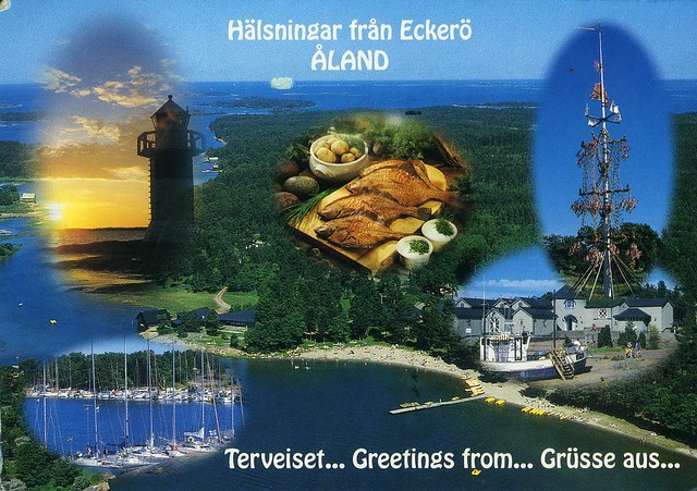
Eckerö, Åland

Another postcard with a lighthouse on it... This one is from MrsTaavi, who visited Finland and a few neighbouring countries last week. I wasn't sure which country she'd send a card from so I was really excited when she picked Åland :)


Eckerö is a municipality of Åland, with a population of 978 (31 January 2012) and covers an area of 752.63 square kilometres of which 644.94 km2 is water. The municipality is unilingually Swedish and 90% of the population are Swedish speakers. It is the westernmost municipality of Åland and Finland. The company Eckerö Linjen operates a ferry connection between Berghamn in Storby, Eckerö and Grisslehamn on Väddö, Norrtälje in Sweden.

The municipality has previously also been known as Ekkerö in Finnish documents, but is today referred to as "Eckerö" also in Finnish.

Eckerö's most famous building is the Post and Customs house. It is the largest and most impressive building that has been erected to aid the postal services between Stockholm and St. Petersburg. The building was built during the Russian times in 1828 and architect C.L Engel made the construction plans.

A lighthouse in Brittany, France

A lovely lighthouse postcard I received as an RAS card last year. I have no idea what this lighthouse is called or where exactly it's located, the postcard only says it's somewhere in Brittany. Heh, and like the sender, Erin, so do I wonder how this kind of photos are taken. The photographer must have a really good zoom in their camera!


Brittany (Bretagne in French) is a cultural region in the north-west of France. Previously a kingdom and then a duchy, Brittany was united to the Kingdom of France in 1532 as a province. Brittany has also been referred to as Less, Lesser or Little Britain (as opposed to Great Britain). Brittany is considered as one of the six Celtic nations.

Brittany occupies the northwest peninsula of continental Europe in northwest France. It is bordered by the English Channel to the north, the Celtic Sea and the Atlantic Ocean to the west, and the Bay of Biscay to the south. Its land area is 34,023 km². The historical province of Brittany is divided into five departments: Finistère in the west, Côtes-d'Armor in the north, Ille-et-Vilaine in the north east, Loire-Atlantique in the south east and Morbihan in the south on the Bay of Biscay.

 In 1956, French regions were created by gathering departments between them. The Region of Brittany comprises, since then, four of the five Breton departments (80% of historical Brittany), while the remaining area of the old Brittany, the Loire-Atlantique department, around Nantes, forms part of the Pays de la Loire region. This territorial organisation is regularly contested. The Kingdom and the Duchy of Brittany, the province of Brittany, and the modern Region of Brittany cover the Western part of Armorica, as it was known during the period of Roman occupation.

In January 2007 the population of historic Brittany was estimated to be 4,365,500. Of these, 71% lived in the region of Brittany, while 29% lived in the region of Pays-de-la-Loire. At the 1999 census, the largest metropolitan areas were Nantes (711,120 inhabitants), Rennes (521,188 inhabitants), and Brest (303,484 inhabitants).

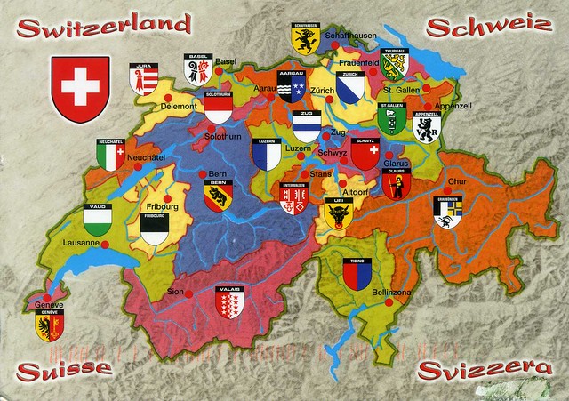
map of Switzerland

I haven't posted a card from Switzerland here for a while so here's one, a great map card I received from Andy (who runs the fab 'I'm going to vacation RR' on the Postcrossing forum).


Switzerland is a federal republic consisting of 26 cantons, with Bern as the seat of the federal authorities. Switzerland is a landlocked country geographically divided between the Alps, the Swiss Plateau and the Jura, spanning an area of 41,285 km2. While the Alps occupy the greater part of the territory, the Swiss population of approximately 8 million people is concentrated mostly on the Plateau, where the largest cities are to be found. Among them are the two global cities and economic centres of Zurich and Geneva.

The Swiss Confederation has a long history of armed neutrality—it has not been in a state of war internationally since 1815—and did not join the United Nations until 2002. It pursues, however, an active foreign policy and is frequently involved in peace-building processes around the world. Switzerland is also the birthplace of the Red Cross and home to a large number of international organizations, including the second largest UN office. On the European level, it is a founding member of the European Free Trade Association and is part of the Schengen Area – although it is notably not a member of the European Union, nor the European Economic Area.

Switzerland comprises three main linguistic and cultural regions: German, French, and Italian, to which the Romansh-speaking valleys are added. The Swiss, therefore, though predominantly German-speaking, do not form a nation in the sense of a common ethnic or linguistic identity. The strong sense of belonging to the country is founded on the common historical background, shared values (federalism and direct democracy) and Alpine symbolism. The establishment of the Swiss Confederation is traditionally dated to 1 August 1291; Swiss National Day is celebrated on the anniversary.

Himeji Castle, Japan

Uh-oh... It's been a while since my last post here, hadn't realised it was quite this long. Days just seem to have disappeared somewhere. ...and the new update page on blogger is really confusing, it could take me a while to get used to this... :S This postcard is from my penpal Asuka in Japan. She actually sent this to me last October and I only just realised I haven't written to her for a while. I'm such a crappy penpal sometimes :S I sent her a postcard, I hope she'll still want to stay in touch. Anyway, she moved to Himeji last year. Himeji Castle is probably the most famous sight there. I love this slighly more unusual view of it.


Himeji Castle is a hilltop Japanese castle complex located in Himeji, in the Hyōgo Prefecture. The castle is regarded as the finest surviving example of prototypical Japanese castle architecture, comprising a network of 83 buildings with advanced defensive systems from the feudal period. The castle is frequently known as Hakuro-jō ("White Egret Castle") or Shirasagi-jō ("White Heron Castle") because of its brilliant white exterior and supposed resemblance to a bird taking flight.

Himeji Castle dates to 1333, when Akamatsu Norimura built a fort on top of Himeyama hill. The fort was dismantled and rebuilt as Himeyama Castle in 1346, and then remodeled into Himeji Castle two centuries later. Himeji Castle was then significantly remodeled in 1581 by Toyotomi Hideyoshi, who added a three-story castle keep. In 1600, Tokugawa Ieyasu awarded the castle to Ikeda Terumasa for his help in the Battle of Sekigahara, and Ikeda completely rebuilt the castle from 1601 to 1609, expanding it into a large castle complex. Several buildings were later added to the castle complex by Honda Tadamasa from 1617 to 1618. For over 400 years, Himeji Castle has remained intact, even throughout the extensive bombing of Himeji in World War II, and natural disasters such as the 1995 Great Hanshin earthquake.

Himeji Castle is the largest and most visited castle in Japan, and it was registered in 1993 as one of the first UNESCO World Heritage Sites in the country. The area within the middle moat of the castle complex is a designated Special Historic Site and five structures of the castle are also designated National Treasures. Along with Matsumoto Castle and Kumamoto Castle, Himeji Castle is considered one of Japan's three premier castles. In order to preserve the castle buildings, it is currently undergoing restoration work that is expected to continue for several years.

Thursday, 12 April 2012

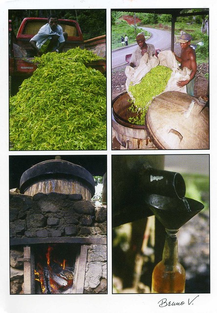
Mayotte

I thought I'd finish off today with a card from a country new to my collection: Mayotte. Ok, this wasn't mailed directly from Mayotte but then it doesn't seem like it's too easy to get postcards from there, so I'm really happy to have this one in my collection at least. ...and what's pictured on this card seems pretty fascinating, I love postcards like this!


The plant pictured here is Cananga odorata, commonly called Ylang-ylang. It's is a tree valued for its perfume. The essential oil derived from the flowers is used in aromatherapy.

Mayotte, then, is an overseas department and region of France consisting of a main island, Grande-Terre (or Mahoré), a smaller island, Petite-Terre (or Pamanzi), and several islets around these two. The archipelago is located in the northern Mozambique Channel in the Indian Ocean, between northwestern Madagascar and northeastern Mozambique. Mayotte's area is 374 square kilometres, and with its estimated 194,000 people is very densely populated (520 /km2). Its biggest city and prefecture is Mamoudzou. The territory is geographically part of the Comoro Islands, but has been politically separate since a 1974 referendum in which it elected to remain under French rule. The territory is also known as Mahoré, the native name of its main island, especially by advocates of its inclusion in the Union of Comoros. In a 2009 referendum, the population overwhelmingly approved accession to status of department (95.2% voted in favour of departmental status). On March 31, 2011, Mayotte became an overseas department.

Changdeokgung, South Korea

This treat from South Korea arrived last month. I really like it - it's such a lovely view and the palace looks so beautiful, and the blossoms at the front really add to it I think. That, and this is still one of the only postcards I've received from South Korea.


Changdeokgung, also known as Changdeokgung Palace, is set within a large park in Jongno-gu, Seoul, South Korea. It is one of the "Five Grand Palaces" built by the kings of the Joseon Dynasty. Because of its location east of Gyeongbok Palace, Changdeokgung, with Changgyeonggung, is also referred to as the "East Palace". The literal meaning of Changdeokgung is "Palace of Prospering Virtue".

Changdeokgung was the most favored palace of many princes of the Joseon Dynasty and retained many elements dating from the Three Kingdoms of Korea period that were not incorporated in the more contemporary Gyeongbokgung. One such element is the fact that the buildings of Changdeokgung blend with the topography of the site instead of imposing upon nature.

Changdeokgung, like the other Five Grand Palaces in Seoul, was heavily damaged during the Japanese occupation of Korea. Currently, only 30% of the Palace structures remain.

Changdeokgung was added to the UNESCO World Heritage List in 1997. The UNESCO committee inscribing the site stated the place was an "outstanding example of Far Eastern palace architecture and garden design" being exceptional because the buildings are "integrated into and harmonized with the natural setting" and adapted "to the topography and retaining indigenous tree cover."

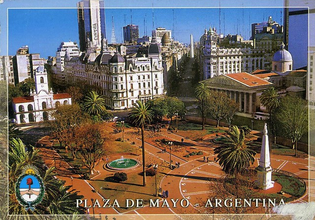
Plaza de Mayo, Buenos Aires, Argentina

Moving on the somewhere warmer.. I'm not sure why but palm trees really fascinate me. ...maybe because they don't grow where I live, at least not proper palm trees? :P This view of Buenos Aires sort of reminds me of Barcelona for some reason as well O_o


Buenos Aires is the capital and largest city of Argentina, and the second-largest metropolitan area in South America, after Greater Sao Paulo. It is located on the western shore of the estuary of the Río de la Plata, on the southeastern coast of the South American continent. Greater Buenos Aires conurbation, which also includes several Buenos Aires Province districts, constitutes the third-largest conurbation in Latin America, with a population of around thirteen million.

The city of Buenos Aires is not a part of Buenos Aires Province, nor is it the Province's capital, but an autonomous district. In 1880, after decades of political infighting, Buenos Aires was federalised and removed from Buenos Aires Province. The city limits were enlarged to include the towns of Belgrano and Flores (both are currently neighborhoods of the city). The 1994 constitutional amendment granted the city autonomy, hence its formal name: Ciudad Autónoma de Buenos Aires (Autonomous City of Buenos Aires). Its citizens first elected a Chief of Government (i.e. Mayor) in 1996; before, the Mayor was directly appointed by the President of the Republic

People from Buenos Aires are referred to as porteños (people of the port). Buenos Aires is a top tourist destination, and is known for its European style architecture and rich cultural life.

The Plaza de Mayo is the main square in the Monserrat barrio of central Buenos Aires, Argentina. It is flanked by Hipólito Yrigoyen, Balcarce, Rivadavia and Bolívar streets. Since being the scene of the 25 May 1810 revolution that led to independence, the plaza has been a hub of political life in Argentina.

Whiteface Mountain, USA

Just a few cards for now as I felt like updating. I'll have to go out in a bit, I really don't want to though as it's so grey and wet outside. I'd much rather stay at home and be all warm and cosy :( It's not like the postcard below makes me feel warm, either, but I really adore it, it's such a beautiful view and the purple tones are gorgeous!


US-1477851


Whiteface Mountain is the fifth-highest mountain in New York State, and one of the High Peaks of the Adirondack Mountains. Set apart from most of the other High Peaks, the summit offers a 360-degree view featuring the Adirondacks and perhaps on a clear day glimpses of Vermont and even Canada. The skyscrapers of Montreal, 130 km away, can be seen on a very clear day. Located in the town of Wilmington (about 21 kilometers from Lake Placid) the mountain is home to a ski area with the highest vertical drop in the eastern United States (1,050 m). Part of the post World War II growth in recreational skiing attributed to the efforts of returning veterans of the Army's 10th Mountain Division, Whiteface also hosted the alpine skiing competition of the 1980 Winter Olympics.

Lake Placid, then, is a village in the Adirondack Mountains. As of the 2000 census, the village had a population of 2,638. Lake Placid is best known as the two-time site of the Winter Olympics, in 1932 and 1980. In the United States, the village is especially remembered as the site of the 1980 USA–USSR hockey game, the so-called Miracle on Ice, when a group of American college students and amateurs upset the heavily favored Soviet national ice hockey team 4–3 and two days later won the gold medal. Another highpoint during the Games was speed-skater Eric Heiden's performance, winning five gold medals.

During the 1932 games, the trails outside of the city served for the cross-country skiing events and the cross-country skiing part of the Nordic combined event. Lake Placid, St. Moritz, Switzerland, and Innsbruck, Austria are the only sites to have twice hosted the Winter Olympic Games.

Wednesday, 11 April 2012

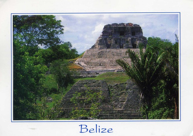
Xunantunich, Belize

One more card for now.. This is the last of the postcards my penpal Lauren sent me from her cruise holiday in the Caribbean earlier this year. She really got to visit some amazing places!


On this postcard you can see Xunantunich, a Maya archaeological site in western Belize, about 130 km west of Belize City, in the Cayo District. Xunantunich is located atop a ridge above the Mopan River, within sight of the Guatemala border. Its name means "Stone Woman" in the Maya language (Mopan and Yucatec combination name), and, like many names given to Maya archaeological sites, is a modern name; the ancient name is currently unknown. The "Stone Woman" refers to the ghost of a woman claimed by several people to inhabit the site, beginning in 1892. She is dressed completely in white, and has fire-red glowing eyes. She generally appears in front of "El Castillo", ascends the stone stairs, and disappears into a stone wall.

Most of the structures date from the Maya Classic Era, about 200 to 900 AD. There is evidence that some structures were damaged by an earthquake while they were occupied; this earthquake may have been a reason for the site's abandonment.

The core of Xunantunich occupies about 2.6 km², consisting of a series of six plazas surrounded by more than 26 temples and palaces. One of its structures, the pyramid known as "El Castillo", the second tallest structure in Belize (after the temple at Caracol), at some 40 m tall. Archeological excavations have revealed a number of fine stucco facades on some of the ancient temples of this site. Evidence of construction suggests the temple was built in three stages in the 7th, 8th, and 9th centuries. The fine stucco or "frieze" are located on the final stage.

The first modern explorations of the site were conducted by Thomas Gann in 1894 and 1895. Several projects of archeological excavations have been conducted at the site from the 1930s through the 1990s.