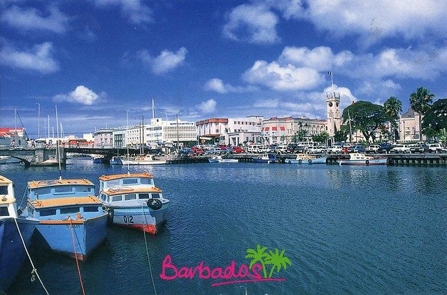
Anyway, this is the card I received earlier this year, showing historic Bridgetown. Bridgetown (metropolitan pop 110,000 (2014)) is the capital and largest city of the nation of Barbados. Formerly, the Town of Saint Michael, the Greater Bridgetown area is located within the parish of Saint Michael. Bridgetown is sometimes locally referred to as "The City", but the most common reference is simply "Town".
The Bridgetown port, found along Carlisle Bay lies on the southwestern coast of the island. Parts of the Greater Bridgetown area (as roughly defined by the Ring Road Bypass or more commonly known as the ABC Highway), sit close to the borders of the neighbouring parishes Christ Church and St. James. The Grantley Adams International Airport for Barbados, is located 16 kilometres southeast of Bridgetown city centre, and has daily flights to major cities in the United Kingdom, United States, Canada and the Caribbean. While there is no longer local municipal government, it is governed as a political constituency within the national Parliament. During the short lived 1950s-1960s Federation of the British West Indian Territories, Bridgetown was one of three capital cities within the region being considered to be the Federal capital of region.
The present day location of the city was established by English settlers in 1628 following a prior settlement under the authority of Sir William Courten at St. James Town. Bridgetown is a major West Indies tourist destination, and the city acts as an important financial, informatics, convention centre, and cruise ship port of call in the Caribbean region. On 25 June 2011, Historic Bridgetown and its Garrison were added as a World Heritage Site of UNESCO.
Barbados is a sovereign island country in the Lesser Antilles. It is 34 kilometres in length and up to 23 kilometres in width, covering an area of 432 square kilometres. It is situated in the western area of the North Atlantic and 100 kilometres east of the Windward Islands and the Caribbean Sea; therein, it is about 168 kilometres east of the islands of Saint Vincent and the Grenadines and 400 kilometres north-east of Trinidad and Tobago. Barbados is outside of the principal Atlantic hurricane belt.
Barbados was visited by Spanish navigators in the late 15th century and claimed for the Spanish Crown. It first appears on a Spanish map from 1511. The Portuguese visited the island in 1536, but they left it unclaimed, with their only remnants being an introduction of wild hogs for a good supply of meat whenever the island was visited. The first English ship, the Olive Blossom, arrived in Barbados in 1624. They took possession of it in the name of King James I. In 1627 the first permanent settlers arrived from England, and it became an English and later British colony.
In 1966, Barbados became an independent state and Commonwealth realm, retaining Queen Elizabeth II as Head of State. It has a population of 277,821 people, mostly of African descent. Despite being classified as an Atlantic island, Barbados is considered to be a part of the Caribbean, where it is ranked as a leading tourist destination. In 2011 Barbados ranked second in the Americas (after Canada) and 16th globally on Transparency International's Corruption Perception Index.
...and this is the other card of Barbados that I have, showing a beach in Batsheba, Saint Joseph. The parish of Saint Joseph is a parish of Barbados on the eastern side of the island. The parish is home to two of the more notable botanic gardens in the country - Flower Forest and Andromeda Gardens. Parts of St. Joseph are also referred to as the Scotland District, a reference to the appearance of the landscape. Bathsheba is the main town in the parish. One of the highest points in the island is Chimborazo in Saint Joseph. Saint Joseph is also the home of the "Soup Bowl" where international surfing competitions are held.














 Maroon


