One more postcard for today... and what a cool card it is! Ivory Coast is one of those places I never thought I'd ever receive a postcard from. Seems I can be lucky sometimes, then! :)
Ivory Coast (officially Côte d'Ivoire) is a country in West Africa. It has an area of 322,462 square kilometres, and borders the countries Liberia, Guinea, Mali, Burkina Faso and Ghana; its southern boundary is along the Gulf of Guinea. The country's population was 15,366,672 in 1998 and was estimated to be 20,617,068 in 2009.
Ivory Coast is a republic with a strong executive power invested in the President. Its de jure capital is Yamoussoukro and the biggest city is the port city of Abidjan. The official language is French, although many of the local languages are widely used, including Baoulé, Dioula, Dan, Anyin and Cebaara Senufo. The main religions are Islam, Christianity (primarily Roman Catholic) and various indigenous religions.
Through production of coffee and cocoa, the country was an economic powerhouse during the 1960s and 1970s in West Africa. However, Ivory Coast went through an economic crisis in the 1980s, leading to the country's period of political and social turmoil. The 21st century Ivoirian economy is largely market-based and relies heavily on agriculture, with smallholder cash crop production being dominant.
Thursday, 23 August 2012
Carnival, Trinidad & Tobago
I receive the vast majority of my postcards through Postcrossing, but I have also been doing some swaps through Facebook recently thanks to Heather's great group there. :) This is one of those cards, received from Nalini in Trinidad & Tobago. Thank you so much!!
The Trinidad and Tobago Carnival is an annual event held on the Monday and Tuesday before Ash Wednesday, and is well known for participant's colorful costumes and exuberant celebrations. Carnival in Trinidad and Tobago is the most significant event on the islands' cultural and tourism calendar, with numerous cultural events running in the lead up to the street parade on Carnival Monday and Tuesday.
The Trinidad and Tobago Carnival is an annual event held on the Monday and Tuesday before Ash Wednesday, and is well known for participant's colorful costumes and exuberant celebrations. Carnival in Trinidad and Tobago is the most significant event on the islands' cultural and tourism calendar, with numerous cultural events running in the lead up to the street parade on Carnival Monday and Tuesday.
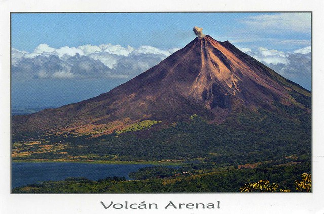
Arenal Volcano and Lake, Costa Rica
I don't have too many postcards from Costa Rica so I'm really happy about this one, even if it wasn't mailed directly from Costa Rica in the end.
Arenal Volcano is an active andesitic stratovolcano in north-western Costa Rica around 90 km northwest of San José, in the province of Alajuela, canton of San Carlos, and district of La Fortuna. The Arenal volcano measures at least 1,633 metres. It is conically shaped with a crater spanning 140 metres. Arenal is geologically considered a young volcano and the age is estimated to be less than 7,000 years. It is also known as "Pan de Azúcar", "Canaste", "Volcan Costa Rica", "Volcan Río Frío" or "Guatusos Peak".
The volcano was dormant for hundreds of years and exhibited a single crater at its summit, with minor fumaroles activity, covered by dense vegetation. In 1968 it erupted unexpectedly, destroying the small town of Tabacón. Due to the eruption three more craters were created on the western flanks but only one of them still exists today. Since October 2010, Arenal's volcanic activity appears to be decreasing and explosions have become rare.
Philadelphia, USA
A great map card I received as an official earlier this year. I love map cards like this!
US-1619150
Philadelphia is the largest city in the Commonwealth of Pennsylvania and the fifth-most-populous city in the United States. It is located in the Northeastern United States along the Delaware and Schuylkill rivers, and it is the only consolidated city-county in Pennsylvania. As of the 2010 Census, the city had a population of 1,526,006.Philadelphia is the economic and cultural center of the Delaware Valley, home to 6 million people and the country's fifth-largest metropolitan area.
Philadelphia is known for its arts and culture. The cheesesteak and soft pretzel are emblematic of Philadelphia cuisine, which is shaped by the city's ethnic mix. The city has more outdoor sculptures and murals than any other American city, and Philadelphia's Fairmount Park is the largest landscaped urban park in the world.
Philadelphia is known for its arts and culture. The cheesesteak and soft pretzel are emblematic of Philadelphia cuisine, which is shaped by the city's ethnic mix. The city has more outdoor sculptures and murals than any other American city, and Philadelphia's Fairmount Park is the largest landscaped urban park in the world.
Zamość, Poland
I received this beautiful postcard from one of my favourite RR's on the Postcrossing forum, the 'Choose a Country' RR hosted by the lovely Peggy. This RR is on holiday mode at the moment but even before that, I haven't been lucky enough to join any groups for a while and I miss it!
Zamość is a town in southeastern Poland with 66,633 inhabitants (2004), situated in the south-western part of Lublin Voivodeship (since 1999). The historical city centre was added to the UNESCO World Heritage List in 1992. In the view of UNESCO, "Zamość is a unique example of a Renaissance town in Central Europe, consistently designed and built in accordance with the Italian theories of the "ideal town," on the basis of a plan which was the result of perfect cooperation between the open-minded founder, Jan Zamoyski, and the outstanding architect, Bernardo Morando.
Zamość is a town in southeastern Poland with 66,633 inhabitants (2004), situated in the south-western part of Lublin Voivodeship (since 1999). The historical city centre was added to the UNESCO World Heritage List in 1992. In the view of UNESCO, "Zamość is a unique example of a Renaissance town in Central Europe, consistently designed and built in accordance with the Italian theories of the "ideal town," on the basis of a plan which was the result of perfect cooperation between the open-minded founder, Jan Zamoyski, and the outstanding architect, Bernardo Morando.
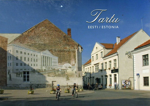
Tartu, Estonia
Moving on, to Finland's southern neighbour, Estonia. I received this postcard from dear Rita earlier this year. She wasn't sure if I'd like this but I definitely do, I think it's a really nice picture - and it has bicycles on it! :D
Tartu is the second largest city of Estonia. In contrast to Estonia's political and financial capital Tallinn, Tartu is often considered the intellectual and cultural hub, especially since it is home to Estonia's oldest and most renowned university. Situated 186 km southeast of Tallinn, the city is the centre of southern Estonia. The Emajõgi river, which connects the two largest lakes of Estonia, crosses Tartu. The city is served by Tartu Airport.
Tartu is the second largest city of Estonia. In contrast to Estonia's political and financial capital Tallinn, Tartu is often considered the intellectual and cultural hub, especially since it is home to Estonia's oldest and most renowned university. Situated 186 km southeast of Tallinn, the city is the centre of southern Estonia. The Emajõgi river, which connects the two largest lakes of Estonia, crosses Tartu. The city is served by Tartu Airport.
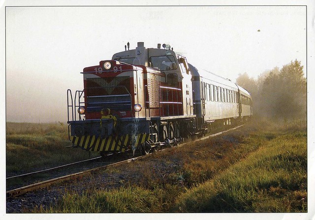
Locomotive, Finland
A wonderful train postcard I received from a swap earlier this year. It came with a matching stamp!
This is an old DV15 locomotive from Finland, used by the state railways, VR ('Valtion rautatiet').
This is an old DV15 locomotive from Finland, used by the state railways, VR ('Valtion rautatiet').
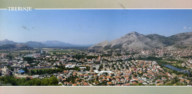
Trebinje, Bosnia & Herzegovina
My dear penpal Snježana has been to a number of places this summer and has been sending me lots of postcards from these places. The postcards she sent me of Trebinje have to be amongst my favourites, here's one of them.
Trebinje is the southernmost municipality and town in Bosnia and Herzegovina, located in southeastern Herzegovina, some 10 km from the Adriatic Sea. The town was first mentioned in the 10th century.
I love the stamps Snježana uses on her envelopes, and these are no expection!
Trebinje is the southernmost municipality and town in Bosnia and Herzegovina, located in southeastern Herzegovina, some 10 km from the Adriatic Sea. The town was first mentioned in the 10th century.
I love the stamps Snježana uses on her envelopes, and these are no expection!
Labels:
2012,
bosnia and herzegovina,
friends,
penpals,
trebinje
Glastonbury, England
Matt's parents visited Glastonbury earlier this summer for some church event. They know how much I love postcards so they brought me back some :)
Glastonbury is a small town in Somerset, England, situated at a dry point on the low lying Somerset Levels, (37 km) south of Bristol. The town, which is in the Mendip district, had a population of 8,784 in the 2001 census.
Glastonbury Abbey, seen here, was a monastery in Glastonbury. The ruins are now a grade I listed building, and a Scheduled Ancient Monument and are open as a visitor attraction. The abbey was founded in the 7th century and enlarged in the 10th, before a major fire in 1184 destroyed the buildings. It was rebuilt and by the 14th century was one of the richest and most powerful monasteries in England.
The Glastonbury Thorn is a form of Common Hawthorn, found in and around Glastonbury, Somerset, England. Unlike ordinary hawthorn trees, it flowers twice a year, the first time in winter and the second time in spring. The trees in the Glastonbury area have been propagated by grafting since ancient times. It is associated with legends about Joseph of Arimathea and the arrival of Christianity in Britain, and has appeared in written texts since the medieval period.
Sunday, 19 August 2012
Bonaire
One more card for today.. and it's a new country in my collection! Bonaire is one of those places I hadn't even heard of before joining Postcrossing.
Bonaire is a special municipality (officially public body) of the Netherlands, consisting of the Caribbean island of Bonaire and, nestled in its western crescent, the uninhabited islet of Klein Bonaire. Together with Aruba and Curaçao it forms a group referred to as the ABC islands of the Leeward Antilles, the southern island chain of the Lesser Antilles. The name Bonaire is thought to have originally come from the Caiquetio word 'Bonay'. The early Spanish and Dutch modified its spelling to Bojnaj and also Bonaire, which means "Good Air".
Bonaire was part of the Netherlands Antilles until the country's dissolution on 10 October 2010, when the island (including Klein Bonaire) became a special municipality within the country of the Netherlands.
This postcard shows Ceru Bentana in the Washington-Slagbaai National Park. Ceru Bentana (the "Window in the Hill"), a striking natural monument in the park, is surrounded by native plants like the towering Kadushi cactus.
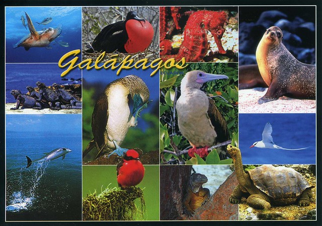
Galápagos Islands
This WONDERFUL postcard is from a swap with dear Jane earlier this year. Thank you so much!
Situated in the Pacific Ocean some 1,000 km from the South American continent, these 19 islands and the surrounding marine reserve have been called a unique ‘living museum and showcase of evolution’. Located at the confluence of three ocean currents, the Galápagos are a ‘melting pot’ of marine species. Ongoing seismic and volcanic activity reflects the processes that formed the islands. These processes, together with the extreme isolation of the islands, led to the development of unusual animal life – such as the land iguana, the giant tortoise and the many types of finch – that inspired Charles Darwin’s theory of evolution by natural selection following his visit in 1835.
The Galápagos Islands and its surrounding waters form an Ecuadorian province, a national park, and a biological marine reserve. The principal language on the islands is Spanish. The islands have a population of slightly over 25,000.
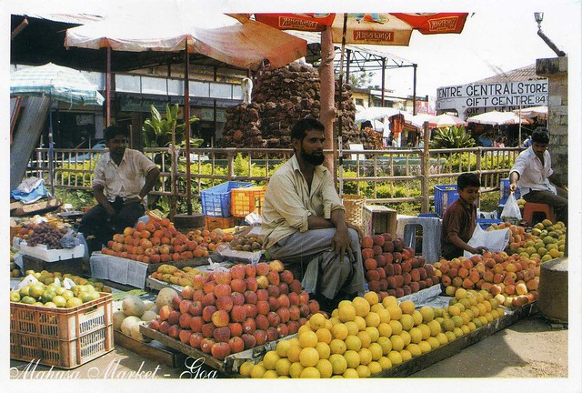
Fruit Market, Goa, India
I still don't have that many postcards from India so this was a very welcome addition to my little collection. I really love these market views, they are so lively and colourful!
Here you can see a fruit market in Mapusa, a town in North Goa, India. The sender, 'Nimrodnomad', tells me you must be very good in bargaining around these markets to get a good deal. They wouldn't be any good for me, then :P
Here you can see a fruit market in Mapusa, a town in North Goa, India. The sender, 'Nimrodnomad', tells me you must be very good in bargaining around these markets to get a good deal. They wouldn't be any good for me, then :P
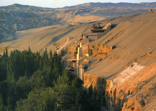
Mogao Caves, China
Moving on to Asia.. This beautiful view is an official I received from China earlier this year. ..and it's a Unesco site, too!
CN-552453
The Mogao Caves form a system of 492 temples 25 km southeast of the center of Dunhuang, an oasis strategically located at a religious and cultural crossroads on the Silk Road, in Gansu province, China. The caves contain some of the finest examples of Buddhist art spanning a period of 1,000 years. The first caves were dug out 366 AD as places of Buddhist meditation and worship.
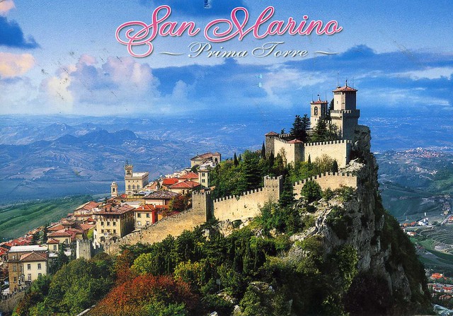
First Tower, San Marino
One more card from Europe for today, this time from San Marino. This one arrived with absolutely AMAZING stamps!
The Three Towers of San Marino are a group of towers located in the small European country of San Marino. Located on the three peaks of Monte Titano in the capital, also called San Marino, they are depicted on both the national flag and coat of arms. San Marino also has a cake known as La Torta Di Tre Monti (Cake of the Three Mountains/Towers), as a symbol for the area, it is a layered wafer cake covered in chocolate. On this postcard you can see the First Tower (Guiata), the oldest of the three towers, and the most famous. It was constructed in the 11th century and served briefly as a prison.
The Three Towers of San Marino are a group of towers located in the small European country of San Marino. Located on the three peaks of Monte Titano in the capital, also called San Marino, they are depicted on both the national flag and coat of arms. San Marino also has a cake known as La Torta Di Tre Monti (Cake of the Three Mountains/Towers), as a symbol for the area, it is a layered wafer cake covered in chocolate. On this postcard you can see the First Tower (Guiata), the oldest of the three towers, and the most famous. It was constructed in the 11th century and served briefly as a prison.
Cote d'Azur, France
A wonderful view from the French Riviera, thank you Perfecta!
The Côte d'Azur, often known in English as the French Riviera, is the Mediterranean coastline of the southeast corner of France, also including the sovereign state of Monaco. There is no official boundary, but it is usually considered to extend from the Italian border in the east to Saint Tropez, Hyères, Toulon or Cassis in the west. This coastline was one of the first modern resort areas.
The Côte d'Azur, often known in English as the French Riviera, is the Mediterranean coastline of the southeast corner of France, also including the sovereign state of Monaco. There is no official boundary, but it is usually considered to extend from the Italian border in the east to Saint Tropez, Hyères, Toulon or Cassis in the west. This coastline was one of the first modern resort areas.
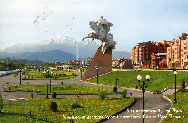
Vladikavkaz, Ossetia, Russia
I'm trying to collect a viewcard of all different regions of Russia. I still have a number of regions missing but I'm slowly getting there. :)
This view is from Vladikavkaz, the capital city of the Republic of North Ossetia–Alania in southern Russia. It is located in the southeast of the republic at the foothills of the Caucasus Mountains, situated on the Terek River. Population: 311,635 (2010 Census preliminary results). Vladikavkaz is one of the most populous cities in the North Caucasus. The city is an industrial and transportation center. Manufactures include processed zinc and lead, machinery, chemicals, clothing, and food products.
On this card you can see River Terek embankment and the Issa Pliev monument (the Hero of the USSR).
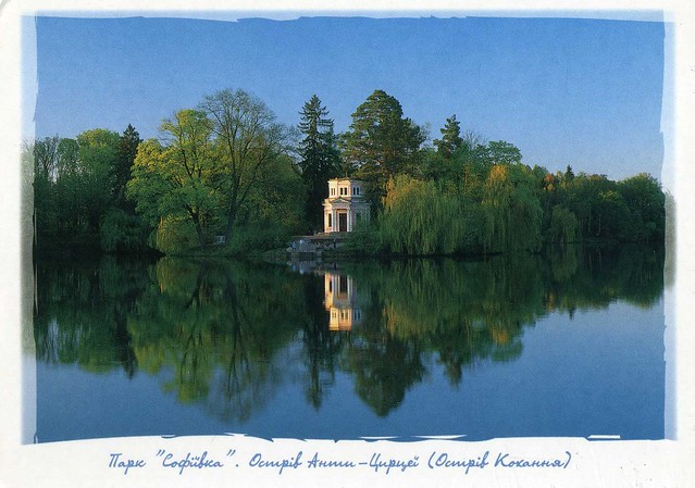
Sofiivka Park, Uman, Ukraine
Another official, this time from Ukraine. What a beautiful, tranquil view!
UA-306330
The island of Anta-Circe (The Island of Love) in Sofiivka Park in Uman, Ukraine. The sender, Helen, tells me it's a great place to visit, especially in the autumn.
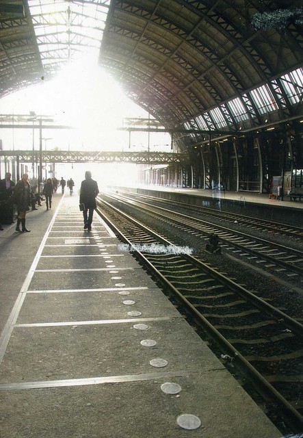
Railway Station, Amsterdam, The Netherlands
I'm starting to get REALLY behind with this blog and have a massive pile of postcards I want to post here, so I thought I'd change my approach a bit, at least for a bit. That is, including a lot less text or descriptions of cards, instead mainly just posting pictures of postcards and stamps. Let's see how that'll go...
I thought I'd start with this official I received earlier this year from the Netherlands.
NL-1270953
A railway station in Amsterdam, the Netherlands. I love the light here!
I thought I'd start with this official I received earlier this year from the Netherlands.
Labels:
2012,
amsterdam,
officials,
railway stations,
the netherlands,
trains
Wednesday, 1 August 2012
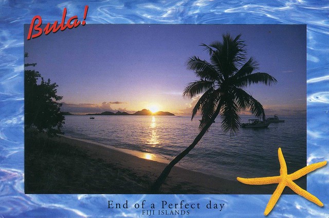
Fiji
Last week it was really sunny and warm here in England, a proper summer. Now it's back to the usual rain and cooler weather, meh :/ I wouldn't want it to be super hot all the time, but I still wouldn't mind a bit more sunshine and warm days when I could go outside in a t-shirt. :P
Those warm days also make me dream of spending time on a beach. English beaches aren't quite like the tropical paradise on the card below, though :P It really does look like the end of a perfect day, I wouldn't mind visiting somewhere like that! I'm really excited to have my first postcard received from Fiji, too - thanks a million Keith!
Fiji is an island nation in Melanesia in the South Pacific Ocean about 2,000 km northeast of New Zealand's North Island. Its closest neighbours are Vanuatu to the west, France's New Caledonia to the southwest, New Zealand's Kermadec to the southeast, Tonga to the east, the Samoas, France's Wallis and Futuna to the northeast and Tuvalu to the north.
The majority of Fiji's islands were formed through volcanic activity started around 150 million years ago. Today, some geothermal activity still occurs on the islands of Vanua Levu and Taveuni. Fiji has been inhabited since the second millennium BC. The country comprises an archipelago of more than 332 islands, of which 110 are permanently inhabited, and more than 500 islets, amounting to a total land area of circa 18,300 square kilometres. The two major islands, Viti Levu and Vanua Levu, account for 87% of the population of almost 850,000. The former contains Suva, the capital and largest city. Most of Fijians live on Viti Levu's coasts, either in Suva or in smaller urban centres. Viti Levu's interior is sparsely inhabited due to its terrain.
Because of the abundance of forest, mineral, and fish resources, Fiji is one of the most developed economies in the Pacific island realm. Today, the main sources of foreign exchange are its tourist industry and sugar exports. The country's currency is the Fijian dollar.
Sheikh Zayed Grand Mosque, Abu Dhabi, United Arab Emirates
It is Ramadan at the moment so I thought I'd post something relating to it, and thought a mosque postcard would be appropriate. For some reason I find mosque postcards really fascinating - these buildings always look so impressive and beautiful, with lots of details.
As you can read on the card above, Abu Dhabi's grand mosque is one of the largest mosques in the world and can accommodate more than 30,000 worshippers. Aisha, who sent me this card, tells me that Aladdin's palace from the Disney cartoon was inspired by this mosque! Inside the mosque is heavily ornated with 24Kt gold.
The mosque's design and construction 'unites the world', using artisans and materials from many countries including Italy, Germany, Morocco, India, Turkey, Iran, China, United Kingdom, New Zealand, Greece and of course the United Arab Emirates. More than 3,000 workers and 38 renowned contracting companies took part in the construction of the mosque. Natural materials were chosen for much of its design and construction due to their long-lasting qualities, including marble, stone, gold, semi-precious stones, crystals and ceramics. Construction began on November 5, 1996.
Bratislava, Slovakia
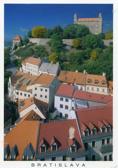
I just realised there's only one postcard from Slovakia in this blog so far.. well, here's another one :) ..and a really nice one, too, the old houses look so pretty!
Bratislava is the capital of Slovakia and, with a population of about 460,000, also the country's largest city. Bratislava is in southwestern Slovakia on both banks of the Danube River and on the left bank of Morava river. Bordering Austria and Hungary, it is the only national capital that borders two independent countries.
Bratislava is the political, cultural, and economic centre of Slovakia. It is the seat of the Slovak president, the parliament, and the Slovak Executive. It is home to several universities, museums, theatres, galleries and other important cultural and educational institutions. Many of Slovakia's large businesses and financial institutions also have headquarters there.
The history of the city has been strongly influenced by people of different nations and religions, namely by Austrians, Czechs, Germans, Hungarians, Slovaks, and Jews. The city was the capital of the Kingdom of Hungary, a part of the larger Habsburg Monarchy territories, from 1536 to 1783 and has been home to many Slovak, Hungarian, and German historical figures.
Ćevapi, Bosnia & Herzegovina
I really like food-related postcards but for some reason don't post them in this blog too often.. hhmmmm... This one is from my dear Snježana. Makes me hungry!
Ćevapi is a grilled dish of minced meat, a type of kebab, found traditionally in the countries of southeastern Europe. They are considered a national dish in Bulgaria, Bosnia and Herzegovina and in Serbia. They are also common in Croatia, Montenegro, Kosovo, Slovenia, as well as in Republic of Macedonia, Romania, Czech Republic, Slovakia, Austria and the Italian provinces bordering Slovenia.
They are usually served of 5-10 pieces on a plate or in a flatbread (lepinje or somun), often with chopped onions, sour cream, kajmak, ajvar, cottage cheese, minced red pepper and salt. Serb ćevapčići are made of either beef, lamb or pork or mixed. Bosnian ćevapi are made from two types of minced beef meat, hand mixed and formed with a funnel, while formed ćevapi are grilled. Macedonian, Croatian, Bulgarian and Romanian varieties are often made of both pork and beef. (This is from Wikipedia, correct me if I'm wrong.)
I tried making some ćevapi at home a few weeks ago. I have no idea if it was authentic at all but it was definitely very, very tasty. If anyone reading this has a recipe for proper ćevapi, I'd be more than happy to have it!! (*hint hint*)
Labels:
2012,
bosnia and herzegovina,
food and drinks,
friends,
penpals,
sarajevo
The Isle of Wight, England
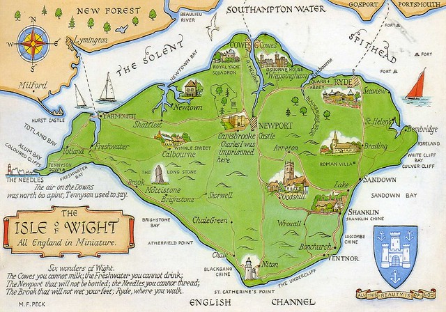
More postcards bringing back memories, this time from England. This is from a favourites swap with dear Jane. Back in 1998 (it's been so long!) I went on a language course on the Isle of Wight, and while it wasn't always too fantastic, I still really liked it there and got to visit lots of wonderful places and experience a bit of English life. My host family (a couple in their 20s with two (or three?) small children) lived in East Cowes, right in the north of the island in a terraced house, which at the time I thought was really fascinating (maybe that's partly why I still wouldn't mind living in one??). I remember visiting Ryde a few times, as well as Newport, plus Sandown, Shanklin and Alum Bay, possibly other places as well (Ventnor sounds familiar).
The Isle of Wight is a county and the largest island in England, located in the English Channel, on average about 3–7 km off the south coast of the county of Hampshire, separated from the mainland by a strait called the Solent. The Island has many resorts which have been holiday destinations since Victorian times.
The Island has a rich history, including a brief status as an independent kingdom in the 15th century. Until 1995, like Jersey and Guernsey, the Island had its own Governor—most notably Lord Mountbatten from 1969 to 1974, after which he became Lord Lieutenant until his assassination in 1979.
The Isle of Wight was home to the poets Swinburne and Tennyson, and to Queen Victoria, who built her much-loved summer residence and final home Osborne House at East Cowes. The Island's maritime and industrial history encompasses boat building, sail making, the manufacture of flying boats, the world's first hovercraft and the testing and development of Britain's space rockets. It is home to the Isle of Wight International Jazz Festival, Bestival and the recently revived Isle of Wight Festival, which, in 1970, was the largest rock music event ever held. The Island has some exceptional wildlife and is one of the richest locations of dinosaur fossils in Europe.
Lake Saimaa, Finland
Uh-oh... Almost a month has passed since my last update.. oops. July was a pretty darn good month, though. In early July I attended the annual Aikido Summer School in Birmingham (only two days this year because of the Olympics), which was a much bigger deal for me this year as I had my black belt exam there. I was really, really nervous, but it went a lot better than I expected - and I passed! Not only that, but I got to skip the usual few months' probationary period and was awarded full 1st Dan black belt straightaway, which means I can already wear a black belt and a hakama! It still feels a little unreal at times and I stress so much about folding the hakama.. :P I'm really happy, though, and super relieved.
After the Summer School me and Matt were off to Finland for a week, to see my family. I'd been wanting to spend some time with my family (a close relative of mine passed away this spring..) and I got to do that, and see familiar places again. We spent most of the week with my parents in my old home town, Lappeenranta and I had a great time. I definitely needed this break!
Lappeenranta is located by lake Saimaa, the largest lake in Finland. ...which is pictured in this postcard I received from a swap earlier this summer. The Finnish Post issued a set of postcards with pictures of old travel adverts. This one has got to be my favourite because it brings back so many memories.
Saimaa is a lake in southeastern Finland. At approximately 4,400 square kilometres, it is the largest lake in Finland, and the fourth largest in Europe. It was formed by glacial melting at the end of the Ice Age. Major towns on the lakeshore include Lappeenranta, Imatra, Savonlinna, Mikkeli, Varkaus, and Joensuu. The Vuoksi River flows from Saimaa to Lake Ladoga. Most of the lake is spotted with islands, and narrow canals divide the lake in many parts, each having their own names (major basins include Suur-Saimaa, Orivesi, Puruvesi, Haukivesi, Yövesi, Pihlajavesi, and Pyhäselkä).
The Saimaa Canal from Lappeenranta to Vyborg connects Saimaa to the Gulf of Finland. Other canals connect Saimaa to smaller lakes in Eastern Finland and form a network of waterways. These waterways are mainly used to transport wood, minerals, metals, pulp and other cargo, but also tourists use the waterways.
One of the rare and endangered freshwater seals, the Saimaa Ringed Seal, lives only at Saimaa. Also, the Saimaa salmon is another endangered species in the same habitat.
Subscribe to:
Comments (Atom)





















 Maroon


