Saturday 24 December 2011

Merry Christmas!


Have a lovely Christmas if you celebrate it!

Saturday 17 December 2011

The Khibiny Mountains, Russia

Today's last card is one of the many beautiful postcards I received from Andrey in Russia from a swap earlier this year. It's so difficult to choose which Russian postcards to post in this blog because I have SO many absolutely gorgeous views from there. I picked this one as it's slightly different to most Russian views - I don't tend to associate northern lights with Russia!


The Khibiny Mountains (or The Khibiny Massif) is one of the two main mountain ranges of the Kola Peninsula, Russia, within the Arctic Circle, located between Imandra and Umbozero lakes.

The massif is of oval shape of about 1,300 km2. and occupies the central part of the peninsula at a relative elevation of 900-1000 m above the surrounding plain. The mountains are not particularly high; the two highest peaks are the Yudytchvumtchchorr, which stands 1,201 metres, and the Chasnachorr, which stands 1,191 metres. The average elevation is 1,116 metres. The mountains form the shape of a horseshoe topped by a high plateau, drained by a series of deep canyons. The peaks are of plateau type, with steep slopes, with glaciers, icefields and snowfields in some places. The overall terrain is alpine tundra.

The massif is extremely rich in various minerals, mainly apatite and nepheline ores. 477 valid minerals have been reported and 108 of those are type localities or minerals first described in the Khibiny.

The Khibinskys are mostly uninhabited, except for one of the world's richest mineral quarries, with approximately 10% of all new minerals discovered there, including one that can potentially absorb radioactivity from nuclear waste. The cities of Apatity and Kirovsk are situated at the foot of the massif.

Toronto, Canada

A gorgeous winter view of Nathan Phillip's Square in Toronto I received from my friend Kristen a couple of months ago. I just love the lights here, they look so magical!


Nathan Phillips Square is an urban plaza that forms the forecourt to Toronto City Hall, or New City Hall, at the intersection of Queen Street West and Bay Street, and named for Nathan Phillips, mayor of Toronto from 1955 to 1962. The square opened in 1965, and, as with the City Hall, the square was designed by architect Viljo Revell (a Finnish architect!!). The square is the site of concerts, art displays, a weekly farmers' market, the winter festival of lights, and other public events, including demonstrations.

Hobart, Tasmania

I know I already follow too many tv series, but I just couldn't resist The Mentalist. I'd seen bits and pieces as Matt's parents follow the series and I quite liked what I'd seen, so I thought I'd try watching the first couple of episodes from season 1. ...and now I'm hooked. :P Ooops. Simon Baker (who plays the main character, Patrick Jane) is originally from Australia and was born in Tasmania. ...which looks like a really interesting area and one I don't know too much about.


Hobart is the state capital and most populous city of the Australian island state of Tasmania. Founded in 1804 as a penal colony, Hobart is Australia's second oldest capital city after Sydney. In 2009, the city had a greater area population of approximately 212,019. A resident of Hobart is known as a "Hobartian". The city is located in the state's south-east on the estuary of the Derwent River. The skyline is dominated by Mount Wellington at 1,271 metres high.

The city is the financial and administrative heart of Tasmania, also serving as the home port for both Australian and French Antarctic operations.

Hobart was named Australia's 6th most sustainable city, by the Australian Conservation Foundation in 2010. For economic and social innovation, Hobart was the 11th placed in Australia in 2009, and listed as an innovation influencer city in the Innovation Cities Global Index scoring equal with Reykjavik, Katowice and Casablanca by 2thinknow.

Hissar, Bulgaria

I'm pretty nervous at the moment - tomorrow it'll be Aikido gradings in Birmingham and I'm be going for brown belt. I keep thinking what if my mind goes blank and I just forget everything, or do something stupid... Wish me luck! I'm also a bit worried about actually getting to Birmingham (and then back home) as it's supposed to snow here this weekend and the traffic is always a total chaos if it does. :S ...that, and I wish my friend Miranda was there tomorrow, I could do with some support from her. She's on holiday at the moment, though, back home in Hong Kong and she'll also be visiting Taiwan (and she said she'd bring me back postcards :)). She gets to travel so much! Earlier this year she visited Bulgaria. It wasn't just for fun and relaxation although she did get to do that as well. Anyway, she brought me back a couple of postcards and I thought I'd show one of them here.


Hissar is a small resort town in Bulgaria, in Plovdiv Province. Located in the outskirts of the Sredna Gora mountain range, it boasts of a very mild climate and over two dozen different mineral springs, which make it a favorite spa for many Bulgarian and foreign tourists. The town's population is 7,691. The population of the municipality is approximately 14,826.

Because of these springs, the town was founded thousands of years ago. Some pre-historic remains have been found in what is now the town centre. Later, it became a Thracian city, and when Thrace fell to the Romans and became a Roman province, Hisarya became a Roman town - one of the three most important towns in the province. At various times it was called Augusta, Diocletianopolis (after emperor Diocletian) and a couple of other names. It was a famous resort even in those times, which is proved by the fact that emperor Septimius Severus himself visited the city.

Many Roman ruins are still visible everywhere - public buildings, a small amphitheatre, the barracks of the Roman garrison, the foundations of a couple of the oldest churches in Bulgaria, as well as the best preserved Roman fortress in Bulgaria. The southern gate is known as "The Camels", because it had broken in the middle and looked like two camels facing each other, before it was partially restored in the early 20th century.

Saturday 10 December 2011

Mantenga Cultural Village, Swaziland

One more card for today... and it's a new country to my collection! Well, it wasn't mailed directly from Swaziland but I think that would be a bit too much to ask. This is another treat from the lovely Kim in Taiwan. Thank you so much!


Swaziland, officially the Kingdom of Swaziland, is a landlocked country in Southern Africa, bordered to the north, south and west by South Africa, and to the east by Mozambique. The nation, as well as its people, are named after the 19th century king Mswati II.

Swaziland is a small country, no more than 200 kilometres north to south and 130 kilometres east to west. The western half is mountainous, descending to a lowveld region to the east. The eastern border with Mozambique and South Africa is dominated by the escarpment of the Lebombo Mountains. The climate is temperate in the west, but may reach 40 °C in summer in the lowveld. Rainfall occurs mainly in the summer and may reach 2 metres in the west.

The area that Swaziland now covers has been continuously inhabited since prehistory. Today, the population is primarily ethnic Swazis whose language is siSwati, though English is spoken as a second language. The Swazi people descend from the southern Bantu who migrated from Central Africa in the 15th and 16th centuries. The Anglo Boer war saw the United Kingdom make Swaziland a protectorate under its direct control. Swaziland gained independence in 1968. Swaziland is a member of the Southern African Development Community, the African Union, and the Commonwealth of Nations. The head of state is the king, who appoints the prime minister and a small number of representatives for both chambers of parliament. Elections are held every five years to determine the majority of the representatives. A new constitution was adopted in 2005.

Some 75% of the population are employed in subsistence farming, and 60% of the population live on less than the equivalent of US$1.25 per day. Swaziland's main trading partner is South Africa, and its currency is pegged to the South African rand.


Kim mailed the postcard from Taiwan so the stamps are obviously from Taiwan as well.

Burj Al Arab, Dubai

Dubai is another one of those places where I only have a few postcards from. ...and this is even older than the India postcard - I received this one in 2008!


Burj Al Arab is a 5-star (often misleadingly referred to as 7-star) luxury hotel located in Dubai, United Arab Emirates. At 321 m, it is the fourth tallest hotel in the world. Burj Al Arab stands on an artificial island 280 m out from Jumeirah beach, and is connected to the mainland by a private curving bridge.

Burj Al Arab was designed by British architect Tom Wright of WS Atkins PLC. The design and construction were managed by Canadian engineer Rick Gregory also of WS Atkins. Construction of the Island began in 1994. It was built to resemble the sail of a dhow, a type of Arabian vessel. Two "wings" spread in a V to form a vast "mast", while the space between them is enclosed in a massive atrium. The building opened in December 1999.

Periyar, Kerala, India

Let's stay in Asia for a bit longer, this time moving on to India. I don't know why I hardly ever receive any official Postcrossing cards from there - out of the 1,410 officials I've received, only three are from India. The card here is the latest one of them, and I received it in June 2009! It doesn't even look like India is *that* rare a country anymore, at least if you look at the postcard IDs. Oh well, maybe one day...


IN-7635


Periyar is the longest river in the state of Kerala, India, with a length of 244 km. The Periyar is known as the lifeline of Kerala; it is one of the few perennial rivers in the region and provides drinking water for several major towns. The Idukki Dam on the Periyar generates a significant proportion of Kerala's electrical power.

Kerala is an Indian state located on the Malabar coast of south-west India. It was created on 1 November 1956 by the States Reorganisation Act by combining various Malayalam speaking regions.

The state has an area of 38,863 km2 and is bordered by Karnataka to the north and northeast, Tamil Nadu to the south and southeast, and the Arabian Sea[note] on the west. The city of Thiruvananthapuram is the state capital. Kochi and Kozhikode are other major cities. According to a survey by The Economic Times, five out of ten best cities to live in India are located in Kerala. Kerala is a popular tourist destination for its backwaters, yoga, Ayurvedic treatments and tropical greenery.

Kerala has the highest Human Development Index in India, comparable with that of first world nations but with a much lower per capita income. The state has the highest literacy rate in India with 99 percent. The state recently became and is currently the only one to have banking facilities in every village. A survey conducted in 2005 by Transparency International ranked Kerala as the least corrupt state in the country. Kerala has witnessed significant migration of its people, especially to the Persian Gulf countries during the Kerala Gulf boom and is heavily dependent on remittances from its large Malayali expatriate community.

Lonon Falls, The Philippines

A gorgeous waterfall view I received from the lovely Maerose. I collect waterfall postcards so any new cards are always more than welcome! :)


from the back of the postcard:

LONON FALLS
Lake Sebu, South Cotabato
popularly known as the Seven Falls, it features series of seven waterfalls of majestic cascades lined-up one after the other.


South Cotabato is a province of the Philippines located in the SOCCSKSARGEN region in Mindanao. Its capital is Koronadal City, and it borders Sultan Kudarat to the north and west, Sarangani to the south and east, and Davao del Sur to the east. To the southeast lies Sarangani Bay.

General Santos City, on the shores of Sarangani Bay, is the largest and most important city in the region, and is a major seaport. The province of Sarangani used to be part of South Cotabato until it was made an independent province in 1992.

Kununurra, Western Australia

No snow here so far, I hope it'll stay that way. ...although it's still pretty chilly and I think I've managed to get ill. I've been sneezing and my nose has been running like silly since yesterday, not cool. I really wouldn't mind being somewhere warm and sunny right now... *sigh* Since that's not possible, today's postcards are all from faraway, warm places. The first card is from Heather, a wonderful person and one of my favourite swappers. It's always a pleasure to find a postcard from her in my mailbox.


Kununurra is a town in far northern Western Australia located at the eastern extremity of the Kimberley Region approximately 37 kilometres from the border with the Northern Territory. Kununurra was initiated to service the Ord River Irrigation scheme.

Kununurra is the largest town in Western Australia north of Broome, with the closest town being Wyndham, 100 kilometres away. Kununurra is 3,040 kilometres from Perth via the Great Northern Highway (distances in Australia never cease to amaze me!!).

The town is situated in among the scenic hills and ranges of the far north-east Kimberley Region, having an abundance of fresh water, conserved by the Ord River Diversion dam and the main Ord River Dam.

On this postcard you can see Elephant Rock, situated on the Ord River. Elephant Rock is also known as Sleeping Buddha, and it's one of the several spectacular backdrops to the town of Kununurra.


I love food-themed stamps and these are AMAZING!

Thursday 8 December 2011

Longyearbyen, Svalbard, Norway

Today's last card made me really excited when I received it. When I had joined the RR on the Postcrossing forum, I didn't realise Spitsbergen was in Svalbard and I never thought I'd ever get a postcard from there. ...and then this gem arrived! :)


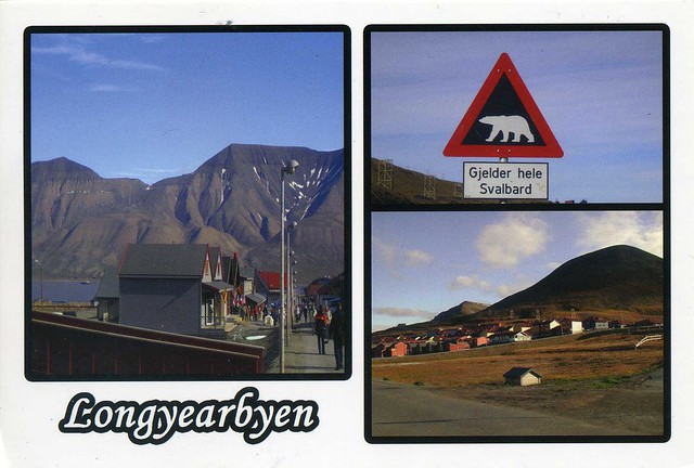
Longyearbyen is the largest settlement and the administrative centre of Svalbard, Norway. It is located on the western coast of Spitsbergen, the largest island of the Svalbard archipelago, on the southern side on Adventfjorden , which continues inland with Adventdalen . The Governor of Svalbard and his administration reside in Longyearbyen.

Longyearbyen has approximately 2,060 inhabitants (at the end of 2007). It is the world's most northerly town, and the most northerly settlement with a population greater than 1,000.

Svalbard is an archipelago in the Arctic, constituting the northernmost part of Norway. It is located north of mainland Europe, midway between mainland Norway and the North Pole. The group of islands range from 74° to 81° north latitude (inside the Arctic Circle), and from 10° to 35° east longitude. Spitsbergen is the largest island, followed by Nordaustlandet and Edgeøya. The administrative center is Longyearbyen, and other settlements include the Russian mining community of Barentsburg, the research community of Ny-Ålesund and the mining outpost of Sveagruva. The archipelago is administered by the Governor of Svalbard.

The islands were first utilized as a whaling base in the 17th and 18th centuries, after which they were abandoned. Coal mining started at the beginning of the 20th century, and several permanent communities were established. The Spitsbergen Treaty of 1920 recognizes Norwegian sovereignty, and the 1925 Svalbard Act made Svalbard a full part of the Kingdom of Norway. This act also established Svalbard as a free economic zone and a demilitarized zone. The Norwegian Store Norske and the Russian Arktikugol are the only mining companies remaining on the islands. Research and tourism have become important supplementary industries. Two major research facilities are the University Centre in Svalbard and the Svalbard Global Seed Vault. No roads connect the settlements; instead snowmobiles, aircraft and boats serve inter-community transport. Svalbard Airport, Longyear serves as the main gateway to the rest of Europe.

The archipelago features an Arctic climate, although with significantly higher temperatures than other areas at the same latitude. The flora take advantage of the long period of midnight sun to compensate for the polar night. Svalbard is a breeding ground for many seabirds, and also features polar bears, reindeer and marine mammals. Seven national parks and twenty-three nature reserves cover two-thirds of the archipelago, protecting the largely untouched, yet fragile, nature. Sixty percent of the archipelago is glacier, and the islands feature many mountains and fjords.

Hundertwasserhaus, Vienna, Austria

More snowy views, this time from Austria. I'd been wanting a postcard of this particular house for ages and finally got one in a tag earlier this year, yay! It's just so gorgeously colourful and whimsical, what's not to love about it?!


Hundertwasserhaus is an apartment house in Vienna, Austria, built after the idea and concept of Austrian artist Friedensreich Hundertwasser with architect Joseph Krawina as a co-author. This expressionist landmark of Vienna is located in the Landstraße district on the corner of Kegelgasse and Löwengasse.

The house was built between 1983 and 1985 according to the ideas and concepts of Hundertwasser with architect Univ.-Prof. Joseph Krawina as a co-author and architect Peter Pelikan as a planner. It features undulating floors ("an uneven floor is a divine melody to the feet"), a roof covered with earth and grass, and large trees growing from inside the rooms, with limbs extending from windows. Hundertwasser took no payment for the design of the house, declaring that it was worth it, to prevent something ugly from going up in its place.

Within the house there are 52 apartments, four offices, 16 private terraces and three communal terraces, and a total of 250 trees and bushes. The Hundertwasser House is one of Vienna's most visited buildings and has become part of Austria's cultural heritage.

Newfoundland, Canada

A small update for a Thursday afternoon before I have to leave for today's aikido class (I'm getting pretty nervous as it's gradings on Sunday next week and I'll be going for brown belt. Wish me luck!). Weather reports are suggesting it could be a really chilly weekend with possibly some snow on its way too, although I do hope it won't reach the West Midlands :P Have some snow on this postcard instead.


CA-189174


Newfoundland is the easternmost province of Canada. Situated in the country's Atlantic region, it incorporates the island of Newfoundland and mainland Labrador (located Northwest of the island) with a combined area of 405,212 square kilometres. As of April 2011, the province's estimated population is 508,400. Approximately 94 percent of the province's population resides on the Island of Newfoundland (including its associated smaller islands), of which over half live on the Avalon Peninsula. The Island of Newfoundland has its own dialects of English, French, and Irish. The English dialect in Labrador is similar to that of Newfoundland. Labrador also has its own dialects of Innu-aimun and Inuktitut.

Newfoundland and Labrador's capital and largest city, St. John's, is Canada's 20th-largest Census Metropolitan Area, and is home to nearly 40 percent of the province's population. St. John's is the seat of government, home to the House of Assembly of Newfoundland and Labrador and the highest court in the jurisdiction, the Newfoundland and Labrador Court of Appeal. A former colony and dominion of the United Kingdom, Newfoundland and Labrador became the tenth province to enter the Canadian Confederation on March 31, 1949, as Newfoundland.

Newfoundland and Labrador is home to a variety of climates and weather. One of the main reasons for this diversity is the geography of the province. The province spans 5.5 degrees of latitude, which is comparable to that of the Great Lakes. The province has been divided into six climate types, but in broader terms Newfoundland has a cool summer subtype of a humid continental climate, which is greatly influenced by the sea since no part of the island is more than 100 km from the ocean. Northern Labrador is classified as a polar tundra climate, southern Labrador have a subarctic climate.