Thursday, 29 August 2013

Sandcastle, Lappeenranta, Finland

So yeah, I went to Finland earlier this month to see my family. I had such a lovely time, it was great to see my parents and sister and some relatives as well again. I just wish I could've stayed a bit longer... I miss it there now a bit. :( Anyway, I spent a day in Helsinki so I got to see my sister, and also visited Valkeakoski to see some relatives (and had a very brief visit to Tampere as my dad bought me a new camera and they didn't have it in stock in Helsinki so he got it from Tampere instead :), but I spent most of the time in Lappeenranta with my parents. It's always so good to see all the old familiar places there!


One evening me and dad bicycled to the harbour (one of my favourite areas in Lappeenranta btw, and I also discovered that I really enjoy bicycling and miss that a lot now as well) to take photos. They've had a massive sandcastle there for some years now, every year with a different theme. This time it was 'the Kalevala' (the national epic of Finland), which I thought was pretty cool. The following bit is from their website:  

Finland’s largest sandcastle in Lappeenranta is built for the tenth time. For the fourth year running it will be designed by children. This year’s theme is "Kalevala". The Kalevala is a 19th-century work of epic poetry compiled by Elias Lönnrot from Finnish and Karelian oral folklore and mythology. Since it is regarded as the national epic of Finland and is one of the most significant works of Finnish literature, you can see in this year Sandcastle a piece of Finland's mythological history. Miniature models designed by children will be displayed next to the Sandcastle. The castle has been built of some 3 million kilos of sand and there is more at the gigantic sand pit, so try your hand and craft your own piece of art!

Sunday, 4 August 2013

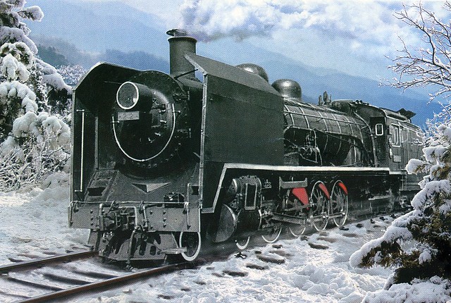
North Korea

This card took some effort to receive, and I have two people to thank for this one: Gisela for sending it, and dear Heather for forwarding it onto me after Gisela couldn't send any mail directly to Europe, so I could still get a written & stamped card from North Korea. :)


I have no idea what sort of train this is or anything else about it, there's no info on the back of the card at all. ...but it certainly adds to my collection of train postcards! ;)

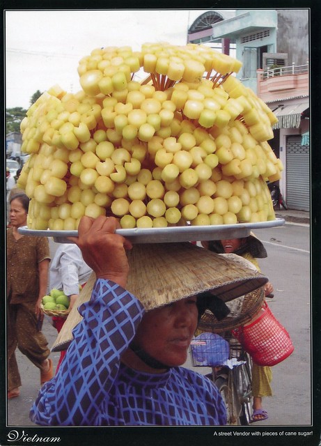
a street vendor, Vietnam

Most of my Vietnam postcards are from Jo; I've had some real treats from her. This one is from a swap in 2009.


I don't have much to say about this card except that I really like it, it's always great to see postcards showing ordinary people. I wonder how heavy that tray of sugar cane is...

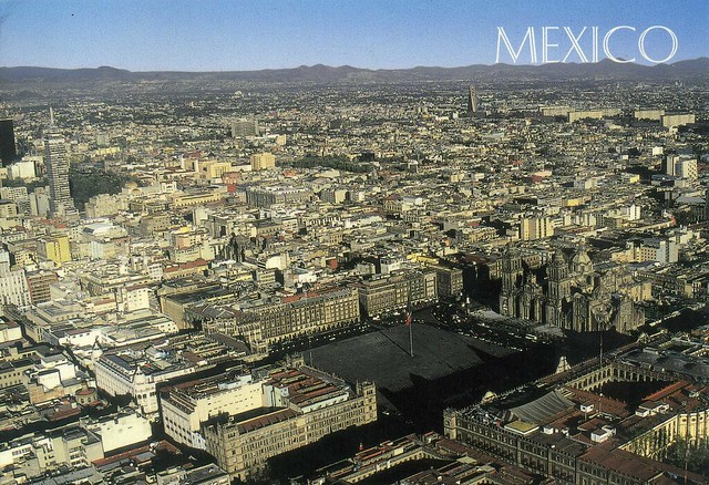
Mexico City, Mexico

I didn't mean to take this long to post about this card - I received it last September! Anyway, the lovely Ana surprised me with this great view of Mexico City from her holidays. :)


Mexico City, officially known as México, D. F., or simply D.F.) is the Federal District (Distrito Federal), capital of Mexico and seat of the federal powers of the Mexican Union. It is a federal entity within Mexico which is not part of any one of the 31 Mexican states but belongs to the federation as a whole. Mexico City is the country's largest city as well as its most important political, cultural, educational and financial center.

As an "alpha" global city Mexico City is one of the most important financial centers in North America. It is located in the Valley of Mexico (Valle de México), a large valley in the high plateaus at the center of Mexico, at an altitude of 2,240 metres. The city consists of sixteen boroughs.

The 2009 estimated population for the city proper was around 8.84 million people, and has a land area of 1,485 square kilometres. According to the most recent definition agreed upon by the federal and state governments, the Mexico City metropolitan area population is 21.2 million people, making it the largest metropolitan area in the western hemisphere, the fifth largest agglomeration and the largest Spanish-speaking city in the world.

The Greater Mexico City has a gross domestic product (GDP) of US$390 billion in 2008, making Mexico City urban agglomeration the eighth richest metropolitan area in the world. The city was responsible for generating 21% of Mexico's Gross Domestic Product and the metropolitan area accounted for 34% of total national GDP.

The city was originally built on an island of Lake Texcoco by the Aztecs in 1325 as Tenochtitlan, which was almost completely destroyed in the 1521 siege of Tenochtitlan, and subsequently redesigned and rebuilt in accordance with the Spanish urban standards. In 1524, the municipality of Mexico City was established, known as México Tenochtitlán, and as of 1585 it was officially known as Ciudad de México (Mexico City). Mexico City served as the political, administrative and financial center of a major part of the Spanish colonial empire. After independence from Spain was achieved, the Federal District was created in 1824.

The Historic Centre of Mexico City is also a Unesco World Heritage site. It has five Aztec temples, the ruins of which have been identified, a cathedral (the largest on the continent) and some fine 19th- and 20th-century public buildings such as the Palacio de las Bellas Artes.

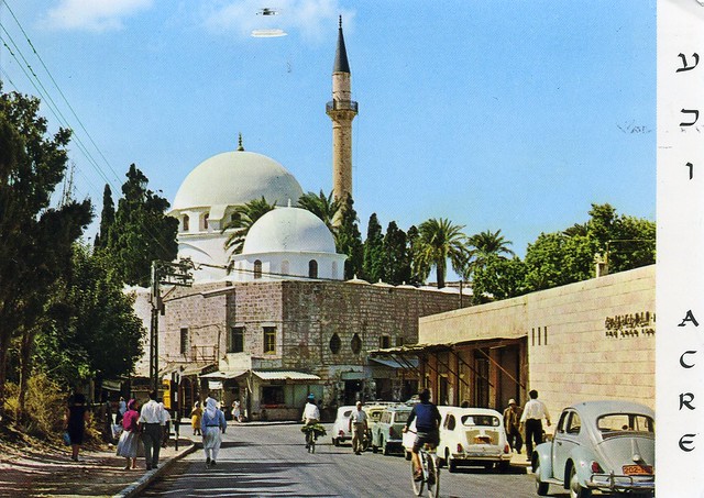
El Jazzar's Mosque, Acre, Israel

I haven't posted any Israeli postcards here for quite a while now so here's one, received back in 2009. ...and I just realised that this card probably counts towards my Unesco collection as well :)


Acre is a city in the Western Galilee region of northern Israel at the northern extremity of Haifa Bay. The city occupies an important location, as it sits on the coast of the Mediterranean, linking the waterways and commercial activity with the Levant Acre is one of the oldest continuously inhabited sites in the world.

Historically, it was a strategic coastal link to the Levant. In crusader times it was known as St. John d'Acre after the Knights Hospitaller of St John order who had their headquarters there. Acre is the holiest city of the Bahá'í Faith. In 2011, the population was 46,464. Acre is a mixed city, 72 percent Jewish and 28 percent Arab.

The Old City of Acre is a Unesco World Heritage site. Acre is a historic walled port-city with continuous settlement from the Phoenician period. The present city is characteristic of a fortified town dating from the Ottoman 18th and 19th centuries, with typical urban components such as the citadel, mosques, khans and baths. The remains of the Crusader town, dating from 1104 to 1291, lie almost intact, both above and below today's street level, providing an exceptional picture of the layout and structures of the capital of the medieval Crusader kingdom of Jerusalem.

Mariehamn, Åland

I have a few postcards sent from Åland now but up until now I didn't have any of Mariehamn, so when Suvi offered to send me a postcard from there, I just couldn't resist. Thank you so much, Suvi, it's always great to receive postcards from you!


Mariehamn (Finnish: Maarianhamina) is the capital of Åland, an autonomous territory under Finnish sovereignty. Mariehamn is the seat of the Government and Parliament of Åland, and 40% of the population of Åland live in the city. Like all of Åland, Mariehamn is unilingually Swedish-speaking and around 88% of the inhabitants speak it as their native language.

The town was named after Maria Alexandrovna, the Empress consort of Alexander II of Russia. Mariehamn was founded in 1861, around the village of Övernäs, in what was at the time part of the municipality of Jomala. The city has since expanded and incorporated more of Jomala territory. The city is located on a peninsula, and has two important harbours, one located on the western shore and one on the eastern shore. The Western Harbour is an important international harbour with daily traffic to Sweden and mainland Finland. A powerful incentive for Baltic ferries to stop at Mariehamn is that, with respect to indirect taxation, Åland is not part of the EU customs zone and so duty-free goods can be sold aboard. Mariehamn Airport is located in the neighbouring municipality of Jomala, some 3 kilometres north-west of Mariehamn city centre.

Åland and Mariehamn have a reputable heritage in shipping. The Flying P-Liner Pommern museum ship is anchored in the Western Harbour. The Eastern Harbour features one of the largest marinas in Scandinavia. The famous Dutch steamer Jan Nieveen (now called F.P. von Knorring, after Åland teacher and vicar Frans Peter von Knorring) can also be found here.

 The city is an important centre for Åland media; both of the local newspapers (Ålandstidningen and Nya Åland), several radio stations and the local TV channels (TV Åland and Åland24) operate out of the city.

Mariehamn features several buildings drawn by Finnish architect Lars Sonck, who moved to Åland as a child. Buildings drawn by him include the church of Mariehamn (1927), the main building of the Åland Maritime College (1927) and the town hall (1939). Hilda Hongell has also designed several buildings, although only a few are still standing.

Crown Mine, Botallack, England

My collection of UK Unesco sites is still fairly small... this official I received back in 2010 was a nice addition, and one of the more difficult sites to get over here I think.

 
GB-121492
 
Crown Mine in Botallack, Cornwall is part of the Cornwall and West Devon Mining Landscape. Botallack mine was first worked for its tin and copper in 1721, and for a long time was extremely profitable. Its galleries run beneath the sea for a third of a mile from the shore, and the deepest is 1,200 feet below high water. It is no longer worked.

Much of the landscape of Cornwall and West Devon was transformed in the 18th and early 19th centuries as a result of the rapid growth of pioneering copper and tin mining. Its deep underground mines, engine houses, foundries, new towns, smallholdings, ports and harbours, and their ancillary industries together reflect prolific innovation which, in the early 19th century, enabled the region to produce two-thirds of the world’s supply of copper. The substantial remains are a testimony to the contribution Cornwall and West Devon made to the Industrial Revolution in the rest of Britain and to the fundamental influence the area had on the mining world at large. Cornish technology embodied in engines, engine houses and mining equipment was exported around the world. Cornwall and West Devon were the heartland from which mining technology rapidly spread. (from the Unesco website)
 

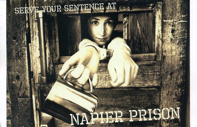
Napier Prison, New Zealand

This is definitely one of the more unusual postcards I've ever received from New Zealand!


Napier Prison is a former prison in Napier that was New Zealand's oldest prison. It closed in 1993 and is now an historic facility which offers guided tours twice daily and self-guided audio tours all-day, and also offers accommodation for backpackers. It is also the only building where it is possible to see the original path of the 1931 Hawke's Bay earthquake.

Napier Prison was constructed on Napier Hill in 1862 and was used until the early 1990s, being officially decommissioned in 1993. In addition to being a prison, the location was also used as an orphanage and a psychiatric unit. During the 19th century, five hangings were conducted at the prison.

There have been many reports of ghostly occurrences at the site such as unexplained footsteps,disembodied faces, doors opening and closing on their own, and the ghost of a murderer on the anniversary of his execution. The best known former prisoner is Roland Edwards, a mass murderer who reputedly has his spirit haunt the area. In 2011, a team from the television series Ghost Hunters International spent four days at the old prison and "were not disappointed".


I quite like the stamp in the bottom left corner - my middle name happens to be Elina! :D

Sunday, 7 July 2013

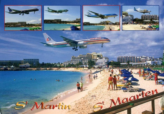
Saint Martin

One more post for today... which includes two postcards, the first one being from the swap with Addis in 2008, and the second one being from a swap earlier this year. I thought I'd stay in the same region... :P


Saint Martin (French: Saint-Martin; Dutch: Sint Maarten) is an island in the northeast Caribbean, approximately 300 km east of Puerto Rico. The 87 km2 island is divided roughly 60/40 between France (53 km2) and the Kingdom of the Netherlands (34 km2); they are roughly equal in population. It is one of the smallest sea islands divided between two nations, a division dating to 1648. The southern Dutch part comprises Sint Maarten and is one of four constituent countries that form the Kingdom of the Netherlands. The northern French part comprises the Collectivité de Saint-Martin (Collectivity of St. Martin) and is an overseas collectivity of France.

On January 1, 2009 the population of the entire island was 77,741 inhabitants, with 40,917 living on the Dutch side, and 36,824 on the French side.

Collectively, the two territories are known as "St-Martin / St Maarten". Sometimes SXM, the IATA identifier for Princess Juliana International Airport (the island's main airport), is used to refer to the island.


...and here's a view from Maho Bay, a plane landing at Princess Juliana airport, which serves the Dutch part of the island of Saint Martin. In 2007, the airport handled 1,647,824 passengers and 103,650 aircraft movements. The airport serves as a hub for Windward Islands Airways and is the major gateway for the smaller Leeward Islands, including Anguilla, Saba, St. Barthélemy and St. Eustatius. It is named after Juliana of the Netherlands, who as crown princess landed here in 1944, the year after the airport opened. There is also an airport on the French side of the island, called Aéroport de Grand Case or L'Espérance Airport. The airport is perhaps best known for very low-altitude flyover landing approaches due to one end of its runway being extremely close to the shore and Maho Beach.
This is the stamp on the second postcard, sadly not cancelled, but still mailed from Saint Martin. :)

San Juan, Puerto Rico

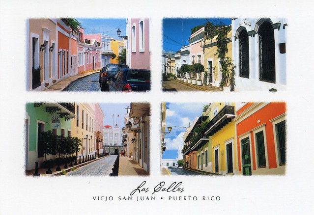
Postcards from another tropical paradise... this time Puerto Rico. These two cards are slightly older again, from a swap in 2008. I just love this map card, and San Juan looks really pretty as well!


Puerto Rico is an unincorporated territory of the United States, located in the northeastern Caribbean, east of the Dominican Republic and west of both the United States Virgin Islands and the British Virgin Islands. Puerto Rico (Spanish for "rich port") comprises an archipelago that includes the main island of Puerto Rico and a number of smaller islands, the largest of which are Vieques, Culebra, and Mona. The main island of Puerto Rico is the smallest by land area of the Greater Antilles. It ranks third in population among that group of four islands, which include Cuba, Hispaniola (Dominican Republic and Haiti), and Jamaica. Due to its location, Puerto Rico enjoys a tropical climate and is subject to the Atlantic hurricane season. Official languages of the island are Spanish and English, with Spanish being the primary language.


San Juan is the capital and most populous municipality in Puerto Rico, an unincorporated territory of the United States. As of the 2010 census, it had a population of 395,326 making it the 46th-largest city under the jurisdiction of the United States. San Juan was founded by Spanish colonists in 1521, who called it Ciudad de Puerto Rico ("Rich Port City"). Puerto Rico's capital is the second oldest European-established city in the Americas, after Santo Domingo, in the Dominican Republic. Several historical buildings are located in San Juan; among the most notable are the city's former defensive forts, Fort San Felipe del Morro and Fort San Cristóbal, and La Fortaleza, the oldest executive mansion in continuous use in the Americas.

"Old San Juan" is a tourist zone in the capital. Addis, who sent me this card, told me a bit about these streets:

- Calle San Sebastián has a festival every year organized by its residents.
- Calle Fortaleza leads you to the governor's palace (called 'La Fortaleza').
- Calle Cristo has lots of fancy shops.

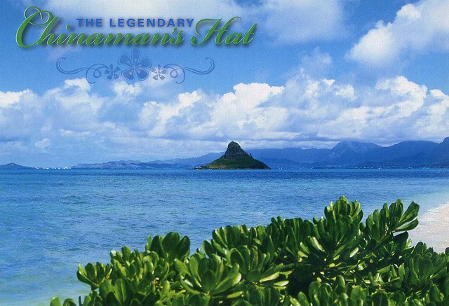
Chinaman's Hat, Hawaii, USA

This postcard is in the minority in my collection as it wasn't received through Postcrossing - and not even through Facebook! I've been in touch with Anne in Hawaii, swapping zines, stickers and tea, and once I asked her if she had any spare postcards she could send me (I don't have too many from Hawaii and it looks so beautiful there). She did ;) This is one of them, one of my favourites, although it was difficult to pick just one as they are all so beautiful.


Mokoliʻi is a 5.1 ha, 63 m tall basalt island 0.54 km offshore of Kualoa Point, Oahu, in Kāne'ohe Bay, Hawaii. Geologically, it used to be connected to Oahu before erosion cut it off. It is also known as "Chinaman's Hat" for its likeness to the straw hats Chinese immigrants wore. Wedge-tailed Shearwaters are the only species of bird that nests here; previously there were a few.

Mokoliʻi is open to the public from dawn to dusk. On weekends it is somewhat a popular secret with tourists and locals. It can be accessed by kayak, boat, surfboard, or by swimming; depth soundings are only four feet on its west side. This may be dangerous during any other time or inclement weather. The area is home to stonefish, and sharks are often seen around the island, often in early mornings.

Mauritius

This is one of the first postcards I've received through Postcrossing, way back in 2007 (has it really been that long?!), and certainly one of the very first private swap cards. Since then I haven't had too many other cards from Mauritius, either...


I don't have much to say about this card actually, there are no descriptions on the back of the card so I have no idea what these places are. I do really like it, though, and as I said, this card is kinda special to me as it's one of my first Postcrossing postcards. :)