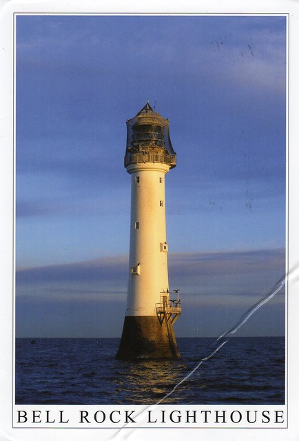
A lovely lighthouse postcard I received earlier this year through a Facebook swap. Iain kindly offered to send me a postcard with a new squirrel stamp. I can't get these Post & Go stamps anywhere near where I live, and the machines in the post office in Birmingham never have any of these nice pictorial stamps, they only ever seem to have the boring Queen's head ones. :( Thank you, Iain! It's just annoying that the postcard took a bit of a battering on its way down to England from Scotland.
The Bell Rock Lighthouse, off the coast of Angus, Scotland, is the world's oldest surviving sea-washed lighthouse. It was built between 1807 and 1810 by Robert Stevenson on the Bell Rock (also known as Inchcape) in the North Sea, 18 km east of the Firth of Tay. Standing 35 metres tall, its light is visible from 56 km inland.
The masonry work on which the lighthouse rests was constructed to such a high standard that it has not been replaced or adapted in 200 years. The lamps and reflectors were replaced in 1843 and used in the lighthouse at Cape Bonavista, Newfoundland, where they are currently on display. The working of the lighthouse has been automated since 1988.
The lighthouse operated in tandem with a shore station, the Bell Rock Signal Tower, built in 1813 at the mouth of Arbroath harbour. Today this building houses the Signal Tower Museum, a visitor centre detailing the history of the lighthouse.
The challenges faced in the building of the lighthouse have led to it being described as one of the Seven Wonders of the Industrial World.
Showing posts with label scotland. Show all posts
Tuesday, 2 February 2016
Sunday, 6 September 2015
John o'Groats, Scotland
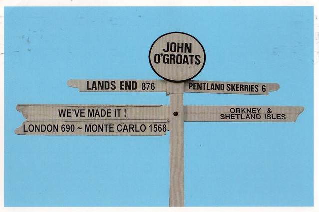
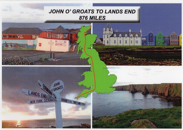
Just a small post for today as I want to go to bed early. I'll start off with this card I received from Matt's parents last month from their holiday. They went to northern Scotland for two weeks and also visited John o'Groats.
John o' Groats (Gaelic: Taigh Iain Ghròt) is a village in the Canisby parish of Caithness, in the far north of Scotland. John o' Groats lies on Britain's northeastern tip, and is popular with tourists as one end of the longest distance between two inhabited British points, with Land's End in Cornwall lying 876 miles to the southwest. It is not quite the most northerly point on the island of Britain; nearby Dunnet Head is further north.
John o' Groats is 1,110 km from London, 450 km from Edinburgh, 9.7 km from the Orkney Isles and 3,500 km from the North Pole. It is 6.84 km from the uninhabited island of Stroma. A passenger ferry operates from John o' Groats to Burwick on South Ronaldsay in Orkney.
Matt's parents also gave me a bunch of postcards when they got back home. This is one of them and possibly my favourite:
Matt's dad told me the postcard was supposed to be cancelled with a John o'Groats cancellation. I first thought I didn't get the cancellation, but I think it is there, you can just about see it as it's very faint.
John o' Groats (Gaelic: Taigh Iain Ghròt) is a village in the Canisby parish of Caithness, in the far north of Scotland. John o' Groats lies on Britain's northeastern tip, and is popular with tourists as one end of the longest distance between two inhabited British points, with Land's End in Cornwall lying 876 miles to the southwest. It is not quite the most northerly point on the island of Britain; nearby Dunnet Head is further north.
John o' Groats is 1,110 km from London, 450 km from Edinburgh, 9.7 km from the Orkney Isles and 3,500 km from the North Pole. It is 6.84 km from the uninhabited island of Stroma. A passenger ferry operates from John o' Groats to Burwick on South Ronaldsay in Orkney.
Matt's parents also gave me a bunch of postcards when they got back home. This is one of them and possibly my favourite:
Matt's dad told me the postcard was supposed to be cancelled with a John o'Groats cancellation. I first thought I didn't get the cancellation, but I think it is there, you can just about see it as it's very faint.
Friday, 10 January 2014
Carraig Fhada Lighthouse, Islay, Scotland
Another postcard I received last year, this one is from my Finnish penpal Keiju, sent from her holidays in Scotland. She got to visit some amazing places - how lovely would it be to visit some of these more remote parts of Scotland?!?
Carraig Fhada Lighthouse is located at Port Ellen, a small town on the island of Islay, in Argyll, Scotland. Islay, then, is the southernmost island of the Inner Hebrides of Scotland. Known as "The Queen of the Hebrides", it lies in Argyll just south west of Jura and around 40 kilometres north of the Irish coast. The island's capital and largest settlement is Bowmore where the distinctive round Kilarrow Parish Church and a distillery are located. Port Ellen is the main port.
Islay is the fifth-largest Scottish island and the seventh-largest island surrounding Great Britain, with a total area of almost 620 square kilometres. There is ample evidence of the prehistoric settlement of Islay and the first written reference may have come in the 1st century AD. The island had become part of the Gaelic Kingdom of Dál Riata during the Early Middle Ages before being absorbed into the Norse Kingdom of the Isles. The later medieval period marked a "cultural high point" with the transfer of the Hebrides to the Kingdom of Scotland and the emergence of the Clan Donald Lordship of the Isles, originally centred at Finlaggan. During the 17th century the Clan Donald star waned, but improvements to agriculture and transport led to a rising population, which peaked in the mid-19th century. This was followed by substantial forced displacements and declining resident numbers.
Today, it has over 3,000 inhabitants and the main commercial activities are agriculture, malt whisky distillation and tourism. The island has a long history of religious observance and Scottish Gaelic is spoken by about a quarter of the population. Its landscapes have been celebrated through various art forms and there is a growing interest in renewable energy. Islay is home to many bird species such as the wintering populations of Greenland White-fronted and Barnacle Goose, and is a popular destination throughout the year for birdwatchers. The climate is mild and ameliorated by the Gulf Stream.
I have to confess I pretty much only recognised the name 'Islay' before because of whisky - my dad really likes whisky and I recognise some of the names on the bottles (Laphroaig and Ardbeg mostly). Islay is one of five whisky distilling localities and regions in Scotland whose identity is protected by law. There are eight active distilleries and the industry is the island's second largest employer after agriculture. Those on the south of the island produce malts with a very strong peaty flavour, considered to be the most intensely flavoured of all whiskies. From east to west they are Ardbeg, Lagavulin, and Laphroaig. On the north of the island Bowmore, Bruichladdich, Caol Ila and Bunnahabhain are produced, which are substantially lighter in taste. Kilchoman is a microdistillery opened in 2005 toward the west coast of the Rinns. The oldest record of a legal distillery on the island refers to Bowmore in 1779 and at one time there were up to 23 distilleries in operation.
You don't need to pay this much to send a postcard within the UK... I'm guessing Keiju didn't realise this, I just feel bad that she ended up overpaying to send my card.
Carraig Fhada Lighthouse is located at Port Ellen, a small town on the island of Islay, in Argyll, Scotland. Islay, then, is the southernmost island of the Inner Hebrides of Scotland. Known as "The Queen of the Hebrides", it lies in Argyll just south west of Jura and around 40 kilometres north of the Irish coast. The island's capital and largest settlement is Bowmore where the distinctive round Kilarrow Parish Church and a distillery are located. Port Ellen is the main port.
Islay is the fifth-largest Scottish island and the seventh-largest island surrounding Great Britain, with a total area of almost 620 square kilometres. There is ample evidence of the prehistoric settlement of Islay and the first written reference may have come in the 1st century AD. The island had become part of the Gaelic Kingdom of Dál Riata during the Early Middle Ages before being absorbed into the Norse Kingdom of the Isles. The later medieval period marked a "cultural high point" with the transfer of the Hebrides to the Kingdom of Scotland and the emergence of the Clan Donald Lordship of the Isles, originally centred at Finlaggan. During the 17th century the Clan Donald star waned, but improvements to agriculture and transport led to a rising population, which peaked in the mid-19th century. This was followed by substantial forced displacements and declining resident numbers.
Today, it has over 3,000 inhabitants and the main commercial activities are agriculture, malt whisky distillation and tourism. The island has a long history of religious observance and Scottish Gaelic is spoken by about a quarter of the population. Its landscapes have been celebrated through various art forms and there is a growing interest in renewable energy. Islay is home to many bird species such as the wintering populations of Greenland White-fronted and Barnacle Goose, and is a popular destination throughout the year for birdwatchers. The climate is mild and ameliorated by the Gulf Stream.
I have to confess I pretty much only recognised the name 'Islay' before because of whisky - my dad really likes whisky and I recognise some of the names on the bottles (Laphroaig and Ardbeg mostly). Islay is one of five whisky distilling localities and regions in Scotland whose identity is protected by law. There are eight active distilleries and the industry is the island's second largest employer after agriculture. Those on the south of the island produce malts with a very strong peaty flavour, considered to be the most intensely flavoured of all whiskies. From east to west they are Ardbeg, Lagavulin, and Laphroaig. On the north of the island Bowmore, Bruichladdich, Caol Ila and Bunnahabhain are produced, which are substantially lighter in taste. Kilchoman is a microdistillery opened in 2005 toward the west coast of the Rinns. The oldest record of a legal distillery on the island refers to Bowmore in 1779 and at one time there were up to 23 distilleries in operation.
You don't need to pay this much to send a postcard within the UK... I'm guessing Keiju didn't realise this, I just feel bad that she ended up overpaying to send my card.
Thursday, 15 September 2011
Glenfinnan Viaduct, Scotland
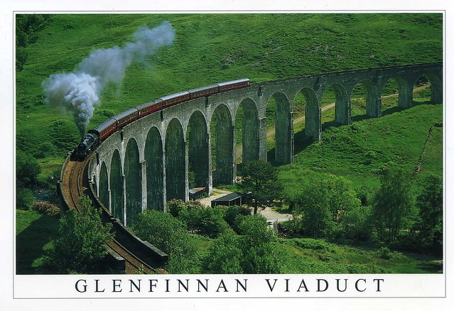
The last month and a half have been really hectic and so much has happened (not all very good, either.. :/) so I'm behind with a lot of things and not just this blog. I thought I'd post one more card today just to try and get back to the habit of updating this blog and maybe do that a bit more often again.. This one is holiday-themed as well - it's from Matt's older sister Rachel, sent during her holiday to Scotland last month. She spent a few days in Edinburgh and a while in the Highlands as well, which I'm perhaps even more jealous of. I'd love to visit the Scottish Highlands one day, too, and I certainly wouldn't mind travelling on 'Hogwarts Express'!

Glenfinnan Viaduct is a railway viaduct on the West Highland Line in Glenfinnan, Lochaber, Highland, Scotland. It was built between 1897 and 1901. Located at the top of Loch Shiel in the West Highlands of Scotland, the viaduct overlooks the Glenfinnan Monument and the waters of Loch Shiel.
The West Highland Line connects Fort William and Mallaig, and was a crucial vein for the local fishing industry and the highlands economy in general, which suffered enormously after the Highland Clearances of the 1800s.
The line is used by passenger trains operated by ScotRail between Glasgow Queen Street and Mallaig, usually diesel multiple units. Additionally in the summer the heritage Jacobite steam train operates along the line. It is a popular tourist event in the area, and the viaduct is one of the major attractions of the line. It is also the 'Harry Potter Express' - as Rachel put it :) She actually saw it pass by one of the B&B's she was staying in!

One of the most common stamps I see on my mail... It looks like this one's not very new, though, as it doesn't have any of the more recent security features on it.
Glenfinnan Viaduct is a railway viaduct on the West Highland Line in Glenfinnan, Lochaber, Highland, Scotland. It was built between 1897 and 1901. Located at the top of Loch Shiel in the West Highlands of Scotland, the viaduct overlooks the Glenfinnan Monument and the waters of Loch Shiel.
The West Highland Line connects Fort William and Mallaig, and was a crucial vein for the local fishing industry and the highlands economy in general, which suffered enormously after the Highland Clearances of the 1800s.
The line is used by passenger trains operated by ScotRail between Glasgow Queen Street and Mallaig, usually diesel multiple units. Additionally in the summer the heritage Jacobite steam train operates along the line. It is a popular tourist event in the area, and the viaduct is one of the major attractions of the line. It is also the 'Harry Potter Express' - as Rachel put it :) She actually saw it pass by one of the B&B's she was staying in!

One of the most common stamps I see on my mail... It looks like this one's not very new, though, as it doesn't have any of the more recent security features on it.
Wednesday, 15 September 2010
Barra, Outer Hebrides, Scotland
...and here's the final Scotland postcard from Andy. This one shows Barra on the Outer Hebrides.

Kisimul Castle dominates Castlebay, the main settlement of Barra. The most southerly of the Outer Hebrides, Barra is a very attractive island which has been aptly described as the "Hebrides in Miniature". The vessel MV "Lord of the Isles" provides the daily ro-ro link with Oban.
The 2001 census showed that the resident population was 1,078. The area of Barra is roughly 60 square kilometres, the main village being Castlebay (Bàgh a' Chaisteil). Barra is now linked by a man-made causeway to the neighbouring island of Vatersay (Eilean Bhatarsaigh). The Isle of Barra is a predominantly Gaelic-speaking island.
The west of the island has white sandy beaches backed by shell-sand machair and the east has numerous rocky inlets. Barra is abundant with stunning scenery, rare flowers and wildlife, which can be appreciated by coastal or hill walks, drives or cycle rides along the various small roads. Car and bicycle hire are available locally.
Uniquely in Europe, Barra's tiny airport, near Northbay, uses the beach called An Tràigh Mhòr (English: The Big Beach) as a runway. Planes can only land and take off at low tide meaning that the timetable varies. Barra's airport is the only airport in the world to have scheduled flights landing on a beach. The aircraft currently in operation on Barra is the de Havilland Canada DHC-6 Twin Otter, flown by Loganair on services to Glasgow and Benbecula from where connections to Stornoway are also available. There are no flights on Sundays.
Kisimul Castle dominates Castlebay, the main settlement of Barra. The most southerly of the Outer Hebrides, Barra is a very attractive island which has been aptly described as the "Hebrides in Miniature". The vessel MV "Lord of the Isles" provides the daily ro-ro link with Oban.
The 2001 census showed that the resident population was 1,078. The area of Barra is roughly 60 square kilometres, the main village being Castlebay (Bàgh a' Chaisteil). Barra is now linked by a man-made causeway to the neighbouring island of Vatersay (Eilean Bhatarsaigh). The Isle of Barra is a predominantly Gaelic-speaking island.
The west of the island has white sandy beaches backed by shell-sand machair and the east has numerous rocky inlets. Barra is abundant with stunning scenery, rare flowers and wildlife, which can be appreciated by coastal or hill walks, drives or cycle rides along the various small roads. Car and bicycle hire are available locally.
Uniquely in Europe, Barra's tiny airport, near Northbay, uses the beach called An Tràigh Mhòr (English: The Big Beach) as a runway. Planes can only land and take off at low tide meaning that the timetable varies. Barra's airport is the only airport in the world to have scheduled flights landing on a beach. The aircraft currently in operation on Barra is the de Havilland Canada DHC-6 Twin Otter, flown by Loganair on services to Glasgow and Benbecula from where connections to Stornoway are also available. There are no flights on Sundays.
Shetland, Scotland
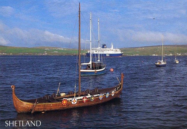
Ok, while we're so high up in the north of Scotland, I thought I'd also post about Shetland since one of the cards Andy sent me is from there. I've become more interested in Shetland in the last few months, mainly thanks to Simon King's book "The Shetland Diaries". The descriptions of the wilderness and natural beauty of these remote islands are truly fascinating. Shetland is so far from everywhere and it sounds like something out of this world.

Shetland is an archipelago in Scotland, off the northeast coast. The islands lie to the northeast of Orkney, 280 km from the Faroe Islands and form part of the division between the Atlantic Ocean to the west and the North Sea to the east. The total area is approximately 1,466 km2. Administratively, the area is one of the 32 council areas of Scotland for which the now-archaic spelling Zetland was used until 1970. The islands' administrative centre and only burgh is Lerwick.
The largest island, known as the "Mainland", has an area of 967 km2, making it the third-largest Scottish island and the fifth-largest of the British Isles.
Out of the approximately 100 islands, only 15 are inhabited. The main island of the group is known as Mainland. The other inhabited islands are: Bressay, Burra, Fetlar, Muckle Roe, Papa Stour, Trondra, Vaila, Unst, Whalsay, Yell in the main Shetland group, plus Foula to the south-west, Fair Isle to the south, and Housay and Bruray in the Out Skerries to the east.
On this postcard you can see P&O ferry St Clair leaving Lerwick. P&O Scottish Ferries operate regular ro-ro sailings to Aberdeen and Stromness from Lerwick. Replica longship Dim Riv in foreground, Bressau in background. St Clair operates to Aberdeen and to Bergen in summer.
Shetland is an archipelago in Scotland, off the northeast coast. The islands lie to the northeast of Orkney, 280 km from the Faroe Islands and form part of the division between the Atlantic Ocean to the west and the North Sea to the east. The total area is approximately 1,466 km2. Administratively, the area is one of the 32 council areas of Scotland for which the now-archaic spelling Zetland was used until 1970. The islands' administrative centre and only burgh is Lerwick.
The largest island, known as the "Mainland", has an area of 967 km2, making it the third-largest Scottish island and the fifth-largest of the British Isles.
Out of the approximately 100 islands, only 15 are inhabited. The main island of the group is known as Mainland. The other inhabited islands are: Bressay, Burra, Fetlar, Muckle Roe, Papa Stour, Trondra, Vaila, Unst, Whalsay, Yell in the main Shetland group, plus Foula to the south-west, Fair Isle to the south, and Housay and Bruray in the Out Skerries to the east.
On this postcard you can see P&O ferry St Clair leaving Lerwick. P&O Scottish Ferries operate regular ro-ro sailings to Aberdeen and Stromness from Lerwick. Replica longship Dim Riv in foreground, Bressau in background. St Clair operates to Aberdeen and to Bergen in summer.
Italian Chapel, Lamb Holm, Orkney Islands, Scotland
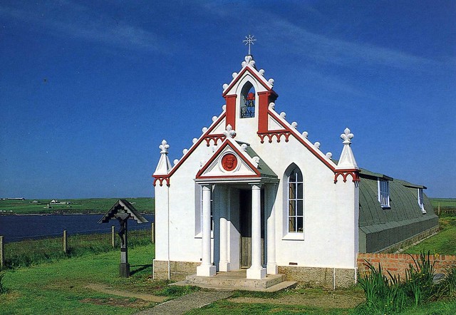
One more postcard from the Orkney Islands. I just HAD to post this, isn't it a cute little chapel?!

Built during World War 2 by Italian prisoners of war engaged in building the Churchill Barriers, this beautiful little chapel is all that remains of camp 60. Constructed from two Nissen huts, the chapel is situated on the Holm side of Lamb Holm. Lamb Holm is a small uninhabited island in Orkney, and the highly ornate Italian Chapel is the island's main attraction.
Stromness, Orkney Islands, Scotland
Another card from the Orkney Islands...

Stromness is the second-largest town in Orkney after Kirkwall, and is located in the south-west of Mainland in Orkney.
The name "Stromness" is derived from the Norse language. "Strom" refers to the strong tides that rip past the Point of Ness to the south of the town. "Ness" means "headland". Stromness literally means "current headland". In Viking times Stromness was called Hamnavoe, meaning "peaceful" or "safe harbour".
A long-established seaport, it has a population of approximately 2,190 residents. The old town is clustered along the characterful and winding main street, flanked with houses and shops built from local stone, with narrow lanes and alleys branching off it. There is a ferry link from Stromness to Scrabster on the north coast of mainland Scotland.
First recorded as the site of an inn in the 16th century, Stromness became important during the late 17th century, when England was at war with France and shipping was forced to avoid the English Channel. Ships of the Hudson's Bay Company were regular visitors, as were whaling fleets. Large numbers of Orkneymen, notably from Stromness, served as traders, explorers and seamen for both. Stromness Museum reflects these aspects of the town's history (displaying for example important collections of whaling relics, and Inuit artefacts brought back as souvenirs by local men from Greenland and Arctic Canada). An unusual aspect of the town's character is the large number of buildings decorated with displays of whale bones outside them.
Stromness is the second-largest town in Orkney after Kirkwall, and is located in the south-west of Mainland in Orkney.
The name "Stromness" is derived from the Norse language. "Strom" refers to the strong tides that rip past the Point of Ness to the south of the town. "Ness" means "headland". Stromness literally means "current headland". In Viking times Stromness was called Hamnavoe, meaning "peaceful" or "safe harbour".
A long-established seaport, it has a population of approximately 2,190 residents. The old town is clustered along the characterful and winding main street, flanked with houses and shops built from local stone, with narrow lanes and alleys branching off it. There is a ferry link from Stromness to Scrabster on the north coast of mainland Scotland.
First recorded as the site of an inn in the 16th century, Stromness became important during the late 17th century, when England was at war with France and shipping was forced to avoid the English Channel. Ships of the Hudson's Bay Company were regular visitors, as were whaling fleets. Large numbers of Orkneymen, notably from Stromness, served as traders, explorers and seamen for both. Stromness Museum reflects these aspects of the town's history (displaying for example important collections of whaling relics, and Inuit artefacts brought back as souvenirs by local men from Greenland and Arctic Canada). An unusual aspect of the town's character is the large number of buildings decorated with displays of whale bones outside them.
Orkney Islands, Scotland
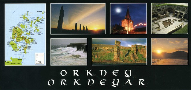
Let's stay on islands. I received this card, and a bunch of other lovely postcards of Scotland from the lovely Andy from postcrossing before I went to Finland and have been meaning to post about this and a few others ever since. This is one of my favourites, probably because it includes a map and it's a panoramic postcard (I'm quite fond of panoramic postcards).

There was some helpful info on the back of the card:
The seventy-plus Orkney Islands lie at latitude of 59°N, with an area of 9700ha a coastline of 920km, and a population of about 21,000. Only 10km at closest from Scotland, Orkney's diverse economy comprises agriculture, fishing, tourism, crafts, whisky and oil. The mild climate is due to the North Atlantic Slope Current and weather systems. There is much to see and do including world class archaelogy, magnificent coastal scenery, wildlife, as well as such things as the Churchill Barries, Old Man of Hoy and St Magnus Cathedral.
There was some helpful info on the back of the card:
The seventy-plus Orkney Islands lie at latitude of 59°N, with an area of 9700ha a coastline of 920km, and a population of about 21,000. Only 10km at closest from Scotland, Orkney's diverse economy comprises agriculture, fishing, tourism, crafts, whisky and oil. The mild climate is due to the North Atlantic Slope Current and weather systems. There is much to see and do including world class archaelogy, magnificent coastal scenery, wildlife, as well as such things as the Churchill Barries, Old Man of Hoy and St Magnus Cathedral.
Monday, 5 July 2010
Glasgow, Scotland
Another official card, this one arrived today, up from Scotland.

GB-150059
I'm not a huge fan of UK multiview postcards in general, but this one is more special as it's from Glasgow. I really love Scotland; for some reason I always feel right at home there, it would be great to live there one day, but I might just keep on dreaming... I've been to Glasgow once (almost five years ago now... too long!). A very good friend of mine lives there and I went to visit her when I was studying in England. I really liked the city and would love to go there again. I really should, I want to meet up with my friend again!
My clearest memories relate to visiting the grounds of the Glasgow University (it looks like Hogwarts! :D), wandering around in the Bothanic Garden, and a visit to Uisge Beatha, where all the waiters wore kilts. Mmmmmmm...! ;)
Anyway. This postcard shows (from top left corner:) Art Galleries and Museum; St. Enoch's Square; The River Clyde; and Art Gallery from the River Kelvin.

The stamp is the Scottish second class definitive stamp, showing the Scottish flag (obviously :P).
I'm not a huge fan of UK multiview postcards in general, but this one is more special as it's from Glasgow. I really love Scotland; for some reason I always feel right at home there, it would be great to live there one day, but I might just keep on dreaming... I've been to Glasgow once (almost five years ago now... too long!). A very good friend of mine lives there and I went to visit her when I was studying in England. I really liked the city and would love to go there again. I really should, I want to meet up with my friend again!
My clearest memories relate to visiting the grounds of the Glasgow University (it looks like Hogwarts! :D), wandering around in the Bothanic Garden, and a visit to Uisge Beatha, where all the waiters wore kilts. Mmmmmmm...! ;)
Anyway. This postcard shows (from top left corner:) Art Galleries and Museum; St. Enoch's Square; The River Clyde; and Art Gallery from the River Kelvin.

The stamp is the Scottish second class definitive stamp, showing the Scottish flag (obviously :P).
Tuesday, 15 June 2010
North Uist, Scotland
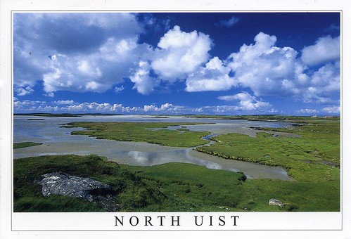
Another card from the Western Islands in Scotland and also from Sarah (who doesn't seem to be active on postcrossing anymore :( ). I received this one last year as well, but it's such a lovely card that it definitely deserves a spot here. :)

This card shows Vallay Strand in North Uist. Uist (or The Uists) are the central group of islands in the Outer Hebrides of Scotland. The Outer Hebrides is a chain of more than 100 islands and small skerries located about 70 kilometres west of mainland Scotland. There are 15 inhabited islands in this archipelago, which is also known as the Western Isles and archaically as the Long Isle.
Lewis and Harris is the largest island in Scotland and the third largest in the British Isles, after Great Britain and Ireland. It incorporates Lewis in the north and Harris in the south, both of which are frequently referred to as individual islands, although they are joined by a land border. The largest settlement in Lewis and in the Outer Hebrides is Stornoway.
The Outer Hebrides had a population of 26,502 in 2001. The area has historically been a strong Scottish Gaelic (Gàidhlig) speaking area. Despite recent declines, in the 2001 census more than 50% of the resident population in each island was able to speak Gaelic, for an overall total of 15,842 speakers throughout the archipelago. The modern economy centres on tourism, crofting, fishing, and weaving, the latter of which includes the manufacture of Harris tweed. The archipelago is exposed to wind and tide, and there are numerous lighthouses as an aid to navigation.
This card shows Vallay Strand in North Uist. Uist (or The Uists) are the central group of islands in the Outer Hebrides of Scotland. The Outer Hebrides is a chain of more than 100 islands and small skerries located about 70 kilometres west of mainland Scotland. There are 15 inhabited islands in this archipelago, which is also known as the Western Isles and archaically as the Long Isle.
Lewis and Harris is the largest island in Scotland and the third largest in the British Isles, after Great Britain and Ireland. It incorporates Lewis in the north and Harris in the south, both of which are frequently referred to as individual islands, although they are joined by a land border. The largest settlement in Lewis and in the Outer Hebrides is Stornoway.
The Outer Hebrides had a population of 26,502 in 2001. The area has historically been a strong Scottish Gaelic (Gàidhlig) speaking area. Despite recent declines, in the 2001 census more than 50% of the resident population in each island was able to speak Gaelic, for an overall total of 15,842 speakers throughout the archipelago. The modern economy centres on tourism, crofting, fishing, and weaving, the latter of which includes the manufacture of Harris tweed. The archipelago is exposed to wind and tide, and there are numerous lighthouses as an aid to navigation.
Labels:
2009,
outer hebrides,
scotland,
tags,
uist,
western isles
Monday, 14 June 2010
St Kilda, Scotland
I thought I'd throw in a random card as I'm currently transferring (a ton of) photos from my laptop to an external harddrive, and it's taking ages. :S I received this card last year and it's still one of my favourites. It's very beautiful, AND it's from Scotland and a Unesco site as well.

This volcanic archipelago, with its spectacular landscapes, is situated off the coast of the Hebrides and comprises the islands of Hirta, Dun, Soay and Boreray. It has some of the highest cliffs in Europe, which have large colonies of rare and endangered species of birds, especially puffins and gannets. The archipelago, uninhabited since 1930, bears the evidence of more than 2,000 years of human occupation in the extreme conditions prevalent in the Hebrides. Human vestiges include built structures and field systems, the cleits and the traditional Highland stone houses. They feature the vulnerable remains of a subsistence economy based on the products of birds, agriculture and sheep farming.
You can read more about St Kilda here. Sarah, who sent me this card, told me that she can see this place on the horizon from her village!

The stamp is from a set of 6 stamps representing Cathedrals, issued in 2008. This one shows the Lichfield Cathedral.
This volcanic archipelago, with its spectacular landscapes, is situated off the coast of the Hebrides and comprises the islands of Hirta, Dun, Soay and Boreray. It has some of the highest cliffs in Europe, which have large colonies of rare and endangered species of birds, especially puffins and gannets. The archipelago, uninhabited since 1930, bears the evidence of more than 2,000 years of human occupation in the extreme conditions prevalent in the Hebrides. Human vestiges include built structures and field systems, the cleits and the traditional Highland stone houses. They feature the vulnerable remains of a subsistence economy based on the products of birds, agriculture and sheep farming.
You can read more about St Kilda here. Sarah, who sent me this card, told me that she can see this place on the horizon from her village!

The stamp is from a set of 6 stamps representing Cathedrals, issued in 2008. This one shows the Lichfield Cathedral.
Labels:
2009,
outer hebrides,
RR,
scotland,
st kilda,
unesco,
western isles
Friday, 4 June 2010
Oban, Scotland
Another card from a friend... I received this one from Seonad, a lovely person I know from livejournal. She lives in Perth, Scotland, but visited Oban a few years ago, and sent me a postcard from her trip. :)

Card scenes: Right: The Town and Harbour. Top left: The Harbour. Bottom left: Oban from McCaig's Folly.
Oban is a resort town within the Argyll and Bute council area of Scotland. It has a total resident population of 8,120. Despite its small size, it is the largest town between Helensburgh and Fort William and during the tourist season the town can be crowded by up to 25,000 people. Oban occupies a beautiful setting in the Firth of Lorn. Oban Bay is a near perfect horseshoe bay, protected by the island of Kerrera, and beyond Kerrera is Mull. To the north is the long low island of Lismore, and the mountains of Morvern and Ardgour.
In Oban "The Gateway to the Isles" some 9.4% of the population speak Gaelic.
Attractions in Oban include the Waterfront Centre, the Cathedral of St Columba, the Oban Distillery, Dunollie Castle, Dunstaffnage Castle and McCaig's Tower, which dominates the town's skyline. [from Wikipedia]
Card scenes: Right: The Town and Harbour. Top left: The Harbour. Bottom left: Oban from McCaig's Folly.
Oban is a resort town within the Argyll and Bute council area of Scotland. It has a total resident population of 8,120. Despite its small size, it is the largest town between Helensburgh and Fort William and during the tourist season the town can be crowded by up to 25,000 people. Oban occupies a beautiful setting in the Firth of Lorn. Oban Bay is a near perfect horseshoe bay, protected by the island of Kerrera, and beyond Kerrera is Mull. To the north is the long low island of Lismore, and the mountains of Morvern and Ardgour.
In Oban "The Gateway to the Isles" some 9.4% of the population speak Gaelic.
Attractions in Oban include the Waterfront Centre, the Cathedral of St Columba, the Oban Distillery, Dunollie Castle, Dunstaffnage Castle and McCaig's Tower, which dominates the town's skyline. [from Wikipedia]
Subscribe to:
Posts (Atom)


Maroon