A lovely springtime view from the USA I received last year from a Year of the Horse stamp swap. Just look at the colours here!
Napa Valley AVA is an American Viticultural Area located in Napa County, California, United States. Napa Valley is considered one of the premier wine regions in the world. Records of commercial wine production in the region date back to the nineteenth century, but premium wine production dates back only to the 1960s.
The combination of Mediterranean climate, geography and geology of the region are conducive to growing quality wine grapes. John Patchett established the Napa Valley's first commercial vineyard in 1858. In 1861 Charles Krug established another of Napa Valley's first commercial wineries in St. Helena. Viticulture in Napa suffered several setbacks in the late 19th and early 20th centuries, including an outbreak of the vine disease phylloxera, the institution of Prohibition, and the Great Depression. The wine industry in Napa Valley recovered, and helped by the results of the Paris Wine Tasting of 1976, came to be seen as capable of producing the best quality wine – equal to that of Old World wine regions. Napa Valley is now a major enotourism destination.
Showing posts with label year of the horse. Show all posts
Wednesday, 22 April 2015
Wednesday, 15 April 2015
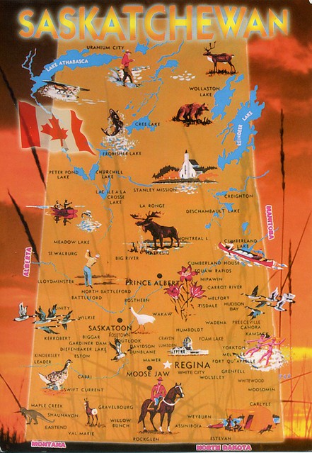
Saskatchewan, Canada
Another Lunar Year swap card, this time from Canada. This was officially a Year of the Horse swap, but the sender, Deanna, used older Lunar Year stamps as well. ...and managed to get me a wonderful special cancellation from Love! :)
Saskatchewan is a prairie province in Canada, which has a total area of 651,900 square kilometres and a land area of 592,534 square kilometres, the remainder being water area (covered by lakes/ponds, reservoirs and rivers). Saskatchewan is bordered on the west by the Province of Alberta, on the north by the Northwest Territories, on the east by Manitoba, and on the south by the U.S. states of Montana and North Dakota. As of December 2013, the population of Saskatchewan was estimated at 1,114,170. Residents primarily live in the southern half of the province. Of the total population, 257,300 live in the province's largest city, Saskatoon, while 210,000 live in the provincial capital, Regina. Other major cities include Prince Albert, Moose Jaw, Yorkton, Swift Current, and North Battleford.
Saskatchewan has been inhabited for thousands of years by various indigenous groups, and first explored by Europeans in 1690 and settled in 1774. It became a province in 1905, its name derived from the Saskatchewan River. The river was known as kisiskāciwani-sīpiy ("swift flowing river") in the Cree language. In the early 20th century the province became known as a stronghold for Canadian democratic socialism. Tommy Douglas, who was premier from 1944 to 1961, became the first social-democratic politician to be elected in North America. The province's economy is based on agriculture, mining, and energy. Saskatchewan's current premier is Brad Wall and its lieutenant-governor is Vaughn Solomon Schofield.
In 1992, the federal and provincial governments signed a historic land claim agreement with Saskatchewan First Nations. The First Nations received compensation and were permitted to buy land on the open market for the tribes; they have acquired about 761,000 acres, now reserve lands. Some First Nations have used their settlement to invest in urban areas, including Saskatoon.
Saskatchewan is a prairie province in Canada, which has a total area of 651,900 square kilometres and a land area of 592,534 square kilometres, the remainder being water area (covered by lakes/ponds, reservoirs and rivers). Saskatchewan is bordered on the west by the Province of Alberta, on the north by the Northwest Territories, on the east by Manitoba, and on the south by the U.S. states of Montana and North Dakota. As of December 2013, the population of Saskatchewan was estimated at 1,114,170. Residents primarily live in the southern half of the province. Of the total population, 257,300 live in the province's largest city, Saskatoon, while 210,000 live in the provincial capital, Regina. Other major cities include Prince Albert, Moose Jaw, Yorkton, Swift Current, and North Battleford.
Saskatchewan has been inhabited for thousands of years by various indigenous groups, and first explored by Europeans in 1690 and settled in 1774. It became a province in 1905, its name derived from the Saskatchewan River. The river was known as kisiskāciwani-sīpiy ("swift flowing river") in the Cree language. In the early 20th century the province became known as a stronghold for Canadian democratic socialism. Tommy Douglas, who was premier from 1944 to 1961, became the first social-democratic politician to be elected in North America. The province's economy is based on agriculture, mining, and energy. Saskatchewan's current premier is Brad Wall and its lieutenant-governor is Vaughn Solomon Schofield.
In 1992, the federal and provincial governments signed a historic land claim agreement with Saskatchewan First Nations. The First Nations received compensation and were permitted to buy land on the open market for the tribes; they have acquired about 761,000 acres, now reserve lands. Some First Nations have used their settlement to invest in urban areas, including Saskatoon.
Labels:
2014,
canada,
saskatchewan,
swap,
year of the dragon,
year of the horse,
year of the snake
Sunday, 5 April 2015
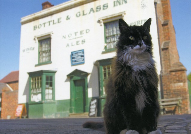
Sylvester at the Bottle and Gas, Black Country Living Museum, Dudley, England
A postcard I sent to myself last year as I wanted the UK Year of the Horse stamp cancelled on a postcard. ....and the Royal Mail actually cancelled the stamp! :O
The Black Country Living Museum isn't too far from where I live. I've been there a couple of times, and I think I've been to this pub as well, although I don't think I had anything to drink... :P My favourite thing there is the fish & chip shop, their fish & chips are lovely, mmmm.. The downside is that a lot of people agree with me so normally you'll have to queue for *at least* half an hour, even after they opened a second chippy due to the demand. :P
The Black Country Living Museum is an open-air museum of rebuilt historic buildings in Dudley in the West Midlands of England. It is close to Dudley Castle in the centre of the Black Country conurbation. The museum occupies 105,000 square metres of former industrial land partly reclaimed from a former railway goods yard, disused lime kilns and former coal pits. It was opened in 1978, since when many more exhibits have been added.
The museum preserves some important buildings from around the Metropolitan Boroughs of Dudley, Sandwell and Walsall and the City of Wolverhampton; mainly in a specially built village. Most buildings were relocated from their original sites to form a base from where demonstrators portray life in the period from the 1850s to the 1950s.
The museum is constantly changing as new exhibits, especially buildings, are being added.
The Black Country Living Museum isn't too far from where I live. I've been there a couple of times, and I think I've been to this pub as well, although I don't think I had anything to drink... :P My favourite thing there is the fish & chip shop, their fish & chips are lovely, mmmm.. The downside is that a lot of people agree with me so normally you'll have to queue for *at least* half an hour, even after they opened a second chippy due to the demand. :P
The Black Country Living Museum is an open-air museum of rebuilt historic buildings in Dudley in the West Midlands of England. It is close to Dudley Castle in the centre of the Black Country conurbation. The museum occupies 105,000 square metres of former industrial land partly reclaimed from a former railway goods yard, disused lime kilns and former coal pits. It was opened in 1978, since when many more exhibits have been added.
The museum preserves some important buildings from around the Metropolitan Boroughs of Dudley, Sandwell and Walsall and the City of Wolverhampton; mainly in a specially built village. Most buildings were relocated from their original sites to form a base from where demonstrators portray life in the period from the 1850s to the 1950s.
The museum is constantly changing as new exhibits, especially buildings, are being added.
Tuesday, 31 March 2015
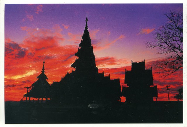
Mae Hong Son, Thailand
Continuing on the lunar year theme... I received this beautiful postcard last year. I was looking for postcards with Year of the Horse stamps and A of Thailand kindly agreed to swap with me.
Mae Hong Son is a town (thesaban mueang) in northwest Thailand, capital of Mae Hong Son Province. It is in the Shan Hills, near the border with Burma along the banks of the River Pai. As of 2005, the town had some 6,023 inhabitants.
Mae Hong Son Province is one of the northern provinces (changwat) of Thailand, on the country's western border. Neighboring provinces are (clockwise from north) Shan State of Myanmar, Chiang Mai and Tak. To the west, the province borders Kayin State and Kayah State of Myanmar.
The name Mae Hong Son means "the city of three mists". It is hemmed in by the high mountain ranges of the Shan Hills and is the most mountainous province in Thailand and is occupies 13,814 square kilometres. The province is covered with mist throughout the year and its terrain is highly suitable for the training of elephants.
Mae Hong Son is a town (thesaban mueang) in northwest Thailand, capital of Mae Hong Son Province. It is in the Shan Hills, near the border with Burma along the banks of the River Pai. As of 2005, the town had some 6,023 inhabitants.
Mae Hong Son Province is one of the northern provinces (changwat) of Thailand, on the country's western border. Neighboring provinces are (clockwise from north) Shan State of Myanmar, Chiang Mai and Tak. To the west, the province borders Kayin State and Kayah State of Myanmar.
The name Mae Hong Son means "the city of three mists". It is hemmed in by the high mountain ranges of the Shan Hills and is the most mountainous province in Thailand and is occupies 13,814 square kilometres. The province is covered with mist throughout the year and its terrain is highly suitable for the training of elephants.
Monday, 16 February 2015
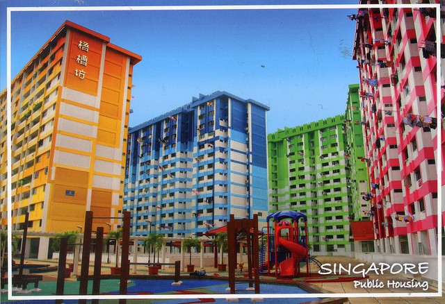
Singapore public housing
I received this postcard earlier this year through the South East Asia RR on the Postcrossing. There was a special group open for Year of the Sheep/Goat stamps and I just couldn't resist joining. I know the postcard isn't sheep-related, but that wasn't a requirement and I really don't mind (although I did feel bad when sending out my cards as I only had a few sheep postcards available; I do realise many people prefer the postcard to match). This card had actually been in my favourites for a while, so I was really pleased to receive it.
I wonder if all public housing in Singapore is this colourful...? ...and whether these blocks of flats are a little nicer than some council block of flats over here... :P Having said that, though, I do wish it was easier to get a council flat here - it's pretty much impossible unless you're in a priority group with special needs. :(
Labels:
2015,
cancellations,
RR,
singapore,
year of the horse,
year of the sheep
Sunday, 21 December 2014
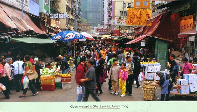
Open market in Shaukeiwan, Hong Kong
A lovely market view from Hong Kong. The main point of this swap were the stamps and the first day cancellation but I really like the card as well.
Shaukeiwan, is a town in the Eastern District, located in the north east of Hong Kong Island. Literally, Shau Kei means a colander, and Wan implies that the town is developed along the coast. Nowadays it is a relatively densely populated town compared with some developing areas.
Labels:
2014,
chinese new year,
hong kong,
markets,
swap,
year of the horse
Subscribe to:
Posts (Atom)


Maroon