Sunday 7 July 2013

Saint Martin

One more post for today... which includes two postcards, the first one being from the swap with Addis in 2008, and the second one being from a swap earlier this year. I thought I'd stay in the same region... :P


Saint Martin (French: Saint-Martin; Dutch: Sint Maarten) is an island in the northeast Caribbean, approximately 300 km east of Puerto Rico. The 87 km2 island is divided roughly 60/40 between France (53 km2) and the Kingdom of the Netherlands (34 km2); they are roughly equal in population. It is one of the smallest sea islands divided between two nations, a division dating to 1648. The southern Dutch part comprises Sint Maarten and is one of four constituent countries that form the Kingdom of the Netherlands. The northern French part comprises the Collectivité de Saint-Martin (Collectivity of St. Martin) and is an overseas collectivity of France.

On January 1, 2009 the population of the entire island was 77,741 inhabitants, with 40,917 living on the Dutch side, and 36,824 on the French side.

Collectively, the two territories are known as "St-Martin / St Maarten". Sometimes SXM, the IATA identifier for Princess Juliana International Airport (the island's main airport), is used to refer to the island.


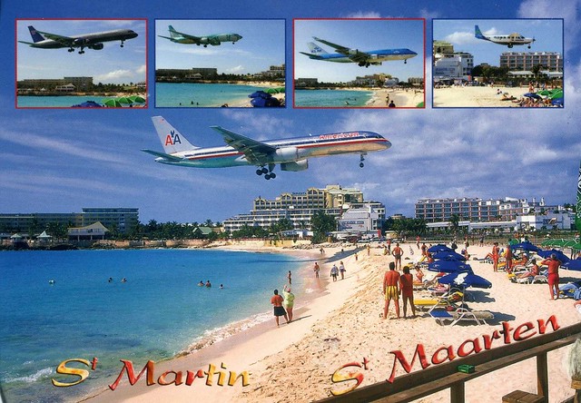
...and here's a view from Maho Bay, a plane landing at Princess Juliana airport, which serves the Dutch part of the island of Saint Martin. In 2007, the airport handled 1,647,824 passengers and 103,650 aircraft movements. The airport serves as a hub for Windward Islands Airways and is the major gateway for the smaller Leeward Islands, including Anguilla, Saba, St. Barthélemy and St. Eustatius. It is named after Juliana of the Netherlands, who as crown princess landed here in 1944, the year after the airport opened. There is also an airport on the French side of the island, called Aéroport de Grand Case or L'Espérance Airport. The airport is perhaps best known for very low-altitude flyover landing approaches due to one end of its runway being extremely close to the shore and Maho Beach.
This is the stamp on the second postcard, sadly not cancelled, but still mailed from Saint Martin. :)

San Juan, Puerto Rico

Postcards from another tropical paradise... this time Puerto Rico. These two cards are slightly older again, from a swap in 2008. I just love this map card, and San Juan looks really pretty as well!


Puerto Rico is an unincorporated territory of the United States, located in the northeastern Caribbean, east of the Dominican Republic and west of both the United States Virgin Islands and the British Virgin Islands. Puerto Rico (Spanish for "rich port") comprises an archipelago that includes the main island of Puerto Rico and a number of smaller islands, the largest of which are Vieques, Culebra, and Mona. The main island of Puerto Rico is the smallest by land area of the Greater Antilles. It ranks third in population among that group of four islands, which include Cuba, Hispaniola (Dominican Republic and Haiti), and Jamaica. Due to its location, Puerto Rico enjoys a tropical climate and is subject to the Atlantic hurricane season. Official languages of the island are Spanish and English, with Spanish being the primary language.


San Juan is the capital and most populous municipality in Puerto Rico, an unincorporated territory of the United States. As of the 2010 census, it had a population of 395,326 making it the 46th-largest city under the jurisdiction of the United States. San Juan was founded by Spanish colonists in 1521, who called it Ciudad de Puerto Rico ("Rich Port City"). Puerto Rico's capital is the second oldest European-established city in the Americas, after Santo Domingo, in the Dominican Republic. Several historical buildings are located in San Juan; among the most notable are the city's former defensive forts, Fort San Felipe del Morro and Fort San Cristóbal, and La Fortaleza, the oldest executive mansion in continuous use in the Americas.

"Old San Juan" is a tourist zone in the capital. Addis, who sent me this card, told me a bit about these streets:

- Calle San Sebastián has a festival every year organized by its residents.
- Calle Fortaleza leads you to the governor's palace (called 'La Fortaleza').
- Calle Cristo has lots of fancy shops.

Chinaman's Hat, Hawaii, USA

This postcard is in the minority in my collection as it wasn't received through Postcrossing - and not even through Facebook! I've been in touch with Anne in Hawaii, swapping zines, stickers and tea, and once I asked her if she had any spare postcards she could send me (I don't have too many from Hawaii and it looks so beautiful there). She did ;) This is one of them, one of my favourites, although it was difficult to pick just one as they are all so beautiful.


Mokoliʻi is a 5.1 ha, 63 m tall basalt island 0.54 km offshore of Kualoa Point, Oahu, in Kāne'ohe Bay, Hawaii. Geologically, it used to be connected to Oahu before erosion cut it off. It is also known as "Chinaman's Hat" for its likeness to the straw hats Chinese immigrants wore. Wedge-tailed Shearwaters are the only species of bird that nests here; previously there were a few.

Mokoliʻi is open to the public from dawn to dusk. On weekends it is somewhat a popular secret with tourists and locals. It can be accessed by kayak, boat, surfboard, or by swimming; depth soundings are only four feet on its west side. This may be dangerous during any other time or inclement weather. The area is home to stonefish, and sharks are often seen around the island, often in early mornings.

Mauritius

This is one of the first postcards I've received through Postcrossing, way back in 2007 (has it really been that long?!), and certainly one of the very first private swap cards. Since then I haven't had too many other cards from Mauritius, either...


I don't have much to say about this card actually, there are no descriptions on the back of the card so I have no idea what these places are. I do really like it, though, and as I said, this card is kinda special to me as it's one of my first Postcrossing postcards. :)

Hakone Tozan Railway, Japan

A gorgeous train postcard I received from the wonderful 'Choose a Country' RR last year. I really like the scenery here as well!


The Hakone Tozan Railway is a private railway company in Japan, part of the Odakyu Group. It is best known for its operation of the Hakone Tozan Line, the first mountain railway in Japan, but like most Japanese railway companies, also operates bus service, namely Hakone Tozan Bus. It also operates the connecting Hakone Tozan Cable Car.

The Hakone Tozan Line consists of two sections: a lower section from Odawara to Hakone-Yumoto, and an upper section from Hakone-Yumoto to Gōra. At Gōra, a cable car is available to transfer visitors to and from Lake Ashi.

Birobidzhan, Jewish Autonomous Oblast, Russia

It seems to be next to impossible to get any postcards from or of certain Russian regions. Jewish Autonomous Oblast is one of those regions, so I'm happy to at least have this Touchnote card I received from Olga in Russia last year.


Birobidzhan is a town and the administrative center of the Jewish Autonomous Oblast, Russia, located on the Trans-Siberian Railway, close to the border with China. It has a population of 75,413 (2010 Census). On this postcard you can see the TV tower and the Bira river in Birobidzhan.

The Jewish Autonomous Oblast is a federal subject of Russia (an autonomous oblast) situated in the Russian Far East, bordering with Khabarovsk Krai and Amur Oblast of Russia and Heilongjiang province of China. Soviet authorities established the autonomous oblast in 1934. It was the result of Joseph Stalin's nationality policy, which provided the Jewish population of the Soviet Union with a large territory in which to pursue Yiddish cultural heritage. According to the 1939 population census, 17,695 Jews lived in the region (16% of the total population). The Jewish population peaked in 1948 at around 30,000, about one-quarter of the region's population.

In 1953 Joseph Stalin died and thereafter the Jewish population in the JAO began a long decline. The census of 1959, revealed that the Jewish population of the JAO had declined by approximately 50%, down to 14,269 persons. In 2002, there were 2,327 people of Jewish descent living in the JAO (1.2% of the total population), while ethnic Russians made up 90% of the JAO population. By 2010, according to data provided by the Russian Census Bureau, there were only 1,628 people of Jewish descent remaining in the JAO (1% of the total population), while ethnic Russians made up 92.7% of the JAO population.

The 2010 Russian Census Bureau data was however, disputed in a recent article of the Jerusalem Post claiming that approximately 4,000 Jews remain in the JAO. According to Rabbi Mordechai Sheiner, Judaism and the Jewish culture have recently begun enjoying a religious and cultural resurgence in the JAO.

La Palma, Canary Islands, Spain

Another postcard from 2009... and another one picked because it's vaguely holiday-related. No, I won't be going to La Palma or even the Canary Islands, but I will be going to Spain at the beginning of September. Me and my husband will be going to Benidorm for a week for holiday. I hope it'll be good and not too much like a touristy hell.. it did sound nice, though, with lots to do, and I'm hoping to visit some of the nearby areas that might seem a bit more "Spanish".. :P And it should be nice and sunny! :D Anyway, I wouldn't mind visiting the Canary Islands at some point, either. My grandma and her husband spent a few months on Tenerife last winter and will be going again this year. I'd love to be able to escape the cold winters as well... :P


La Palma is the most north-westerly of the Canary Islands, Africa. La Palma has an area of 706 km2 making it the fifth largest of the seven main Canary Islands. The total population is about 86,000, of which 18,000 (2003 data) live in the capital, Santa Cruz de la Palma and about 20,000 (2004 data) in Los Llanos de Aridane.

La Palma, like the other islands of the Canary Island archipelago, is a volcanic ocean island. The volcano rises almost 7 km above the floor of the Atlantic Ocean. There is road access from sea level to the summit at 2,426 m, which is marked by an outcrop of rocks called Los Muchachos ("The Lads"). This is the site of the Roque de los Muchachos Observatory, one of the world's premier astronomical observatories.

The local economy is primarily based on agriculture and tourism. Platanos (or Bananas) are grown throughout the island with many banana farms on the western side of the island in the valley of Los Llanos de Aridane. Other crops include: Strelitzia (or 'Bird of Paradise') flowers, oranges, avocados and grapes (which grow well in the volcanic soil). The wine from the grapes is prized. Local ranchers herd cows, sheep and goats (from which they make goat cheese).

Helsinki Cathedral, Helsinki, Finland

This is a slightly older card, received about four years ago from dear Marja in Finland. I really like all the postcards I've seen from this particular series, and I just love the design of this card for some reason. Haha, and I wanted to post something Finland-related as I'll be going there in a month. I'll be staying for a week there, visiting family. I'm really looking forward to it, seeing my family again and all the familiar places as well. Hopefully it'll still be nice and warm as well, it seems like this summer has been pretty good over there so far. ...better than here in England at least, although the past few days have been really hot here and I'm boiling at the moment. Still, I much prefer this to the usual cold, miserable weather. :P


Helsinki Cathedral (Finnish: Helsingin tuomiokirkko, Suurkirkko) is the Finnish Evangelical Lutheran cathedral of the Diocese of Helsinki, located in the neighbourhood of Kruununhaka in the centre of Helsinki, Finland. The church was originally built from 1830-1852 as a tribute to the Grand Duke of Finland, Tsar Nicholas I of Russia. It was also known as St Nicholas' Church until the independence of Finland in 1917.

 A distinctive landmark in the Helsinki cityscape, with its tall, green dome surrounded by four smaller domes, the building is in the neoclassical style. It was designed by Carl Ludvig Engel as the climax of his Senate Square layout: it is surrounded by other, smaller buildings designed by him. The church's plan is a Greek cross (a square centre and four equilateral arms), symmetrical in each of the four cardinal directions, with each arm's façade featuring a colonnade and pediment. Engel originally intended to place a further row of columns on the western end to mark the main entrance opposite the eastern altar, but this was never built.

Today, the cathedral is one of Helsinki's most popular tourist attractions. More than 350,000 people visit the church each year, some to attend religious events, but mostly as tourists. The church is in regular use for services of worship and special events such as weddings.