Showing posts with label norway. Show all posts

Sunday, 26 August 2018

Nordkalotten, Lapland

It has cooled down SO much since I last wrote here.. The heatwave is definitely over, it's not fairly chilly and raining and I've actually had to turn our little heater on because I was so cold. I'm still glad it's not so ridiculously hot anymore as the heat was making me ill... Not that I've been feeling too well recently but that's another story.. :P

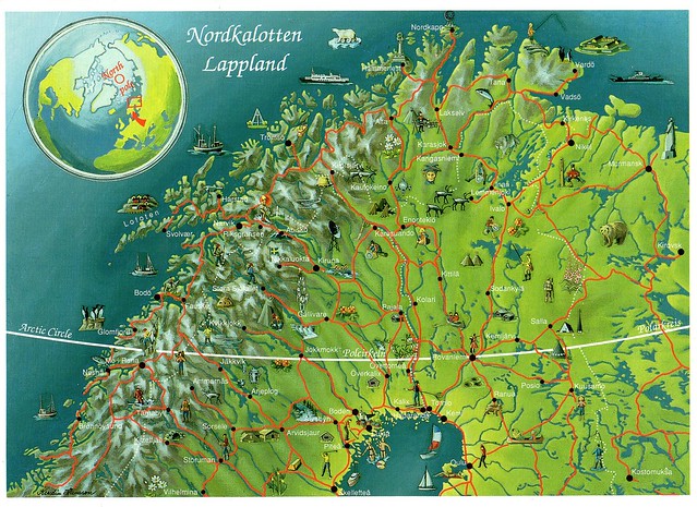
Anyway... I've been meaning to post about this card for a while, I received it last year from 'Tua' in Finland. She was one of my 'summer postcard pals' last summer and I really enjoyed receiving cards from her, they were something different as she lives quite far north in the Finnish Lapland. You can't tell it from here but this card is HUGE so you can actually read the place names and see the little pictures. :)


The Cap of the North (Nordkalotten in Norwegian and Swedish, or Pohjoiskalotti in Finnish) consists of the counties Finnmark, Nordland and Troms in Norway, Norrbotten County in Sweden, Lapland/Lappi Region in Finland and Murmansk Oblast in Russia.

This area is roughly equal to the parts of Fennoscandia (including the Kola Peninsula in Russia) lying north of the Arctic Circle. The region has a subarctic climate and is home to the majority of the Sámi people.

Wednesday, 16 September 2015

sheep, Norway

A random postcard I received last year. I don't really have too much to say about this one except that I really, really like it, and it's always a pleasure to receive a postcard from Catherine in Norway. :)


I do have a bit of a thing for sheep-related postcards, and I think my collection is fairly reasonable. :)

This particular card also has the added bonus of including a stunning view from Norway, what's not to like?!

Friday, 3 April 2015

Akershus, Norway

One more card for today, an absolutely gorgeous view from Norway.


I'm not entirely sure what the exact place on this card is called. On the back of the card it reads "Fløyta, Romeriksåsen, Akershus", but apart from Akershus, I couldn't really find much info.

Akershus is a county in Norway, bordering Hedmark, Oppland, Buskerud, Oslo and Østfold; it also has a short border with Sweden (Värmland). Akershus, with more than half a million inhabitants, is the second largest county by population after Oslo. The county is named after Akershus Fortress. The county administration is in Oslo, which is not part of the county per se.

Sunday, 1 March 2015

Torghatten, Norway

This gorgeous view from Norway had been in my favourites for quite a while so I was really excited to finally receive it earlier this week from Cathrine in Norway. Thank you so much!


Torghatten is a granite mountain on Torget island in Brønnøy municipality in Nordland county, Norway. It is known for its characteristic hole, or natural tunnel, through its center. It is possible to walk up to the tunnel on a well-prepared path, and through it on a natural path.

According to legend, the hole was made by the troll Hestmannen while he was chasing the beautiful girl Lekamøya. As the troll realized he would not get the girl, he released an arrow to kill her, but the troll-king of Sømna threw his hat into the arrow's path to save her. The hat turned into the mountain with a hole in the middle. Also, Felice Vinci has linked the legends about Torghatten to the Homeric myth of Polyphemus.

The tunnel is 160 metres long, 35 metres wide, and 20 metres high. It was formed during the Scandinavian ice age. Ice and water eroded the looser rocks, while the harder ones in the mountain top have resisted erosion.

Saturday, 21 February 2015

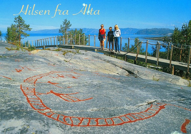
Rock Art of Alta, Norway

This card is from a swap with Joey in Norway a couple of years ago. Unfortunately Joey then disappeared from the Postcrossing forum before I could send a postcard back to him and he never answered my messages. I don't like owing cards to people. :(


The property is situated in the northernmost part of Norway, far north of the Arctic Circle at the head of the Alta Fjord. It contains thousands of rock carvings and paintings located at 45 sites in five different areas at the head of the Alta Fjord (Kåfjord, Hjemmeluft, Storsteinen, Amtmannsnes and Transfarelvdalen). More rock art made by hunter-gatherers is found in Alta than anywhere else in northern Europe. This seems to indicate that for thousands of years, from approximately 5000 B.C. to about the year 0, Alta was an important meeting place far north of the Arctic Circle. The development of carvings in Alta through thousands of years can be related to the post-glacial land upheaval. The oldest carvings are found at the highest points of the landscape. In Alta the changing landscape of prehistoric times is evident, and the position of the carvings also provides a key to understanding the chronology of rock art in the circumpolar region.

The Rock Art shows communication between the world of the living and the worlds of the spirits, and gives insight into the cosmology of prehistoric hunters and gatherers. There is an exceptionally high number of human figures and compelling portrayals of prehistoric social life, dancing, processions, and rituals. Moreover, the Rock Art provides a unique testimony to the interaction of hunter-gatherers with the landscape. The panels show hunting, fishing and boat journeys, and are thought to represent micro-landscapes. A wide range of circumpolar fauna is depicted (reindeer, elks, bears, fish, whales, seabirds, etc.). Studies of material culture are enriched by the many different artefacts shown on the Alta panels. Good preservation conditions permit the study of rock art production.

Investigation of the large settlement sites adjacent to the carvings gives a better understanding of the social context of the Rock Art. The Rock Art and the settlement sites demonstrate communication in prehistory with areas thousands of kilometres away.

Saturday, 4 October 2014

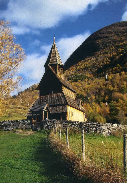
Urnes Stave Church, Norway

I was the Finnish 'winner of the month' on the Postcrossing forum two years ago. This is one of the cards I received and also one of my favourites. I have a soft spot for Norwegian postcards and this one is a Unesco site as well. ...and an ad card from Finland, which I never would've guessed by just looking at the card. It does make me a little sad now as well, because the card was sent by dear Marja who's sadly not with us anymore. I do miss her on the forum :( I hope her family and everyone close to her are ok.


Urnes Stave Church is a 12th-century stave church at Ornes, along the Lustrafjorden in the municipality of Luster in Sogn og Fjordane county, Norway. It sits on the eastern side of the fjord, directly across the fjord from the village of Solvorn and about 5 kilometres east of the village of Hafslo. It has been owned by Fortidsminneforeningen (Society for the Preservation of Norwegian Ancient Monuments) since 1881. In 1979, the Urnes Stave Church was listed as a World Heritage Site by UNESCO.

Saturday, 11 January 2014

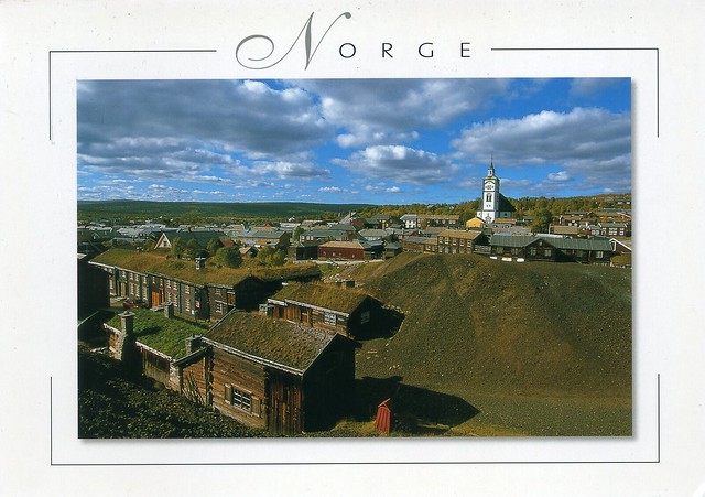
Røros Mining Town, Norway

Ok, I'll try to finish the update I started yesterday. :P ...starting off with this gorgeous Norwegian Unesco card that was one of the cards I received as part of the 'winner of the month' lottery in September last year. It's always such a pleasure to receive postcards from Cathrine, she's so thoughtful and I love it how her cards are so full of writing, too :)


Røros Mining Town and the Circumference is linked to the copper mines, established in the 17th century and exploited for 333 years until 1977. The site comprises the Town and its industrial-rural cultural landscapes; Femundshytta, a smelter with its associated area; and the Winter Transport Route. Completely rebuilt after its destruction by Swedish troops in 1679, Røros contains about 2000 wooden one- and two-storey houses and a smelting house. Many of these buildings have preserved their blackened wooden façades, giving the town a medieval appearance. Surrounded by a buffer zone, coincident with the area of privileges (the Circumference) granted to the mining enterprise by the Danish-Norwegian Crown (1646), the property illustrates the establishment and flourishing of a lasting culture based on copper mining in a remote region with a harsh climate.

Saturday, 30 March 2013

Sørfjorden, Norway

Moving on from Sweden to its neighbour, Norway. I just can't get enough of beautiful Norwegian sceneries, and this one is no exception.


I couldn't find much info about the place on this card.. It shows Sørfjorden (English: Southern Fjord), which is the name of several fjords on the coast of Norway.


Sunday, 16 September 2012

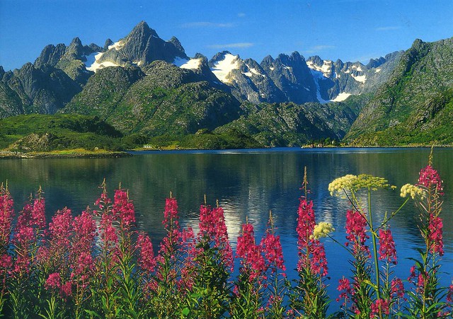
Lofoten, Norway

It's always a treat to receive postcards from Norway, it's SUCH a beautiful country! This card arrived through a swap earlier this year. Thank you so much, Grethe!


Lofoten is an archipelago and a traditional district in the county of Nordland, Norway. Though lying within the Arctic Circle, the archipelago experiences one of the world's largest elevated temperature anomalies relative to its high latitude. It is well known for its natural beauty within Norway.

Lofoten encompasses the municipalities of Vågan, Vestvågøy, Flakstad, Moskenes, Værøy and Røst. The total land area amounts to 1,227 km², and the population totals 24,500. Many will argue that Hinnøya, the northern part of Austvågøy and several hundred smaller islands, skerries and rocks to the east of Austvågøy are also part of the Lofoten complex. Historically the territorial definition of Lofoten has changed significantly. Between the mainland and the Lofoten archipelago lies the vast, open Vestfjorden, and to the north is Vesterålen. The principal towns in Lofoten are Leknes in Vestvågøy and Svolvær in Vågan. The Lofoten Islands are characterised by their mountains and peaks, sheltered inlets, stretches of seashore and large virgin areas. The highest mountain in Lofoten is Higravstinden (1,161 m) in Austvågøy; the Møysalen National Park just northeast of Lofoten has mountains reaching 1,262 m. The famous Moskstraumen (Malstrøm) system of tidal eddies is located in western Lofoten, and is indeed the root of the term maelstrom.

Thursday, 10 May 2012

Store Trolltind & Trollfjord, Norway

A GORGEOUS Norway view from a swap earlier this year. Thank you so much, Sissel, I absolutely adore this card!

Store Trolltind is the highest point along the Trolltindane ridge. It has the vertical Trollveggen cliff separating the peak from the Romsdalen valley below, a drop of about 1,700 metres which makes it the highest vertical cliff in Europe.

The Trollfjord (Trollfjorden) is a 2 km long sidearm of the Raftsund between the Norwegian archipelagos of Lofoten and Vesterålen. With its narrow entrance and steep-sided mountains, Trollfjord cuts westwards from the Raftsundet strait. The name is derived from troll, a figure from Norse mythology.

Sunday, 8 April 2012

Ålesund, Norway

A gorgeous, HUGE postcard I received from the 'Choose a Country' RR on the Postcrossing forum earlier this year. What a magnificent city Ålesund looks like! ...and speaking of the abovementioned RR, I'm so excited Peggy is organising another surprise group again!


Ålesund is a town and municipality in Møre og Romsdal county, Norway. It is part of the traditional district of Sunnmøre, and the center of the Ålesund Region. It is a sea port, and is noted for its unique concentration of Art Nouveau architecture.

Ålesund town is the administrative centre of the municipality as well as the principal shipping town of the Sunnmøre district. Ålesund municipality has a population of 42,982 as of 2010, while the greater Ålesund area has a population of 47,772 (this also includes most of neighboring Sula as well).

The municipality of Ålesund occupies seven of the outer islands in the county of Møre og Romsdal: Hessa, Aspøya, Nørvøya, Oksnøya, Ellingsøya, Humla, and Tørla. The town centre is located on the islands Aspøya and Nørvøy, while Heissa and Oksnøya contain residential areas.

The second largest island, Elingsøya, used to be accessible only by boat or by road via Skodje municipality, but an undersea tunnel was built in 1987 to make travelling between the island and the town centre more convenient. The tunnel is 3,481 metres long, and was upgraded in 2009.

Situated 236 km north northeast of Bergen, Ålesund is adjacent to the Hjørund and Geiranger fjords, the latter being on UNESCO's list of World Heritage Sites.

Ålesund has the most important fishing harbour in Norway. The town's fishing fleet is one of the most modern in Europe. Ålesund and surroundings also has a large furniture industry. Some well-known household items are manufactured here.

Saturday, 10 March 2012

Tromsø, Norway

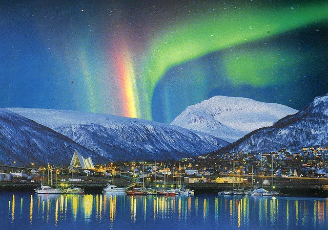
This AWESOME card arrived in a swap earlier this year. I totally adore it, it looks like something out of a fairytale with all those lights and snow, and the amazing northern lights. Thank you so much, Sissel! Oh, and... I'm always looking for more postcards from Norway so if you are reading this and want to swap, get it touch!


Tromsø is a city and municipality in Troms county, Norway. The administrative centre of the municipality is the city of Tromsø.

Tromsø city is the ninth largest urban area in Norway by population, and the seventh largest city in Norway by population. It is the largest city and the largest urban area in Northern Norway, and the second largest city and urban area in Sápmi (following Murmansk). Most of Tromsø, including the city centre, is located on the small island of Tromsøya in the county of Troms, 350 kilometres inside the arctic circle. Substantial parts of the urban area are also situated on the mainland to the east, and on parts of Kvaløya - a large island to the west. Tromsøya is connected to the mainland by the Tromsø Bridge and the Tromsøysund Tunnel, and to the island of Kvaløya by the Sandnessund Bridge. The city is warmer than most other places located on the same latitude, due to the warming effect of the Gulf Stream.

The city centre of Tromsø contains the highest number of old wooden houses in Northern Norway, the oldest house dating from 1789. The Arctic Cathedral, a modern church from 1965, is probably the most famous landmark in Tromsø. The city is a cultural centre for its region, several festivals taking place in the summer. Some of Norways most known musicians, Torbjørn Brundtland and Svein Berge of the electronica duo Röyksopp, both grew up and started their careers in Tromsø.

Saturday, 7 January 2012

Nordkapp, Norway

The Finnish community on the Postcrossing forum has this little project called 'Kesäkorttikaveri' ('summer card pal') every year where you can exchange postcards during the summer with one or several people. Usually people "pair up" themselves and decide how often they send cards to each other. I've participated in it a few times and always really enjoy it, I've met some lovely people that way (and I still exchange cards with one of them!). In summer 2011 one of my card pals was Nina. She visited Norway during that summer and sent me this lovely postcard from there.


Nordkapp (North Cape) is a cape on the island of Magerøya in Northern Norway, in the municipality of Nordkapp. Its 307 metres high, steep cliff is often referred to as the northernmost point of Europe, located at 71°10′21″N 25°47′40″E, 2,102.3 kilometres from the North Pole. However, the neighbouring point Knivskjellodden is actually 1,457 metres farther north. Moreover, both of these points are situated on an island, which means the northernmost point of mainland Europe is in fact Cape Nordkinn (Kinnarodden), about 20 kilometres from the village of Mehamn on Nordkinn Peninsula.

The North Cape is the point where the Norwegian Sea, part of the Atlantic Ocean, meets the Barents Sea, part of the Arctic Ocean.

Thursday, 8 December 2011

Longyearbyen, Svalbard, Norway

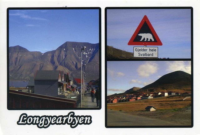
Today's last card made me really excited when I received it. When I had joined the RR on the Postcrossing forum, I didn't realise Spitsbergen was in Svalbard and I never thought I'd ever get a postcard from there. ...and then this gem arrived! :)


Longyearbyen is the largest settlement and the administrative centre of Svalbard, Norway. It is located on the western coast of Spitsbergen, the largest island of the Svalbard archipelago, on the southern side on Adventfjorden , which continues inland with Adventdalen . The Governor of Svalbard and his administration reside in Longyearbyen.

Longyearbyen has approximately 2,060 inhabitants (at the end of 2007). It is the world's most northerly town, and the most northerly settlement with a population greater than 1,000.

Svalbard is an archipelago in the Arctic, constituting the northernmost part of Norway. It is located north of mainland Europe, midway between mainland Norway and the North Pole. The group of islands range from 74° to 81° north latitude (inside the Arctic Circle), and from 10° to 35° east longitude. Spitsbergen is the largest island, followed by Nordaustlandet and Edgeøya. The administrative center is Longyearbyen, and other settlements include the Russian mining community of Barentsburg, the research community of Ny-Ålesund and the mining outpost of Sveagruva. The archipelago is administered by the Governor of Svalbard.

The islands were first utilized as a whaling base in the 17th and 18th centuries, after which they were abandoned. Coal mining started at the beginning of the 20th century, and several permanent communities were established. The Spitsbergen Treaty of 1920 recognizes Norwegian sovereignty, and the 1925 Svalbard Act made Svalbard a full part of the Kingdom of Norway. This act also established Svalbard as a free economic zone and a demilitarized zone. The Norwegian Store Norske and the Russian Arktikugol are the only mining companies remaining on the islands. Research and tourism have become important supplementary industries. Two major research facilities are the University Centre in Svalbard and the Svalbard Global Seed Vault. No roads connect the settlements; instead snowmobiles, aircraft and boats serve inter-community transport. Svalbard Airport, Longyear serves as the main gateway to the rest of Europe.

The archipelago features an Arctic climate, although with significantly higher temperatures than other areas at the same latitude. The flora take advantage of the long period of midnight sun to compensate for the polar night. Svalbard is a breeding ground for many seabirds, and also features polar bears, reindeer and marine mammals. Seven national parks and twenty-three nature reserves cover two-thirds of the archipelago, protecting the largely untouched, yet fragile, nature. Sixty percent of the archipelago is glacier, and the islands feature many mountains and fjords.

Thursday, 6 October 2011

Bugøynes, Norway

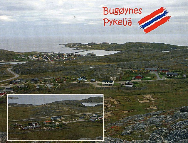
I thought I'd throw in an older card again. This one is from my parents from their trip to northern Norway about two years ago.


Bugøynes (Pykeijä in Finnish) is a fishing community in the very most northeastern tip of Norway, in the municipality of Sør-Varanger in the province of Finnmark, situated by the Varanger Fjord which is a vast bay off the Barents Sea (a part of the Arctic Ocean), near the border with Russia. The village is situated some 500 km north of the Arctic Circle, with nearly 230 inhabitants.

Before the road was built to Bugøynes in 1962, the main link between Bugøynes and the rest of the world was by sea. The most-visited town in those days was Vadsø, on the opposite side of the Varanger Fjord. Although Kirkenes, on the south side of the fjord, was the local administrative centre for Bugøynes, it did not become the centre for shopping until people could reach it by car.

Now most trade in this part of Finnmark takes place in Kirkenes. Workplaces in Bugøynes include fishing, salmon and other fish processing, the processing of reindeer meat and game, as well as slipway and machine workshops.

I seem to remember my parents mentioning visiting a fishing boat or similar where the catch included HUGE crabs - one of them weighed more than 9 kg!


The stamp on the right is from a set of 2 stamps issued in 2009, under the theme 'Norwegian Year of Cultural Heritage'. The stamp here shows a radio. The smaller stamp on the left is from a set of 3 definitives issued in 2001.

Wednesday, 11 May 2011

Borgund Stave Church, Norway

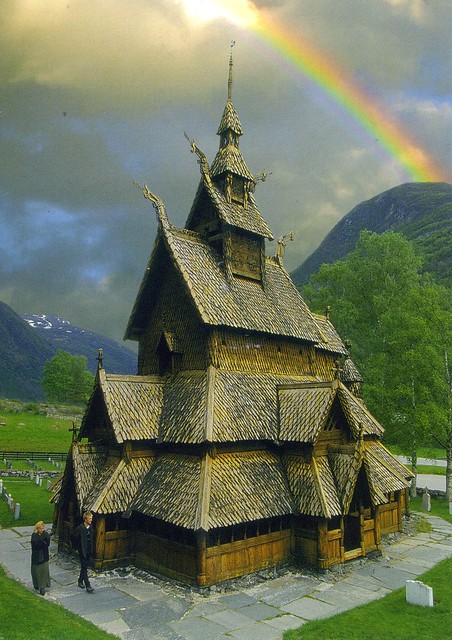
Another official, but this one is much older, back from 2008. It's from Joey who used to be the most active postcrosser in Norway, but he's since left Postcrossing, which is a shame as he was such a nice guy. I've received a few cards from him and they are all great.


NO-17520


Borgund Stave Church is a stave church located in Borgund, Lærdal, Norway. It is classified as a triple nave stave church of the so-called Sogn-type. This is also the best preserved of Norway's 28 extant stave churches.

Borgund was built sometime between AD 1180 and 1250 with later additions and restorations. Its walls are formed by vertical wooden boards, or staves, hence the name stave church. The 4 corner posts were connected to one another by ground sills, resting atop a stone foundation. The rest of the staves then rise from the ground sills, each stave notched and grooved along the sides so that they lock into one another, forming a sturdy wall.

Borgund has tiered, overhanging roofs, topped with a tower. On the gables of the roof, there are four carved dragon heads, swooping from the carved roof ridge crests, recalling the carved dragon heads found on the prows of Norse ships. Similar gable heads also appear on small bronze house shaped reliquaries common in Norway in this period. Borgund’s current dragon heads possibly date from the 18th century, however original dragon heads remaining on earlier structures, such as the stave church at Lom stave church and nearby Urnes stave church, the oldest still extant stave church, also in the Sogn district, suggest that there probably would have been similar dragon heads there at one time. Borgund is one of the only churches to still have preserved its ridge crests, carved with openwork vine and vegetal repeating designs.


The stamp on the right is from a set of 4 stamps issued in 2008, with the theme 'Transport'. The other one I couldn't find any info of.

Saturday, 29 January 2011

Hell, Norway

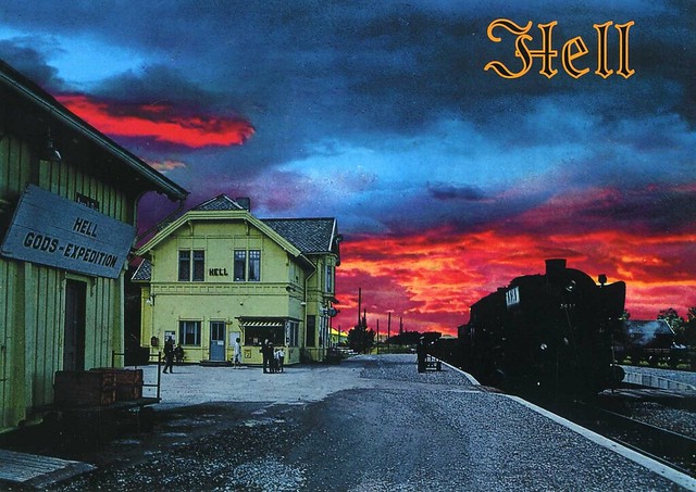
One more card for today.. a postcard from Hell!


I had this postcard in my favourites for a very long time, I'm so happy to finally have it! It's not mailed directly from Hell (now there's a sentence I never thought I would write :D), but it's still a treasure, and a very beautiful card with the strong colours of the sunset.

Hell is a village in Lånke, Stjørdal, Norway with a population of about 1500 people. It has become a minor tourist attraction because of its name, as visitors often have their photograph taken in front of the station sign. The station sign reads "Gods-expedition", an archaic Norwegian spelling of the word for "cargo handling" - godsekspedisjon would be the current spelling.

The name Hell stems from the Old Norse word hellir, which means "overhang", "cliff cave". The Norwegian word hell in its everyday usage means "luck", in any way pronounced. The Old Norse word Hel is the same as today's English Hell, and as a proper noun, Hel was the ruler of Hel. In modern Norwegian the word for hell is helvete.

The station itself, Hell Station, is situated at a railway junction where the rail line Nordlandsbanen north to Bodø branches off from Meråkerbanen between Trondheim and Storlien in Sweden. Hell station is currently a manned railway station.

Hell is a post town with two post codes: 7517 for delivery route addresses and 7570 for P. O. Boxes. Hell currently has a grocery store, gas station and a retirement home (ah yeah, you could retire in Hell!).

It's a bit unnerving how much the Hell railway station reminds of the railway station in Savonlinna. It looks quite similar, but the one in Savonlinna has been closed for years now. I don't know if things have changed since I moved away, but I remember when they closed it, it became very difficult to buy train tickets as the Finnish state-owned railway company refused to install a ticket machine there. You could buy tickets from a kiosk there if I remember correctly, but they charged a fee to do that, and it had to be done a few days in advance, same as with buying a ticket online (and what were you supposed to do if you didn't have a printer?!). I would usually just buy my ticket on the train as it still cost the same, but that wasn't always ideal as that way you couldn't get a guaranteed seat in the second, much busier train. I'm SO glad I don't live in Savonlinna anymore, although overall I much prefer the Finnish railway network to the system here in the UK, over here it's a total mess and I can hardly ever afford trains over here.


Anyway, back to the postcard... The stamp is from a set of 6 stamps issued in 2009 with the theme Tourism. The stamp here shows Stottafjorden in Meloy, Nordland.
Sunday, 26 September 2010

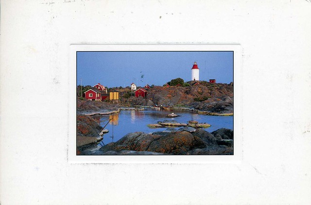
Landsort, Sweden

I've been pretty lucky recently - I've participated in lotteries on the postcrossing forum and I've actually won three in a relatively short space of time! I think I should host my own lottery some time soon.. Last time I did it was so much fun! Anyway, this is one of the cards I've won.


Landsort is a Swedish village and a lighthouse on the island of Öja. The tower was built in 1689, with an upper conical iron section added in 1870. Open fires have been lit here since a long time ago.

The first "real" lighthouse was lit in 1651, and until the now standing tower was built a couple of different buildings was used as a lighthouse. The 1689 tower was constructed to carry an open fire which ran on coal. In 1840, a colza oil lamp was installed. The flame ran on paraffin from 1887, and in 1938 it was electrified. Today the Swedish Maritime Administration owns and runs the lighthouse.

I've lived next to Sweden most of my life and yet I only have a few postcards from Sweden. A bit strange... I have a couple from my parents when they've visited Stockholm, but that's about it. It's strange how Postcrossing has never picked up in Sweden. Maybe it's the expensive stamp prices? Surely it can't be a lack of postcards or anything like that - a Finnish postcrosser told me that postcards are actually cheaper in Sweden than in Finland. It would be nice to see more postcards from Sweden!


This card was mailed from Norway (and had a cute little Norwegian flag sticker on the back of the card :)). The stamp is from a set of 3 stamps issued in 2008, depicting Wildlife in Norway. This one here is the Elk.

Sunday, 1 August 2010

Geirangerfjorden, Norway

Another cool card I've received recently... This one is from the lovely Iina, she sent this to me from her holiday in Norway. I have such lucky friends - they get to visit such cool places! Don't get me wrong, I'm very excited to get to go to Finland in two weeks but it's hardly exotic (and everyone already has tons of postcards from Finland :P).


The Geiranger fjord (Geirangerfjorden) is a fjord in the Sunnmøre region, located in the southernmost part of the county Møre og Romsdal in Norway. It is a 15 km long branch of the Storfjord (Great Fjord). At the head in the fjord lies the small village of Geiranger.

The fjord is one of Norway's most visited tourist sites and has been listed as a UNESCO Heritage Site, jointly with Nærøyfjord, since 2005, although this status is now threatened by the disputed plans to build power lines across the fjord.
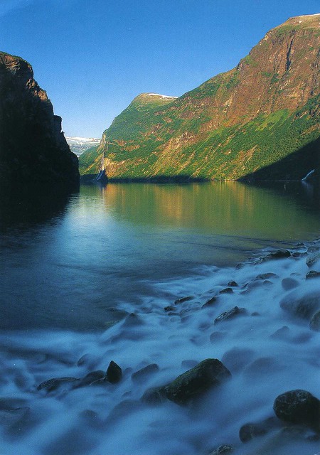
The Geirangerfjord is under constant threat from the mountain Åkerneset which is about to erode into the fjord. A collapse would produce a tsunami, hitting several nearby towns including Geiranger and Hellesylt in about ten minutes.

Along the fjord's sides there lie a number of now abandoned farms. Some restoration has been made by the 'Storfjordens venner' association. The most commonly visited among these are Skageflå, Knivsflå, and Blomberg. Skageflå may also be reached on foot from Geiranger, while the others require a boat excursion. The fjord is also host to several impressive waterfalls.


The stamp is gorgeous, too. It's from a set of 3 stamps issued in 2008, depicting Wildlife in Norway. Here you can see the Elk.