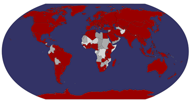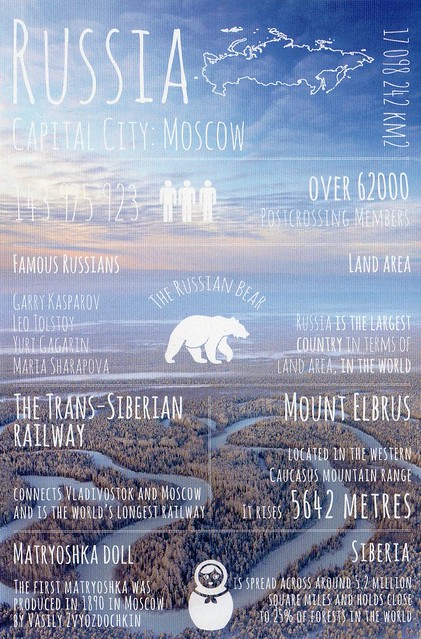
I somehow ended up with three of these! :O I'm quite surprised as well that it took as long as it took for this card to be made, seeing as Russia is the biggest (?) Postcrossing country at the moment, and has been for a while.
I've got a bit of a soft spot for Matryoshka dolls, I think they are really nice. I remember having one when I was a child, I wonder what's happened to it? I would love a new one but the ones I've seen in shops here have been pretty expensive and I just haven't had the spare cash. It's getting easier to find matryoshka-themed things, though, which I don't mind at all. :)
The Trans-Siberian Railway is a network of railways connecting Moscow with the Russian Far East and the Sea of Japan. With a length of 9,289 km, it is the longest railway line in the world. There are connecting branch lines into Mongolia, China and North Korea. It has connected Moscow with Vladivostok since 1916, and is still being expanded.
It was built from 1891 to 1916 under the supervision of Russian government ministers who were personally appointed by Tsar Alexander III and by his son, Tsar Nicholas II. Even before it had been completed, it attracted travellers who wrote of their adventures.
Wednesday, 9 September 2015
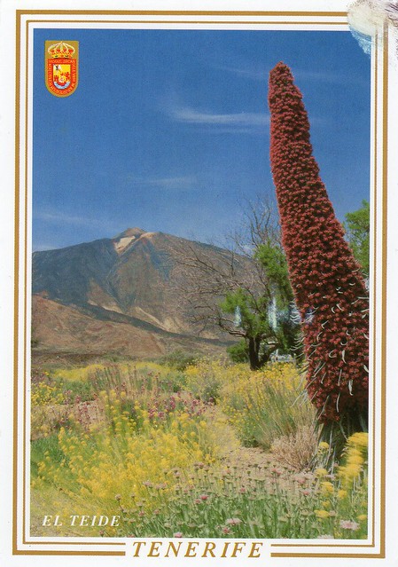
Teide National Park, Spain
A swap card from earlier this year. It's taken me a while to get a postcard of Teide National Park... My grandma has spent a few winters in Tenerife now but I've never got round to asking her, for various reasons. Well, I finally have one. :)
Teide National Park is a national park located in Tenerife (Canary Islands, Spain). It is centered on 3718 m Mount Teide, the highest mountain of Spain and the islands of the Atlantic (it is the third largest volcano in the world from its base on the ocean floor). It was declared a national park on 22 January 1954, making it one of the oldest national parks in Spain. It is also the largest national park in Spain and an important part of the Canary Islands. Another volcano located in the park (next to the Teide) is the Pico Viejo. It is the second largest volcano in the Canary Islands with its 3,135 m peak.
The park has an area of 18,990 hectares and was named a World Heritage Site by UNESCO on June 28, 2007. Since the end of 2007, it has also been one of the 12 Treasures of Spain. Midway up the mountain are the telescopes of the Observatorio del Teide. Territorially, it belongs to the municipality of La Orotava.
Teide is the most visited national park in Spain, with a total of 2.8 million visitors, according to the Instituto Canario de Estadística (ISTAC), and it is one of the most visited national parks in the world. The Teide is the most famous natural icon not only of Tenerife but also of all the Canary Islands.
Teide National Park is a national park located in Tenerife (Canary Islands, Spain). It is centered on 3718 m Mount Teide, the highest mountain of Spain and the islands of the Atlantic (it is the third largest volcano in the world from its base on the ocean floor). It was declared a national park on 22 January 1954, making it one of the oldest national parks in Spain. It is also the largest national park in Spain and an important part of the Canary Islands. Another volcano located in the park (next to the Teide) is the Pico Viejo. It is the second largest volcano in the Canary Islands with its 3,135 m peak.
The park has an area of 18,990 hectares and was named a World Heritage Site by UNESCO on June 28, 2007. Since the end of 2007, it has also been one of the 12 Treasures of Spain. Midway up the mountain are the telescopes of the Observatorio del Teide. Territorially, it belongs to the municipality of La Orotava.
Teide is the most visited national park in Spain, with a total of 2.8 million visitors, according to the Instituto Canario de Estadística (ISTAC), and it is one of the most visited national parks in the world. The Teide is the most famous natural icon not only of Tenerife but also of all the Canary Islands.
Labels:
2015,
canary islands,
national parks,
spain,
swap,
tenerife,
unesco
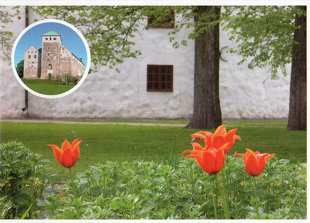
Turku Castle, Finland
I've been participating in the 'summer card pal' project in the Finnish community on the Postcrossing forum again this summer. I've had two 'summer card pals' this summer, and it's been really nice again. I seem to prefer receiving more than one card from someone and actually getting to know people, rather than having a lot of one-off encounters (which kind of makes the official side of Postcrossing pointless for me, although I did send a couple of officials again recently).
This card is from Susanna. She visited the Turku Castle this summer and sent me a card from there - and actually got me a special cancellation as well! :)
Turku Castle (Finnish: Turun linna, Swedish: Åbo slott) is a medieval building in the city of Turku in Finland. Together with Turku Cathedral, the castle is one of the oldest buildings still in use in Finland. Turku Castle is the largest surviving medieval building in Finland. It was founded in the late 13th century and stands on the banks of the Aura River.
Sunday, 6 September 2015
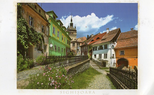
Sighișoara, Romania
Today's last card was a surprise from my friend Astrid, who attended a Postcrossing meet-up in Romania. I had no idea she was planning on going there! It must have been a pretty interesting place to visit as well, and looks very beautiful.
Sighișoara is a city on the Târnava Mare River in Mureș County, Romania. Located in the historic region of Transylvania, Sighișoara has a population of 28,102 according to the 2011 census.
Historic Centre of Sighişoara is a Unesco site. Founded by German craftsmen and merchants known as the Saxons of Transylvania, Sighişoara is a fine example of a small, fortified medieval town which played an important strategic and commercial role on the fringes of central Europe for several centuries.
Transylvania is a historical region in the central part of Romania. Bounded on the east and south by its natural borders, the Carpathian mountain range, historical Transylvania extended in the west to the Apuseni Mountains; however, the term sometimes encompasses not only Transylvania proper, but also the historical regions of Crișana, Maramureș, and Romanian part of Banat. The region of Transylvania is known for the scenic beauty of its Carpathian landscape and its rich history. In the English-speaking world it has been commonly associated with vampires, chiefly due to the influence of Bram Stoker's famous novel Dracula as well as the many later film adaptations.
Sighișoara is a city on the Târnava Mare River in Mureș County, Romania. Located in the historic region of Transylvania, Sighișoara has a population of 28,102 according to the 2011 census.
Historic Centre of Sighişoara is a Unesco site. Founded by German craftsmen and merchants known as the Saxons of Transylvania, Sighişoara is a fine example of a small, fortified medieval town which played an important strategic and commercial role on the fringes of central Europe for several centuries.
Transylvania is a historical region in the central part of Romania. Bounded on the east and south by its natural borders, the Carpathian mountain range, historical Transylvania extended in the west to the Apuseni Mountains; however, the term sometimes encompasses not only Transylvania proper, but also the historical regions of Crișana, Maramureș, and Romanian part of Banat. The region of Transylvania is known for the scenic beauty of its Carpathian landscape and its rich history. In the English-speaking world it has been commonly associated with vampires, chiefly due to the influence of Bram Stoker's famous novel Dracula as well as the many later film adaptations.
Labels:
2015,
friends,
romania,
sighișoara,
transylvania,
unesco
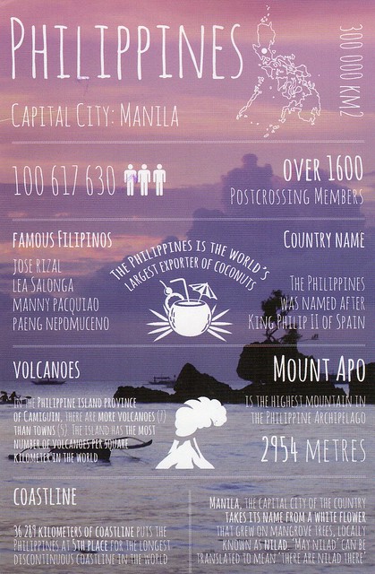
Greetings from Philippines
I know I've said this before but now I really think I'll have to give up on trying to get all the 'Greetings from' postcard from Postallove sent from their respective countries of origin. It's just getting far too difficult. The next batch will include Peru, South Africa, Iceland, Slovakia, Romania and New Zealand. New Zealand seems to be the only country out of those six that I will have any chances of getting. I'm a little annoyed but then, they *are* just postcards after all, aren't they?! :P
Manila is the capital city of the Philippines. It is one of the sixteen cities which, along with the municipality of Pateros, make up Metro Manila, the National Capital Region, that has an overall population of around 12 million.
Mount Apo is a large solfataric, potentially active stratovolcano in the island of Mindanao, Philippines. With an elevation of 2,954 metres above sea level, it is the highest mountain in the Philippine Archipelago and is located between Davao City and Davao del Sur province in Region XI and Cotabato province in Region XII. The peak overlooks Davao City 45 kilometres to the northeast, Digos City 25 kilometres to the southeast, and Kidapawan City 20 kilometres to the west.
Manila is the capital city of the Philippines. It is one of the sixteen cities which, along with the municipality of Pateros, make up Metro Manila, the National Capital Region, that has an overall population of around 12 million.
Mount Apo is a large solfataric, potentially active stratovolcano in the island of Mindanao, Philippines. With an elevation of 2,954 metres above sea level, it is the highest mountain in the Philippine Archipelago and is located between Davao City and Davao del Sur province in Region XI and Cotabato province in Region XII. The peak overlooks Davao City 45 kilometres to the northeast, Digos City 25 kilometres to the southeast, and Kidapawan City 20 kilometres to the west.
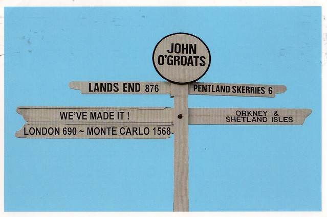
John o'Groats, Scotland
Just a small post for today as I want to go to bed early. I'll start off with this card I received from Matt's parents last month from their holiday. They went to northern Scotland for two weeks and also visited John o'Groats.
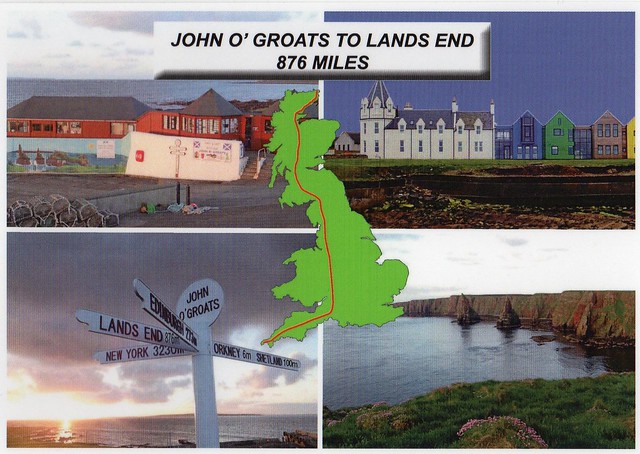
John o' Groats (Gaelic: Taigh Iain Ghròt) is a village in the Canisby parish of Caithness, in the far north of Scotland. John o' Groats lies on Britain's northeastern tip, and is popular with tourists as one end of the longest distance between two inhabited British points, with Land's End in Cornwall lying 876 miles to the southwest. It is not quite the most northerly point on the island of Britain; nearby Dunnet Head is further north.
John o' Groats is 1,110 km from London, 450 km from Edinburgh, 9.7 km from the Orkney Isles and 3,500 km from the North Pole. It is 6.84 km from the uninhabited island of Stroma. A passenger ferry operates from John o' Groats to Burwick on South Ronaldsay in Orkney.
Matt's parents also gave me a bunch of postcards when they got back home. This is one of them and possibly my favourite:
Matt's dad told me the postcard was supposed to be cancelled with a John o'Groats cancellation. I first thought I didn't get the cancellation, but I think it is there, you can just about see it as it's very faint.
John o' Groats (Gaelic: Taigh Iain Ghròt) is a village in the Canisby parish of Caithness, in the far north of Scotland. John o' Groats lies on Britain's northeastern tip, and is popular with tourists as one end of the longest distance between two inhabited British points, with Land's End in Cornwall lying 876 miles to the southwest. It is not quite the most northerly point on the island of Britain; nearby Dunnet Head is further north.
John o' Groats is 1,110 km from London, 450 km from Edinburgh, 9.7 km from the Orkney Isles and 3,500 km from the North Pole. It is 6.84 km from the uninhabited island of Stroma. A passenger ferry operates from John o' Groats to Burwick on South Ronaldsay in Orkney.
Matt's parents also gave me a bunch of postcards when they got back home. This is one of them and possibly my favourite:
Matt's dad told me the postcard was supposed to be cancelled with a John o'Groats cancellation. I first thought I didn't get the cancellation, but I think it is there, you can just about see it as it's very faint.
Wednesday, 12 August 2015
Hairat Khan Jahan Ali Nine Gambuj Mosque, Bangladesh
Today's last card is from a swap with Md. Imran in Bangladesh. Thank you so much, this is beautiful!
This is the Hairat Khan Jahan Ali Nine Gambuj Mosque. I have been trying to work out whether it's one of the mosques of the Unesco site 'Historic Mosque City of Bagerhat', but so far with no luck. If anyone here knows, please let me know, I would be really grateful!
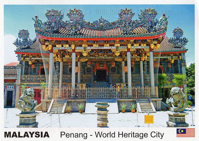
Penang, Malaysia
I received this postcard from Matthew in Malaysia through the SouthEast Asia RR on the Postcrossing forum. I was honestly quite surprised to receive this - the value of the stamp is way above the rate of sending a postcard in Malaysia. It is lovely, though, thank you a million again, Matthew!
George Town (also less commonly spelt as Georgetown) is the capital and largest city of the state of Penang in Malaysia.
George Town is known as the city of condos and apartments in Malaysia like Singapore and Hong Kong. Trishaws and foreigners are also seen in Penang like in Malacca. The Hip Hop Open Air and Rapid Penang buses are the public transports for Penang. George Town is also the district capital of North East Penang Island.
Named after Britain's King George III, George Town is located on the north-east corner of Penang Island. The inner city has a population of 510,996 and the metropolitan area known as George Town Conurbation which consists of Jelutong, Sungai Pinang, Sungai Nibong, Glugor, Air Itam, Tanjung Bungah and Tanjung Tokong have a combined population of 2,251,792, making it the second largest metropolitan area in Malaysia.
The settlement was declared a city in 1957 by Her Majesty Queen Elizabeth II. In 2015, Penang island, on which George Town is located, was also awarded city status.
The inner city of George Town is a UNESCO World Heritage Site.
Khoo Kongsi is a large Chinese clanhouse with elaborate and highly ornamented architecture. It is located in Cannon Square in the heart of the oldest part of the city of George Town, hidden amidst the crowded gridiron of terrace houses and shophouses.
George Town (also less commonly spelt as Georgetown) is the capital and largest city of the state of Penang in Malaysia.
George Town is known as the city of condos and apartments in Malaysia like Singapore and Hong Kong. Trishaws and foreigners are also seen in Penang like in Malacca. The Hip Hop Open Air and Rapid Penang buses are the public transports for Penang. George Town is also the district capital of North East Penang Island.
Named after Britain's King George III, George Town is located on the north-east corner of Penang Island. The inner city has a population of 510,996 and the metropolitan area known as George Town Conurbation which consists of Jelutong, Sungai Pinang, Sungai Nibong, Glugor, Air Itam, Tanjung Bungah and Tanjung Tokong have a combined population of 2,251,792, making it the second largest metropolitan area in Malaysia.
The settlement was declared a city in 1957 by Her Majesty Queen Elizabeth II. In 2015, Penang island, on which George Town is located, was also awarded city status.
The inner city of George Town is a UNESCO World Heritage Site.
Khoo Kongsi is a large Chinese clanhouse with elaborate and highly ornamented architecture. It is located in Cannon Square in the heart of the oldest part of the city of George Town, hidden amidst the crowded gridiron of terrace houses and shophouses.
Labels:
2015,
cancellations,
george town,
malaysia,
penang,
RR,
stamps,
year of the sheep
Greetings from Indonesia
I somehow ended up with two 'Greetings from' Indonesia cards. Ooops. I don't really mind, though, as they are both lovely - beautiful stamps and gorgeous decorations on the back. ^_^
I had to look up the symbol in the middle as I seem to remember there was initially a picture of a coconut tree there but it was changed. This is what I found, and I think it's pretty cool:
Bhinneka Tunggal Ika is the official national motto of Indonesia. The phrase is Old Javanese translated as "Unity in Diversity". It is inscribed in the Indonesian national symbol, Garuda Pancasila (written on the scroll gripped by the Garuda's claws), and is mentioned specifically in article 36A of the Constitution of Indonesia. The Garuda is a mythical bird and the mount of Lord Vishnu.
It is a quotation from an Old Javanese poem Kakawin Sutasoma, written by Mpu Tantular during the reign of the Majapahit empire sometime in the 14th century, under the reign of King Rājasanagara, also known as Hayam Wuruk. Kakawin contains epic poems written in metres.
This poem is notable as it promotes tolerance between Hindus (especially Shivaites) and Buddhists.
...and the stamps on the second card:
I had to look up the symbol in the middle as I seem to remember there was initially a picture of a coconut tree there but it was changed. This is what I found, and I think it's pretty cool:
Bhinneka Tunggal Ika is the official national motto of Indonesia. The phrase is Old Javanese translated as "Unity in Diversity". It is inscribed in the Indonesian national symbol, Garuda Pancasila (written on the scroll gripped by the Garuda's claws), and is mentioned specifically in article 36A of the Constitution of Indonesia. The Garuda is a mythical bird and the mount of Lord Vishnu.
It is a quotation from an Old Javanese poem Kakawin Sutasoma, written by Mpu Tantular during the reign of the Majapahit empire sometime in the 14th century, under the reign of King Rājasanagara, also known as Hayam Wuruk. Kakawin contains epic poems written in metres.
This poem is notable as it promotes tolerance between Hindus (especially Shivaites) and Buddhists.
...and the stamps on the second card:
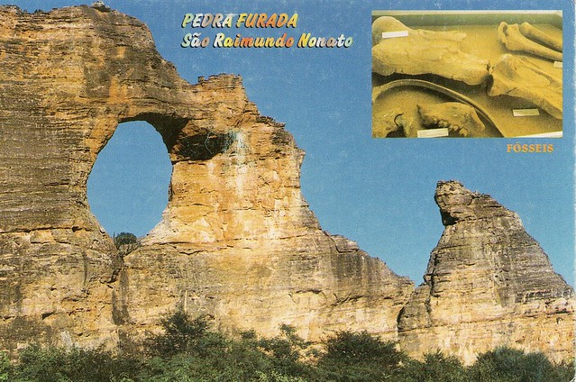
Serra da Capivara National Park, Brazil
A nice Unesco card I received last month. My Unesco collection has been growing again and I reckon it would be even bigger if I could afford more swaps.
Serra da Capivara National Park is a national park in the Northeastern region of Brazil. It has many prehistoric paintings. The park was created to protect the prehistoric artifacts and paintings found there. It became a World Heritage Site in 1991. Its head archaeologist is Niède Guidon. Its best known archaeological site is Pedra Furada.
It is located in northeast state of Piauí. It falls within the municipal areas of São Raimundo Nonato, São João do Piauí, Coronel José Dias and Canto do Buriti. It has an area of 1291.4 square kilometres. The area has the largest concentration of prehistoric sites in the Americas. Scientific studies confirm that the Capivara mountain range was densely populated in the pre-Columbian Era.
Serra da Capivara National Park is a national park in the Northeastern region of Brazil. It has many prehistoric paintings. The park was created to protect the prehistoric artifacts and paintings found there. It became a World Heritage Site in 1991. Its head archaeologist is Niède Guidon. Its best known archaeological site is Pedra Furada.
It is located in northeast state of Piauí. It falls within the municipal areas of São Raimundo Nonato, São João do Piauí, Coronel José Dias and Canto do Buriti. It has an area of 1291.4 square kilometres. The area has the largest concentration of prehistoric sites in the Americas. Scientific studies confirm that the Capivara mountain range was densely populated in the pre-Columbian Era.
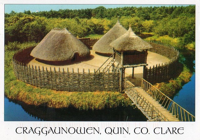
Craggaunowen Project, Quin, Co. Clare, Ireland
A lovely postcard I received from Ireland earlier this year.
Info from the back of the card:
16th century Craggaunowen Castle has been restored and now contains part of the Hunt Collection of medieval art objects. In the grounds of the castle is a reconstructed Crannog - a Bronze Age lake dwelling and a ring fort - a reconstruction of a farmer's house of the 4th century. Archaeological date from many sources were used in the reconstruction and furnishing of both projects.
Info from the back of the card:
16th century Craggaunowen Castle has been restored and now contains part of the Hunt Collection of medieval art objects. In the grounds of the castle is a reconstructed Crannog - a Bronze Age lake dwelling and a ring fort - a reconstruction of a farmer's house of the 4th century. Archaeological date from many sources were used in the reconstruction and furnishing of both projects.
Pilgrimage Church of Wies, Germany
Getting *really* behind with this blog again so time for an update. ...although I should probably be outside instead as it's such a gorgeous, sunny, warm day. Uh oh...
Today's first card is from the Unesco tag on the Postcrossing forum.
The Pilgrimage Church of Wies is an oval rococo church, designed in the late 1740s by Dominikus Zimmermann, who lived nearby for the last eleven years of his life. It is located in the foothills of the Alps, in the municipality of Steingaden in the Weilheim-Schongau district, Bavaria, Germany.
It is said that, in 1738, tears were seen on a dilapidated wooden figure of the Scourged Saviour. This miracle resulted in a pilgrimage rush to see the sculpture. In 1740, a small chapel was built to house the statue but it was soon realized that the building would be too small for the number of pilgrims it attracted, and so Steingaden Abbey decided to commission a separate shrine. Many who have prayed in front of the statue of Jesus on the altar have claimed that people have been miraculously cured of their diseases, which has made this church even more of a pilgrimage site.
Construction took place between 1745 and 1754, and the interior was decorated with frescoes and with stuccowork in the tradition of the Wessobrunner School. "Everything was done throughout the church to make the supernatural visible. Sculpture and murals combined to unleash the divine in visible form".
There is a popular belief that the Bavarian government planned to sell or demolish the rococo masterpiece during the secularization of Bavaria at the beginning of the 19th century, and that only protests from the local farmers saved it from destruction. Available sources, however, document that the responsible state commission clearly advocated the continuation of Wies as a pilgrimage site, even in spite of economic objections from the abbot of Steingaden.
The Wieskirche was added to the UNESCO World Heritage List in 1983 and underwent extensive restoration between 1985 and 1991.
Today's first card is from the Unesco tag on the Postcrossing forum.
The Pilgrimage Church of Wies is an oval rococo church, designed in the late 1740s by Dominikus Zimmermann, who lived nearby for the last eleven years of his life. It is located in the foothills of the Alps, in the municipality of Steingaden in the Weilheim-Schongau district, Bavaria, Germany.
It is said that, in 1738, tears were seen on a dilapidated wooden figure of the Scourged Saviour. This miracle resulted in a pilgrimage rush to see the sculpture. In 1740, a small chapel was built to house the statue but it was soon realized that the building would be too small for the number of pilgrims it attracted, and so Steingaden Abbey decided to commission a separate shrine. Many who have prayed in front of the statue of Jesus on the altar have claimed that people have been miraculously cured of their diseases, which has made this church even more of a pilgrimage site.
Construction took place between 1745 and 1754, and the interior was decorated with frescoes and with stuccowork in the tradition of the Wessobrunner School. "Everything was done throughout the church to make the supernatural visible. Sculpture and murals combined to unleash the divine in visible form".
There is a popular belief that the Bavarian government planned to sell or demolish the rococo masterpiece during the secularization of Bavaria at the beginning of the 19th century, and that only protests from the local farmers saved it from destruction. Available sources, however, document that the responsible state commission clearly advocated the continuation of Wies as a pilgrimage site, even in spite of economic objections from the abbot of Steingaden.
The Wieskirche was added to the UNESCO World Heritage List in 1983 and underwent extensive restoration between 1985 and 1991.
Subscribe to:
Posts (Atom)


Maroon