This is still one of my only Unesco postcards from Sweden. ...and it's got a lighthouse on it as well! :)
Högbonden is a Swedish island and lighthouse located in the World Heritage Site Höga kusten. From springtime in May through October a hostel is open to visitors in the old lightkeeper's house. In the summer season there is regular daily boat service from Bönhamn to Högbonden. The whole island is a nature reserve.
The lighthouse was built after complaints that there were no lighthouses between Lungö and Skagsudde. It is the second-highest placed lighthouse in Sweden (after Kullen Lighthouse), and it was also one of the most powerful. In November 2010 the old lens was finally retired and the power source changed to solar cell-power. The light now consists of a small white light on the balcony's railing and the red an green sectors was removed. As of 2012 the tower is in bad condition and in need of repairs. It is owned by the Swedish Maritime Administration.
Sunday, 1 February 2015
Svartifoss, Vatnajökull National Park, Iceland
Another swap card, this time from Iceland. The views there are stunning, I really hope to visit Iceland myself one day.
Svartifoss (Black Fall) is a waterfall in Skaftafell in Vatnajökull National Park in Iceland, and is one of the most popular sights in the park. It is surrounded by dark lava columns, which gave rise to its name. Other well-known columnar jointing formations are seen at the Giant's Causeway in Northern Ireland, Devil's Tower in Wyoming, USA and on the island of Staffa in Scotland. There are also similar formations throughout Iceland, including a small cave on the beach of Reynisdrangar.
The base of this waterfall is noteworthy for its sharp rocks. New hexagonal column sections break off faster than the falling water wears down the edges. These basalt columns have provided inspiration for Icelandic architects, most visibly in the Hallgrímskirkja church in Reykjavík, and also the National Theatre.
As of 2019, Vatnajökull National Park is a Unesco World Heritage Site. This iconic volcanic region covers an area of over 1,400,000 ha, nearly 14% of Iceland's territory. It numbers ten central volcanoes, eight of which are subglacial. Two of these are among the most active in Iceland. The interaction between volcanoes and the rifts that underlie the Vatnajökull ice cap takes many forms, the most spectacular of which is the jökulhlaup – a sudden flood caused by the breach of the margin of a glacier during an eruption. This recurrent phenomenon has led to the emergence of unique sandur plains, river systems and rapidly evolving canyons. Volcanic areas are home to endemic groundwater fauna that has survived the Ice Age.
Svartifoss (Black Fall) is a waterfall in Skaftafell in Vatnajökull National Park in Iceland, and is one of the most popular sights in the park. It is surrounded by dark lava columns, which gave rise to its name. Other well-known columnar jointing formations are seen at the Giant's Causeway in Northern Ireland, Devil's Tower in Wyoming, USA and on the island of Staffa in Scotland. There are also similar formations throughout Iceland, including a small cave on the beach of Reynisdrangar.
The base of this waterfall is noteworthy for its sharp rocks. New hexagonal column sections break off faster than the falling water wears down the edges. These basalt columns have provided inspiration for Icelandic architects, most visibly in the Hallgrímskirkja church in Reykjavík, and also the National Theatre.
As of 2019, Vatnajökull National Park is a Unesco World Heritage Site. This iconic volcanic region covers an area of over 1,400,000 ha, nearly 14% of Iceland's territory. It numbers ten central volcanoes, eight of which are subglacial. Two of these are among the most active in Iceland. The interaction between volcanoes and the rifts that underlie the Vatnajökull ice cap takes many forms, the most spectacular of which is the jökulhlaup – a sudden flood caused by the breach of the margin of a glacier during an eruption. This recurrent phenomenon has led to the emergence of unique sandur plains, river systems and rapidly evolving canyons. Volcanic areas are home to endemic groundwater fauna that has survived the Ice Age.
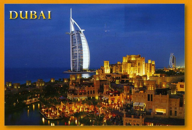
Madinat Jumeirah and Burj Al Arab, Dubai
I was supposed to go to an Aikido class in Birmingham this morning with Matt, but he's not feeling too well and I'm not exactly feeling too great either - I hope I haven't caught the cold as well. :/ Anyway, I thought I'd post a few cards here instead. The first one is from a swap a few years ago, and still one of my only postcards from Dubai.
Madinat Jumeirah the Arabian Resort - Dubai, is a luxurious 5 star resort in Dubai and is also the largest resort in the emirate, spreading across over 40 hectares of landscapes and gardens. It is designed to resemble a traditional Arabian town. The resort comprises two boutique hotels (Al Qasr and Mina A'Salam) and a courtyard of 29 summer houses called Dar Al Masyaf. The resort has over 40 restaurants and bars.
Madinat Jumeirah is located along one kilometre of private beachfront adjacent to Jumeirah Beach Hotel, Burj Al Arab, and Wild Wadi Water Park. It is an approximate 30 minute drive from Dubai International Airport in non-peak traffic.
Madinat Jumeirah the Arabian Resort - Dubai, is a luxurious 5 star resort in Dubai and is also the largest resort in the emirate, spreading across over 40 hectares of landscapes and gardens. It is designed to resemble a traditional Arabian town. The resort comprises two boutique hotels (Al Qasr and Mina A'Salam) and a courtyard of 29 summer houses called Dar Al Masyaf. The resort has over 40 restaurants and bars.
Madinat Jumeirah is located along one kilometre of private beachfront adjacent to Jumeirah Beach Hotel, Burj Al Arab, and Wild Wadi Water Park. It is an approximate 30 minute drive from Dubai International Airport in non-peak traffic.
Saturday, 17 January 2015
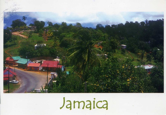
Walker's Wood, St. Ann, Jamaica
One more card for today. This one's from 2012, received through the 'Vacation RR' on the Postcrossing forum. I rarely manage to get into the groups these days (and I do wonder sometimes how people do it as it always seems to be the same people getting into the groups O_o) but I was lucky back then. Anyway, I really like this view.
The village of Walker's Wood is located in Saint Ann, the largest parish in Jamaica. It is situated on the north coast of the island, in the county of Middlesex, roughly halfway between the eastern and western ends of the island. It is often called 'the Garden Parish of Jamaica' on account of its natural beauty. Saint Ann is the birthplace of reggae singers Floyd Lloyd, Burning Spear, Shabba Ranks, and Bob Marley. The Right Excellent Marcus Mosiah Garvey, one of Jamaica's seven National Heroes, was also born there. More recently, it has become known as the headquarters of the Jamaica Dogsled Team.
Mingun Bell, Myanmar
...and one more card from a swap in 2013. :D
The Mingun Bell is a bell located in Mingun, Sagaing Region, Myanmar. It is located approximately 11 km north of Mandalay on the western bank of the Irrawaddy River. It was the heaviest functioning bell in the world at several times in history.
Bishkek, Kyrgyzstan
I only just realised that most of the postcards I picked for today were received in 2013. That certainly wasn't intentional, it just happened. Hmmm... Anyway, here's another swap card from 2013, this time from Kyrgyzstan.
Bishkek, formerly Pishpek and Frunze, is the capital and the largest city in the Central Asian country of Kyrgyzstan. Bishkek is also the administrative centre of Chuy Province which surrounds the city, even though the city itself is not part of the province but rather a province-level unit of Kyrgyzstan.
Bishkek is situated at about 800 metres altitude just off the northern fringe of the Kyrgyz Ala-Too range, an extension of the Tian Shan mountain range, which rises up to 4,855 metres and provides a spectacular backdrop to the city. North of the city, a fertile and gently undulating steppe extends far north into neighbouring Kazakhstan. The Chui River drains most of the area. Bishkek is connected to the Turkestan-Siberia Railway by a spur line.
Bishkek is a city of wide boulevards and marble-faced public buildings combined with numerous Soviet-style apartment blocks surrounding interior courtyards and, especially outside the city centre, thousands of smaller privately built houses. It is laid out on a grid pattern, with most streets flanked on both sides by narrow irrigation channels that water the innumerable trees which provide shade in the hot summers.
Bishkek, formerly Pishpek and Frunze, is the capital and the largest city in the Central Asian country of Kyrgyzstan. Bishkek is also the administrative centre of Chuy Province which surrounds the city, even though the city itself is not part of the province but rather a province-level unit of Kyrgyzstan.
Bishkek is situated at about 800 metres altitude just off the northern fringe of the Kyrgyz Ala-Too range, an extension of the Tian Shan mountain range, which rises up to 4,855 metres and provides a spectacular backdrop to the city. North of the city, a fertile and gently undulating steppe extends far north into neighbouring Kazakhstan. The Chui River drains most of the area. Bishkek is connected to the Turkestan-Siberia Railway by a spur line.
Bishkek is a city of wide boulevards and marble-faced public buildings combined with numerous Soviet-style apartment blocks surrounding interior courtyards and, especially outside the city centre, thousands of smaller privately built houses. It is laid out on a grid pattern, with most streets flanked on both sides by narrow irrigation channels that water the innumerable trees which provide shade in the hot summers.
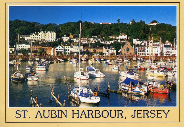
Saint Aubin harbour, Jersey
This is still one of my only written and stamped postcards from Jersey...
Saint Aubin is a port in the Channel Island of Jersey. It opens out to a bay of the Gulf of Saint-Malo.
Originally a fishing village located on the west side of Saint Aubin's Bay opposing St Helier to the east, St Aubin is the hub of the parish of St Brelade. Its name refers to Saint Aubin the 6th Century C.E. bishop of Angers, and may reflect the name of a long-disappeared chapel.
The parish hall is housed in the former railway station. The Railway Walk, a trail following the route of the former railway to La Corbière, starts from St Aubin.
Saint Aubin's Fort lies in the bay on a tidal island, just outside the harbour. This fort is accessible on foot, at a low tide, via a causeway that runs from the road just in front of the Royal Channel Islands Yacht Club. The fort features a tower keep that is surrounded by granite walls and ramparts. During the Occupation of the Channel Islands, the German forces added bunkers and other features to the fort.
Saint Aubin is a port in the Channel Island of Jersey. It opens out to a bay of the Gulf of Saint-Malo.
Originally a fishing village located on the west side of Saint Aubin's Bay opposing St Helier to the east, St Aubin is the hub of the parish of St Brelade. Its name refers to Saint Aubin the 6th Century C.E. bishop of Angers, and may reflect the name of a long-disappeared chapel.
The parish hall is housed in the former railway station. The Railway Walk, a trail following the route of the former railway to La Corbière, starts from St Aubin.
Saint Aubin's Fort lies in the bay on a tidal island, just outside the harbour. This fort is accessible on foot, at a low tide, via a causeway that runs from the road just in front of the Royal Channel Islands Yacht Club. The fort features a tower keep that is surrounded by granite walls and ramparts. During the Occupation of the Channel Islands, the German forces added bunkers and other features to the fort.
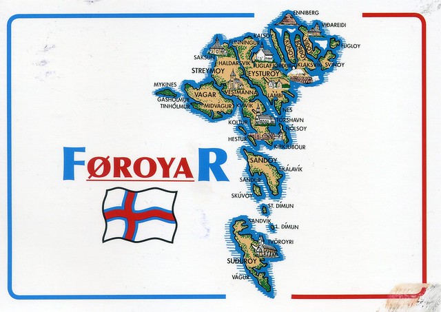
A wonderful map card I received from dear Johanna in Finland just over a year ago. This card was mailed from Finland but Johanna has actually been to the Faroe Islands - and sent me a postcard, which I blogged about here.
The Faroe Islands is an archipelago and autonomous country within the Kingdom of Denmark, situated between the Norwegian Sea and the North Atlantic Ocean, approximately halfway between Norway and Iceland, at about 320 kilometres north-north-west of mainland Scotland. The total area is approximately 1,400 km2 with a 2010 population of almost 50,000 people.
The Faroe Islands have been a self-governing country within the Danish Realm since 1948. Over the years, the Faroese have taken control of most domestic matters. Areas that remain the responsibility of Denmark include military defence, police, justice, currency and foreign affairs. The Faroe Islands also have representatives in the Nordic Council as members of the Danish delegation.
The islands were associated with and taxed by Norway, then the Union of Kalmar, and then Denmark–Norway until 1814, when Norway was united with Sweden. Scandinavia was in political turmoil following the Sixth Coalition of the Napoleonic Wars, when the Treaty of Kiel granted Denmark control over the Faroes, Iceland and Greenland in 1814. The Danish trade monopoly ended in 1856.
The Faroe Islands is an archipelago and autonomous country within the Kingdom of Denmark, situated between the Norwegian Sea and the North Atlantic Ocean, approximately halfway between Norway and Iceland, at about 320 kilometres north-north-west of mainland Scotland. The total area is approximately 1,400 km2 with a 2010 population of almost 50,000 people.
The Faroe Islands have been a self-governing country within the Danish Realm since 1948. Over the years, the Faroese have taken control of most domestic matters. Areas that remain the responsibility of Denmark include military defence, police, justice, currency and foreign affairs. The Faroe Islands also have representatives in the Nordic Council as members of the Danish delegation.
The islands were associated with and taxed by Norway, then the Union of Kalmar, and then Denmark–Norway until 1814, when Norway was united with Sweden. Scandinavia was in political turmoil following the Sixth Coalition of the Napoleonic Wars, when the Treaty of Kiel granted Denmark control over the Faroes, Iceland and Greenland in 1814. The Danish trade monopoly ended in 1856.
Eyeries, Ireland
Happy New Year 2015! Mine has started pretty well postcard-wise and hopefully will continue that way.
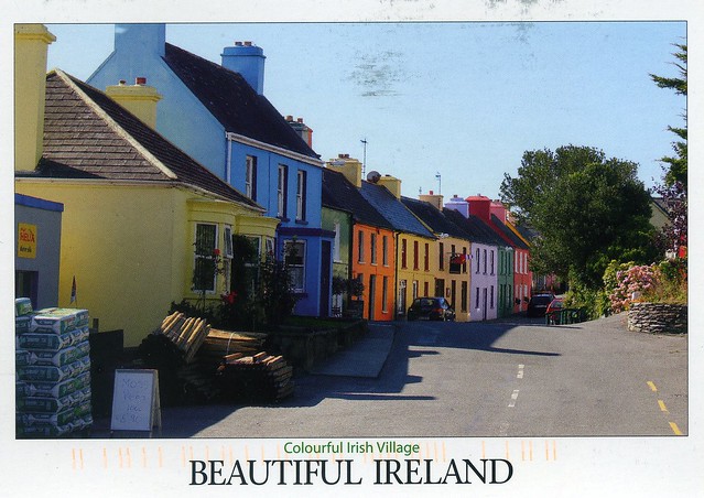
Today's first card isn't one of the most recent ones I've received, though, but one from a swap a little over a year ago. I just love the colours here!
Eyeries is a village and townland on the Beara Peninsula in County Cork, Ireland overlooking Coulagh Bay and the mouth of the Kenmare River in the south-west. It lies at the base of Maulin, which, at 623 m, is the highest peak in the Slieve Miskish mountain range that forms part of the backbone of the peninsula. Eyeries was the location for the shooting of the film The Purple Taxi (1977) starring Fred Astaire, Peter Ustinov, and Charlotte Rampling, and also the 1998 TV series Falling for a Dancer, a dramatisation of life and love in 1930s Ireland based on the novel by Deirdre Purcell.
Eyeries has three pubs, a shop/restaurant and a post office (according to the information on the back of the card).
Today's first card isn't one of the most recent ones I've received, though, but one from a swap a little over a year ago. I just love the colours here!
Eyeries is a village and townland on the Beara Peninsula in County Cork, Ireland overlooking Coulagh Bay and the mouth of the Kenmare River in the south-west. It lies at the base of Maulin, which, at 623 m, is the highest peak in the Slieve Miskish mountain range that forms part of the backbone of the peninsula. Eyeries was the location for the shooting of the film The Purple Taxi (1977) starring Fred Astaire, Peter Ustinov, and Charlotte Rampling, and also the 1998 TV series Falling for a Dancer, a dramatisation of life and love in 1930s Ireland based on the novel by Deirdre Purcell.
Eyeries has three pubs, a shop/restaurant and a post office (according to the information on the back of the card).
Wednesday, 24 December 2014
Bulguksa Temple, South Korea
Merry Christmas to everyone who celebrates it! I hope you'll all have a wonderful holiday season. Personally I'm hoping to get some sleep... Last night I managed to sleep for maybe two hours in total as my body clock is still a bit messed up from all the night shifts I've been doing, so I'm a bit tired now.. -_-
Anyway, just one postcard for today. There's no snow here in England at the moment, thank goodness, but I thought this would be appropriate for today and sort of Christmassy.
Bulguksa is located on the slopes of mount Toham (Jinheon-dong, Gyeongju city, North Gyeongsang province, South Korea). It is a head temple of the Jogye Order of Korean Buddhism and encompasses seven National treasures of South Korea, including Dabotap and Seokgatap stone pagodas, Cheongun-gyo (Blue Cloud Bridge), and two gilt-bronze statues of Buddha. The temple is classified as Historic and Scenic Site No. 1 by the South Korean government. In 1995, Bulguksa was added to the UNESCO World Heritage List together with the Seokguram Grotto, which lies four kilometers to the east.
The temple is considered as a masterpiece of the golden age of Buddhist art in the Silla kingdom. It is currently the head temple of the 11th district of the Jogye Order of Korean Buddhism.
Anyway, just one postcard for today. There's no snow here in England at the moment, thank goodness, but I thought this would be appropriate for today and sort of Christmassy.
Bulguksa is located on the slopes of mount Toham (Jinheon-dong, Gyeongju city, North Gyeongsang province, South Korea). It is a head temple of the Jogye Order of Korean Buddhism and encompasses seven National treasures of South Korea, including Dabotap and Seokgatap stone pagodas, Cheongun-gyo (Blue Cloud Bridge), and two gilt-bronze statues of Buddha. The temple is classified as Historic and Scenic Site No. 1 by the South Korean government. In 1995, Bulguksa was added to the UNESCO World Heritage List together with the Seokguram Grotto, which lies four kilometers to the east.
The temple is considered as a masterpiece of the golden age of Buddhist art in the Silla kingdom. It is currently the head temple of the 11th district of the Jogye Order of Korean Buddhism.
Sunday, 21 December 2014
Sandy Ground, Anguilla
One more card for today... and another new country to my collection! I've said this before but I wouldn't mind being somewhere like this at the moment... Warmth, the sun...
Anguilla is a British overseas territory in the Caribbean. It is one of the most northerly of the Leeward Islands in the Lesser Antilles, lying east of Puerto Rico and the Virgin Islands and directly north of Saint Martin. The territory consists of the main island of Anguilla itself, approximately 26 km long by 5 km wide at its widest point, together with a number of much smaller islands and cays with no permanent population. The island's capital is The Valley. The total land area of the territory is 90 km2, with a population of approximately 13,500 (2006 estimate).
Anguilla has become a popular tax haven, having no capital gains, estate, profit or other forms of direct taxation on either individuals or corporations. In April 2011, faced with a mounting deficit, it introduced a 3% "Interim Stabilisation Levy", Anguilla's first form of income tax.
Anguilla is a flat, low-lying island of coral and limestone in the Caribbean Sea, east of Puerto Rico and the Virgin Islands. It is directly north of Saint Martin, separated from that island by the Anguilla Channel. The soil is generally thin and poor, supporting scrub tropical and forest vegetation. Anguilla is noted for its spectacular and ecologically important coral reefs and beaches.
Anguilla is a British overseas territory in the Caribbean. It is one of the most northerly of the Leeward Islands in the Lesser Antilles, lying east of Puerto Rico and the Virgin Islands and directly north of Saint Martin. The territory consists of the main island of Anguilla itself, approximately 26 km long by 5 km wide at its widest point, together with a number of much smaller islands and cays with no permanent population. The island's capital is The Valley. The total land area of the territory is 90 km2, with a population of approximately 13,500 (2006 estimate).
Anguilla has become a popular tax haven, having no capital gains, estate, profit or other forms of direct taxation on either individuals or corporations. In April 2011, faced with a mounting deficit, it introduced a 3% "Interim Stabilisation Levy", Anguilla's first form of income tax.
Anguilla is a flat, low-lying island of coral and limestone in the Caribbean Sea, east of Puerto Rico and the Virgin Islands. It is directly north of Saint Martin, separated from that island by the Anguilla Channel. The soil is generally thin and poor, supporting scrub tropical and forest vegetation. Anguilla is noted for its spectacular and ecologically important coral reefs and beaches.
Nunavut, Canada
A lovely card from back in 2009. Alas, this wasn't mailed from Canada but I don't really mind too much when the card is this beautiful and I had had it in my favourites for a while.
Clockwise from top left: The Inuksuk, Purple Saxifrage, Canadian Inuit Dog, The Rock Ptarmigan.
Nunavut is the largest, northernmost and newest territory of Canada. It was separated officially from the Northwest Territories on April 1, 1999, via the Nunavut Act and the Nunavut Land Claims Agreement Act, though the boundaries had been contemplatively drawn in 1993. The creation of Nunavut resulted in the first major change to Canada's political map since the incorporation of the new province of Newfoundland and Labrador in 1949.
Nunavut comprises a major portion of Northern Canada, and most of the Canadian Arctic Archipelago. Its vast territory makes it the fifth-largest country subdivision in the world, as well as the second-largest in North America after Greenland. The capital Iqaluit (formerly "Frobisher Bay") on Baffin Island, in the east, was chosen by the 1995 capital plebiscite. Other major communities include the regional centres of Rankin Inlet and Cambridge Bay. Nunavut also includes Ellesmere Island to the far north, as well as the eastern and southern portions of Victoria Island in the west and Akimiski Island in James Bay to the far south. It is the only geo-political region of Canada that is not connected to the rest of North America by highway.
Nunavut is both the least populous and the largest in area of the provinces and territories of Canada. One of the most remote, sparsely settled regions in the world, it has a population of 31,906, mostly Inuit, spread over a land area the size of Western Europe. Nunavut is also home to the northernmost permanently inhabited place in the world, Alert. A weather station farther down Ellesmere Island, Eureka, has the lowest average annual temperature of any weather station in Canada.
Clockwise from top left: The Inuksuk, Purple Saxifrage, Canadian Inuit Dog, The Rock Ptarmigan.
Nunavut is the largest, northernmost and newest territory of Canada. It was separated officially from the Northwest Territories on April 1, 1999, via the Nunavut Act and the Nunavut Land Claims Agreement Act, though the boundaries had been contemplatively drawn in 1993. The creation of Nunavut resulted in the first major change to Canada's political map since the incorporation of the new province of Newfoundland and Labrador in 1949.
Nunavut comprises a major portion of Northern Canada, and most of the Canadian Arctic Archipelago. Its vast territory makes it the fifth-largest country subdivision in the world, as well as the second-largest in North America after Greenland. The capital Iqaluit (formerly "Frobisher Bay") on Baffin Island, in the east, was chosen by the 1995 capital plebiscite. Other major communities include the regional centres of Rankin Inlet and Cambridge Bay. Nunavut also includes Ellesmere Island to the far north, as well as the eastern and southern portions of Victoria Island in the west and Akimiski Island in James Bay to the far south. It is the only geo-political region of Canada that is not connected to the rest of North America by highway.
Nunavut is both the least populous and the largest in area of the provinces and territories of Canada. One of the most remote, sparsely settled regions in the world, it has a population of 31,906, mostly Inuit, spread over a land area the size of Western Europe. Nunavut is also home to the northernmost permanently inhabited place in the world, Alert. A weather station farther down Ellesmere Island, Eureka, has the lowest average annual temperature of any weather station in Canada.
Subscribe to:
Posts (Atom)


Maroon