Sunday, 12 January 2014

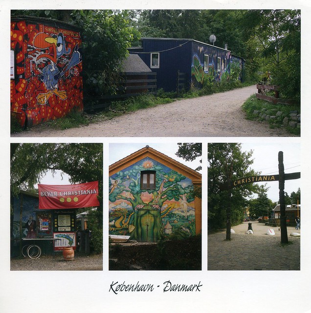
Christiania, Copenhagen, Denmark

It's been a quiet day so I thought I'd try to catch up on this blog a bit again :P Today's first card is from a swap with Chris in Denmark, I received some truly gorgeous postcards from him last year!


Christiania, also known as Freetown Christiania (Danish: Fristaden Christiania) is a self-proclaimed autonomous neighbourhood of about 850 residents, covering 34 hectares in the borough of Christianshavn in the Danish capital Copenhagen. Civic authorities in Copenhagen regard Christiania as a large commune, but the area has a unique status in that it is regulated by a special law, the Christiania Law of 1989 which transfers parts of the supervision of the area from the municipality of Copenhagen to the state. It was closed by residents in April 2011, whilst discussions continued with the Danish government as to its future, but is now open again. Christiania has been a source of controversy since its creation in a squatted military area in 1971. Its cannabis trade was tolerated by authorities until 2004. Since then, measures for normalising the legal status of the community have led to conflicts, police raids and negotiations which are ongoing.

Chris told me that postcards of Christiania are rare as they don't normally allow photography in the area.

Saturday, 11 January 2014

Tortola, British Virgin Islands

One more card for today... and from such a fascinating place as well! Pat of the US kindly offered to swap with me and sent me this treat (it did take a while to reach England, but I received it eventually). Mmmmm, I'd really like to be somewhere warm and sunny at the moment, too, I'm not a huge fan of English winters. :P


Tortola is the largest and most populated of the British Virgin Islands, a group of islands that form part of the archipelago of the Virgin Islands. Local tradition recounts that Christopher Columbus named it Tortola, meaning "land of the Turtle Dove". Columbus named the island Santa Ana. The later Dutch settled and called it Ter Tholen, after a coastal island forming part of the west coast of the Netherlands. When the British took over, they altered the name to its present-day Tortola. The population of Tortola is 23,908. The principal settlement is Road Town, the capital of the British Virgin Islands.

The British Virgin Islands, then, is a British overseas territory located in the Caribbean to the east of Puerto Rico. The islands make up part of the Virgin Islands archipelago, the remaining islands constitute the US Virgin Islands and the Spanish Virgin Islands.

The official name of the Territory is still simply the "Virgin Islands", but the prefix "British" is often used to distinguish it from the neighbouring American territory which changed its name from the "Danish West Indies" to "Virgin Islands of the United States" in 1917. British Virgin Islands government publications continue to begin with the name "The Territory of the Virgin Islands", and the Territory's passports simply refer to the "Virgin Islands", and all laws begin with the words "Virgin Islands".

The British Virgin Islands consist of the main islands of Tortola, Virgin Gorda, Anegada, and Jost Van Dyke, along with over fifty other smaller islands and cays. About 15 of the islands are inhabited. The islands have a population of about 27,800.

British Virgin Islanders are classed as British Overseas Territories citizens and since 2002 have had full British citizenship. Although the territory is not part of the European Union and not directly subject to EU law, its citizens are deemed to be citizens of the EU as well.

Iraq

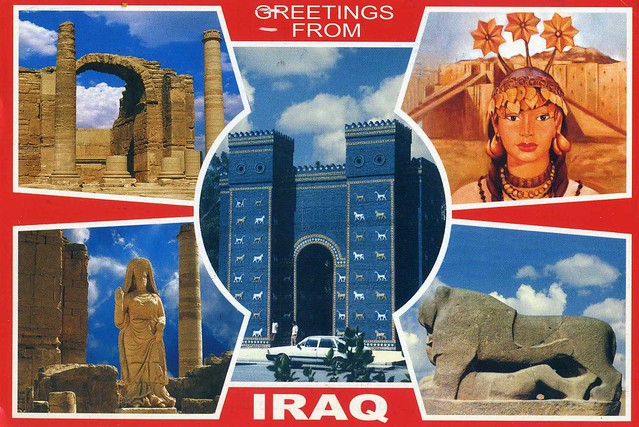
This is another postcard from the swap I had with Milad in Iraq back in 2010. I've posted about the other card in this blog before. These two cards are still my only ones from Iraq.


There is some writing on the back of the card but it's all in Arabic so I have no idea whether it says something about the places on this card. ..and as a result I'm totally clueless here. Well, not completely - the picture in the bottom left corner looks like it's from Hatra, which also happens to be a Unesco site. :) A large fortified city under the influence of the Parthian Empire and capital of the first Arab Kingdom, Hatra withstood invasions by the Romans in A.D. 116 and 198 thanks to its high, thick walls reinforced by towers. The remains of the city, especially the temples where Hellenistic and Roman architecture blend with Eastern decorative features, attest to the greatness of its civilization.

Milad wrote that Iraq is the cradle of ancient empires and civilizations dated back to 6000 years. I find this really fascinating, and the more recent history of the region very sad. Hopefully things will improve there.

Sapporo Snow Festival, Japan

Another snowy view, this time from Japan.


The Sapporo Snow Festival is a festival held annually in Sapporo, Japan, over seven days in February. Odori Park, Susukino, and Tsudome are the main sites of the festival. The 2014 Snow Festival dates are 5 to 11 February.

The festival is one of Japan's largest and most distinctive winter events. In 2007 (58th Festival), about two million people visited Sapporo to see the hundreds of snow statues and ice sculptures at the Odori Park and Susukino sites, in central Sapporo, and at the Satoland site. An International Snow Sculpture Contest has been held at the Odori Park site since 1974, and 14 teams from various regions of the world participated in 2008. The subject of the statues varies and often features an event, famous building or person from the previous year.

The Snow Festival began in 1950, when six local high school students built six snow statues in Odori Park. In 1955, the Japan Self-Defense Forces from the nearby Makomanai base joined in and built the first massive snow sculptures, for which the Snow Festival has now become famous. Several snow festivals existed in Sapporo prior to the Sapporo Snow Festival, however, all of these were suspended during World War II.

Åland

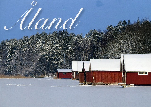
A lovely snowy view of Åland I received from a swap last year.


I have no idea where exactly in Åland this place is, there is no information on the card. It does look like it's a seashore, though - those houses/sheds look so much like the ones in the Astrid Lindgren's 'Vi på Saltkråkan' tv series that I used to love when I was a kid (well, I still really like it and wouldn't mind having it on dvd). If you want to read more about the series, check Wikipedia. There might be some clips on youtube as well, I haven't checked though and they would most likely be in Swedish... Speaking of snow, we haven't actually had ANY over here so far this winter! I don't mind in the least as everything always turns into chaos when it snows here. :P Still, it does look pretty.

Røros Mining Town, Norway

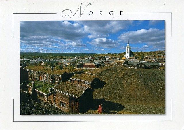
Ok, I'll try to finish the update I started yesterday. :P ...starting off with this gorgeous Norwegian Unesco card that was one of the cards I received as part of the 'winner of the month' lottery in September last year. It's always such a pleasure to receive postcards from Cathrine, she's so thoughtful and I love it how her cards are so full of writing, too :)


Røros Mining Town and the Circumference is linked to the copper mines, established in the 17th century and exploited for 333 years until 1977. The site comprises the Town and its industrial-rural cultural landscapes; Femundshytta, a smelter with its associated area; and the Winter Transport Route. Completely rebuilt after its destruction by Swedish troops in 1679, Røros contains about 2000 wooden one- and two-storey houses and a smelting house. Many of these buildings have preserved their blackened wooden façades, giving the town a medieval appearance. Surrounded by a buffer zone, coincident with the area of privileges (the Circumference) granted to the mining enterprise by the Danish-Norwegian Crown (1646), the property illustrates the establishment and flourishing of a lasting culture based on copper mining in a remote region with a harsh climate.

Friday, 10 January 2014

Carraig Fhada Lighthouse, Islay, Scotland

Another postcard I received last year, this one is from my Finnish penpal Keiju, sent from her holidays in Scotland. She got to visit some amazing places - how lovely would it be to visit some of these more remote parts of Scotland?!?


Carraig Fhada Lighthouse is located at Port Ellen, a small town on the island of Islay, in Argyll, Scotland. Islay, then, is the southernmost island of the Inner Hebrides of Scotland. Known as "The Queen of the Hebrides", it lies in Argyll just south west of Jura and around 40 kilometres north of the Irish coast. The island's capital and largest settlement is Bowmore where the distinctive round Kilarrow Parish Church and a distillery are located. Port Ellen is the main port.

Islay is the fifth-largest Scottish island and the seventh-largest island surrounding Great Britain, with a total area of almost 620 square kilometres. There is ample evidence of the prehistoric settlement of Islay and the first written reference may have come in the 1st century AD. The island had become part of the Gaelic Kingdom of Dál Riata during the Early Middle Ages before being absorbed into the Norse Kingdom of the Isles. The later medieval period marked a "cultural high point" with the transfer of the Hebrides to the Kingdom of Scotland and the emergence of the Clan Donald Lordship of the Isles, originally centred at Finlaggan. During the 17th century the Clan Donald star waned, but improvements to agriculture and transport led to a rising population, which peaked in the mid-19th century. This was followed by substantial forced displacements and declining resident numbers.

Today, it has over 3,000 inhabitants and the main commercial activities are agriculture, malt whisky distillation and tourism. The island has a long history of religious observance and Scottish Gaelic is spoken by about a quarter of the population. Its landscapes have been celebrated through various art forms and there is a growing interest in renewable energy. Islay is home to many bird species such as the wintering populations of Greenland White-fronted and Barnacle Goose, and is a popular destination throughout the year for birdwatchers. The climate is mild and ameliorated by the Gulf Stream.

I have to confess I pretty much only recognised the name 'Islay' before because of whisky - my dad really likes whisky and I recognise some of the names on the bottles (Laphroaig and Ardbeg mostly). Islay is one of five whisky distilling localities and regions in Scotland whose identity is protected by law. There are eight active distilleries and the industry is the island's second largest employer after agriculture. Those on the south of the island produce malts with a very strong peaty flavour, considered to be the most intensely flavoured of all whiskies. From east to west they are Ardbeg, Lagavulin, and Laphroaig. On the north of the island Bowmore, Bruichladdich, Caol Ila and Bunnahabhain are produced, which are substantially lighter in taste. Kilchoman is a microdistillery opened in 2005 toward the west coast of the Rinns. The oldest record of a legal distillery on the island refers to Bowmore in 1779 and at one time there were up to 23 distilleries in operation.


You don't need to pay this much to send a postcard within the UK... I'm guessing Keiju didn't realise this, I just feel bad that she ended up overpaying to send my card.

New Zealand

Happy new year 2014! I'm really hoping this year will be better than the last one, it feels like I pretty much wasted 2013... I did just write to someone on the Postcrossing forum that I'm going to have to cut back on the number of postcards I send this year, again, as stamps are so expensive (and I'm dreading the annual price increase sometime during the spring, I hope the Royal Mail won't copy countries like Australia, Canada or Finland...) but I'm still going to be sending postcards, even if I'll have to be more careful. This year hasn't started off too badly actually, I've already received some great cards (and one from a new country as well, I'm hoping to post about that one at some point).

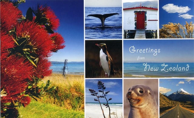
Anyway. I was going to make a longer post and already picked the cards I wanted to post about, but it's getting late so I'll just do a couple now and maybe (MAYBE) finish at some point this weekend. This first card is yet another swap with Aaron from New Zealand, I really like his postcards!


I've said before that I'm not generally too fond of multiviews but the ones I've received from New Zealand always seem to be really nice. ...is it because I just find the country so fascinating?? :P There isn't much information about the places on this card, at the back it only says that the flowers are the native pohutukawa or New Zealand christmas tree.


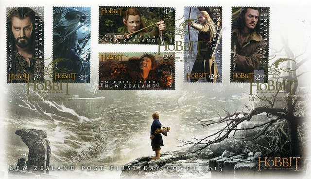
To be honest, the main reason for my picking this particular card was the stamp Aaron chose - I'm pretty obsessed with 'The Hobbit' at the moment. *blushes* This stamp is from a set of six stamps issued last year, I actually ordered the first day cover (and the maxi cards... *cough cough*) from the New Zealand Post website. Here it is:

I'm a little disappointed that it arrived in a separate envelope and they didn't print my name and address on it (the way the Royal Mail do their first day covers) but other than that I just love it!

Saturday, 14 December 2013

Afghanistan

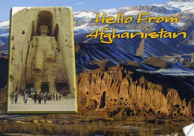
Yeah, just a couple of cards again for today. This one's pretty special as well, my first postcard from Afghanistan, although not mailed using Afghan stamps but mailed from a US army base. Still, I'm really happy to have this one in my collection, and it's a Unesco card as well! :) Thank you so much for the swap, Jon!


Afghanistan, officially the Islamic Republic of Afghanistan, is a landlocked sovereign state forming part of South Asia, Central Asia, and to some extent Western Asia. It has a population of around 30 million inhabiting an area of approximately 647,500 km2, making it the 42nd most populous and 41st largest nation in the world. It is bordered by Pakistan in the south and the east, Iran in the west, Turkmenistan, Uzbekistan, and Tajikistan in the north, and China in the far northeast.

Afghanistan has been an ancient focal point of the Silk Road and human migration. Archaeologists have found evidence of human habitation from as far back as the Middle Paleolithic. Urban civilization may have begun in the area as early as 3,000 to 2,000 BC. Sitting at an important geostrategic location that connects the Middle East culture with Central Asia and the Indian subcontinent, the land has been home to various peoples through the ages and witnessed many military campaigns, notably by Alexander the Great, Arab Muslims, Genghis Khan, and in modern era Western forces. The land also served as a source from which the Kushans, Hephthalites, Samanids, Ghaznavids, Ghorids, Mughals, Durranis and others have risen to form major empires.

The political history of the modern state of Afghanistan begins in 1709 with the rise of the Pashtuns, when the Hotaki dynasty was established in Kandahar followed by the rise of the Durrani Empire in 1747. In the late 19th century, Afghanistan became a buffer state in the "Great Game" between British India and the Russian Empire. Following the 1919 Anglo-Afghan War, King Amanullah began a European style modernization of the country but was stopped by ultra-conservatives. During the Cold War, after the withdrawal of the British from neighboring India in 1947, the United States and the Soviet Union began spreading influences in Afghanistan, which led in 1979 to a bloody war between the US-backed mujahideen forces and the Soviet-backed Afghan government in which over a million Afghans lost their lives. This was followed by a 1990s civil war, the rise and fall of the extremist Taliban government, and the 2001–present war. In December 2001, the United Nations Security Council authorized the creation of the International Security Assistance Force (ISAF) to help maintain security in Afghanistan and assist the Karzai administration.

 Three decades of war made Afghanistan one of the world's most dangerous countries. While the international community is rebuilding war-torn Afghanistan, terrorist groups such as the Haqqani Network and Hezbi Islami are actively involved in a nationwide Taliban-led insurgency, which includes hundreds of assassinations and suicide attacks. According to the United Nations, the insurgents were responsible for 80% of civilian casualties in 2011 and 2012.

As for this postcard, it shows the Cultural Landscape and Archaeological Remains of the Bamiyan Valley. Ignoring an international outcry, the Taliban began demolishing statues across the country in 2001, including two towering ancient stone Buddhas. Militiamen virtually destroyed the almost 2,000-year-old Buddhist masterpieces in the central province of Bamiyan, including the world's tallest standing Buddha measuring 50 metres.
Bulgaria

Time for another wee post, long overdue again. Oops.. I received this beautiful card from dear Snježana earlier this year from her holiday in Bulgaria. It must be lovely there!


Bulgaria, officially the Republic of Bulgaria, is a country located in Southeastern Europe. It is bordered by Romania to the north, Serbia and Macedonia to the west, Greece and Turkey to the south, and the Black Sea to the east. With a territory of 110,994 square kilometres, Bulgaria is Europe's 14th-largest country.

Organised Prehistoric cultures began developing on Bulgarian lands during the Neolithic period. Its ancient history saw the presence of the Thracians, and later the Greeks and Romans. The emergence of a unified Bulgarian state dates back to the establishment of the First Bulgarian Empire in 681 CE, which dominated most of the Balkans and functioned as a cultural hub for Slavic peoples during the Middle Ages. With the downfall of the Second Bulgarian Empire in 1396, its territories came under Ottoman rule for nearly five centuries. The Russo-Turkish War of 1877–1878 led to the formation of the Third Bulgarian State. The following years saw several conflicts with its neighbours, which prompted Bulgaria to align with Germany in both World Wars. In 1946 it became a single-party Socialist state as part of the Soviet-led Eastern Bloc. In 1989 the ruling Communist Party allowed multi-party elections, which subsequently led to Bulgaria's transition into a democracy and a market-based economy.

Bulgaria's population of 7.36 million people is predominantly urbanised and mainly concentrated in the administrative centres of its 28 provinces. Most commercial and cultural activities are centered on the capital and largest city, Sofia. The strongest sectors of the economy are heavy industry, power engineering, and agriculture, all of which rely on local natural resources.

Monday, 11 November 2013

Benin

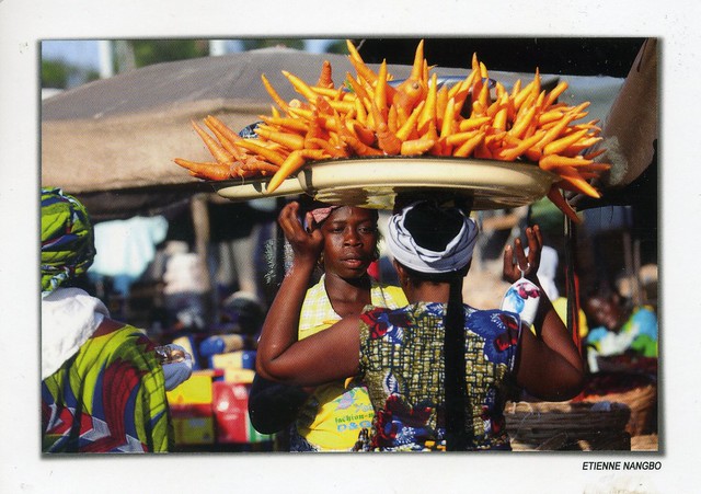
The second and last card for today :P It's a new country to my collection as well, and one of the few postcards I have from Africa. Thank you a million, Johanna! I love markets views as well so this card is pretty much perfect :)


Benin is a country in West Africa. It is bordered by Togo to the west, by Nigeria to the east and by Burkina Faso and Niger to the north. A majority of the population live on its small southern coastline on the Bight of Benin. The capital of Benin is Porto-Novo, but the seat of government is in Cotonou, the country's largest city. Benin covers an area of approximately 110,000 square kilometers, with a population of approximately 9.05 million. Benin is a tropical, sub-Saharan nation, highly dependent on agriculture, with substantial employment and income arising from subsistence farming.

The official language of Benin is French. However, indigenous languages such as Fon and Yoruba are commonly spoken. The largest religious group in Benin is Roman Catholicism, followed closely by Islam, Vodun and Protestantism. Benin is a member of the United Nations, the African Union, the Organisation of Islamic Cooperation, South Atlantic Peace and Cooperation Zone, La Francophonie, the Community of Sahel-Saharan States, the African Petroleum Producers Association and the Niger Basin Authority.

From the 17th to the 19th century, the main political entities in the area were the Kingdom of Dahomey along with the city-state of Porto-Novo and a large area with many different tribes to the north. This region was referred to as the Slave Coast from as early as the 17th century due to the large number of slaves shipped to the New World during the Trans-Atlantic slave trade. After slavery was abolished, France took over the country and renamed it French Dahomey. In 1960, Dahomey gained full independence from France, and had a tumultuous period with many different democratic governments, many military coups and military governments.

 A Marxist-Leninist state called the People's Republic of Benin existed between 1972 and 1990. In 1991, it was replaced by the current multi-party Republic of Benin.

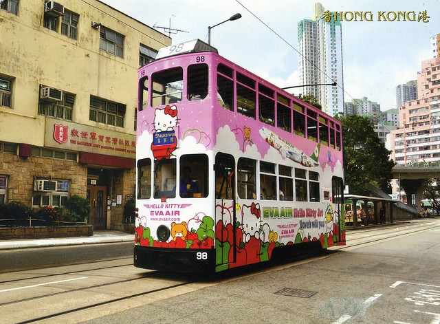
Shau Kei Wan Road, Shau Kei Wan, Hong Kong

Just a very small update for today... starting with this lovely card from Hong Kong that I received earlier this year.


A Hello Kitty tram! :D Apparently they are not very common, or at least that's what Vince who sent me this card told me.

 Shau Kei Wan is a town in The Eastern District, located in the north east of Hong Kong Island. Literally, Shau Kei means a pail, and Wan implies that the town is developed along the coast. Nowadays it is a relatively densely populated town compared with some developing areas.