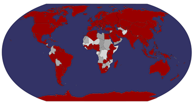
I thought I'd finish today with something a little different...
The headquarters of the United Nations is a distinctive complex in New York City, United States, that has served as the official headquarters of the United Nations since its completion in 1952. It is located in the Turtle Bay neighborhood of Manhattan, on spacious grounds overlooking the East River.
The United Nations has three additional, subsidiary, regional headquarters or headquarter districts. These are located in Geneva (Switzerland), Vienna (Austria), and Nairobi (Kenya). These adjunct offices help represent UN interests, facilitate diplomatic activities, and enjoy certain extraterritorial privileges, but only the main headquarters in New York contains the seats of the principal organs of the UN, including the General Assembly and Security Council. All 15 of the United Nation's specialized agencies are located outside New York at these other headquarters or in other cities.
Though it is in New York City, and part of the United States, the land used by the United Nations Headquarters is considered international territory, while also being subject to most local, state, and federal laws.
...and what makes this postcard so special is the fact that it was mailed directly from the UN Headquarters in New York! The stamp was issued in 2010 to commemorate the 65 years of United Nations. I really like the special cancellation, too.
Saturday, 28 May 2011
Khajuraho Temple, India
I recently received a comment about the lack of Indian postcards in this blog. Well, the main problem here is that I only have a few postcards from India. I keep seeing other people receiving officials from there but I think I've only got three in total.. and there aren't too many members from India on the forum. I do have plans to post about a couple of Indian postcards I DO have so they should appear here eventually. And if anyone would like to contribute to my collection, you're more than welcome to send me a message. ;)
This postcard is from an RR - 'hootnoodle' went on holiday in India and sent me this nice card from there. It shows sculptures in the Hindu temple Khajuraho. It is located in a town in the Indian state of Madhya Pradesh, located in Chhatarpur District, about 620 kilometres (385 mi) southeast of New Delhi, are one of the most popular tourist destinations in India. Khajuraho has the largest group of medieval Hindu and Jain temples, famous for their erotic sculpture. The Khajuraho group of monuments has been listed as a UNESCO World Heritage Site, and is considered to be one of the "seven wonders" of India.
The stamps are from a set of 3 definitives issued in 2008, this one showing Indira Gandhi.
Chania, Crete, Greece
I received this beautiful card via the official postcrossing site earlier this year. It's always nice to receive officials from Greece, and this one is no exception. I didn't actually realise it's a lighthouse on the card when I first looked at it, I just thought it was some kind of tower.. ooops. But it's definitely a lighthouse :)
GR-17202
Chania is the second largest city of Crete and the capital of the Chania peripheral unit. It lies along the north coast of the island, about 70 km west of Rethymno and 145 km west of Heraklion. The official population of the municipal unit (the former municipality) is 55,838 but the greater urban area is 81,985. The urban area consists of the city of Chania along with 7 towns and villages.
The city of Chania can be divided in two parts: the old town and the modern city which is the larger one. The old town is situated next to the old harbour and is the matrix around which the whole urban area was developed. It used to be surrounded by the old Venetian fortifications that started to be built in 1538; of them the eastern and western parts have survived. From the south, the old town is continuous with the new, and from the north the physical border is the sea. The centre of the modern city is the area extending next to the old town and especially towards the south.
Despite being heavily bombed during World War II, Chania's Old Town is considered the most beautiful urban district on Crete, especially the crumbling Venetian harbour. The borders of the Old Town are the mostly destroyed old Venetian wall (and bulwarks) and this has been the cradle of all the civilizations which were developed in the area. The central part of the old town is named Kasteli and has been inhabited since Neolithic times. It is located on a small hill right next to the seafront and has always been the ideal place for a settlement due to its secure position, its location next to the harbour and its proximity to the fertile valley in the south. Nowadays it is a bit more quiet than the neighbouring areas of the west part of the district. The Splantzia quarter (next to the east part of Kasteli) is also largely untouched and very atmospheric.
A very distinctive area of the Old Town is the harbour itself and generally the seafront ("akti"). Akti Tompazi, Akti Kountouriotou and Akti Enoseos (marina) all feature several historical buildings and a thriving nightlife. The main street that combines the modern town with the old town is Halidon Str. The lighthouse on this postcard is located at the mouth of the Venetian port and it's said to be one of the oldest lighthouses in the Mediterranean.
The stamp on the left is from a set of 5 stamps issued in 2010, with the theme 'New Acropolis Museum'. The stamp on the right is from a set of 5 stamps issued earlier this year, depicting 20th Century Art.
Kunerad, Slovakia
I don't have too many postcards from Slovakia so I was really happy to receive this from Wanda of Poland who went on holiday in Slovakia. Thank you so much!
Kunerad is a village and municipality in Žilina District in the Žilina Region of northern Slovakia. In historical records the village was first mentioned in 1490. The municipality lies at an altitude of 494 metres and covers an area of 22.937km². It has a population of about 931 people.
The stamp on the right is from a set of 11 definitives issued in 2009, while the stamp on the right was issued in 2010 and shows President Gasparovic.
Tomsk, Russia
Another train postcard, this time from Russia. For some reason the picture here reminds me of Savonlinna, a small town in Finland where I used to go to university. I'm so glad I don't have to go there anymore, I really didn't like it there. I'm also wondering whether trains to Savonlinna go to the railway station there anymore. The station was closed when I was still living in the town, but you could still catch a train from there, although the train also stopped by the marketplace. Hhmmm... this isn't really relevant to this postcard so I'll stop rambling. :P
Tomsk is a city and the administrative center of Tomsk Oblast, Russia, located on the Tom River. One of the oldest towns in Siberia, Tomsk celebrated its 400th anniversary in 2004. It has a population of around 522,900 (2010).
In 1804, the government selected Tomsk to become the center for a new governorate which would include the modern cities of Novosibirsk, Kemerovo, Krasnoyarsk and eastern Kazakhstan. The new status brought development and the city grew quickly.
The discovery of gold in 1830 brought further development to Tomsk in the 19th century. However, when the Trans-Siberian Railway bypassed the city in favor of the village of Novonikolayevsk (now Novosibirsk), development began to move south to connect with the railway. In time, Novosibirsk would surpass Tomsk in importance.
In the mid-19th century, one-fifth of the city's residents were exiles. However, within a few years, the city would be reinvented as the educational center of Siberia with the establishment of Tomsk State University and Tomsk Polytechnic University. By World War II, every 12th resident of the city was a student, giving rise to the city's informal name - Siberian Athens.
After the Russian Revolution the city was a notable center of the White movement, led by Anatoly Pepelyayev and Maria Bochkareva, among others. After the capture by the Red Army, Tomsk was incorporated into West Siberian Krai and later into Novosibirsk Oblast.
As in many Siberian cities, Tomsk became the new home for many factories relocated out of the War Zone at the beginning of the Second World War. The resulting growth of the city led the Soviet government to establish a new Oblast centered on Tomsk.
The stamps are from a set of 3 stamps issued earlier this year, depicting Russian Regions. The ones here are the Tambov region (left) and Tjumen region (right).
Helsinki, Finland
I've only just realised that I've already had this blog for over a year! I'm quite impressed as when I started this blog I wasn't sure whether I'd manage to keep up with this or whether this would be interesting enough to keep updating. Turns out it has been well worth it. :)
I'm a little nervous at the moment because of the ash cloud from the Icelandic volcano. I'm supposed to fly to Finland for a week with Matt next Sunday, I really hope the ash cloud will have settled by then. I don't want to miss this opportunity, I'm really looking forward to seeing my family again. Hopefully everything will be fine. *fingers crossed* Anyway, in anticipation of this little trip I thought I'd post a Finnish card here. I received this from one of my favourite postcrossers, Essi, not long ago and *really* like it. I find this to be a very typical image of Helsinki.
Hopefully I'll get to ride these lovely green trams again in Helsinki. :) I much prefer them to buses, they have so much more character and the atmosphere is great. My sister doesn't live right in the centre of Helsinki anymore, but these trams go near to where she lives now so I should get to ride these. Yay! Trams were first introduced in Helsinki in 1891 and were initially horse-drawn.
The awesome mailbox stamp is from a set of 5 stamps issued earlier this year, showing - obviously - mailboxes. The smaller stamp showing a birch leaf is a definitive, also issued earlier this year.
Saturday, 21 May 2011
Aksum, Ethiopia
One more card for today, then I'll be back to making my ninja cookies :D This card is also from a new country: Ethiopia! It was kindly sent to me by Sean who was recently staying in Ethiopia. It sounds like he had a really good time there, too - you can read more about his travels here.
This postcard shows the ruins of the ancient city of Aksum, also a Unesco World Heritage Site, found close to Ethiopia's northern border. They mark the location of the heart of ancient Ethiopia, when the Kingdom of Aksum was the most powerful state between the Eastern Roman Empire and Persia. The massive ruins, dating from between the 1st and the 13th century A.D., include monolithic obelisks, giant stelae, royal tombs and the ruins of ancient castles. Long after its political decline in the 10th century, Ethiopian emperors continued to be crowned in Aksum. [source]
The stamp on the right is from a set of 23 definitives issued in 2000, representing animals. I'm not sure of the other stamps as it says it was issued in 2002 but I'm guessing it's a definitive as well.
Malcolm Island, British Columbia, Canada
I've received so many lovely officials this year and this one from Canada is no exception. I just love this view, and the whales at the front make it even more impressive!
CA-161658
Malcolm Island is an island in the Canadian province of British Columbia, located north of Haddington Island in the Queen Charlotte Strait near Vancouver Island. It has ferry access from the Vancouver Island community of Port McNeill. The island is located within the Mount Waddington Regional District.
The main community on Malcolm Island is Sointula, an isolated village with a population of roughly 800 (as of 2008). There's an interesting connection to Finland here - the name "Sointula" (literally the place of chord) means "Place of Harmony" in the Finnish language. It was founded by a group of Finnish settlers, who rowed north from Nanaimo in 1901. They planned on setting up a utopian socialist society known as the "Kalevan Kansa",and wrote to visionary Matti Kurikka in Finland to lead the new community. They were looking for a way out of Dunsmuir's mines in Nanaimo. It was a physically hard life and a devastating fire almost brought the fledgling community to its knees. Financial difficulties continued to plague the group and after working for free for two years on the Capilano Bridge project, the Kalevan Kansa was disbanded. Many of the community members remained on the island and their descendants are still here in 2008.
The town remained and prospered well into the 1970s as an unusually vibrant resource-based settlement. Fishing and logging activities have been the mainstay for the community. The early cooperative ventures planted seeds that are also alive today. The Sointula Cooperative Store, the oldest co-op shop in the province, still handles drygoods, groceries and fuel for the islanders. In addition there is a cooperative bakery, Wild Island Foods, which served Finnish bread (pulla) and home-cooked meals until the summer of 2008. The shellfish cooperative, Malcolm Island Shellfish Coop (MISC), was involved in research on the feasibility of raising and selling abalone, but closed for financial reasons in 2006, relocating the abalone to an area near Port McNeill donated by Orca Sand and Gravel.
In recent decades, declining forestry and fishing industries have hit Sointula hard. Its school-age population has shrunk, although housing prices have risen as owners from as far as California have bought homes as summer retreats. Sointula is home to a museum, and is easy to reach by government car ferry from Port McNeill or Alert Bay.
Sointula is also the name of an area in Valkeakoski, a town in Finland where my mum's mother (and brother and his family) live! I also used to have a relative who lived in Sointula, and I used to have a cleaning job in the area years ago. It's such a small world!
Malcolm Island was named for Admiral Sir Pulteney Malcolm, and the lighthouse on this postcard is called Pulteney Point Lighthouse.
The big stamp is from a set of two stamps issued in 2010, depicting Marine Life, and it's also a joint issue with Sweden. The small stamps, unless I'm very much mistaken, are from a set of 5 stamps, also issued in 2010, to commemorate the Vancouver Winter Olympics.
Labels:
2011,
british columbia,
canada,
finland,
lighthouses,
officials,
sointula
Cameron Highlands, Malaysia
A lovely, lovely card I received from Chris in Malaysia earlier this year. Just look at it, isn't it gorgeous?!
I've already written about Cameron Highlands here so I won't repeat myself here, I'll just note what Christ told me of the area: it's much cooler than the rest of Malaysia and tea, vegetables, flowers and even strawberries are grown there. It's a popular tourist destination and about 4 hours drive from the capital, Kuala Lumpur. Incidentally, this is also Chris's favourite Malaysian postcard and it's not difficult to see why. It's such a tranquil, dream-like view, absolutely amazing!
The stamp is from a set of 4 flower stamps issued in 2008.
Romania
Moving on to more rural settings... This card came from a swap with Oana in Romania. I don't have too many postcards from Romania so it's always nice to see new views from there. :)
The bottom picture shows a village near to Cluj in nortwestern Romania, while the top right picture shows Valea Stanciului, a small commune in southern Romania. There's a bit more to say about the top left picture - it shows Danube Delta, which is also a Unesco World Heritage Site.
Danube Delta is the second largest river delta in Europe, after the Volga Delta, and is the best preserved on the continent. The greater part of the Danube Delta lies in Romania (Tulcea county), while its northern part, on the left bank of the Chilia arm, is situated in Ukraine (Odessa Oblast). The approximate surface is 4152 km², of which 3446 km² are in Romania. If the lagoons of Razim-Sinoe (1015 km² of which 865 km² water surface; situated in the south, but attached to the Danube Delta from geological and ecological perspectives, as well as being the combined territory of the World Heritage Site) are to be added, the considered area of the Danube Delta grows to 5165 km².
The modern Danube Delta began forming after 4,000 B.C. in a gulf of the Black Sea, when the sea rose to its present level. A sandy barrier blocked the Danube gulf where the river initially built its delta. Upon filling the gulf with sediments, the delta advanced outside the barrier-blocked estuary after 3,500 B.C. building several successive lobes: the St. George I (3,500-1,600 B.C.), the Sulina (1,600-0 B.C.), the St. George II (0 B.C.-Present) and the Chilia or Kilia (1600 A.D.-Present).
The Danube Delta is a low alluvial plain, mostly covered by wetlands and water. It consists of an intricate pattern of marshes, channels, streamlets and lakes. The average altitude is 0.52 m, with 20% of the territory below sea level, and more than half not exceeding one meter in altitude. Dunes on the most extensive strandplains of the delta (Letea and Caraorman strandplains) stand higher (12.4 m and 7 m respectively). The largest lakes are Dranov (21.7 km²), Roşu (14.5 km²), Gorgova (13.8 km²).
The stamp is from a set of 2 issued in 2010, with the theme 'Carpates'.
Brussels, Belgium
A very nice official I received earlier this year, showing Brussels from a slightly different angle.
BE-92626
Brussels is the de facto capital of Belgium and of the European Union. It is also the largest urban area in Belgium, comprising 19 municipalities.
Brussels has grown from a 10th-century fortress town founded by a descendant of Charlemagne into a metropolis of more than one million inhabitants. The metropolitan area has a population of over 1.8 million, making it the largest in Belgium.
Since the end of the Second World War, Brussels has been a main center for international politics. Hosting principal EU institutions as well as the headquarters of the North Atlantic Treaty Organization (NATO), the city has become the polyglot home of numerous international organisations, politicians, diplomats and civil servants.
Although historically Dutch-speaking, Brussels became increasingly French-speaking over the 19th and 20th centuries. Today a majority of inhabitants are native French-speakers, and both languages have official status. Linguistic tensions remain, and the language laws of the municipalities surrounding Brussels are an issue of considerable controversy in Belgium. ...this reminds me, my sister visited Brussels some years ago but had to leave pretty soon because most people only spoke French and she doesn't speak/understand it, and she preferred Amsterdam anyway :p On the other hand, I used to have a penpal who lived in Brussels, and the image she gave me of the city was completely different. I guess it depends on who you are and where you go...
The stamp is the very common flower definitive issued in 2009.
Brussels is the de facto capital of Belgium and of the European Union. It is also the largest urban area in Belgium, comprising 19 municipalities.
Brussels has grown from a 10th-century fortress town founded by a descendant of Charlemagne into a metropolis of more than one million inhabitants. The metropolitan area has a population of over 1.8 million, making it the largest in Belgium.
Since the end of the Second World War, Brussels has been a main center for international politics. Hosting principal EU institutions as well as the headquarters of the North Atlantic Treaty Organization (NATO), the city has become the polyglot home of numerous international organisations, politicians, diplomats and civil servants.
Although historically Dutch-speaking, Brussels became increasingly French-speaking over the 19th and 20th centuries. Today a majority of inhabitants are native French-speakers, and both languages have official status. Linguistic tensions remain, and the language laws of the municipalities surrounding Brussels are an issue of considerable controversy in Belgium. ...this reminds me, my sister visited Brussels some years ago but had to leave pretty soon because most people only spoke French and she doesn't speak/understand it, and she preferred Amsterdam anyway :p On the other hand, I used to have a penpal who lived in Brussels, and the image she gave me of the city was completely different. I guess it depends on who you are and where you go...
The stamp is the very common flower definitive issued in 2009.
Giant Buddha, Hong Kong
Trying to catch up with this blog so I'm updating again. :D Well, I do have quite a lot of free time at the moment. I haven't had any translation assignments for a while and I have a feeling I might not receive too many in the future, either.. :/ At least then I won't have to stress about them, but I'd still prefer getting some occasional assignments as money is always welcome and I never have enough. Mmmmm... anyway. I'm supposed to go for a picnic tomorrow with friends from aikido, only I'm a little worried as according to weather reports, it's likely to rain tomorrow and you can't really have a nice picnic in a park if it's raining. :( I'm trying to be positive though and am making some ninja cookies for tomorrow (I got an awesome "ninjabread men" cookie cutter set from Matt's older sister Rachel for my birthday :D). The dough needs to chill for several hours in the fridge, though, so I have plenty of time to do other things.
One of my friends in our aikido group, Miranda, is originally from Hong Kong and she's only just come back from a visit back home. She didn't bring me any postcards this time but then again, I already have plenty. ...and I got this nice card from the 'Choose a country' RR on the postcrossing forum a while ago. :)
Giant Buddha is a large bronze statue of a Buddha, completed in 1993, and located at Ngong Ping, Lantau Island, in Hong Kong. The statue is located near Po Lin Monastery and symbolises the harmonious relationship between man and nature, people and religion. It is a major centre of Buddhism in Hong Kong, and is also a popular tourist attraction. It is 26.4 metres high and weighs 202 tonnes. It's the world's largest seated outdoor bronze Buddha.
The bird stamps come from a set of 16 definitives issued in 2006, the ones here showing the Fork-tailed Sunbird and Collared Scops Owl. The stamp on the right is from a set of 4 stamps issued earlier this year, with the theme 'Volunteerism'.
Thursday, 19 May 2011
Prishtina, Kosovo
One more card for today, and this one is quite a treat, too, or at least something I never thought I'd ever get. I mean Kosovo isn't exactly a hugely popular tourist destination... I can't help feeling a little sad looking at this postcard. It's what the sender, "pierresurleciel" wrote, it's so sad to see how two nations live side by side but not together, and not even understanding the other side's language. Here's hoping the situation over there will get better one day.
Prishtina is the capital and largest city of Kosovo. It is the administrative centre of the homonymous municipality and district.
It is estimated that the current population of the city stands between 500,000 and 600,000. Preliminary results of 2011 census puts population of Pristina at 200.000. The city has a majority Albanian population, alongside other smaller communities including Bosniaks, Roma and others. It is the administrative, educational, and cultural centre of Kosovo. The city is home to the University of Pristina and is served by the Pristina International Airport.
Prishtina lies in the north-eastern part of Kosovo close to the Goljak mountains. From Pristina there is a good view of the Šar Mountains which lie several kilometres away in the south of Kosovo. Pristina is located beside two large towns, Obilić and Kosovo Polje. In fact Pristina has grown so much these past years that it has connected with Kosovo Polje. Lake Badovac is just a few kilometres to the south of the city.
The stamp is from a set of 5 stamps depicting local costumes, issued in 2007 by the United Nations Adminstration Kosovo.
Rachaya al Foukhar, Lebanon
This beautiful card is from a swap with Abed in Lebanon. Isn't it a lovely view?! Abed tells me that this village seems like the last untouched area of Lebanon which hasn't yet been disfigured by Western architecture.
Located 150km south-east of Lebanon on Mount Hermon slopes, Rachaya al Foukhar is located in Lebanon’s Eastern chain of mountains. It has 750m of altitude, its highest summit being at 1250m at the Qabr Uthman site, considered to be one of the strategic points in Wadi al Taym.
There is no precise date about the first human settlement in Rachaya al Foukhar. It is though confirmed that the area was long inhabited due to the Aramaic origin of its name. It also has several Roman ruins, ancient jars, as well as very old olive trees. The big olive tree field west of Rachaya al Foukhar is said to contain trees dating back to the Roman Empire.
According to the famous author Anis Freiha, Rachaya al Foukhar is composed of two different origins: the first, Rachaya or rather Rashana, stems from the Aramaic or Syrian (Suryaniyyah) language. It means the masters or lords who inhabited those hills.
With time, the Arabs started using the word Rachaya for it was easier to pronounce. As for the second word, al Foukhar, it stems from the Arabic and means pottery, a traditional handicraft in the village. However, due to war and economic difficulties, the production decreased and nowadays, only 3 to 4 craftsmen still do pottery. It is no secret that they lack funding and support to bring back this industry to its previous prosperity. [source]
The stamp is from a set of 10 definitives issued in 2010.
Lake Ladoga, Karelia
I have a soft spot for postcards of the Russian Karelia, maybe because it looks so much like the Finnish Karelia (well, parts of the Russian Karelia used to belong to Finland) so it reminds me a lot of home. The view on this postcard, for instance, could easily be from around where I'm from, they have very similar views there too. This card reminds me of childhood holidays and more recently journeys to and from the town where I used to study at university.
Lake Ladoga ('Laatokka' in Finnish) is a freshwater lake located in the Republic of Karelia and Leningrad Oblast in northwestern Russia, not far from Saint Petersburg. It is the largest lake in Europe, and the 14th largest lake by area in the world.
The Ladoga is rich with fish. 48 forms (species and infraspecific taxa) of fish have been encountered in the lake, including roach, carp bream, zander, European perch, ruffe, endemic variety of smelt, two varieties of Coregonus albula (vendace), eight varieties of Coregonus lavaretus, a number of other Salmonidae as well as, albeit rarely, endangered European sea sturgeon. Commercial fishing was once a major industry but has been hurt by overfishing. After the war, between 1945–1954, the total annual catch increased and reached a maximum of 4,900 tonnes. However, unbalanced fishery led to the drastic decrease of catch in 1955–1963, sometimes to 1,600 tonnes per year. Trawling has been forbidden in Lake Ladoga since 1956 and some other restrictions were imposed. The situation gradually recovered, and in 1971-1990 the catch ranged between 4,900 and 6,900 tonnes per year, about the same level as the total catch in 1938. Fish farms and recreational fishing are developing.
Lake Ladoga has its own endemic Ringed Seal subspecies known as the Ladoga Seal.
Nizhnesvirsky Natural Reserve is situated along the shore of Lake Ladoga immediately to the north of the mouth of the River Svir.
The stamps on the right and middle are from a set of 4 stamps issued in 2009, depicting Russian National Head dresses in Middle of XIX Century. The one on the right shows a head dress from Yaroslavl Province, while the one in the middle is from Nizhniy Novgorod Province. The stamp on the left was issued in 1999 in a set of 3 stamps showing Brullow paintings.
Puerto Rico
I don't have too many postcards from Puerto Rico so I'm always up for swaps with people from there and couldn't possibly say 'no' to Eduardo who asked me earlier this year if I'd like to swap with him.
This is a view of Fort San Felipe del Morro from Isla de Cabras, an islet located at the entrance of the San Juan bay in Puerto Rico. Fort San Felipe del Morro, or Morro Castle (Spanish: Castillo San Felipe del Morro) is a 16th-century citadel located on the northwestern-most point of the islet of San Juan, Puerto Rico. Named in honor of King Philip II of Spain, the fort, also referred to as 'el Morro' or promontory, was designed to guard the entrance to the San Juan Bay, and defend the city of Old San Juan from seaborne enemies. In 1983, during the Reagan Administration, the fort was declared a World Heritage Site by the United Nations in conjunction with the San Juan National Historic Site. Over two million visitors a year explore the windswept ramparts and passageways making the fort one of Puerto Rico's main visitor attractions. Facing the structure, on the opposite side of the bay, a smaller fort known as El Cañuelo complemented the fort's defense of the entrance to the bay.
US stamps are used in Puerto Rico. This one is a rather familiar one...
Vietnamese girl
Today's cards are a bit of a mixed batch again. I could probably figure out a theme for my posts by now as I have so many waiting to be blogged about, but I prefer it this way for now. The last week has been pretty hectic, what with a birthday party (I turned 29 a week ago), aikido, volunteering.. and yesterday I went to Birmingham for some wedding-related stuff, although I did pick up a few postcards as well. ;)
Anyway. My first postcard for today comes from dear Jo in Vietnam. Earlier this year she offered her most favourites postcard for swap and of course I had to ask for one. It's SUCH a pretty card, no wonder it's so popular (although to be honest, I think most of Jo's cards are really beautiful, I don't think I could ever pick my favourite amongst them!).
This little girl is from Sapa in northern Vietnam where many of Vietnam's ethnic minority groups live. Jo tells me that Sapa is the only place in Vietnam where it ever snows, and earlier this year it snowed there for the first time in 8 years.
As of 2003, Sapa had a population of 42,095. The district covers an area of 677 km² and its capital lies at Sa Pa.
The stamps are from a set of 2 flower stamps issued in 2010.
Wednesday, 11 May 2011
Tristan da Cunha
One more card for today.. and from a very special place: Tristan da Cunha!! It took some organising, but the staff at the Post Office at Tristan were super helpful and nice, and in the end they sent me SEVEN written and stamped postcards! Wow! They all arrived yesterday and I was SO excited, they are definitely some of the coolest cards I've ever received. It was like an early birthday present (my birthday is tomorrow)! :) I'm probably going to post some more here later, but here's the first one, of 'Edinburgh of the Seven Seas'.
Tristan da Cunha is a remote volcanic group of islands in the south Atlantic Ocean and the main island of that group. It is the most remote inhabited archipelago in the world, lying 2,816 kilometres from the nearest land, South Africa, and 3,360 kilometres from South America. Tristan da Cunha is said to be the "most remote inhabited location on Earth." The territory consists of the main island of Tristan da Cunha itself, which measures about 11.27 kilometres across and has an area of 98 square kilometres, along with the uninhabited Nightingale Islands and the wildlife reserves of Inaccessible Island and Gough Island. It has a permanent population of 275 (2009 figures).
Tristan da Cunha is part of the British overseas territory of Saint Helena, Ascension and Tristan da Cunha which also includes Saint Helena 2,430 kilometres to its north, and equatorial Ascension Island even farther removed, grouping the British South Atlantic islands into one far-flung centrally administered aggregate.
The stamp is from a set of 6 stamps issued in 2009, depicting Potato Production. I was really surprised the cards arrived so soon, I mean they travelled for less than a month! That's pretty impressive considering there's no airport on the island so they have to use ships for everything.
Borgund Stave Church, Norway
Another official, but this one is much older, back from 2008. It's from Joey who used to be the most active postcrosser in Norway, but he's since left Postcrossing, which is a shame as he was such a nice guy. I've received a few cards from him and they are all great.
NO-17520
Borgund Stave Church is a stave church located in Borgund, Lærdal, Norway. It is classified as a triple nave stave church of the so-called Sogn-type. This is also the best preserved of Norway's 28 extant stave churches.
Borgund was built sometime between AD 1180 and 1250 with later additions and restorations. Its walls are formed by vertical wooden boards, or staves, hence the name stave church. The 4 corner posts were connected to one another by ground sills, resting atop a stone foundation. The rest of the staves then rise from the ground sills, each stave notched and grooved along the sides so that they lock into one another, forming a sturdy wall.
Borgund has tiered, overhanging roofs, topped with a tower. On the gables of the roof, there are four carved dragon heads, swooping from the carved roof ridge crests, recalling the carved dragon heads found on the prows of Norse ships. Similar gable heads also appear on small bronze house shaped reliquaries common in Norway in this period. Borgund’s current dragon heads possibly date from the 18th century, however original dragon heads remaining on earlier structures, such as the stave church at Lom stave church and nearby Urnes stave church, the oldest still extant stave church, also in the Sogn district, suggest that there probably would have been similar dragon heads there at one time. Borgund is one of the only churches to still have preserved its ridge crests, carved with openwork vine and vegetal repeating designs.
The stamp on the right is from a set of 4 stamps issued in 2008, with the theme 'Transport'. The other one I couldn't find any info of.
Shymkent, Kazakhstan
I very rarely get "new" countries on the official postcrossing site these days. I don't mind receiving cards from the same countries but I can't deny it's nice to get the occasional new country, it's always a nice surprise finding something a little different in my mailbox. This is one such card. I have a few postcards from Kazakhstan through swaps and such, but this is my first official from there.
KZ-1749
The picture is from Shymkent, and the people here are wearing traditional clothes from the area. Shymkent is the capital city of South Kazakhstan Province, the most populated region in Kazakhstan. It is the third most populous city in Kazakhstan behind Almaty and Astana with a population of 629,600 (2011). A major railroad junction on the Turkestan-Siberia Railway, the city is also a notable cultural centre, with an international airport. It is situated 690 km west of Almaty and 120 km to the north of Tashkent, Uzbekistan.
The "stamp" on the right is printed directly on the envelope the card arrived in. The other two were issued in 2010, to commemorate the 125th Birth Anniversary of Mirzhakyp Dulatov.
Novosibirsk, Russia
I'd been wanting this card for quite a while, I'm so happy to finally have it!
The card shows the Novosibirsk Puppet Theatre, where you will be able to view many beautiful handmade puppets and marionettes from the past. Housed in an especially attraction historical building, the theatre dates back to the late 1930s and features regular performances for all ages.
Novosibirsk, then, Russia's third-largest city, after Moscow and Saint Petersburg, and the largest city of Siberia, with a population of 1,473,700 (2010). It is the administrative center of Novosibirsk Oblast as well as of the Siberian Federal District. The city is located in the southwestern portion of the federal district and occupies an area of 477.2 square kilometres.
The city was founded in 1893 at the future site of a Trans-Siberian Railway bridge crossing the great Siberian river of Ob. It was named Novonikolayevsk (Новониколаевск), in honor of both Saint Nicholas and the reigning tsar, Nicholas II. The bridge was completed in the spring of 1897, making the new settlement the regional transport hub. The importance of the city further increased with the completion of the Turkestan-Siberia Railway in the early 20th century.
Novosibirsk is a large industrial center. The industrial complex consists of 214 large and average industrial enterprises. These produce more than two thirds of all industrial output of the Novosibirsk region. Leading industries are the electric power industry, gas supply, water supply, metallurgy, metal working, and mechanical engineering.
Theh stamp on the top right is a Europa stamp from 2004, that year's topic being Tourism (?!). The smaller stamps are definitives from 2008 in a set of 15 stamps, the ones here representing representing a Brown Bear, Fox and Hare. The stamp at the bottom is from 2001 and is Russia's contribution to that year's Europa stamps series, that year's theme being 'water'.
Postcrossing International meet-up, London, 7 May 2011
So I went to London on Saturday last week, to attend an International Postcrossing meet-up. I had a great time - good company, the weather was nice, there were lots of postcards.. what more can you ask? :P
The meet-up was originally going to take place a week earlier but had to be postponed because of the Royal Wedding. I don't mind, we got better weather now at least. :) It was really warm and sunny, so un-British, lol! There were people from the UK, Ireland, the Netherlands, Belgium, Germany, Switzerland and Romania there. It was good to meet old friends, and some new faces as well. Everyone was really nice and friendly, and Steve particularly was super helpful, so special thanks to him! I wish I could've stayed longer but I had to leave early in order to catch my coach. Grrrr... My photos from the meet-up are here.
I sent a bunch of cards to friends, some of them have already arrived and hopefully the rest of them will arrive soon, too. Last year I really wished I would've sent a card for myself as well, so this year I made sure I had one for myself. I didn't want a cliched London postcard so I chose this one from The Caravan Gallery. Their postcards are hilarious, and pretty accurate as well. :D
A couple of people had to leave early but here are the signatures of most of the people who were there. I used an older stamp to mail this card. It's from a set of 10 black & white stamps issued in 2001, depicting cats and dogs.
Thursday, 5 May 2011
Map of Israel
One more card for today. I did want to do a bigger update but I'm too busy, too many things to do and I'm also trying to get everything sorted and ready for the Postcrossing meet-up in London this Saturday.
This card is from the lovely Debora in Israel. I've received a few postcards from her and it's always a joy to get mail from her. This card is from a tag, isn't it adorable! I love mapcards and it's nice to see some rather different ones such as this one occasionally. The illustrations here remind me of some 80's children's books, the style is pretty similar to some I vaguely remember reading/looking at as a child.
Israeli stamps are so pretty! The one on the left is from a set of 5 stamps issued in 2009, depicting Fruits. This one here is Orange. The other stamp is from a set of 2 stamps issued in 2010, with the theme 'Cinemas in Israel'. The one here shows the Zion Cinema in Jerusalem.
Colmar, France
Another official... This one is quite possibly one of my favourite official postcrossing cards I've received so far this year. The houses look so pretty and colourful, and the card has a matching stamp!
FR-139301
Colmar is a commune in the Haut-Rhin department in north-eastern France. It is situated along the Alsatian Wine Route and considers itself to be the "Capital of Alsatian Wine" (capitale des vins d'Alsace). In 2006, the city of Colmar had a population of 65,713 and the metropolitan area of Colmar had a population of 120,367. Colmar is the center of the arrondissement of Colmar, which has 144,700 inhabitants in 2006.
Colmar is the home town of the painter and engraver Martin Schongauer and the sculptor Frédéric Bartholdi, who designed the Statue of Liberty. The city is renowned for its well preserved old town, its numerous architectural landmarks and its museums, among which the Unterlinden Museum.
Like I said, this card came with a matching stamp, issued in 2010. The other two stamps are from a set of 14 definitives issued in 2008, with the theme 'Marianne and Europe'.
Bernina Express, Switzerland
This very nice card arrived as an official earlier this year. The sender lives in Germany but she was on holiday in Switzerland and picked up this card from there. I'm not complaining, it's very pretty and for once I don't really mind it being a multiview.
DE-846421
The Bernina Express is an express train connecting Chur (or Davos) in Switzerland with Poschiavo and Tirano in Italy, by crossing the Swiss Alps from north to south. For most of its journey, the train also passes along and through the World Heritage Site known as the Rhaetian Railway in the Albula / Bernina Landscapes.
The train is operated by the Rhaetian Railway company. It is not an "express" in the sense of being a high-speed train, but, rather, in the sense that it provides a one-seat ride for a long duration trip. The Bernina Express itself is composed of panoramic coaches with a piped multi-lingual commentary, and a small supplement and seat reservation are both obligatory. The train is popular with tourists, and connects in Tirano with the Post Bus service via Lake Como in Italy to Lugano in Switzerland.
The Albula line and the Bernina line on the Bernina Express route were jointly declared a World Heritage Site in 2008. The trip on the Bernina Express through this World Heritage Site is a 4 hour railway journey across 196 bridges, through 55 tunnels and across the Bernina Pass on the highest point at 2,253 metres in altitude. The entire line is 1,000 mm (3 ft 3 3⁄8 in) (metre gauge).
This card was mailed from Germany. The stamp on the right was issued in 2006 and represents 'spring'. Unless I'm very much mistaken, it's from a set of 4 stamps depicting the four seasons. The other one is one of those automated labels, this one showing Brandenburg Gate in Berlin.
Subscribe to:
Posts (Atom)