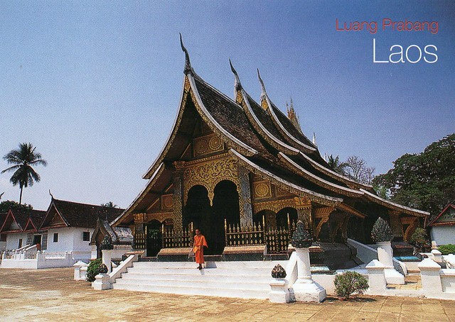
Today's last card is another surprise from Jobbo. Thank you a million, I *really* like this card, and it's my first written & stamped postcard from Laos, too! I've received a postcard of Luang Prabang before, but that one was mailed from Thailand for some reason.
According to Unesco, Luang Prabang is an outstanding example of the fusion of traditional architecture and Lao urban structures with those built by the European colonial authorities in the 19th and 20th centuries. Its unique, remarkably well-preserved townscape illustrates a key stage in the blending of these two distinct cultural traditions.
The richness of Luang Prabang architecture reflects the mix of styles and materials. The majority of the buildings are, following tradition, wooden structures. Only the temples are in stone, whereas one- or two-storey brick houses characterize the colonial element of the town. The many pagodas or "Vat" in Luang Prabang, which are among the most sophisticated Buddhist temples in Southeast Asia, are richly decorated (sculptures, engravings, paintings, gilding and furniture pieces). Wat Xieng Thong, which dates from the 16th century, comprises an ensemble of the most complex structures of all the pagodas of the town. It is remarkable both from the archaeological point of view, and from the Lao iconographic and aesthetic viewpoint.
Many traditional Lao houses remain; they are built of wood using traditional techniques and materials introduced in the colonial period, such as plaited bamboo panels coated with wattle and daub. Brick colonial buildings, often with balconies and other decorative features in wood, line the main street and the Mekong.
The built heritage of Luang Prabang is in perfect harmony in the natural environment. The sacred Mount Phousi stands at the heart of the historic town built on a peninsula delimited by the Mekong and the Nam Khan, domain of the mythical naga. Ceremonies to appease the nagas and other evil spirits, and Buddhist religious practices (Prabang procession, the monks’ morning quest) perpetuate the sanctity of the place. Natural spaces located in the heart of the city and along the riverbanks, and wetlands (a complex network of ponds used for fish farming and vegetable growing) complement this preserved natural environment.
Friday, 19 February 2016
Historic Mosque City of Bagerhat, Bangladesh
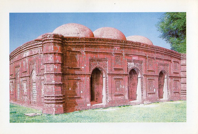
This is of the cards I received from Md. Imran in Bangladesh last year. ...and this one shows a Unesco site, too! :) This card shows the Historic Shat Gambuj Mosque in Bagerhat.
The Historic Mosque City of Bagerhat is an important evidence of medieval city in the south-west part of present Bagerhat district which is located in the south-west part of Bangladesh, at the meeting-point of the Ganges and Brahmaputra rivers. The ancient city, formerly known as Khalifatabad, sprawls over on the southern bank of the old river Bhairab and flourished in the 15th century BC.
The magnificent city, which extended for 50 km2, contains some of the most significant buildings of the initial period of the development of Muslim architecture of Bengal. They include 360 mosques, public buildings, mausoleums, bridges, roads, water tanks and other public buildings constructed from baked brick.
This old city, created within a few years and covered up by the jungle after the death of its founder in 1459, is striking because of certain uncommon features. The density of Islamic religious monuments is explained by the piety of Khan Jahan, which is evidenced by the engraved inscription on his tomb. The lack of fortifications is attributable to the possibilities of retreat into the impenetrable mangrove swamps of the Sunderbans. The quality of the infrastructures - the supply and evacuation of water, the cisterns and reservoirs, the roads and bridges - all reveal a perfect mastery of the techniques of planning and a will towards spatial organization.
The monuments, which have been partially disengaged from the vegetation, may be divided into two principal zones 6.5 km apart: to the West, around the mosque of Shait-Gumbad and to the East, around the mausoleum of Khan Jahan. More than 50 monuments have been catalogued: in the first group, the mosques of Singar, Bibi Begni and Clumakkola; and in the second, the mosques of Reza Khoda, Zindavir and Ranvijoypur.
Greetings from Pakistan
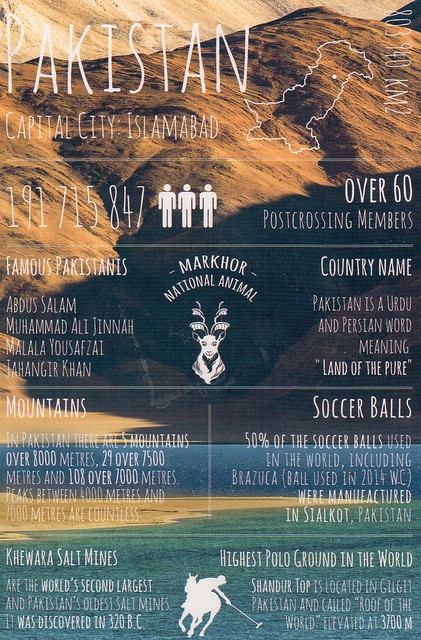
I somehow ended up with two of these... ooops. Oh, and if the post I saw on Instagram this morning is true, I'm finally having to give up collecting this series. Well, I'll try to get them if I can but I won't be able to be too desperate anymore - apparently the next batch will include Albania, Ghana, North Korea and Oman! What the....?! I wonder if the designer has finally realised how ridiculous this has become? :P There aren't even any Postcrossers in North Korea (well, according to the stats there is one who last logged in over 5 years ago and has sent a grand total of 1 postcard, possibly from South Korea) and the only people who have been sending anything out from there have been foreigners. Maybe the batch after that one will include Antarctica, South Sudan and Somalia?? :P
Pakistan, officially the Islamic Republic of Pakistan, is a country in South Asia. It is the sixth-most populous country with a population exceeding 199 million people. It is the 36th largest country in the world in terms of area with an area covering 881,913 km2. Pakistan has a 1,046-kilometre coastline along the Arabian Sea and the Gulf of Oman in the south and is bordered by India to the east, Afghanistan to the west, Iran to the southwest and China in the far northeast respectively. It is separated from Tajikistan by Afghanistan's narrow Wakhan Corridor in the north, and also shares a maritime border with Oman.
The territory that now constitutes Pakistan was previously home to several ancient cultures, including the Mehrgarh of the Neolithic and the Bronze Age Indus Valley Civilisation, and was later home to kingdoms ruled by people of different faiths and cultures, including Hindus, Indo-Greeks, Muslims, Turco-Mongols, Afghans and Sikhs. The area has been ruled by numerous empires and dynasties, including the Indian Mauryan Empire, the Persian Achaemenid Empire, Alexander of Macedonia, the Arab Umayyad Caliphate, the Mongol Empire, the Mughal Empire, the Durrani Empire, the Sikh Empire and the British Empire. As a result of the Pakistan Movement led by Muhammad Ali Jinnah and the subcontinent's struggle for independence, Pakistan was created in 1947 as an independent nation for Muslims from the regions in the east and west of the Subcontinent where there was a Muslim majority. Initially a dominion, Pakistan adopted a new constitution in 1956, becoming an Islamic republic. A civil war in 1971 resulted in the secession of East Pakistan as the new country of Bangladesh.
Pakistan is a federal parliamentary republic consisting of four provinces and four federal territories. It is an ethnically and linguistically diverse country, with a similar variation in its geography and wildlife. A regional and middle power, Pakistan has the seventh largest standing armed forces in the world and is also a nuclear power as well as a declared nuclear-weapons state, being the only nation in the Muslim world, and the second in South Asia, to have that status. It has a semi-industrialised economy with a well-integrated agriculture sector, its economy is the 26th largest in the world in terms of purchasing power and 45th largest in terms of nominal GDP and is also characterized among the emerging and growth-leading economies of the world.
The post-independence history of Pakistan has been characterised by periods of military rule, political instability and conflicts with neighbouring India. The country continues to face challenging problems, including overpopulation, terrorism, poverty, illiteracy, and corruption. Despite these factors it maintains strategic endowments and development potential while it has made substantial progress in reducing poverty giving it the second lowest headcount poverty rate in South Asia. It is ranked 16th on the 2012 Happy Planet Index, while its stock exchange has been among the highest performing in Asia.
The stamps on the first card...
....and the second.
Stewart Island, New Zealand
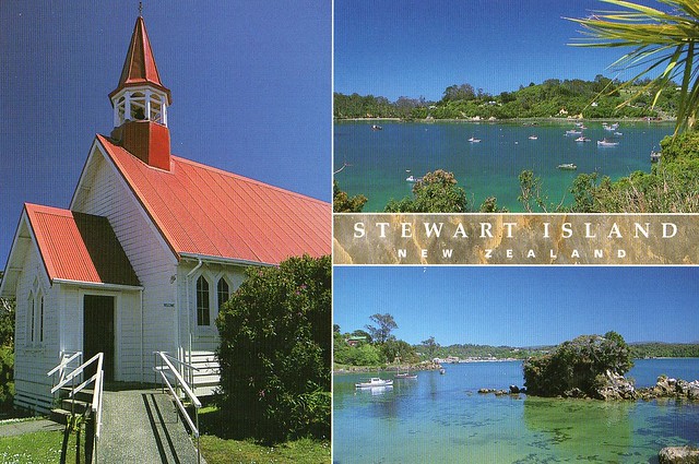
A wonderful card from a swap last year. I'm a little embarrassed to confess I didn't really know anything about Stewart Island in New Zealand until I read about it in the Postcrossing blog.
Stewart Island (officially named Stewart Island/Rakiura) is the third-largest island of New Zealand. It lies 30 kilometres south of the South Island, across the Foveaux Strait. Its permanent population is 381 people as of the 2013 census, most of whom live in the settlement of Oban on the eastern side of the island.
Stewart Island has an area of 1,680 square kilometres. It is hilly and has a wet climate. The north is dominated by the swampy valley of the Freshwater River. The river rises close to the northwestern coast and flows southeastwards into the large indentation of Paterson Inlet. The highest peak is Mount Anglem (979 metres), close to the northern coast. It is one of a rim of ridges that surround Freshwater Valley. The southern half is more uniformly undulating, rising to a ridge that runs south from the valley of the Rakeahua River, which also flows into Paterson Inlet. The southernmost point in this ridge is Mount Allen, at 750 metres. In the southeast the land is somewhat lower, and is drained by the valleys of the Toitoi River, Lords River, and Heron River. South West Cape on this island is the southernmost point of the main islands of New Zealand.
The only town is Oban, on Halfmoon Bay. A previous settlement, Port Pegasus, once boasted several stores and a post office, and was located on the southern coast of the island. It is now uninhabited, and is accessible only by boat or by an arduous hike through the island. Another site of former settlement is at Port William, a four-hour walk around the north coast from Oban, where immigrants from the Shetland Islands settled in the early 1870s. This was unsuccessful, and the settlers left within one to two years, most for sawmilling villages elsewhere on the island.
Fishing has been, historically, the most important element of the economy of Stewart Island/Rakiura, and while it remains important, tourism has become the main source of income for islanders. There has also been some farming and forestry. Oban has mainly sealed main roads, and some gravel roads on the outskirts.
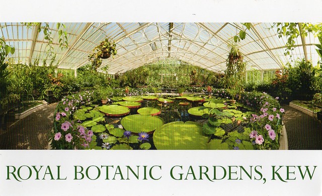
Royal Botanic Gardens, Kew, England
I honestly thought I already had a postcard of Kew Gardens but when I was updating my Unesco postcard list, it wasn't there. I'm missing some other pretty obvious UK sites as well. O_o Well, at least I've got this one now! I've never actually been to Kew Gardens... Last year when my sister came to London and I went to visit her, we did talk about possibly going there, but then just ended up wandering around central London. :p Maybe one day?
Set amongst a series of parks and estates along the River Thames' south-western reaches, this historic landscape garden includes work by internationally renowned landscape architects Bridgeman, Kent, Chambers, Capability Brown and Nesfield illustrating significant periods in garden design from the 18th to the 20th centuries. The gardens house extensive botanic collections (conserved plants, living plants and documents) that have been considerably enriched through the centuries. Since their creation in 1759, the gardens have made a significant and uninterrupted contribution to the study of plant diversity, plant systematics and economic botany.
The landscape design of Kew Botanic Gardens, their buildings and plant collections combine to form a unique testimony to developments in garden art and botanical science that were subsequently diffused around the world. The 18th century English landscape garden concept was adopted in Europe and Kew's influence in horticulture, plant classification and economic botany spread internationally from the time of Joseph Banks' directorship in the 1770s. As the focus of a growing level of botanic activity, the mid 19th century garden, which overlays earlier royal landscape gardens is centred on two large iron framed glasshouses - the Palm House and the Temperate House that became models for conservatories around the world. Elements of the 18th and 19th century layers including the Orangery, Queen Charlotte's Cottage; the folly temples; Rhododendron Dell, boundary ha-ha; garden vistas to William Chambers' pagoda and Syon Park House; iron framed glasshouses; ornamental lakes and ponds; herbarium and plant collections convey the history of the Gardens' development from royal retreat and pleasure garden to national botanical and horticultural garden before becoming a modern institution of conservation ecology in the 20th century.
I wish Royal Mail would cancel stamps on mail... This happens far too often. :(
mailboxes, Germany
Now, this isn't the kind of card I normally post in this blog. ...which I suppose it's a little strange because I really, really like this kind of cards and a lot of my favourite postcards are not view cards. And yet I mainly seem to post view cards here. O_o Anyway, last year I mentioned in a postcard group on Facebook that when I first started Postcrossing, I received a few postcards from Norbert ('Nordbaer') in Germany and really liked them, and that I missed his cards as he's such a wonderful person. Someone relayed my comment to him and I received a postcard from him. :) This is one of the reasons why I love Postcrossing and the postcard community on Facebook. Well, people I "know" anyway. I must confess I'm not too much into the big Postcrossing group on FB. Some people are not very polite there and have strange demands.. ...and the photo proof requests still nark me a little bit, even though I can understand the reasoning behind them. (You never get these requests on the PC forum, though!) I'm actually more drawn towards official Postcrossing again as I've received some really lovely cards recently, and some very nice messages as well. I like the relative spontaneity of it all. I just wish my address didn't keep getting given out too many times. I wonder if that problem is ever going to be fixed as it's been a few years now. It's my main gripe with the official Postcrossing site.
Anyway, mailboxes! These are so bright and lovely, I wonder if they are still in use.. I might have mentioned it before but we don't even have a mailbox, just a slot in the front door.
Anyway, mailboxes! These are so bright and lovely, I wonder if they are still in use.. I might have mentioned it before but we don't even have a mailbox, just a slot in the front door.
Tuesday, 9 February 2016
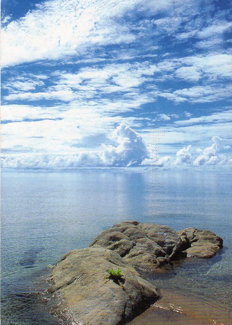
Lake Malawi, Malawi
This is my first written and stamped postcard received from Malawi! It's one of those postcards I never expected to receive. Well, pretty much all African countries are like that to me... :p
Lake Malawi, also known as Lake Nyasa in Tanzania and Lago Niassa in Mozambique, is an African Great Lake and the southernmost lake in the East African Rift system, located between Malawi, Mozambique and Tanzania. It is the ninth largest lake in the world and the third largest and second deepest lake in Africa. It is home to more species of fish than any other lake, including about 1000 species of cichlids. The Mozambique portion of the lake was officially declared a reserve by the Government of Mozambique on June 10, 2011, and in Malawi a portion of the lake is included in the Lake Malawi National Park. Lake Malawi is a meromictic lake; permanent stratification and the oxic-anoxic boundary are maintained by moderately small chemical and thermal gradients.
Lake Malawi National Park is a Unesco site, but I have no idea whether the picture on this postcard is from there. Any help would be appreciated!
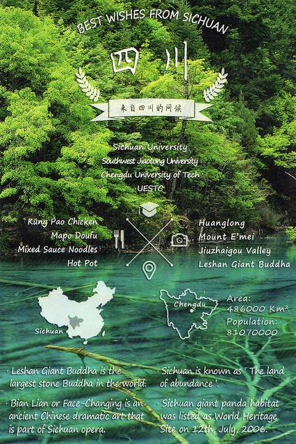
Best wishes from Sichuan, China
I'm not much into those fake "Greetings from" cards. Some of them look pretty cheap and nasty, some do actually look quite nice but I just don't like the idea of copying someone else's design. Why can't you come up with something original yourself??
I did make an exception for this one from China, I think this is really nice and not as bad a copy as most of the others.
I also like the fact that this card mentions Sichuan cuisine. The "real" dishes would probably be way too hot for me, but I like experimenting at home and actually make some Sichuan eggplant earlier today. Toban djan chilli bean sauce is sooo tasty, and I find Sichuan peppers kind of addictive. I really want to try make kung pao chicken at home too. It was lovely when I had it from one takeaway a couple of years ago, but after ordering it from somewhere else after that it wasn't the same at all. I don't even know how it's supposed to taste like...
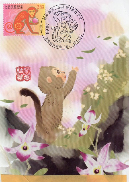
Happy Year of the Monkey!
A super cute Year of the Monkey maxi card I received from Taiwan :)
This is SO cute, and I love the special cancellation as well. Isn't it Chinese New Year this week?? I don't think I'll be celebrating, apart from having some vaguely Chinese food at home...
This is SO cute, and I love the special cancellation as well. Isn't it Chinese New Year this week?? I don't think I'll be celebrating, apart from having some vaguely Chinese food at home...
Labels:
2016,
chinese new year,
maxi cards,
RR,
taiwan,
year of the monkey
Greetings from Belarus
Today's 'Greetings from' card comes from Belarus. It's interesting, when I first joined Postcrossing, Belarus was a fairly "rare" country. You certainly can't say that anymore!
Haha, Belarus sounds a bit like Finland in that both countries have a lot of lakes and forests. :D I must admit, my knowledge of Belarus is still pretty limited and I'm not sure how accurate the picture I've got from reading newspapers/online articles is... Not sure what to say about this card... The colours make me feel really cold! :p
Haha, Belarus sounds a bit like Finland in that both countries have a lot of lakes and forests. :D I must admit, my knowledge of Belarus is still pretty limited and I'm not sure how accurate the picture I've got from reading newspapers/online articles is... Not sure what to say about this card... The colours make me feel really cold! :p
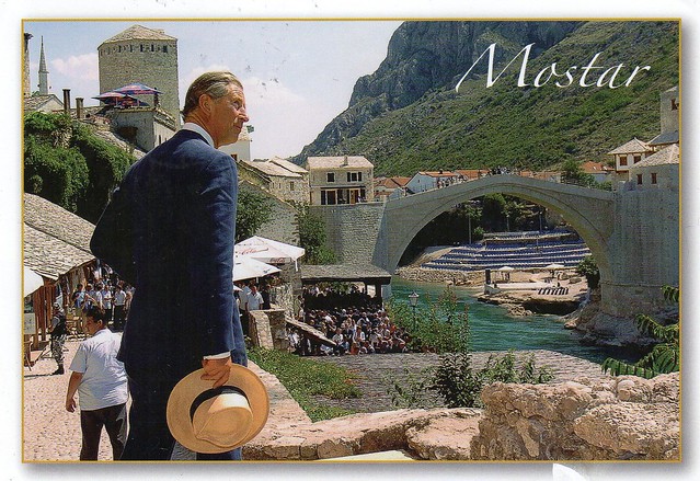
Mostar, Bosnia & Herzegovina
Another surprise postcard I received from Jobbo last year. A slightly different view of Mostar...
...I mean different in the sense that none of my other postcards of Mostar (and I have a LOT of them, thanks to dear Snježana) have Prince Charles on them. :P Why they would put him on a postcard like this is a little beyond me... I'm now also trying to work out what there is here behind the bridge - surely those blue (?) things are not sun loungers?!
I have yet to come across a postcard showing something other than the Old Bridge from Mostar. ...although perhaps that's not very surprising. Jobbo noted that the "new" or "normal" part of town is one of the poorest he's seen in Europe outside of Russia.
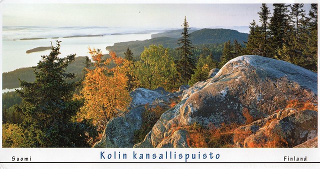
Koli National Park, Finland
This is a gorgeous, huge postcard, the scan doesn't do it justice. This is part of a stamp swap with Sini in Finland last year. The Finnish Post issued a stamp sheet about Finnish rock bands last year and it included some of my favourite bands - Nightwish and Apocalyptica. I'm not much into mint stamps so was really happy to receive the stamps on postcards (although sadly the one here didn't get cancelled, but that happens a LOT in Finland).
Koli National Park (Finnish: Kolin kansallispuisto) is a national park in the municipalities of Joensuu, Lieksa and Kontiolahti in the North Karelia region of Finland. It covers 30 square kilometres of forested hills on the western shore of Lake Pielinen, and was established in 1991. Contrary to the other national parks in Finland, Koli National Park was originally governed by the Finnish Forest Research Institute Metla. It is now governed by the Metsähallitus like the other national parks.
Koli has lots to offer cultural heritage-wise. Formerly, it was a sacrificial site, but was later used for slash-and-burn agriculture. The purpose of Koli National Park isn't to preserve wild nature, but the traditional agricultural heritage is cherished in Koli. Some fields are slashed, burnt and re-cultivated; hay is cut yearly. Traditional Finnish breeds of cow and sheep graze in the meadows of Koli.
Tuesday, 2 February 2016
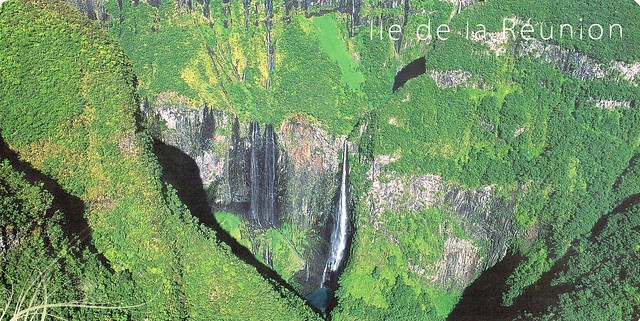
Réunion
One more card for today, and another new country to my collection! I never thought I'd ever get a postcard from Réunion. :O
Réunion is an insular region of France located in the Indian Ocean. It is situated east of Madagascar and about 175 kilometres southwest of Mauritius, the nearest island. As of 2014, its population numbered 844,994 inhabitants.
The island has been inhabited since the 17th century, when people from Europe (mostly France), Madagascar and Africa settled there. Slavery was abolished on 20 December 1848 (a date celebrated yearly on the island), after which indentured workers were brought from South India, among other places. The island became an overseas department of France in 1946.
The local language, spoken by the majority of the population, is Réunion Creole. The official language is French.
Administratively, Réunion is one of the overseas departments of France. Like the other four overseas departments, it is also one of the 18 regions of France, with the modified status of overseas regions, and an integral part of the Republic with the same status as those situated on the European mainland. Réunion is an outermost region of the European Union and, as an overseas department of France, a part of the Eurozone.
French stamps are used in Réunion.
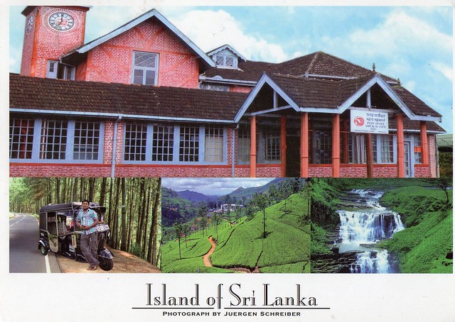
Post office in Nuwara Eliya, Sri Lanka
A lovely card I received through an Instagram swap last year. I love seeing pictures of post offices around the world but don't have too many on postcards so this is pretty special to me. ..and it's a pink post office as well!
Nuwara Eliya is a city, in the hill country of the Central Province, Sri Lanka. The city name meaning is "city on the plain (table land)" or "city of light". The city is the administrative capital of Nuwara Eliya District, with a picturesque landscape and temperate climate. It is located at an altitude of 1,868 m and is considered to be the most important location for tea production in Sri Lanka. The city is overlooked by Pidurutalagala, the tallest mountain in Sri Lanka. Nuwara Eliya is also known for the temperate, cool climate, the city is known for being the coolest area in Sri Lanka.
Nuwara Eliya is a city, in the hill country of the Central Province, Sri Lanka. The city name meaning is "city on the plain (table land)" or "city of light". The city is the administrative capital of Nuwara Eliya District, with a picturesque landscape and temperate climate. It is located at an altitude of 1,868 m and is considered to be the most important location for tea production in Sri Lanka. The city is overlooked by Pidurutalagala, the tallest mountain in Sri Lanka. Nuwara Eliya is also known for the temperate, cool climate, the city is known for being the coolest area in Sri Lanka.
Wood Buffalo National Park, Canada
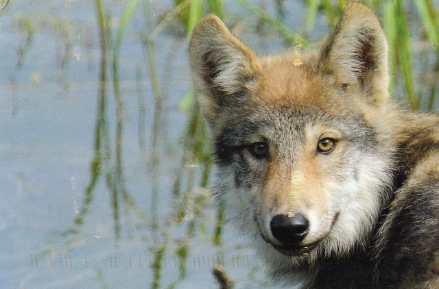
I only have a few Unesco cards from Canada so this is a very nice addition to my collection. ...and as an added bonus, it has a wolf on it!
Wood Buffalo National Park, located in northeastern Alberta and southern Northwest Territories, is the largest national park in Canada at 44,807 km2. Larger in area than Switzerland, it is the second-largest national park in the world, and thirteenth-largest protected area in the world. The park was established in 1922 to protect the world's largest herd of free roaming wood bison, currently estimated at more than 5,000. It is one of two known nesting sites of whooping cranes.
The park ranges in elevation from 183 m at the Little Buffalo River to 945 m in the Caribou Mountains. The park headquarters is located in Fort Smith, with a smaller satellite office in Fort Chipewyan, Alberta. The park contains one of the world's largest fresh water deltas, the Peace-Athabasca Delta, formed by the Peace, Athabasca and Birch Rivers. It is also known for its karst sinkholes in the north-eastern section of the park. Alberta's largest springs (by volume, with an estimated discharge rate of eight cubic meters per second), Neon Lake Springs, are located in the Jackfish River drainage. Wood Buffalo is located directly north of the Athabasca Oil Sands.
This area was designated a UNESCO World Heritage Site in 1983 for the biological diversity of the Peace-Athabasca Delta, one of the world's largest freshwater deltas, as well as the population of wild bison.
On June 28, 2013, the Royal Astronomical Society of Canada designated Wood Buffalo National Park as Canada's newest and the world's largest dark-sky preserve. Parks Canada claims that the designation will help preserve nighttime ecology for the park’s large populations of bats, night hawks and owls, as well as providing opportunities for visitors to experience the northern lights. The Wood Buffalo National Park had planned to celebrate the new designation with a Dark Sky Festival on August 23–25, 2013, featuring camping, astronomical presentations, a planetarium experience, and night sky viewing opportunities.
Bell Rock Lighthouse, Scotland
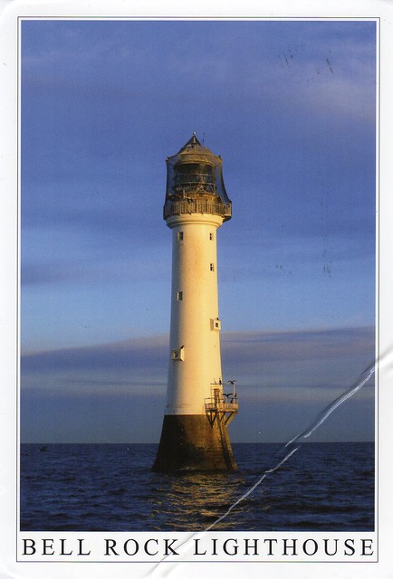
A lovely lighthouse postcard I received earlier this year through a Facebook swap. Iain kindly offered to send me a postcard with a new squirrel stamp. I can't get these Post & Go stamps anywhere near where I live, and the machines in the post office in Birmingham never have any of these nice pictorial stamps, they only ever seem to have the boring Queen's head ones. :( Thank you, Iain! It's just annoying that the postcard took a bit of a battering on its way down to England from Scotland.
The Bell Rock Lighthouse, off the coast of Angus, Scotland, is the world's oldest surviving sea-washed lighthouse. It was built between 1807 and 1810 by Robert Stevenson on the Bell Rock (also known as Inchcape) in the North Sea, 18 km east of the Firth of Tay. Standing 35 metres tall, its light is visible from 56 km inland.
The masonry work on which the lighthouse rests was constructed to such a high standard that it has not been replaced or adapted in 200 years. The lamps and reflectors were replaced in 1843 and used in the lighthouse at Cape Bonavista, Newfoundland, where they are currently on display. The working of the lighthouse has been automated since 1988.
The lighthouse operated in tandem with a shore station, the Bell Rock Signal Tower, built in 1813 at the mouth of Arbroath harbour. Today this building houses the Signal Tower Museum, a visitor centre detailing the history of the lighthouse.
The challenges faced in the building of the lighthouse have led to it being described as one of the Seven Wonders of the Industrial World.
Greetings from Serbia
A swap card from last year. I thought it was going to be really difficult to get this one, but I think I got lucky.. :)
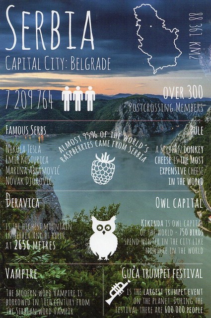
This is quite possibly one of my favourites in the 'greetings from' series. I like the darker colours here - I've probably said it a few times before but I'm not much into the pastel colours that are used in so many of these cards. I prefer something a little more realistic. :P That, and the view here is pretty amazing.
If anyone reading this knows why Serbia is such a massive producer of raspberries, please enlighten me, I'd love to know! I'm genuinely puzzled by this fact. Mmmmmm, raspberries.. I do love them!
It would be great to see the owl capital Kikinda one day, too. :)
Polish train
A random card from last year, received through Postcard United.
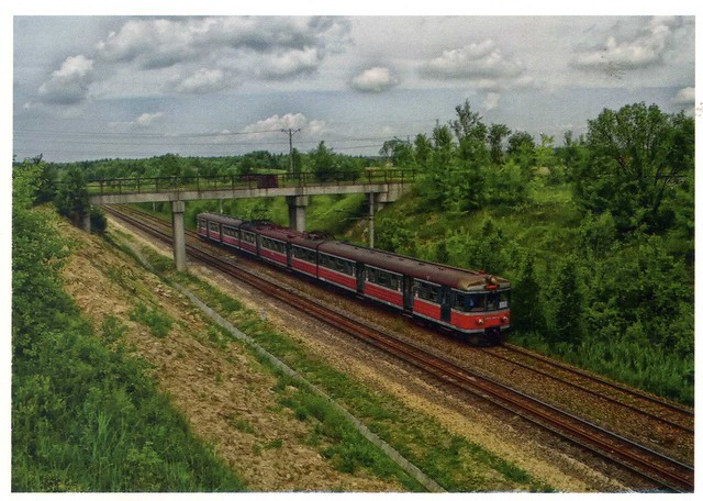
There is no information about the picture on the card so I have no idea what place this is or whether this train has any significance. I do think it's a nice picture, though. I haven't looked at the Postcard United website for months and months now. I thought they were really suspicious (how could they not be if you can't even delete your account or at least remove your contact details off the site?!) so haven't bothered since. I did receive some nice postcards through the site but I can do the same with Postcrossing.
There is no information about the picture on the card so I have no idea what place this is or whether this train has any significance. I do think it's a nice picture, though. I haven't looked at the Postcard United website for months and months now. I thought they were really suspicious (how could they not be if you can't even delete your account or at least remove your contact details off the site?!) so haven't bothered since. I did receive some nice postcards through the site but I can do the same with Postcrossing.
Subscribe to:
Comments (Atom)























 Maroon


