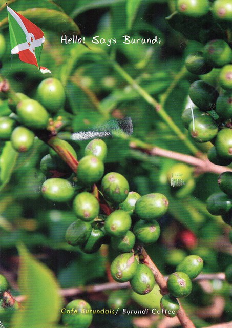
I don't get to add a new country to my postcard collection too often anymore. This is the most recent addition to that collection. I never really expected to receive a postcard from Burundi, so I was very happy to receive this one.
Burundi, officially the Republic of Burundi, is a landlocked country in the African Great Lakes region of East Africa, bordered by Rwanda to the north, Tanzania to the east and south, and the Democratic Republic of the Congo to the west. It is also sometimes considered part of Central Africa. Burundi's capital is Bujumbura. Although the country is landlocked, much of the southwestern border is adjacent to Lake Tanganyika.
The Twa, Hutu and Tutsi peoples have lived in Burundi for at least five hundred years. For more than 200 years, Burundi had an indigenous kingdom. At the beginning of the twentieth century, Germany colonized the region. After the First World War and Germany's defeat, it ceded the territory to Belgium. The Belgians ruled Burundi and Rwanda as a European colony known as Ruanda-Urundi. Their intervention exacerbated social differences between the Tutsi and Hutu, which contributed to political unrest in the region. There was civil war in Burundi as it fought for independence in the middle of the twentieth century. Presently, Burundi is governed as a presidential representative democratic republic.
Burundi is one of the five poorest countries in the world. It has one of the lowest per capita GDPs of any nation in the world. The country has suffered from warfare, corruption and poor access to education. Burundi is densely populated and has had substantial emigration as young people seek opportunities elsewhere. According to a 2012 DHL Global Connectedness Index, Burundi is the least globalized of 140 surveyed countries.
According to the Global Hunger Index of 2013, Burundi has an indicator ratio of 38.8, earning the nation the distinction of being the hungriest country in the world in terms of percentage.
Burundi's largest industry is agriculture, which accounted for just over 30% of the GDP. Subsistence agriculture accounts for 90% of agriculture. The nation's largest source of revenue is coffee, which makes up 93% of Burundi's exports. Other agricultural products include cotton, tea, maize, sorghum, sweet potatoes, bananas, manioc (tapioca); beef, milk, and hides. Foreign Policy reports, Subsistence farming is highly relied upon, however due to large population growth and no coherent policies governing land ownership, many people don't have the resources to sustain themselves. In 2014, the average farm size was about one acre.
Wednesday, 22 July 2015
Bangkok, Thailand
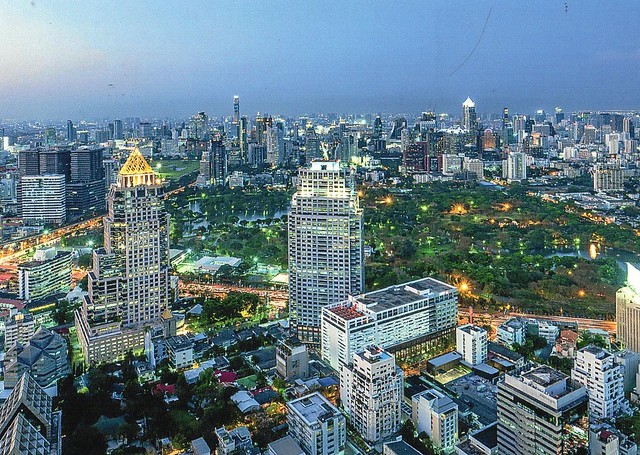
I've received two postcards from Bangkok, Thailand, from Jobbo, who emailed me a while back and very kindly offered to contribute to this blog. Thank you so very much, Jobbo, for being so generous! If you have a website I can link to, do let me know!
Bangkok is the capital and the most populous city of Thailand. It is known in Thai as Krung Thep Maha Nakhon or simply Krung Thep. The city occupies 1,568.7 square kilometres in the Chao Phraya River delta in Central Thailand, and has a population of over 8 million, or 12.6 percent of the country's population. Over 14 million people (22.2 percent) live within the surrounding Bangkok Metropolitan Region, making Bangkok an extreme primate city, dwarfing Thailand's other urban centres in terms of importance.
Bangkok traces its roots to a small trading post during the Ayutthaya Kingdom in the 15th century, which eventually grew in size and became the site of two capital cities: Thonburi in 1768 and Rattanakosin in 1782. Bangkok was at the heart of Siam's (as Thailand used to be known) modernization during the later 19th century, as the country faced pressures from the West. The city was the centre stage of Thailand's political struggles throughout the 20th century, as the country abolished absolute monarchy, adopted constitutional rule and underwent numerous coups and uprisings. The city grew rapidly during the 1960s through the 1980s and now exerts a significant impact among Thailand's politics, economy, education, media and modern society.
The Asian investment boom in the 1980s and 1990s led many multinational corporations to locate their regional headquarters in Bangkok. The city is now a major regional force in finance and business. It is an international hub for transport and health care, and is emerging as a regional centre for the arts, fashion and entertainment. The city is known for its vibrant street life and cultural landmarks, as well as its notorious red-light districts. The historic Grand Palace and Buddhist temples including Wat Arun and Wat Pho stand in contrast with other tourist attractions such as the nightlife scenes of Khaosan Road and Patpong. Bangkok is among the world's top tourist destinations. It is named the most visited city in MasterCard's Global Destination Cities Index, and was named "World's Best City" for four consecutive years by Travel + Leisure magazine.
Bangkok's rapid growth amidst little urban planning and regulation has resulted in a haphazard cityscape and inadequate infrastructure systems. Limited roads, despite an extensive expressway network, together with substantial private car usage, have resulted in chronic and crippling traffic congestion. This in turn caused severe air pollution in the 1990s. The city has since turned to public transport in an attempt to solve this major problem. Four rapid transit lines are now in operation, with more systems under construction or planned by the national government and the Bangkok Metropolitan Administration.
Greetings from Slovenia
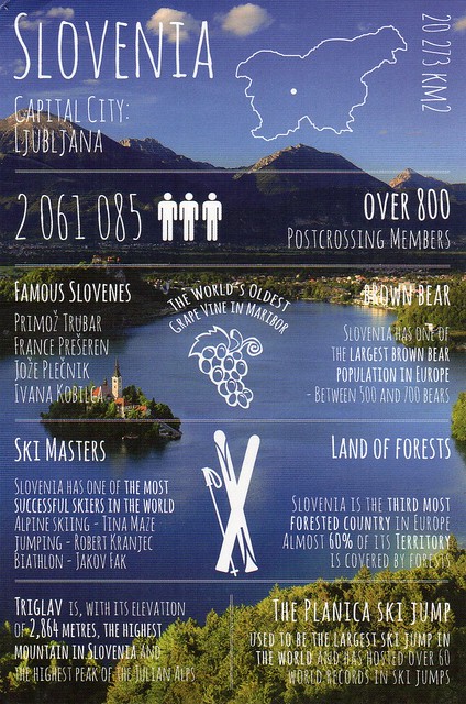
Today's 'greetings from' postcard comes from Slovenia. I actually ended up with two of these. :D Well, it IS very pretty, the views in Slovenia look pretty amazing!
So there will be new countries to the series again soon... I'm going to have to give up trying to get them all sent from country of origin; there's no way I could find anyone from Tajikistan, and probably not from Pakistan either. I mean, I don't have a single postcard from Tajikistan so far, so how likely would it be to get this one sent from there?? I'll just get a blank one I think...
Mateja, who sent back my card, pointed out that Slovenia is the only country in the world with the world 'love' in the name. I quite like that! :) The other copy I received is from a swap with Kristijan who tells me that there are at least 48 dialects and subdialects in 7 dialect groups in Slovenia. Pretty impressive! I wonder how difficult it is to understand the different dialects...?!
Srebarna Nature Reserve, Bulgaria
Another Unesco card, this time from Bulgaria.
The Srebarna Nature Reserve is a nature reserve in northeastern Bulgaria (Southern Dobruja), near the village of the same name, 18 km west of Silistra and 2 km south of the Danube. It comprises Lake Srebarna and its surroundings and is located on the Via Pontica, a bird migration route between Europe and Africa.
The Srebarna Nature Reserve is a freshwater lake adjacent to the Danube and extending over 600 ha. It is the breeding ground of almost 100 species of birds, many of which are rare or endangered. Some 80 other bird species migrate and seek refuge there every winter. Among the most interesting bird species are the Dalmatian pelican, great egret, night heron, purple heron, glossy ibis and white spoonbill.
Wooden Churches of Southern Małopolska, Poland
My Unesco collection has been growing slowly. This is one of the cards I've received this year.
The wooden churches of southern Little Poland represent outstanding examples of the different aspects of medieval church-building traditions in Roman Catholic culture. Built using the horizontal log technique, common in eastern and northern Europe since the Middle Ages, these churches were sponsored by noble families and became status symbols. They offered an alternative to the stone structures erected in urban centres. The churches are located in Gorlice, Nowy Targ, Bochnia counties (Lesser Poland Voivodeship or Małopolskie), and Brzozów County (Subcarpathian Voivodeship) and are in Binarowa, Blizne, Dębno, Haczów, Lipnica Dolna, and Sękowa.
The wooden church style of the region originated in the late Medieval, the late sixteenth century, and began with Gothic ornament and polychrome detail, but because they were timber construction, the structure, general form, and feeling is entirely different from the gothic architecture or Polish Gothic (in stone or brick). Later construction show Rococo and Baroque ornamental influence. The form of these Roman Catholic churches is deeply influenced by the Greco-Catholic and Orthodox presence in the region. Some display Greek cross plans and onion domes, but the most interesting of the churches combine these features with the Roman forms with elongated naves and steeples. Other collections of wooden churches of the region are in the open-air museums in Sanok and Nowy Sącz.
Joshua Tree National Park, USA
I'm getting so behind with this blog. ...and I can't see things improving very soon. I thought I'd update now that I have the time AND inspiration. To be fair, most of the time I'm just not very organised.. :P
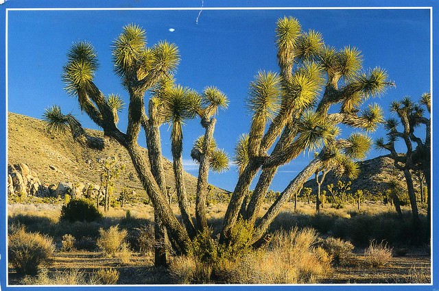
Today's first card is from the Vacation RR from earlier this year. I do have a bit of a soft spot for postcards showing national parks.
Joshua Tree National Park is located in southeastern California. Declared a U.S. National Park in 1994 when the U.S. Congress passed the California Desert Protection Act (Public Law 103-433), it had previously been a U.S. National Monument since 1936. It is named for the Joshua trees (Yucca brevifolia) native to the park. It covers a land area of 3,199.59 km2 – an area slightly larger than the state of Rhode Island. A large part of the park, some 173,890 ha, is a designated wilderness area. Straddling the San Bernardino County/Riverside County border, the park includes parts of two deserts, each an ecosystem whose characteristics are determined primarily by elevation: the higher Mojave Desert and lower Colorado Desert. The Little San Bernardino Mountains run through the southwest edge of the park.
Monday, 6 July 2015
Cultural Landscape of Honghe Hani Rice Terraces, China
I used to be fairly active in the 'You choose Unesco WHS' tag on the Postcrossing forum earlier this year but have had to take a break as postage is just ridiculous in the UK now. I can't afford to send too many postcards and friends take priority. Anyway, this is one of the cards I received through that tag. I really like this view, but find it a little odd that the sender didn't write any message on the back of the card. It literally only has my name, address and the name of the tag on. O_o Oh well, the sender must have had their reasons, and the card is still lovely.
The Cultural Landscape of Honghe Hani Rice Terraces, China covers 16,603-hectares in Southern Yunnan. It is marked by spectacular terraces that cascade down the slopes of the towering Ailao Mountains to the banks of the Hong River. Over the past 1,300 years, the Hani people have developed a complex system of channels to bring water from the forested mountaintops to the terraces. They have also created an integrated farming system that involves buffalos, cattle, ducks, fish and eel and supports the production of red rice, the area’s primary crop. The inhabitants worship the sun, moon, mountains, rivers, forests and other natural phenomena including fire. They live in 82 villages situated between the mountaintop forests and the terraces. The villages feature traditional thatched “mushroom” houses. The resilient land management system of the rice terraces demonstrates extraordinary harmony between people and their environment, both visually and ecologically, based on exceptional and long-standing social and religious structures.
The Cultural Landscape of Honghe Hani Rice Terraces, China covers 16,603-hectares in Southern Yunnan. It is marked by spectacular terraces that cascade down the slopes of the towering Ailao Mountains to the banks of the Hong River. Over the past 1,300 years, the Hani people have developed a complex system of channels to bring water from the forested mountaintops to the terraces. They have also created an integrated farming system that involves buffalos, cattle, ducks, fish and eel and supports the production of red rice, the area’s primary crop. The inhabitants worship the sun, moon, mountains, rivers, forests and other natural phenomena including fire. They live in 82 villages situated between the mountaintop forests and the terraces. The villages feature traditional thatched “mushroom” houses. The resilient land management system of the rice terraces demonstrates extraordinary harmony between people and their environment, both visually and ecologically, based on exceptional and long-standing social and religious structures.
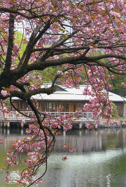
Hama Rikyu Gardens, Tokyo, Japan
A beautiful postcard from Japan from earlier this year. I'd love to get to see the cherry blossoms in Japan one day and experience 'hanami', it looks pretty amazing!
Hama Rikyu Gardens is a public park in Chūō, Tokyo, Japan. Located at the mouth of the Sumida River, it was opened April 1, 1946. The park is a 250,165 m² landscaped garden surrounding Shioiri Pond, the park itself surrounded by a seawater moat filled by Tokyo Bay. It was remodeled as a public garden park on the site of a villa of the Shogun Tokugawa family in the 17th century.
Japanese stamps are SO beautiful, and I love these special cancellations with pictures. I wish you could get nice cancellations in the UK as well... :/
Monterrey, Mexico
I don't get postcards from Mexico too often so I couldn't really refuse a swap request from there. Not sure if the view is one of my favourites, but it's still nice to have a postcard from this place.
Monterrey is the capital and largest city of the northeastern state of Nuevo León in the country of Mexico. The city is anchor to the third-largest metropolitan area in Mexico and is ranked as the ninth-largest city in the nation. Monterrey serves as a commercial center in the north of the country and is the base of many significant international corporations.
It is the second wealthiest city in Mexico and the ninth in Latin America with a GDP PPP of 130.7 billion dollars in 2012. Monterrey's GDP PPP per capita of 31,051 dollars is the highest in the country and second of Latin America. It is considered a Beta World City, cosmopolitan and competitive. Rich in history and culture, Monterrey is often regarded as the most "americanized" and developed city in the entire country, even above the cities along the U.S.-Mexico border.
As an important industrial and business center, the city is also home to an array of Mexican companies, including Grupo Avante, Lanix Electronics, Ocresa, CEMEX, Vitro, Mercedes-Benz Mexico, OXXO, BMW de Mexico, Grupo Bimbo, DINA S.A., Cuauhtémoc Moctezuma Brewery and Heineken, which features Norteño capital and Grupo ALFA. Monterrey is also home to international companies such as Accenture, Ternium, Sony, Toshiba, Carrier, Whirlpool, Samsung, Toyota, Daewoo, Ericsson, Nokia, Dell, Boeing, HTC, General Electric, Gamesa, LG, SAS Institute, Grundfos, Danfoss, and Teleperformance, among others.
Monterrey is located in northeast Mexico, at the foothills of the Sierra Madre Oriental. The uninterrupted settlement of Monterrey starts in 1596, with its founding by Diego de Montemayor. In the years after the Mexican War of Independence, Monterrey became an important business center. With the establishment of Fundidora Monterrey, the city experienced a great industrial growth.
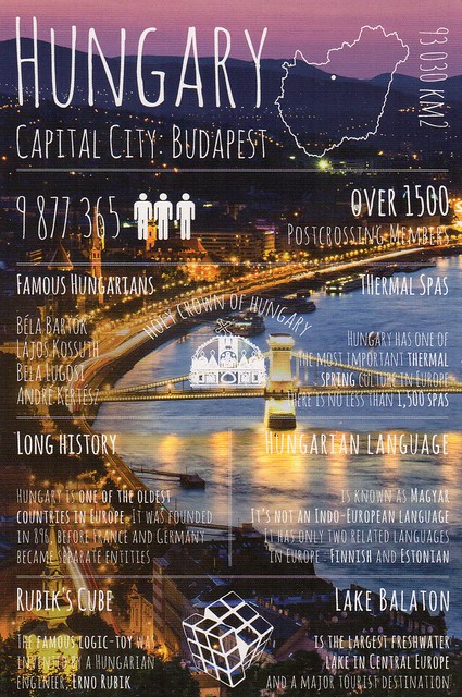
Greetings from Hungary
The 'greetings from' card of the day comes from Hungary. Thank you so much, Daniel! I was expecting it to be a lot harder to get this one.
I like the fairly strong colours here - I've got to admit the very pastel-coloured cards in this series aren't normally my favourites.
I was already aware of the fact that Hungarian is supposed to be related to Finnish, although I still don't really see how. I couldn't really understand a word of Hungarian. :P Apparently the tone is supposed to be similar, though.
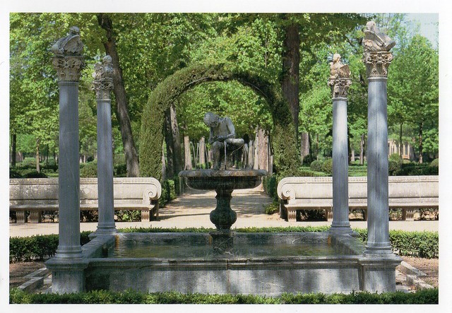
Aranjuez Cultural Landscape, Spain
A lovely Unesco card from Spain I received earlier this year.
The Aranjuez cultural landscape is an entity of complex relationships: between nature and human activity, between sinuous watercourses and geometric landscape design, between the rural and the urban, between forest landscape and the delicately modulated architecture of its palatial buildings. Three hundred years of royal attention to the development and care of this landscape have seen it express an evolution of concepts from humanism and political centralization, to characteristics such as those found in its 18th century French-style Baroque garden, to the urban lifestyle which developed alongside the sciences of plant acclimatization and stock-breeding during the Age of Enlightenment.
Aranjuez cultural landscape is located in the Province and Autonomous Community of Madrid.
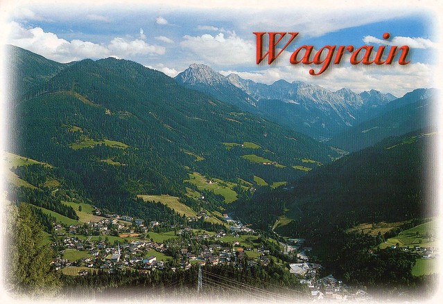
Wagrain, Austria
Long time no see... I wasn't intending on taking this long to update again but somehow it just happened. Well, there *was* quite a lot going on in June and I've been preoccupied with other things. I'll try to squeeze in an update now before heading off to my aikido class.
This card is from a swap earlier this year. Marco was offering the new Austrian Europa stamp and I just couldn't resist. Marco accidentally sent me a cover with the stamp first but kindly offered to send a postcard as well as that's what we'd agreed on. He did do a lot of swaps for the stamp, though! Anyway.. I was getting frustrated with the cover I sent to him - it was returned to me TWICE by the Royal Mail despite the postage actually being too much! It did finally reach Austria, but I was getting a little annoyed. The same happened shortly afterwards with a letter I sent to dad's sister. I wonder if it happened because of the way I write (or used to, I've changed it a little since then) the return address on the back of the envelope? Oh, the joys of sorting machines. :P ...although I find it a bit strange that the postman didn't notice anything! Or maybe he did but just doesn't care...
Wagrain is a market town in the St. Johann im Pongau District in the Austrian state of Salzburg. It is located in a high valley stretching from the Salzach at Sankt Johann in the west to the Enns river in the east. The municipality includes the Katastralgemeinden Hof, Hofmarkt, Schwaighof and Vorderkleinarl. The population is about 3,020.
The settlement of Wakrein in the Archbishopric of Salzburg was first mentioned in a 1243 deed. Original a mining area, Wagrain in the early 18th century was a centre of Crypto-protestantism within the Catholic country. About 1732/33 Prince-Archbishop Count Leopold Anton von Firmian had the Protestant population expelled; most were received by King Frederick William I of Prussia and re-settled the East Prussian province, which had been devastated by the plague.
Today Wagrain mainly depends on tourism. It is nestled in the valley of the Ski Amadé resorts, one of the largest ski resort networks in Europe. In the summer the ski lifts transport bikers to the mountains for the summer mountain biking season.
Wagrain is the original home of Atomic Skis, which was founded in 1955 by Alois Rohrmoser, who bought a wheelwright shop, and expanded its production to include winter sports equipment, such as skis and sleds, using local timber resources and a crew of four craftsmen.
Subscribe to:
Comments (Atom)












 Maroon


