Most of my postcards from Vietnam depict scenes of everyday life - markets, people... I do love those and wish similar postcards were available here as well, but it was still a treat to receive something slightly different. I love this cityview, it looks so vibrant, and the colours are gorgeous I think. The scan doesn't do the colours justice. :/
Ho Chi Minh City, formerly named Saigon, is the largest city in Vietnam. It was once known as Prey Nokor, an important Khmer sea port prior to annexation by the Vietnamese in the 17th century. Under the name Saigon, it was the capital of the French colony of Cochinchina and later of the independent republic of South Vietnam 1955–75. On 2 July 1976, Saigon merged with the surrounding Gia Định Province and was officially renamed Ho Chi Minh City after Hồ Chí Minh (although the name Sài Gòn is still unofficially widely used).
The metropolitan area, which consists of the Ho Chi Minh City metropolitan area, Thủ Dầu Một, Dĩ An, Biên Hòa and surrounding towns, is populated by more than 9 million people, making it the most populous metropolitan area in Vietnam. The city's population is expected to grow to 13.9 million in 2025.
The Ho Chi Minh City Metropolitan Area, a metropolitan area covering most parts of the Southeast region plus Tiền Giang Province and Long An Province under planning, will have an area of 30,000 square kilometres with a population of 20 million inhabitants by 2020. According to the Mercer Human Resource Consulting, Economist Intelligence Unit and ECA International, Ho Chi Minh City is ranked 132 on the list of world's most expensive cities for expatriate employees.
Monday, 8 June 2015
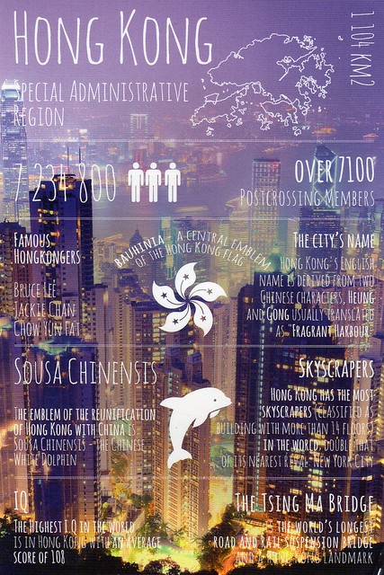
Greetings from Hong Kong
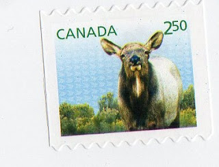
I was obviously not very organised with this one - somehow I ended up with four of these! :O I'll have to be more careful in the future...! Well, there are some very nice stamps on the cards, I've picked a couple to include in this post.
The background of this card shows the Victoria Harbour. I was also pointed out that the Chinese White Dolphin mentioned on this card is not actually white - they are grey when young and pink when mature. I'm not sure if I had even heard of them before...!
I've got a bit of a soft spot for Hong Kong as my friend Miranda is from there, so I've been curious about the place ever since I first met her. Incidentally, she'll be going to Hong Kong for a couple of weeks soon - I'm looking forward to seeing her photos on Facebook again. :) I'd love to visit Hong Kong myself one day, too, it seems like a really interesting city.
Calgary Postcrossing meet-up, Canada
I wish there were Postcrossing meet-ups a little closer to where I live - at the moment they all seem to take place in London. :/ I guess there around many active Postcrossers in the Midlands... Anyway, this could well be my first Postcrossing meet-up card from Canada. I do like it when there are special postcards printed just for these events.
Calgary is a city in the province of Alberta, Canada. It is situated at the confluence of the Bow River and the Elbow River in the south of the province, in an area of foothills and prairie, approximately 80 km east of the front ranges of the Canadian Rockies. In the 2011 census, the City of Calgary had a population of 1,096,833 and a metropolitan population of 1,214,839, making it the largest city in Alberta, and the third-largest municipality and fifth-largest census metropolitan area (CMA) in Canada.
The economy of Calgary includes activity in the energy, financial services, film and television, transportation and logistics, technology, manufacturing, aerospace, health and wellness, retail, and tourism sectors. The Calgary CMA is home to the second-most corporate head offices in Canada among the country's 800 largest corporations.
Calgary anchors the south end of what Statistics Canada defines as the "Calgary–Edmonton Corridor".
In 1988, Calgary became the first Canadian city to host the Olympic Winter Games.
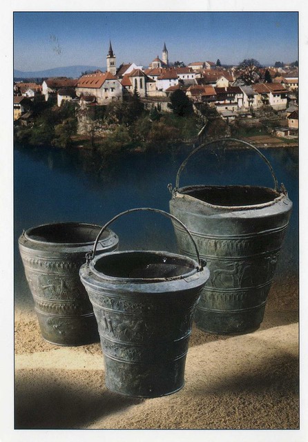
Novo Mesto, Slovenia
This is from a swap from earlier this year. I was so happy when Mateja offered to send me the Slovenian Year of the Sheep/Goat stamp. :) I do still miss quite a few countries in my Year of the Sheep stamp collection, but it's pretty decent anyway.
Novo Mesto is the city on a bend of the Krka River in the City Municipality of Novo Mesto in southeastern Slovenia, close to the border with Croatia. The town is traditionally considered the economic and cultural centre of the historical Lower Carniola region.
Today, tourism is increasing in Slovenia, and Novo Mesto is feeling some of the effects. The Krka Valley is becoming a place for wine enthusiasts who take tours throughout the Lower Carniola region, tasting locally produced Cviček wine, which is produced by blending several different varieties of local wine.
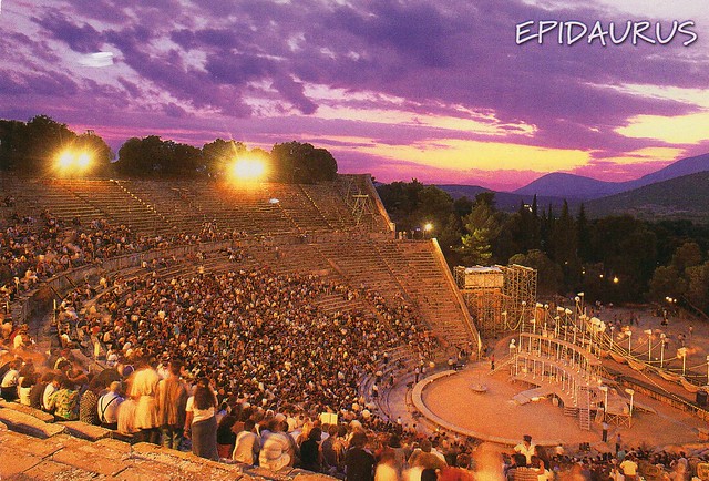
Sanctuary of Asklepios at Epidaurus, Greece
I've been working on my Unesco postcard collection a little lately and have received some very nice new additions to my collection. This is one of them, received earlier this year. Thank you so much, Elena!
In a small valley in the Peloponnesus, the shrine of Asklepios, the god of medicine, developed out of a much earlier cult of Apollo (Maleatas), during the 6th century BC at the latest, as the official cult of the city state of Epidaurus. Its principal monuments, particularly the temple of Asklepios, the Tholos and the Theatre - considered one of the purest masterpieces of Greek architecture – date from the 4th century. The vast site, with its temples and hospital buildings devoted to its healing gods, provides valuable insight into the healing cults of Greek and Roman times.
In a small valley in the Peloponnesus, the shrine of Asklepios, the god of medicine, developed out of a much earlier cult of Apollo (Maleatas), during the 6th century BC at the latest, as the official cult of the city state of Epidaurus. Its principal monuments, particularly the temple of Asklepios, the Tholos and the Theatre - considered one of the purest masterpieces of Greek architecture – date from the 4th century. The vast site, with its temples and hospital buildings devoted to its healing gods, provides valuable insight into the healing cults of Greek and Roman times.
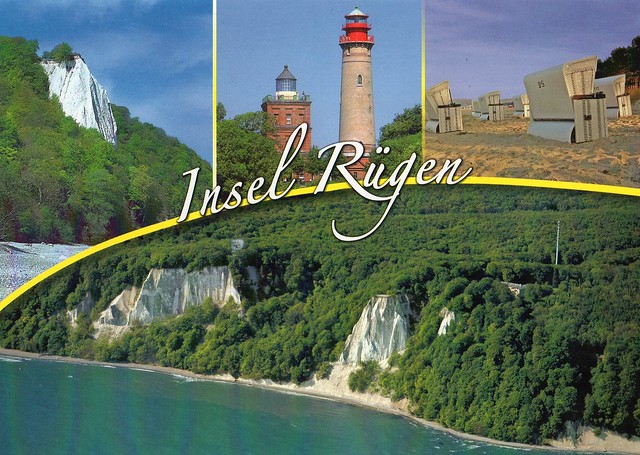
Rügen Island, Germany
One of the nicer multiviews I've received from Germany! I actually like this one quite a bit.
Rügen is Germany's largest island by area. It is located off the Pomeranian coast in the Baltic Sea and belongs to the state of Mecklenburg-Western Pomerania.
The "gateway" to Rügen island is the Hanseatic city of Stralsund, where it is linked to the mainland by road and railway via the Rügen Bridge and Causeway, two routes crossing the two-kilometre-wide Strelasund, a sound of the Baltic Sea.
Rügen has a maximum length of 51.4 km (from north to south), a maximum width of 42.8 km in the south and an area of 926 km². The coast is characterized by numerous sandy beaches, lagoons (Bodden) and open bays (Wieke), as well as projecting peninsulas and headlands. In June 2011, UNESCO awarded the status of a World Heritage Site to the Jasmund National Park, famous for its vast stands of beeches and chalk cliffs like King's Chair, the main landmark of Rügen island.
The island of Rügen is part of the district of Vorpommern-Rügen, with its county seat in Stralsund. The towns on Rügen are: Bergen, Sassnitz, Putbus and Garz. In addition, there are the Baltic seaside resorts of Binz, Baabe, Göhren, Sellin and Thiessow.
Rügen is very popular as a tourist destination because of its resort architecture, the diverse landscape and its long, sandy beaches.
Labels:
2015,
germany,
islands,
lighthouses,
national parks,
RR,
rügen,
unesco
Monday, 1 June 2015
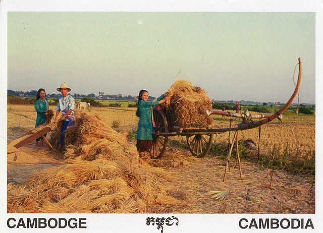
Cambodia
Another Facebook swap from earlier this year... Again, I don't have too many postcards from Cambodia and I think I've only received one written and stamped postcard from there before, in 2009 (which, weirdly enough, was an official Postcrossing card!). Anyway, Nina went on a holiday in Cambodia and offered to send a postcard. :) Thank you ever so much!
Agriculture is the traditional mainstay of the Cambodian economy. Agriculture accounted for 90 percent of GDP in 1985 and employed approximately 80 percent of the work force. Rice is the principal commodity.
Agriculture is the traditional mainstay of the Cambodian economy. Agriculture accounted for 90 percent of GDP in 1985 and employed approximately 80 percent of the work force. Rice is the principal commodity.
Constantine, Algeria
I think this is only about my second postcard from Algeria.. ...which is the main reason I couldn't really say 'no' when I was asked if I'd like to swap. Well, and it is a pretty nice view as well.
Constantine is the capital of Constantine Province in north-eastern Algeria. During Roman times it was called Cirta and was renamed "Constantina" in honor of emperor Constantine the Great. It was the capital of the same-named French département until 1962. Slightly inland, it is about 80 kilometres from the Mediterranean coast, on the banks of the Rhumel river.
Regarded as the capital of eastern Algeria and the centre of its region, Constantine has a population of 448,374 (1,000,000 with the agglomeration), making it the third largest city in the country after Algiers and Oran. There are museums and important historical sites around the city (one of the most beautiful is the Palais du Bey, in the casbah).
It is often referred to as the "City of Bridges" due to the numerous picturesque bridges connecting the mountains the city is built on.
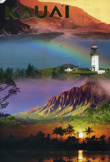
Kaua'i, Hawaii, USA
A postcard I received through an Instagram swap a couple of years ago. Hawaii looks so dreamy!
Kauaʻi is geologically the oldest of the main Hawaiian Islands. With an area of 1,456.4 km2, it is the fourth largest of the main islands in the Hawaiian archipelago, and the 21st largest island in the United States. Known also as the "Garden Isle", Kauaʻi lies 169 km across the Kauaʻi Channel, northwest of Oʻahu. This island is the site of Waimea Canyon State Park.
The United States Census Bureau defines Kauaʻi as Census Tracts 401 through 409 of Kauaʻi County, Hawaiʻi, which is all of the county except for the islands of Kaʻula, Lehua, and Niʻihau. The 2010 census population of Kauaʻi (the island) was 67,091, with the largest town by population being Kapaʻa.
Greetings from the Netherlands
This was one of the first Greetings from postcards I received, but for some reason it's taken me this long to post it here. That's not to say I don't like it, although I do prefer the not so pastel-coloured cards in the series...
I used to receive a LOT of postcards from the Netherlands but that's changed somewhat in the last year or so. I'm happy I'm still in touch with Astrid, though, it's always lovely to hear from her! What to say about this card? Amsterdam is one of those cities I'd really love to visit. It looks so nice, and it's supposed to be a lovely place to visit..?! I'd love to see the canals and all the bicycles!
I used to receive a LOT of postcards from the Netherlands but that's changed somewhat in the last year or so. I'm happy I'm still in touch with Astrid, though, it's always lovely to hear from her! What to say about this card? Amsterdam is one of those cities I'd really love to visit. It looks so nice, and it's supposed to be a lovely place to visit..?! I'd love to see the canals and all the bicycles!
Finland
A slightly older card for a change... I was supposed to become postcard pals with the girl who sent me this card, but I only ever received this one postcard from her and never heard from her again. At least it's a very nice card.. :)
I have no idea where in Finland this image was taken, there is no description whatsoever on the card. This could be anywhere... I've really started to enjoy views like this after moving to England. I guess I do get a little homesick at times...
I have no idea where in Finland this image was taken, there is no description whatsoever on the card. This could be anywhere... I've really started to enjoy views like this after moving to England. I guess I do get a little homesick at times...
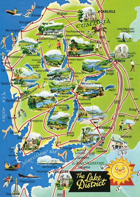
The Lake District, England
At the start of May I was contacted by a Postcrosser who told me she'd heard that for a few days, all mail sent in the UK would be cancelled with a special 'Royal Baby' postmark and asked me if I could send her a postcard. I'm not really interested in the Royal family but I thought the special cancellation would still be nice, so I sent myself a couple of postcards as well. Well, both were actually cancelled, which is quite impressive in itself, but it was just a regular cancellation, nothing to do with the royal baby. The Postcrosser told me she got the cancellation, but that it was really unclear. Lovely work, the Royal Mail... :/
One of the cards I sent to myself was this map of the Lake District. I'm actually going to be there next month as my husband's older brother will be getting married there. I have no idea where exactly, though, as no one has bothered to tell me. :P (EDIT: It'll be somewhere near Windermere.) I do hope I'll get to explore the area at least a little bit as it's supposed to be really beautiful up there. I wouldn't say no to getting to buy some postcards, either... :P The Lake District is also a tentative Unesco site.
The Lake District, also known as The Lakes or Lakeland, is a mountainous region in North West England. A popular holiday destination, it is famous for its lakes, forests and mountains (or fells) and its associations with the early 19th-century writings of William Wordsworth and the other Lake Poets.
Historically split between Cumberland, Westmorland and Lancashire, the Lake District is now entirely in Cumbria. All the land in England higher than three thousand feet (914.4 m) above sea level lies within the National Park, including Scafell Pike, the highest mountain in England. It also contains the deepest and longest lakes in England, Wastwater and Windermere.
Labels:
2015,
england,
maps,
the lake district,
unesco tentative
Iwate, Japan
Ooops. I've been neglecting this blog again, which certainly wasn't my intention this time. I blame my terrible procrastination tendencies as I don't have any proper excuses for not updating. I'm rubbish at time management :/ ...and May just disappeared somewhere, which is a little scary. My pile of postcards for this blog has grown again - I did have it to a more manageable level at one point.. *sigh*
Today's first card is from a swap with Sayaka in Japan earlier this year, an addition to my still tiny Gotochi collection.
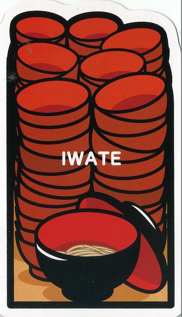
This card shows 'wanko-soba', an Iwate special. Sayaka tells me it's a very small amount of soba each, but the serving lady is always beside you and once she sees you finished one, she tries to serve one cup of soba more. ...repeat, repeat and repeat, and it's really quick, so it is also hard to act "I'm full". If you want to finish, you have to cover the cup but it's really difficult because the serving lady is really really quick. Sounds interesting... I do like soba, but have never had them this way.
Subscribe to:
Comments (Atom)














 Maroon


