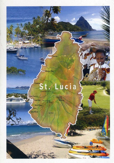
Saint Lucia is an island country in the eastern Caribbean Sea on the boundary with the Atlantic Ocean. Part of the Lesser Antilles, it is located north/northeast of the island of Saint Vincent, northwest of Barbados and south of Martinique. It covers a land area of 620 km2 and has an estimated population of 173,765 (2009 census).
The volcanic island of Saint Lucia is more mountainous than many other Caribbean islands, with the highest point being Mount Gimie, at 950 metres (3,120 ft) above sea level. Two other mountains, the Pitons (also a Unesco World Heritage Site, pictured on this card in the top right corner), form the island's most famous landmark. They are located between Soufrière and Choiseul on the western side of the island. Saint Lucia is also one of the few islands in the world that boasts a drive-in volcano.
The capital city of Saint Lucia is Castries, where about one third of the population lives. Major towns include Gros Islet, Soufrière and Vieux Fort. The local climate is tropical, moderated by northeast trade winds, with a dry season from December 1 to May 31, and a wet season from June 1 to November 30.

The stamp is from a set of 14 definitives issued in 2005, depicting fruits. This one here is Breadfruit.


 Maroon


")


