Wednesday 4 July 2012

Patan Durbar Square, Lalitpur, Nepal

One more card for today.. This one was SUCH a surprise, too - I never expected to receive an official Postcrossing card from Nepal as it's such a small country with just a few users and not that many cards sent (the postcard ID on this one is so small!). Looks like I can be lucky sometimes as well, then?! :) Not only is this my first received written and stamped postcard from Nepal, it's also a really lovely view - I love market scenes like this, it's nice to see pictures of ordinary life in different parts of the world.

NP-346

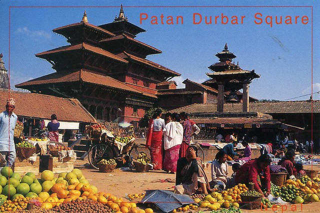
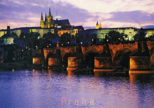
Patan Durbar Square is situated at the centre of Lalitpur city. It is one of the three Durbar Squares in the Kathmandu Valley, all of which are UNESCO World Heritage Sites. One of its attraction is The Ancient Royal Palace where Malla Kings of Lalitpur resided.

Lalitpur (officially Lalitpur Sub-Metropolitan City, also called Patan) is one of the major cities of Nepal located in the south-central part of Kathmandu Valley. Patan is also known as Manigal. It is best known for its rich cultural heritage, particularly its tradition of arts and crafts. It is also called as city of festival and feast, fine ancient art, making of metallic and stone carving statue. At the time of the 2001 Nepal census it had a population of 162,991 in 68,922 individual households.

Nepal is a landlocked sovereign state located in South Asia. It has an area of 147,181 square kilometres and a population of approximately 27 million (and 2 million absentee workers living abroad). It is located in the Himalayas and bordered to the north by the People's Republic of China, and to the south, east, and west by the Republic of India, while across the Himalayas lies the Tibetan Autonomous Region. Kathmandu is the nation's capital and the country's largest metropolis. Kathmandu Valley itself has estimated population of 5 million.

Nepal has a rich geography. The mountainous north has eight of the world's ten tallest mountains, including the highest point on Earth, Mount Everest, called Sagarmatha in Nepali. It contains more than 240 peaks over 6,096 m above sea level. The fertile and humid south is heavily urbanized.

Hinduism is practised by about 81% of Nepalese - making it the country with the highest percentage of Hindu followers. Buddhism, though a minority faith in the country, is linked historically with Nepal.

A monarchy throughout most of its history, Nepal was ruled by the Shah dynasty of kings from 1768, when Prithvi Narayan Shah unified its many small kingdoms. However, a decade-long Civil War by the Communist Party of Nepal (Maoist) and several weeks of mass protests by all major political parties led to the 12 point agreement of November 22, 2005. The ensuing elections for the constituent assembly on May 28, 2008 overwhelmingly favored the abdication of the Nepali monarch Gyanendra Shah and the establishment of a federal multiparty representative democratic republic.

Sultan Mosque, Singapore

Moving on to one of Malaysia's neighbours, Singapore. I opened a thread on the Postcrossing forum earlier this year looking for postcards from my favourites albums, and this is one of those cards. Such a pretty view! Mmmm, and I think I should try getting more active with that thread again after I come back from Finland, it's been so much fun!


Sultan Mosque; is located at Muscat Street and North Bridge Road within the Kampong Glam district of Rochor Planning Area in Singapore. The mosque is considered one of the most important mosques in Singapore. The prayer hall and domes highlight the mosque's star features. Sultan Mosque has stayed essentially unchanged since it was built in the 19th century, with only repairs carried out to the main hall in the 1960s and an annex added in 1993. It was gazetted as a national monument on 14 March 1975.

Penang, Malaysia

My selection of postcards for today is quite a random mix - now moving on to Asia, namely Malaysia. I received this postcard from a tag earlier this year and simply adore it, it's such a colourful card with lots of fascinating little details. ...and it's a Unesco site as well!


Penang is a state in Malaysia and the name of its constituent island, located on the northwest coast of Peninsular Malaysia by the Strait of Malacca. It is bordered by Kedah in the north and east, and Perak in the south. Penang is the second smallest Malaysian state in area after Perlis, and the eighth most populous. It is composed of two parts – Penang Island, where the seat of government is, and Seberang Perai (formerly, and occasionally Province Wellesley) on the Malay Peninsula. Highly urbanised and industrialised Penang is one of the most developed and economically important states in the country, as well as a thriving tourist destination. Its heterogeneous population is highly diverse in ethnicity, culture, language, and confessions. A resident of Penang is colloquially known as a Penangite.

On this postcard you can see the Kek Lok Si Temple, a Buddhist temple situated in Air Itam in Penang and one of the best known temples on the island. The temple is heavily commercialised with shops at every level and inside the main temple complexes. Mahayana Buddhism and traditional Chinese rituals blend into a harmonious whole, both in the temple architecture and artwork as well as in the daily activities of worshippers.

Texas, USA

Moving on... across the Atlantic to the USA. I received this lovely mapcard in one of my favourite RR's, 'Choose a Country', earlier this year. I had actually had this postcard in my favourites for a while so I'm really happy to have a copy now :)


Texas is the second most populous and the second most extensive of the 50 states in the United States of America, and the most extensive state of the 48 contiguous United States. The name, based on the Caddo word tejas meaning "friends" or "allies", was applied by the Spanish to the Caddo themselves and to the region of their settlement in East Texas. Located in the South Central United States, Texas shares an international border with the Mexican states of Chihuahua, Coahuila, Nuevo León, and Tamaulipas to the south, and borders the US states of New Mexico to the west, Oklahoma to the north, Arkansas to the northeast, and Louisiana to the east. Texas has an area of 696,200 km, and a growing population of 25.7 million residents.

Houston is the largest city in Texas and the fourth-largest in the United States, while San Antonio is the second largest in the state and seventh largest in the United States. Dallas–Fort Worth and Greater Houston are the fourth and fifth largest United States metropolitan areas, respectively. Other major cities include El Paso and Austin—the state capital. Texas is nicknamed the Lone Star State to signify Texas as a former independent republic and as a reminder of the state's struggle for independence from Mexico. The "Lone Star" can be found on the Texas state flag and on the Texas state seal today.

Due to its size and geologic features such as the Balcones Fault, Texas contains diverse landscapes that resemble both the American South and Southwest. Although Texas is popularly associated with the Southwestern deserts, less than 10% of the land area is desert. Most of the population centers are located in areas of former prairies, grasslands, forests, and the coastline. Traveling from east to west, one can observe terrain that ranges from coastal swamps and piney woods, to rolling plains and rugged hills, and finally the desert and mountains of the Big Bend.

The term "six flags over Texas" came from the several nations that had ruled over the territory. Spain was the first European country to claim the area of Texas. France held a short-lived colony in Texas. Mexico controlled the territory until 1836 when Texas won its independence, becoming an independent Republic. In 1845 it joined the United States as the 28th state. The state's annexation set off a chain of events that caused the Mexican–American War in 1846. A slave state, Texas declared its secession from the United States in early 1861, joining the Confederate States of America during the American Civil War. After the war and its restoration to the Union, Texas entered a long period of economic stagnation.

One Texas industry that thrived after the Civil War was cattle. Due to its long history as a center of the industry, Texas is associated with the image of the cowboy. The state's economic fortunes changed in the early 20th century, when oil discoveries initiated an economic boom in the state. With strong investments in universities, Texas developed a diversified economy and high tech industry in the mid-20th century. As of 2010 it shares the top of the list of the most Fortune 500 companies with California at 57. With a growing base of industry, the state leads in many industries, including agriculture, petrochemicals, energy, computers and electronics, aerospace, and biomedical sciences. It leads the nation in export revenue since 2002 and has the second-highest gross state product.

Blitvenica, Croatia

This lovely lighthouse postcard is from an ongoing swap with dear Agi. I just love this card, the gorgeously blue sea and the matching stamp on the card :)


I couldn't find any info about the place, Blitvenica, except that it's an uninhabited island on the Dalmatian coast. This lighthouse seems pretty isolated...


Agi used a lighthouse stamp on the card! :)

Prague, Czech Republic

I thought I'd try to distract myself by updating this blog... I've got my Aikido black belt exam this weekend and I'm getting REALLY nervous (although thankfully I haven't thrown up so far :P)
Postcard therapy?! Haha. :P I'm going to be SO relieved when that grading is over..! Fingers crossed it'll go well, too. Next Monday, the day after the exam, me and Matt will be off to Finland for a week to see my family. I'm really looking forward to seeing my parents and sister again, and everyone else, too. ..hehe, and I'm hoping to send some postcards to people from there as well. ;)

Speaking of family, my parents visited Prague last week. (My sister told them they should go on holiday somewhere else than to the caravan site where they always go :D) They really enjoyed it there and it sounded great, I can't wait to see the photos they took. They sent me a postcard from Prague as well, it's the bottom one (the clock) here. The first one is from my Belarusian postcard pal Katya who was also on holiday in Prague recently. *jealous*


Prague is the capital and largest city of the Czech Republic and fourteenth largest city in the European Union. Situated in the north-west of the country on the Vltava river, the city is home to about 1.3 million people, while its metropolitan area is estimated to have a population of nearly 2.0 million. The city has a temperate oceanic climate with warm summers and chilly winters.

Prague has been a political, cultural, and economic centre of central Europe with waxing and waning fortunes during its 1,100 year existence. Founded during the Romanesque and flourishing by the Gothic and Renaissance eras, Prague was the seat of two Holy Roman Emperors and thus then also the capital of the Holy Roman Empire. It was an important city to the Habsburg Monarchy and its Austro-Hungarian Empire and after World War I became the capital of Czechoslovakia. The city played major roles in the Protestant Reformation, the Thirty Years' War, and in modern history generally as the principal conurbation in Bohemia and Moravia whose second city is Brno.

 Prague is home to a number of famous cultural attractions, many of which survived the violence and destruction of twentieth century Europe. Main attractions include the following: Prague Castle, the Charles Bridge, Old Town Square, the Jewish Quarter, the Lennon Wall, and Petřín hill. Since 1992, the extensive historic centre of Prague has been included in the UNESCO list of World Heritage Sites.


Prague Astronomical Clock  is a medieval astronomical clock, mounted on the southern wall of Old Town City Hall in the Old Town Square. The clock was first installed in 1410, making it the third-oldest astronomical clock in the world and the oldest one still working. The clock mechanism itself is composed of three main components: the astronomical dial, representing the position of the Sun and Moon in the sky and displaying various astronomical details; "The Walk of the Apostles", a clockwork hourly show of figures of the Apostles and other moving sculptures—notably a figure of Death (represented by a skeleton) striking the time; and a calendar dial with medallions representing the months.


My parents and Katya both used the same stamp so I'm only uploading one picture here.