Wednesday 27 June 2012

Tórshavn, Faroe Islands

Life is funny sometimes. For the longest time I didn't have any postcards of the Faroe Islands. Then I bought a pack from ebay, but didn't think I'd ever actually receive a written and stamped postcard from there. ...and then last week I received two! One of them I was actually expecting as I had managed to reserve a seat in a Faroe Islands group in the 'Vacation RR' on the Postcrossing forum, but the first one (and the one you can see in this post) I received was a complete, total surprise. It's from my friend Johanna from her holiday. She's been to some pretty exotic places: Greenland, Mongolia... and now the Faroe Islands!


Tórshavn is the capital and largest town of the Faroe Islands. It is located in the southern part on the east coast of Streymoy. To the north west of the town lies the 347-metre high mountain Húsareyn, and to the southwest, the 350-metre high Kirkjubøreyn. The city proper has a population of 13,000 (2008), and the greater urban area a population of 19,000.

The Vikings established their parliament on the Tinganes peninsula in 850 CE, thus Tórshavn was made capital of Faroe Islands and has remained so ever since. All through the Middle Ages the narrow peninsula jutting out into the sea made up the main part of Tórshavn. Sources do not mention a built-up area in Tórshavn until after the Protestant Reformation in 1539. Early on, Tórshavn became the center of the monopoly trade, thereby being the only legal place for the islanders to sell and buy goods. In 1856, the trade monopoly was abolished and the islands were left open to free trade. The town has grown rapidly ever since the turn of the 20th century into the undisputed administrative, economic and cultural center of the Faroes.


...and Johanna found me the new Faroese Europa stamp! *squeee*

Berlin, Germany

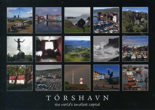
I only just realised that I don't have any postcards of Berlin in this blog. How did that happen?! I've never actually been to Berlin but would really, really love to go. My sister's been there a couple of times and loves the place, and whenever I read about Berlin in blogs, magazines etc, it always receives SO much praise and everyone and their dogs seem to be madly in love with the city. I'm curious!


Berlin is the capital city of Germany and one of the 16 states of Germany. With a population of 3.5 million people, Berlin is Germany's largest city and is the second most populous city proper and the eighth most populous urban area in the European Union. Located in northeastern Germany, it is the center of the Berlin-Brandenburg Metropolitan Region, which has 5.9 million residents from over 190 nations. Located in the European Plains, Berlin is influenced by a temperate seasonal climate. Around one third of the city's area is composed of forests, parks, gardens, rivers and lakes.

First documented in the 13th century, Berlin was the capital of the Kingdom of Prussia (1701–1918), the German Empire (1871–1918), the Weimar Republic (1919–1933) and the Third Reich (1933–1945). Berlin in the 1920s was the third largest municipality in the world. After World War II, the city became divided into East Berlin—the capital of East Germany—and West Berlin, a West German exclave surrounded by the Berlin Wall (1961–1989). Following German reunification in 1990, the city regained its status as the capital of Germany, hosting 147 foreign embassies.

Berlin is a world city of culture, politics, media, and science. Its economy is primarily based on the service sector, encompassing a diverse range of creative industries, media corporations, and convention venues. Berlin also serves as a continental hub for air and rail transport, and is a popular tourist destination. Significant industries include IT, pharmaceuticals, biomedical engineering, biotechnology, electronics, traffic engineering, and renewable energy.

Berlin is home to renowned universities, research institutes, orchestras, museums, and celebrities, as well as host of many sporting events. Its urban settings and historical legacy have made it a popular location for international film productions. The city is well known for its festivals, diverse architecture, nightlife, contemporary arts, public transportation networks and a high quality of living.

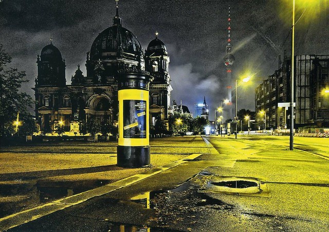
On this postcard you can see the Berlin Cathedral (Berliner Dom in German), an Evangelical church in Berlin. It is the parish church of the Evangelical congregation Gemeinde der Oberpfarr- und Domkirche zu Berlin, a member of the umbrella organisation Evangelical Church of Berlin-Brandenburg-Silesian Upper Lusatia. Its present building is located on Museum Island in the Mitte borough. The Berlin Cathedral has never been a cathedral in the actual sense of that term since it has never been the seat of a bishop.

Metro Bridge and Smolenskaya Embankment, Moscow, Russia

Another transport-related postcard.. and another surprise :) I won this card in MZebra's lottery on the Postcrossing forum earlier this year. I had had this card in my favourites for a while so I was really happy to receive one at last!


This postcard shows the Metro bridge and Smolenskaya Embankment in Moscow, Russia. I was trying to dig some info in Wikipedia but didn't have much success. I have no idea if this is the same bridge as th eSmolensky Metro Bridge...?

Lisboa, Portugal

Another meet-up card, this time from the Postcrossing International Meeting in Lisboa on 9th & 10th June 2012. This one was a proper surprise - it was sent by my dear Dutch friend Astrid, I had no idea she was going to this meet-up! :O...! I'm a wee bit jealous.. :P She's been to so many of these meetings. This particular one sounds like a lot of fun (..although I bet all PC meetings are :P), and I recognise most of the people who signed the card, yay! :D


On this card you can see Elevador da Bica, a funicular in Lisbon, Portugal, that forms the connection between the Calçada do Combro/Rua do Loreto and the Rua de S. Paulo. It is operated by Carris.

The Bica funicular was opened on 28 June, 1892. It climbs the Rua da Bica de Duarte Belo for 245 metres from the Rua S. Paulo. The lower station of this funicular railroad is almost hidden behind a facade on the Rua de S. Paulo with the inscription "Ascensor da Bica". It was constructed by Raoul Mesnier de Ponsard and opened to the public in 1892. In 2002 it was designated a National Monument.

Jiufen, Taipei, Taiwan

Last month there was a post in the Postcrossing blog about a special Postcrossing cancellation. I loved the idea but was too late to ask if I could receive a postcard with that cancellation, and I don't have any very close Postcrossing friends in Taiwan so I didn't think I had any changes of receiving this cancellation. ...which is why I was so surprised to find a postcard with the cancellation on in my mailbox earlier this month. I had an official with the cancellation (although the card is only signed by the sender.. maybe Taiwanese meet-ups are different to those elsewhere in that not everyone signs all cards?? Does anyone know?)! What a lovely surprise! :)


On the card you can see a view of Jiufen, a mountain area in Taipei. I've already written about the place here so I won't repeat myself again here. It's such a lovely view, though, and I love the colours and the misty atmosphere. So dreamy!


...and here's the special cancellation alongside with some really pretty stamps. :)

Canterbury Plains, New Zealand

The vast majority of my postcards are received through Postcrossing. There are some exceptions, though, and recently I've been trying to be more active in Heather's postcard group on facebook. It's such a lovely group, and everyone is so nice and friendly. :) This beautiful view from New Zealand is one of the cards I've received through that group. Thank you so much, Aaron!


The Canterbury Plains are an area in New Zealand centred to the south of the city of Christchurch in the Canterbury Region. Their northern extremes are at the foot of the Hundalee Hills in the Hurunui District, and in the south they merge into the plains of North Otago beyond the Waitaki River.

The Canterbury Plains were formed from quaternary moraine gravels deposited during glacial periods in the late pleistocene approximately 3 million years to 10,000 years ago. The alluvial gravels were then reworked as shingle fans of several of the larger rivers, notably the Waimakariri, the Rakaia, the Selwyn, and the Rangitata. Part of the Canterbury-Otago tussock grasslands the land is suitable for moderately intensive livestock farming, but is prone to droughts, especially when the prevailing wind is from the northwest. At these times, the weather phenomenon known as the Nor'west arch can be seen across much of the plain.

A major earthquake on 4 September 2010 revealed a previously unknown geological fault beneath the Canterbury Plains and created a surface rift that offset features by as much as four meters in places.

Wednesday 20 June 2012

Anuradhapura, Sri Lanka

I thought I'd finish with an old card today. I received this one way back in 1998 from my Sri Lankan penpal Dinushka. I've written about her in this blog before and like I said then, I miss her, it would be nice to still stay in touch but I guess she's too busy with her life. Anyway, when we still wrote letters to each other we often included postcards with our letters, and I received some real treats from her. This is one of those cards.


Anuradhapura is one of the ancient capitals of Sri Lanka, famous for its well-preserved ruins of ancient Sri Lankan civilization.It was 3rd capital of the Kingdom of Rajarata after Tambapanni and Upatissa Nuwara.

The city, now a UNESCO World Heritage Site, lies 205 km north of the current capital Colombo in Sri Lanka's North Central Province, on the banks of the historic Malvathu Oya. It is one of the oldest continuously inhabited cities in the world and one of the eight World Heritage Sites of Sri Lanka.

From the 4th century BC, it was the capital of Sri Lanka until the beginning of the 11th century AD. During this period it remained one of the most stable and durable centers of political power and urban life in South Asia. The ancient city, considered sacred to the Buddhist world, is today surrounded by monasteries covering an area of over sixteen square miles (40 km²).

Anuradhapura has the oldest identified tree in the world: the sacred bo-tree (ficus religiosa). There are also a number of monuments of the great Sinhala civilization in Anuradhapura.

Bangkok, Thailand

This postcard is very special to me. It was sent to me and Matt by our friend Panithan, who used to study in Wolverhampton when I was an exchange student there as well, and she was a member of the same university Aikido club as me and Matt. She's since had to move back home to Thailand. I miss her so much :( If I had more money I'd love to go visit her. Maybe one day...


Bangkok is the capital city of and largest urban area in Thailand. It is known in Thai as Krung Thep Maha Nakhon or simply Krung Thep, meaning "city of angels". Bangkok is by far the most densely populated city in Thailand with about 12 million people. Bangkok was a small trading post near the mouth of the Chao Phraya River during the Ayutthaya Kingdom in the 15th century. It eventually grew in size and became the site of two capital cities: Thonburi in 1768 and Rattanakosin in 1782.

Because of its strategic location in Southeast Asia, Siam (later Thailand) acted as a buffer-zone between the French and British colonial empires. Bangkok itself has gained a reputation as an independent, dynamic and influential city. Bangkok is the political, social and economic centre of Thailand, and one of the leading cities in Southeast Asia.

Due to the 1980s and 1990s Asian investment boom, many multinational corporations make their regional headquarters in Bangkok and the city is a regional force in finance and business. Its increasing influence on global politics, culture, fashion and entertainment underlines its status as an Alpha global city. In 2009, it was the second most expensive city in South-East Asia behind Singapore. The city's many cultural landmarks and attractions in addition to its nightlife venues has made it synonymous with exoticism. Its rapid modernization, reflected in the cityscape and the urban society, has left untouched the historic Grand Palace, Wat Arun, Vimanmek Palace Complex and hundreds of Buddhist temples draw about 10 million international visitors  each year, second only to London.


Valparaiso, Chile

This beautiful view from Chile is from a swap with dear Daniela last year. Valparaiso is a Unesco site, and to me it looks totally fascinating, so beautiful and colourful!


Valparaíso is a city and commune of Chile, center of its third largest conurbation (Greater Valparaíso) and one of the country's most important seaports; it is an increasingly important cultural center in the Southwest Pacific hemisphere. The city is the capital of the Valparaíso Province and the Valparaíso Region. Although Santiago is Chile's official capital, the National Congress of Chile was established in Valparaíso in 1990.

Valparaíso played an important geopolitical role in the second half of the 19th century, when the city served as a major stopover for ships traveling between the Atlantic and Pacific oceans by crossing the Straits of Magellan. Always a magnet for European immigrants, Valparaíso mushroomed during its golden age, when the city was known by international sailors as “Little San Francisco” and “The Jewel of the Pacific.”

Examples of Valparaíso’s former glory include Latin America’s oldest stock exchange, the continent’s first volunteer fire department, Chile’s first public library, and the oldest Spanish language newspaper in continuous publication in the world. The opening of the Panama Canal and reduction in ship traffic dealt a staggering blow to Valparaíso, though the city has staged an impressive renaissance in recent years.

Though nearby San Antonio has become the country’s most commercially important seaport in terms of tonnage moved, the City of Valparaíso remains a vibrant center of Chilean culture. The Greater Valparaíso metropolitan area (which includes Valparaíso, Viña del Mar, Quilpué and Villa Alemana) has the third-largest concentration of population in the country after Greater Santiago and Greater Concepción.

Hiiumaa, Estonia

Speaking of holidays... My parents are going to Prague next week for a few days. I'm so jealous, Prague is one of those cities I'd really love to visit as well. It's quite funny though, my parents are going because my sister had told them they need to go on a holiday somewhere else than to their caravan where they always spend their holidays :D I do agree with my sister, though, I think my parents need this. ...although it's not like they spend ALL their holidays at their caravan - they've been to Estonia a few times as well. One of those visits was in 2005 when they visited Hiiumaa. ..and sent me this postcard from there :) I like it how my family have always been into sending postcards from holidays, even way before I had heard of Postcrossing.


The lighthouse is the Kõpu Lighthouse, I think. I've already written about it here so I won't repeat myself again here. The other pictures I'm not sure of, it doesn't say anything on the card (which seems quite unusual for an Estonian postcard; most of the ones I have seem to have some kind of description of the pictures at the back of the card).

Hiiumaa is the second largest island (989 km²) belonging to Estonia. It is located in the Baltic Sea, north of the island of Saaremaa, a part of the West Estonian archipelago. Its largest town is Kärdla.

Archaeological evidence of the first human settlement in Hiiumaa dates to as early as the 4th century BC. The first documented record of the island of Dageida was made by contemporary chroniclers in 1228, at the time when Hiiumaa, along with the rest of Estonia, had been conquered by Germanic crusaders. In 1254, Hiiumaa was divided between the Bishopric of Ösel-Wiek and the Livonian branch of the Teutonic Order, who were also partly acting on behalf of the Hanseatic League.

 The island was part of Swedish Estonia from 1563 to 1721, after which it passed to the Russian Empire as part of the Governorate of Estonia, although Dagö's Swedish population kept most of their privileges. Most of the island's previously numerous Swedish-speaking population emigrated or were "Estonianised" during the period of Imperial Russian rule, although a small minority remains to this day. Estonian Swedes are also known as "aibofolke" (meaning island people in Swedish) or "rannarootslased" (meaning coastal Swedes in Estonian).

Hiiumaa was occupied during World War I by the Imperial German Army, in Operation Albion. After the war, it became a part of independent Estonia. It was annexed by the Soviet Union in 1940, by Nazi Germany in 1941, and by the Soviets again in 1944. It was then a part of the Estonian Soviet Socialist Republic until the Soviet Union's collapse in 1991. During the Soviet era Hiiumaa was declared a restricted zone, closed to foreigners and to most mainland Estonians. Since 1991, the island has been a part of independent Estonia.


Greece

I was talking to mum over Skype the other day and she told me my grandma is going on holiday abroad again, this time to Rhodes, Greece. That brought back memories as grandma once took me to Rhodes when I was about seven years old. It could be nice to visit again and see if it's anything like I remember the place to be. Probably not... :P I wouldn't mind visiting somewhere else in Greece, either, although perhaps not Athens or other bigger cities/towns as I would be a bit nervous of possible unrest and demonstrations.

Anyway. This lovely map is one of my first official Postcrossing postcards from Greece so it's kinda special to me. ...and I sort of like multiviews when there are THIS many pictures, and they seem to fit together quite well as there's so much blue.


GR-7427
 
Greece, officially the Hellenic Republic, is a country in Southern Europe, politically considered part of Western Europe. Athens is the capital and the largest city in the country (its urban area also including Piraeus). The population of the country is about 11 million.


Greece has land borders with Albania, the Republic of Macedonia and Bulgaria to the north, and Turkey to the east. The Aegean Sea lies to the east of mainland Greece, the Ionian Sea to the west, and the Mediterranean Sea to the south. Greece has the 11th longest coastline in the world at 13,676 km in length, featuring a vast number of islands (approximately 1,400, of which 227 are inhabited), including Crete, the Dodecanese, the Cyclades, and the Ionian Islands among others. Eighty percent of Greece consists of mountains, of which Mount Olympus is the highest at 2,917 m.

Modern Greece traces its roots to the civilization of ancient Greece, generally considered the cradle of Western civilization. As such it is the birthplace of democracy, Western philosophy, the Olympic Games, Western literature and historiography, political science, major scientific and mathematical principles, and Western drama, including both tragedy and comedy. This legacy is partly reflected in the seventeen UNESCO World Heritage Sites located in Greece, ranking Greece 7th in Europe and 13th in the world. The modern Greek state was established in 1830, following the Greek War of Independence.


I totally adore these stamps, particularly the one on the right. Fresh tomatoes and feta, mmmmmm!!!

The Bear Mountain, Crimea, Ukraine

We are having a mini summer here in England today :) It was warm enough to go out in a t-shirt, and I was sweating even then! A perfect excuse for some ice crea, then, I say! :D I do wish I could go on a beach on a day like this but it's not like there are any in the middle of England :P Oh well, at least I can see beaches and the sea on postcards, like this one I once received in a swap with dear Katya.


On this postcard you can see the Bear Mountain in Partenit, a seaside townlet in the southern part of Crimea, Ukraine. The name has its origins in the Greek “Parthenon.” Lying just east of the Bear Mountain, Partenit is on a fairly flat coastal plot of land, although the elevation quickly rises the further away one goes from the sea. Much of the architecture of the city is in the Soviet realist style. The current permanent-resident population is largely Russian Ukrainian, with a significant influx of Tatars and Armenians. Crimea, or the Autonomous Republic of Crimea, is a sub-national unit, an autonomous republic, of Ukraine. It is located on the northern coast of the Black Sea, occupying a peninsula of the same name. It was often referred to with the definite article, as the Crimea, until well into the 20th century.

Crimea is now an autonomous parliamentary republic which is governed by the Constitution of Crimea in accordance with the laws of Ukraine. The capital and administrative seat of the republic's government is the city of Simferopol, located in the center of the peninsula. Crimea's area is 26,200 square kilometres and its population was 1,973,185 as of 2007.

Crimean Tatars, an ethnic minority who now make up about 13% of the population, formed in Crimea in the late Middle Ages, after the Crimean Khanate had come into existence. The Crimean Tatars were forcibly expelled to Central Asia by Joseph Stalin's government. After the fall of the Soviet Union, some Crimean Tatars began to return to the region. However, a majority of the population consists of Russians, and the Russian language has official status in the autonomous republic.

Thursday 14 June 2012

French Guiana

One more card for today, and what a treat it is! This is my first written and stamped postcard from French Guiana, one of those places I never thought I'd receive a postcard from one day. ..well, I didn't even know of the country before I joined Postcrossing :P It looks like a proper tropical paradise, must be a wonderful place to visit.


French Guiana is an overseas region of France, consisting of a single overseas department located on the northern Atlantic coast of South America. It has borders with two nations: Brazil to the east and south, and Suriname to the west. Its 83,534 km2 have a very low population density of less than 3 /km2, with almost half of its 229,000 people in 2009 living in the urban area of Cayenne, its capital.

The addition of the adjective "French" in English comes from colonial times when five such colonies existed (The Guianas), namely from west to east: Spanish Guiana (now Guayana Region in Venezuela), British Guiana (now Guyana), Dutch Guiana (now Suriname), French Guiana, and Portuguese Guiana (now Amapá, a state in far northern Brazil). French Guiana and the two larger countries to the north and west, Guyana and Suriname, are still often collectively referred to as the Guianas and comprise one large shield landmass.


French Guiana is one of those places that don't issue their own stamps, so French stamps are used instead. I do wonder why the cancellation doesn't mention anything about the mailing place, but then French cancellations are quite confusing to me sometimes anyway. :p

Daishō-in, Mount Misen, Miyajima, Japan

When I started Postcrossing I used to receive quite a lot of postcards from Japan. I don't get them that often anymore and it's always a real treat to receive one, such as this beautiful shrine from Miyajima.


On this postcard you can see Daishō-in, the main shrine of Mount Misen. Mount Misen is a holy mountain on the holy island Itsukushima in Hatsukaichi, Hiroshima. It is situated within the World Heritage area of Itsukushima Shrine.

The sea around the island (Seto Inland Sea) and all of the island are within Setonaikai National Park. The foothills of the north side of the mountain are covered by primeval forest and have many buildings and gates, including the temple of  Daishō-in.


Such a beautiful lighthouse stamp, and a lovely special cancellation! There's actually another special cancellation (in the shape of a maple leaf) on the card as well but it's on top of the writing so I didn't want to scan it.

Batan Island, the Philippines

A lovely lighthouse view I received from dear Maerose last year. I really like that car, too, it's so colourful!


Batan island is the main island of the Batanes Province in the northern Philippines, part of the Batanes Islands group and the Luzon Volcanic Arc. It is home to the provincial capital Basco. The island is known chiefly for Mount Iraya. This lighthouse is located in Naidi Hills. Aside from serving as a lighthouse to navigators, fishermen, seafarers and other travellers, this structure which is equivalent in height to a 6 storey building is also a tourist attraction. Its viewing deck at the 5th level is the perfect location for viewing the whole Batanes Island.

Hoi An market, Vietnam

Another market view, this time from Vietnam, sent by dear Jo. I absolutely adore this postcard, it's so colourful and full of details, and the vegetables look so yummy!


I have no idea what some of these vegetables are, but I'd guess it includes at least carrots, sweet potatoe, yam, onions, garlic, some sort of melon, pumpkin.. and possibly daikon and turnip? Help, anyone? I'd love to try the small onions on the top, and I'd guess that garlic (and all the veggies as well) is a lot fresher than what I normally get in supermarkets here. Super fresh ginger is also something I'd love here, mmmmm...!

Farmers' Market, Austria

A lovely market view I received from the 'Choose a Country' RR earlier this year. It features photos taken by the sender, marcie08, which I think is pretty awesome, I love postcards of markets around the world!


These pictures are from a local farmers' market in Austria, open daily and selling vegetables, fruits, flowers, cheese, meat and fish.. I wish there was something like that where I live, too. My local markets aren't that good, and they're certainly not open every day. I'll have to check when the one in Wolverhampton is open; I want to go there to see if they still sell herbs you could grow on your windowsill. I've done that before and really liked it, even if I'm not very good with plants and usually manage to kill them pretty quickly :(


Wednesday 13 June 2012

North Dakota, USA

I was SO excited to receive this map card, let me tell you. I've been trying to collect a map card of all US states for a couple of years now at least and for a long time my collection was *almost* complete, only missing North Dakota as no one seemed to have any maps of this state, and a couple of swaps I tried to organise before fell through. Earlier this year luck was finally on my side and I got this beautiful map from 'cuzcopete'. Thank you soooo much, Mik!!


North Dakota is a state located in the Midwestern region of the United States, along the Canadian border. The state is bordered by Manitoba and Saskatchewan to the north, Minnesota to the east, South Dakota to the south and Montana to the west. North Dakota is the 19th most extensive, but the 3rd least populous and the 4th least densely populated of the 50 United States. North Dakota was created from the northern portion of the Dakota Territory and admitted to the Union on November 2, 1889, simultaneously with South Dakota.

The state capital is Bismarck and the largest city is Fargo. The primary public universities are located in Grand Forks and Fargo. The U.S. Air Force operates air bases at Minot AFB and Grand Forks AFB.

For more than a decade, the state has had a strong economy, with unemployment lower than the national average, job and population growth, and low housing vacancies. Much of the growth has been based on development of the Bakken oil shale fields in the western part of the state, but it has also had growth in the technology and service sectors. Flooding in June 2011 has caused extensive damage to Minot and threatened Bismarck, the capital city.

State Capital: Bismarck
State Bird: Western Meadowlark
State Flower: Prairie Rose
State Tree: American Elm
Admitted to Union: 1889

Chinatown, Toronto, Canada

A great postcard of the Chinatown in Toronto from my dear Canadian penpal Lauren. I really like seeing pictures of Chinatowns around the world so this was a lovely surprise. (Btw, there's a small Chinatown in Birmingham, too, but I've never seen any postcards of it anywhere. :()


Chinatown is an ethnic enclave in Downtown Toronto, Ontario, Canada, with a high concentration of ethnic Chinese residents and businesses extending along Dundas Street West and Spadina Avenue. First developed in the late 19th century, it is now one of the largest Chinatowns in North America and one of several major Chinese-Canadian communities in the Greater Toronto Area.

Toronto's Chinatown first appeared during the 1870s with the migration of American Chinese from California due to racial conflict and from the Eastern United States due to the depression at the time. The earliest record of Toronto's Chinese community is traced to Sam Ching, who owned a hand laundry business on Adelaide Street in 1878. Ching was the first Chinese person listed in the city's directory. Toronto's downtown Chinatown has two phases in its history since inception:  

First Chinatown (1870s-1961): The original Chinatown was centered near present-day Elizabeth and Hagerman street (43.6539938°N 79.3846643°W). In the 1950s, properties in the First Chinatown were bought-out or expropriated in a controversial manner by the city for the construction of Nathan Phillips Square.  

Old Chinatown (1950s-Present): The present downtown Chinatown is centered at Spadina Avenue and Dundas street (43.6529458°N 79.3980432°W). Although a small Chinese community was already present in this location prior to the 1950s, the "old" Chinatown was formed mainly when businesses with the financial ability moved from the First Chinatown to the Spadina location.

A small house in the forest

Just a small update for today. It's actually Matt's birthday today but he's still at work. I made him a cake (a Star Trek themed laptop cake :D) and sorted out his presents, now I'm just waiting.. and really felt like updating this blog, hehe.

This is another lovely surprise from the Finnish May RR. I'd had this card in my favourites for ages and was really excited to finally receive a copy. ..and it came with an absolutely beautiful stamp and great special cancellations, too! :)


There's not much info about the place on the card, it just says it's a 'small house in the forest'. :p It looks SO pretty, though, I wouldn't mind spending a few days in a place like that. (..but I don't think I'd like to live there.) Speaking of Finland... I'm going there in less than 4 weeks! 9th to 16th July, to be exact. I just booked the plane tickets for me and Matt on Monday. It's going to be interesting as we'll be leaving the day after Aikido Summer School in Birmingham (where I'll be taking my black belt exam... eeek!). The flight's in the morning from Stansted so we'll probably have to take a coach from Birmingham to Stansted right after the summer school finishes. That could be interesting... I'm looking forward to seeing my family again, though. My parents will both be on holiday that week (which is why they wanted us to go then) so I should get to spend quite a bit of time with them. I really need it, after what happened not so long ago..


One of the two stamps issued in Finland this year in the Europa stamps series. (I'm trying to get these stamps from as many countries as possible again, so if you can help, please let me know. So far I only have Finland, Germany, Ireland, Russia, Norway, Poland and Luxembourg (and waiting for Croatia)). ..and the first day cancellation!