Thursday 12 April 2012

Mayotte

I thought I'd finish off today with a card from a country new to my collection: Mayotte. Ok, this wasn't mailed directly from Mayotte but then it doesn't seem like it's too easy to get postcards from there, so I'm really happy to have this one in my collection at least. ...and what's pictured on this card seems pretty fascinating, I love postcards like this!


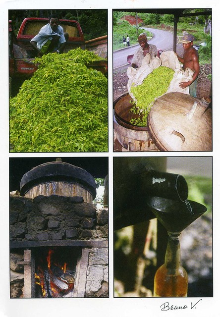
The plant pictured here is Cananga odorata, commonly called Ylang-ylang. It's is a tree valued for its perfume. The essential oil derived from the flowers is used in aromatherapy.

Mayotte, then, is an overseas department and region of France consisting of a main island, Grande-Terre (or Mahoré), a smaller island, Petite-Terre (or Pamanzi), and several islets around these two. The archipelago is located in the northern Mozambique Channel in the Indian Ocean, between northwestern Madagascar and northeastern Mozambique. Mayotte's area is 374 square kilometres, and with its estimated 194,000 people is very densely populated (520 /km2). Its biggest city and prefecture is Mamoudzou. The territory is geographically part of the Comoro Islands, but has been politically separate since a 1974 referendum in which it elected to remain under French rule. The territory is also known as Mahoré, the native name of its main island, especially by advocates of its inclusion in the Union of Comoros. In a 2009 referendum, the population overwhelmingly approved accession to status of department (95.2% voted in favour of departmental status). On March 31, 2011, Mayotte became an overseas department.

Changdeokgung, South Korea

This treat from South Korea arrived last month. I really like it - it's such a lovely view and the palace looks so beautiful, and the blossoms at the front really add to it I think. That, and this is still one of the only postcards I've received from South Korea.


Changdeokgung, also known as Changdeokgung Palace, is set within a large park in Jongno-gu, Seoul, South Korea. It is one of the "Five Grand Palaces" built by the kings of the Joseon Dynasty. Because of its location east of Gyeongbok Palace, Changdeokgung, with Changgyeonggung, is also referred to as the "East Palace". The literal meaning of Changdeokgung is "Palace of Prospering Virtue".

Changdeokgung was the most favored palace of many princes of the Joseon Dynasty and retained many elements dating from the Three Kingdoms of Korea period that were not incorporated in the more contemporary Gyeongbokgung. One such element is the fact that the buildings of Changdeokgung blend with the topography of the site instead of imposing upon nature.

Changdeokgung, like the other Five Grand Palaces in Seoul, was heavily damaged during the Japanese occupation of Korea. Currently, only 30% of the Palace structures remain.

Changdeokgung was added to the UNESCO World Heritage List in 1997. The UNESCO committee inscribing the site stated the place was an "outstanding example of Far Eastern palace architecture and garden design" being exceptional because the buildings are "integrated into and harmonized with the natural setting" and adapted "to the topography and retaining indigenous tree cover."

Plaza de Mayo, Buenos Aires, Argentina

Moving on the somewhere warmer.. I'm not sure why but palm trees really fascinate me. ...maybe because they don't grow where I live, at least not proper palm trees? :P This view of Buenos Aires sort of reminds me of Barcelona for some reason as well O_o


Buenos Aires is the capital and largest city of Argentina, and the second-largest metropolitan area in South America, after Greater Sao Paulo. It is located on the western shore of the estuary of the Río de la Plata, on the southeastern coast of the South American continent. Greater Buenos Aires conurbation, which also includes several Buenos Aires Province districts, constitutes the third-largest conurbation in Latin America, with a population of around thirteen million.

The city of Buenos Aires is not a part of Buenos Aires Province, nor is it the Province's capital, but an autonomous district. In 1880, after decades of political infighting, Buenos Aires was federalised and removed from Buenos Aires Province. The city limits were enlarged to include the towns of Belgrano and Flores (both are currently neighborhoods of the city). The 1994 constitutional amendment granted the city autonomy, hence its formal name: Ciudad Autónoma de Buenos Aires (Autonomous City of Buenos Aires). Its citizens first elected a Chief of Government (i.e. Mayor) in 1996; before, the Mayor was directly appointed by the President of the Republic

People from Buenos Aires are referred to as porteños (people of the port). Buenos Aires is a top tourist destination, and is known for its European style architecture and rich cultural life.

The Plaza de Mayo is the main square in the Monserrat barrio of central Buenos Aires, Argentina. It is flanked by Hipólito Yrigoyen, Balcarce, Rivadavia and Bolívar streets. Since being the scene of the 25 May 1810 revolution that led to independence, the plaza has been a hub of political life in Argentina.

Whiteface Mountain, USA

Just a few cards for now as I felt like updating. I'll have to go out in a bit, I really don't want to though as it's so grey and wet outside. I'd much rather stay at home and be all warm and cosy :( It's not like the postcard below makes me feel warm, either, but I really adore it, it's such a beautiful view and the purple tones are gorgeous!


US-1477851


Whiteface Mountain is the fifth-highest mountain in New York State, and one of the High Peaks of the Adirondack Mountains. Set apart from most of the other High Peaks, the summit offers a 360-degree view featuring the Adirondacks and perhaps on a clear day glimpses of Vermont and even Canada. The skyscrapers of Montreal, 130 km away, can be seen on a very clear day. Located in the town of Wilmington (about 21 kilometers from Lake Placid) the mountain is home to a ski area with the highest vertical drop in the eastern United States (1,050 m). Part of the post World War II growth in recreational skiing attributed to the efforts of returning veterans of the Army's 10th Mountain Division, Whiteface also hosted the alpine skiing competition of the 1980 Winter Olympics.

Lake Placid, then, is a village in the Adirondack Mountains. As of the 2000 census, the village had a population of 2,638. Lake Placid is best known as the two-time site of the Winter Olympics, in 1932 and 1980. In the United States, the village is especially remembered as the site of the 1980 USA–USSR hockey game, the so-called Miracle on Ice, when a group of American college students and amateurs upset the heavily favored Soviet national ice hockey team 4–3 and two days later won the gold medal. Another highpoint during the Games was speed-skater Eric Heiden's performance, winning five gold medals.

During the 1932 games, the trails outside of the city served for the cross-country skiing events and the cross-country skiing part of the Nordic combined event. Lake Placid, St. Moritz, Switzerland, and Innsbruck, Austria are the only sites to have twice hosted the Winter Olympic Games.

Wednesday 11 April 2012

Xunantunich, Belize

One more card for now.. This is the last of the postcards my penpal Lauren sent me from her cruise holiday in the Caribbean earlier this year. She really got to visit some amazing places!


On this postcard you can see Xunantunich, a Maya archaeological site in western Belize, about 130 km west of Belize City, in the Cayo District. Xunantunich is located atop a ridge above the Mopan River, within sight of the Guatemala border. Its name means "Stone Woman" in the Maya language (Mopan and Yucatec combination name), and, like many names given to Maya archaeological sites, is a modern name; the ancient name is currently unknown. The "Stone Woman" refers to the ghost of a woman claimed by several people to inhabit the site, beginning in 1892. She is dressed completely in white, and has fire-red glowing eyes. She generally appears in front of "El Castillo", ascends the stone stairs, and disappears into a stone wall.

Most of the structures date from the Maya Classic Era, about 200 to 900 AD. There is evidence that some structures were damaged by an earthquake while they were occupied; this earthquake may have been a reason for the site's abandonment.

The core of Xunantunich occupies about 2.6 km², consisting of a series of six plazas surrounded by more than 26 temples and palaces. One of its structures, the pyramid known as "El Castillo", the second tallest structure in Belize (after the temple at Caracol), at some 40 m tall. Archeological excavations have revealed a number of fine stucco facades on some of the ancient temples of this site. Evidence of construction suggests the temple was built in three stages in the 7th, 8th, and 9th centuries. The fine stucco or "frieze" are located on the final stage.

The first modern explorations of the site were conducted by Thomas Gann in 1894 and 1895. Several projects of archeological excavations have been conducted at the site from the 1930s through the 1990s.

Hyderabad, India

Something a little older for a change... This is the first official I've received from India, back in 2008. ..and after that I've only received two more from there.... I've received a few more postcards from India recently through swaps, though, and am planning on posting about those cards here at some point.


IN-5013


Hyderabad is the capital of Andhra Pradesh, India. It is known by the sobriquet City of Pearls. The city is one of the largest metros in India with an area of 650 square kilometres with a population of 6,809,970 in the city and 7,749,334 in the metropolitan area, making it the fourth most populous city and the sixth-most populous urban agglomeration in the country.

Hyderabad was established in 1591 AD on the banks of the Musi River on the northern tip of the Deccan Plateau by Sultan Muhammad Quli Qutb Shah.The twin cities of Hyderabad and Secunderabad come under the ambit of a single municipal unit, the Greater Hyderabad Municipal Corporation.

Hyderabad was once a global center of the diamond and pearls trade. The city has emerged as a major global center for the information technology (IT) industry, Pharmaceuticals industry and biotechnology industry, due to which it is known as the Genome Valley of India. The Telugu film industry, known as Tollywood, is located in the city.

As of March 2012, Hyderabad is the "Best Heritage City of India", and home to many historical sites, including the UNESCO Asia Pacific Heritage site of Chowmahalla Palace. The city is a regular tourist hotspot and carries many places of interest. Situated on the crossroads of North and South India, Hyderabad has been noted for its unique culture, art and architecture.

On this card you can see Charminar, built in 1591 AD. It has become the global icon of Hyderabad and is listed among the most recognized structures of India. The Charminar is on the east bank of Musi river. To the northeast lies the Laad Bazaar and in the west end lies the granite-made richly ornamented Makkah Masjid.

Guangzhou, China

Moving on to China, not that far from Macau actually - Guangzhou is located pretty much just nort of Macau. This official arrived earlier this year and it immediately caught my eye - I just love the atmosphere in it, and the full moon is gorgeous!


CN-538471


Guangzhou is the capital and largest city of the Guangdong province in the People's Republic of China. Located in southern China on the Pearl River, about 120 km north-northwest of Hong Kong, Guangzhou is a key national transportation hub and trading port. One of the five National Central Cities, it holds sub-provincial administrative status.

Guangzhou is the third largest city in China and southern China's largest city. As of the 2010 census, the city had a population of 12.78 million. Some estimates place the population of the entire Pearl River Delta Mega City built up area as high as 40 million including Shenzhen (10.36 million), Dongguan (8.22 million) and most parts of Foshan (7.19 million), Jiangmen (4.45 million), Zhongshan (3.12 million) and a small part of Huizhou adjoining Dongguan and Shenzhen, with an area of about 20,000 square kilometres (about the size of US state of New Jersey).

Lilau Square, Macau

I don't have too many postcards from Macau so I was really happy to receive this one in a swap last year. ...and it's a Unesco card as well!


Macao, a lucrative port of strategic importance in the development of international trade, was under Portuguese administration from the mid-16th century until 1999, when it came under Chinese sovereignty. With its historic street, residential, religious and public Portuguese and Chinese buildings, the historic centre of Macao provides a unique testimony to the meeting of aesthetic, cultural, architectural and technological influences from East and West. The site also contains a fortress and a lighthouse, the oldest in China. It bears witness to one of the earliest and longest-lasting encounters between China and the West, based on the vibrancy of international trade. [source]

Macau is one of the two special administrative regions of the People's Republic of China. (Hong Kong is the other.) Macau lies on the western side of the Pearl River Delta across from Hong-Kong which is to the east, bordering Guangdong province to the north and facing the South China Sea to the east and south.

The territory's economy is heavily dependent on gambling and tourism, but also includes manufacturing.

Wrocław, Poland

I've said before that I'm not generally too fond of multiviews. A lot of them just seem to be too crowded and you can't see anything properly on them. However, I really like this official I received earlier this year. ...maybe because it's a panoramic card and larger than a normal card so you can still see what's in the pictures? ...and it does help that it has a bicycle on it ;)


PL-366628


Wrocław is situated on the River Oder in Lower Silesia. It is the largest city in southwestern Poland.

Wrocław was the historical capital of Silesia, and today is the capital of the Lower Silesian Voivodeship. Over the centuries, the city has been part of either Poland, Bohemia, Austria, Prussia, or Germany, but since 1945 it has been part of Poland as a result of border changes after World War II. According to official figures for 2010, its population is 632,996, making it the fourth largest city in Poland.

Wroclaw is one of the hosts of UEFA Euro 2012. Wrocław has been selected as a European Capital of Culture for 2016. It will share the title with San Sebastián (aka Donostia), Spain. In 2017, Wrocław will host the World Games, a competition in 37 non-olympic sport disciplines.

Tyumen, Russia

Moving on to Russia, to Western Siberia... I haven't been very active in trying to collect a postcard from all different regions of Russia recently. I should really try to continue with that project again...


Tyumen is the largest city and the administrative center of Tyumen Oblast, Russia, located on the Tura River 2,144 kilometers east of Moscow. It has a population of 581,758 (2010 Census preliminary results).

Tyumen is the oldest Russian settlement in Siberia. Founded in 1586 to support Russia's eastward expansion, the city has remained one of the most important industrial and economic centers east of the Ural Mountains. Located at the junction of several important trade routes and with easy access to navigable waterways, Tyumen rapidly developed from a small military settlement to a large commercial and industrial city. The central part of Old Tyumen retains many historic buildings from throughout the city's history.

Today Tyumen is one of Russia's most important business centers and is prominent in the political and cultural life of Russia.

Tyumen is the transportation hub and industrial center of Tyumen Oblast—a vast oil-rich region stretching from the Kazakh border to the Arctic Ocean—as well as the home of many companies active in Russia's oil and gas industry.

Lyngvig Fyr, Denmark

Easter is gone... I'm having a long week off, though, as the place where I volunteer was closed yesterday and today's my day off anyway :D So time to update this blog again! I've got a pretty random selection for today, starting with a nice lighthouse postcard from Denmark.


Lyngvig Fyr (Lyngvig Lighthouse) was built in 1906 and is situated on Holmsland dune between Søndervig and Hvide Sande in Denmark. The burner flame height is 53 m while the tower itself is 36 meters high. The lighthouse is located in the former Holmsland municipality in Ringkjøbing County on the west coast of the Jutland peninsula in west Denmark.

Sunday 8 April 2012

Lima, Peru

One more card for now... from a swap with Jane last year, showing the historic centre of Lima, which is also a Unesco site. It looks so beautiful in the dark, although I imagine it must be really nice during the day as well :)


Lima is the capital and the largest city of Peru. It is located in the valleys of the Chillón, Rímac and Lurín rivers, in the central part of the country, on a desert coast overlooking the Pacific Ocean. Together with the seaport of Callao, it forms a contiguous urban area known as the Lima Metropolitan Area. With a population approaching 9 million, Lima is the fifth largest city in Latin America, behind Mexico City, São Paulo, Buenos Aires and Rio de Janeiro. Lima is home to one of the largest financial hubs in Latin America.

Lima was founded by Spanish conquistador Francisco Pizarro on January 18, 1535, as la Ciudad de los Reyes, or "the City of Kings". It became the capital and most important city in the Spanish Viceroyalty of Peru. Following the Peruvian War of Independence, it became the capital of the Republic of Peru. Today, around one-third of the Peruvian population lives in the metropolitan area.

Lima is home to one of the oldest higher learning institutions in the New World. The National University of San Marcos, founded on May 12, 1551 during Spanish colonial regime, is the oldest continuously functioning university in the Americas.

The historic centre of Lima bears witness to the architecture and urban development of a Spanish colonial town of great political, economic, and cultural importance in Latin American. San Francisco de Lima is an outstanding example of a convent ensemble of the colonial periods in Latin America and, along with Santa Catalina de Arequipa, is one of the most complete.

Djémila, Algeria

I thought I'd throw in an older postcard for a change.. I received this as an official back in 2009, and it's one of the only (if not the only one?!) written and stamped postcards I've ever received from Algeria. ...and it's a Unesco site as well!


DZ-794


Djémila is a mountain village in Algeria, near the northern coast east of Algiers, where some of the best preserved Berbero-Roman ruins in North Africa are found. It is situated in the region bordering the Constantinois and Petite Kabylie (Basse Kabylie).

In 1982, Djémila became a UNESCO World Heritage Site for its unique adaptation of Roman architecture to a mountain environment. Significant buildings in Djémila include a theatre, two fora, temples, basilicas, arches, streets, and houses. The exceptionally well preserved ruins surround the forum of the Harsh, a large paved square with an entry marked by a majestic arch.

Ålesund, Norway

A gorgeous, HUGE postcard I received from the 'Choose a Country' RR on the Postcrossing forum earlier this year. What a magnificent city Ålesund looks like! ...and speaking of the abovementioned RR, I'm so excited Peggy is organising another surprise group again!


Ålesund is a town and municipality in Møre og Romsdal county, Norway. It is part of the traditional district of Sunnmøre, and the center of the Ålesund Region. It is a sea port, and is noted for its unique concentration of Art Nouveau architecture.

Ålesund town is the administrative centre of the municipality as well as the principal shipping town of the Sunnmøre district. Ålesund municipality has a population of 42,982 as of 2010, while the greater Ålesund area has a population of 47,772 (this also includes most of neighboring Sula as well).

The municipality of Ålesund occupies seven of the outer islands in the county of Møre og Romsdal: Hessa, Aspøya, Nørvøya, Oksnøya, Ellingsøya, Humla, and Tørla. The town centre is located on the islands Aspøya and Nørvøy, while Heissa and Oksnøya contain residential areas.

The second largest island, Elingsøya, used to be accessible only by boat or by road via Skodje municipality, but an undersea tunnel was built in 1987 to make travelling between the island and the town centre more convenient. The tunnel is 3,481 metres long, and was upgraded in 2009.

Situated 236 km north northeast of Bergen, Ålesund is adjacent to the Hjørund and Geiranger fjords, the latter being on UNESCO's list of World Heritage Sites.

Ålesund has the most important fishing harbour in Norway. The town's fishing fleet is one of the most modern in Europe. Ålesund and surroundings also has a large furniture industry. Some well-known household items are manufactured here.

Latvia map

Something a little different.. I received this lovely map reprint as an official earlier this year.


LV-61072


Latvia is a country in the Baltic region of Northern Europe. It is bordered to the north by Estonia, to the south by Lithuania, to the east by the Russian Federation, to the southeast by Belarus, and shares maritime borders to the west with Sweden. With 2,067,887 inhabitants and a territory of 64,589 km2 it is one of the least populous and least densely populated countries of the European Union. The capital of Latvia is Riga. The official language is Latvian and the currency is called Lats (Ls). The country has a temperate seasonal climate.

Latvia is a unitary parliamentary republic and is divided into 118 administrative divisions of which 109 municipalities and 9 cities. There are five planning regions: Courland (Kurzeme), Latgalia (Latgale), Riga (Rīga), Vidzeme and Zemgale. The Republic of Latvia was founded on November 18, 1918. It was occupied and annexed by the Soviet Union between 1940–1941 and 1945–1991 and by Nazi Germany between 1941–1945. The peaceful "Singing Revolution" between 1987 and 1991 and "Baltic Chain" demonstration on August 23, 1989 led to the independence of the Baltic states. Latvia declared the restoration of its de facto independence on August 21, 1991.

Hong Kong

A wonderful treat from Heather when she visited Hong Kong last year.


My friend Miranda is going back home there later this month. How cool it would be to explore the place with her one day... Although I'm really not jealous of her at the moment as she's been sick since coming back from HK in January, and British doctors have been totally useless :S I hope she'll get everything sorted out soon!

As for this card, I'm guessing it shows central Hong Kong.. on the back of the card it just says 'Panoramic view of Hong Kong at Evening'. Ahhh, I'd love to take photos of this kind of views!


This was the main point of this postcard.. a FANTASTIC, huge stamp/miniature sheet. THe postage is actually way more than what is needed but Heather told me she really liked it so wanted to use it. (..and both she and Miranda have told me that the price of mailing a postcard from Hong Kong is really cheap...) There's an awesome special cancellation, too, although I had to giggle a bit when I saw it had been placed upside down :P

Kyoto, Japan

It's supposed to be spring here and well, it does look like it. Some trees have started to blossom, too (although not the one across the road from our house or the one further down the road. I'm really looking forward to those --> photo opportunities!). This week has been really cold, though, and I've had to start using a second blanket in bed again at night, brrr.

It must be really beautiful in Japan at the moment as this is the cherry blossom season over there. I've been admiring photos online, some of them are truly breathtaking! This cherry blossom card from Japan arrived last year - and it has a matching stamp, too!


Hanami is the Japanese traditional custom of enjoying the beauty of flowers, "flower" in this case almost always meaning cherry blossoms ("sakura") or (less often) plum blossoms ("ume"). From the end of March to early May, sakura bloom all over Japan, and around the first of February on the island of Okinawa. The blossom forecast is announced each year by the weather bureau, and is watched carefully by those planning hanami as the blossoms only last a week or two. In modern-day Japan, hanami mostly consists of having an outdoor party beneath the sakura during daytime or at night. In some contexts the Sino-Japanese term kanō is used instead, particularly for festivals. Hanami at night is called yozakura. In many places such as Ueno Park temporary paper lanterns are hung for the purpose of yozakura. On the island of Okinawa, decorative electric lanterns are hung in the trees for evening enjoyment, such as on the trees ascending Mt. Yae, near Motobu Town, or at Nakajin Castle.