Saturday 28 January 2012

Altja fishing village, Lahemaa, Estonia

I've had this card in my favourites for ages, I'm really excited to finally have it! ...and the silly thing is, the postcard wasn't even the main point of this swap - Heidi was offering the Estonian Year of the Dragon stamp and I was interested in getting one. So yeah, this is a pretty awesome postcard, it even has a first day cancellation!


The card shows some sheds for fishing nets at Altja fishing village in Lääne-Viru County, in northeastern Estonia. Altja is also located in Lahemaa National Park (established in 1971). The park area covers 725 km² (including 250.9 km² of sea). It was the first national park of the former Soviet Union. Given its size it is one of Europe's biggest national parks. Its charter calls for the preservation, research and promotion of North-Estonian landscapes, ecosystems, biodiversity and national heritage.

The name Lahemaa originates from the most thoroughly studied and visited part of the North-Estonian coast, where four large peninsulas (Juminda, Pärispea, Käsmu and Vergi) are separated from each other by four bays (Kolga, Hara, Eru and Käsmu.) Lahemaa translates roughly as "Land of Bays".

Taiwan

My friend Miranda visited her home in Hong Kong again recently, and she also went to Taiwan for a few days. She was kind enough to bring me some postcards from her trip ^_^ I'll probably post one of the postcards from Hong Kong here at some point, meanwhile here's one from Taiwan. I love the colours and the sky in this one.


The National Chiang Kai-shek Memorial Hall is a famous monument, landmark and tourist attractions erected in memory of Generalissimo Chiang Kai-shek, former President of the Republic of China. It is located in Taipei, Republic of China (Taiwan).

The monument, surrounded by a park, stands at the east end of Memorial Hall Square. The structure is framed on the north and south by the National Theater and National Concert Hall. The entire plaza is located within sight of the Presidential Office Building.

Kraków, Poland

Just a small update for today. I'm getting behind with everything again :( I received this postcard from dear Ana earlier this month. Thank you so much for the lovely surprise! Ahhh, I wish I could travel a bit more, too. I certainly wouldn't mind visiting Kraków, it looks really pretty ^_^


Kraków is the second largest and one of the oldest cities in Poland. Situated on the Vistula River in the Lesser Poland region, the city dates back to the 7th century. Kraków has traditionally been one of the leading centres of Polish academic, cultural, and artistic life and is one of Poland's most important economic hubs. It was the capital of Poland from 1038 to 1596; the capital of the Grand Duchy of Kraków from 1846 to 1918; and the capital of Kraków Voivodeship from the 14th century to 1999. It is now the capital of the Lesser Poland Voivodeship.

The city has grown from a Stone Age settlement to Poland's second most important city. It began as a hamlet on Wawel Hill and was already being reported as a busy trading centre of Slavonic Europe in 965. With the establishment of new universities and cultural venues at the emergence of the Second Polish Republic and throughout the 20th century, Kraków reaffirmed its role as a major national academic and artistic centre. The city has a population of approximately 760,000 whereas about 8 million people live within a 100 km radius of its main square.

After the invasion of Poland by Nazi Germany at the start of World War II, Kraków was turned into the capital of Germany's General Government. The Jewish population of the city was moved into a walled zone known as the Kraków Ghetto, from which they were sent to extermination camps such as Auschwitz and the concentration camp at Płaszów.

In 1978, Karol Wojtyła, archbishop of Kraków, was elevated to the papacy as Pope John Paul II – the first Slavic pope ever, and the first non-Italian pope in 455 years. Also that year, UNESCO approved the first ever sites for its new World Heritage List, including the entire Old Town in inscribing Cracow's Historic Centre.

Saturday 21 January 2012

Gibraltar

One more card for today, received last year. ..and I could tick more more card off my 'missing countries' list with this one :) That, and it has a lighthouse on it, brilliant!


Gibraltar is a British overseas territory located on the southern end of the Iberian Peninsula at the entrance of the Mediterranean. A peninsula with an area of 6.843 square kilometres, it has a northern border with Andalusia, Spain. The Rock of Gibraltar is the major landmark of the region. At its foot is the densely populated city area, home to almost 30,000 Gibraltarians and other nationalities.

An Anglo-Dutch force captured Gibraltar from Spain in 1704 during the War of the Spanish Succession. The territory was subsequently ceded to Britain "in perpetuity" under the Treaty of Utrecht in 1713. It was an important base for the Royal Navy; today its economy is based largely on tourism, financial services, and shipping.

The sovereignty of Gibraltar is a major point of contention in Anglo-Spanish relations as Spain asserts a claim to the territory. Gibraltarians rejected proposals for Spanish sovereignty in a 1967 referendum and again in 2002. Under Gibraltar constitution of 2006, Gibraltar governs its own affairs, though some powers, such as defence and foreign relations, remain the responsibility of the UK Government.

Rachel, who sent me this card, tells me that the ape is sitting at a viewing point half-way up the rock overlooking Spain. This part of the rock was crucial during the sieges in the defence against Spain.


I find it interesting how Gibraltar has a special UK rate for postage, despite being so far away from the UK. I mean it's easier to understand with the Channel Islands, but I hadn't realised Gibraltar does this as well.

Manila, Phillippines

I received this beautiful card from my postcard pal Maerose in the Philippines last year. Thank you so much, dear!


Manila is the capital of the Philippines. It is one of the sixteen cities forming Metro Manila. Manila is located on the eastern shores of Manila Bay and is bordered by Navotas and Caloocan to the north, Quezon City to the northeast, San Juan and Mandaluyong to the east, Makati on the southeast, and Pasay to the south.

Manila has a total population of more than 1,660,714 according to the 2007 census. Manila is the second most populous city in the Philippines, behind its neighbor, Quezon City. The populace inhabit an area of only 38.55 square kilometers, making Manila the most densely populated city in the world. Metro Manila is the most populous metropolitan area in the Philippines and the 11th in the world with an estimated population of 16,300,000. The greater urban area is the fifth-largest in the world and has an estimated metropolitan population of 20,654,307 people.

The city is divided into six legislative districts and consists of sixteen geographical districts. Within their precincts can be found areas of bustling commerce and some of the most historically and culturally significant iconic landmarks in the country as well as the seat of the executive and judicial branches of the government. It is home to many scientific and educational institutions, as well as numerous sport facilities. These make the city a major political, commercial, cosmopolitan, cultural, educational, religious, and transportation center of the Philippines.

The earliest written account of the city is the 10th-century Laguna Copperplate Inscription which describe an Indianized kingdom maintaining diplomatic relations with the Kingdom of Medang and commercial exchanges with Ancient Japan and Song Dynasty China. The city was invaded by Brunei's Sultan Bolkiah and was already Islamized by the 15th century when the Spanish first arrived. Manila eventually became the center of Spanish activity in the Far East and one end of the Manila–Acapulco galleon trade route linking Latin America and Asia. This caused it to be called the "Pearl of the Orient". Several Chinese insurrections, local revolts, a British Occupation and a Sepoy mutiny also occurred thereafter. Later, it saw the rise of the Philippine Revolution which was followed by the arrival of the Americans who made contributions to the city's urban planning and development only to have most of those improvements lost in the devastation of World War II. Since then the city has been rebuilt.

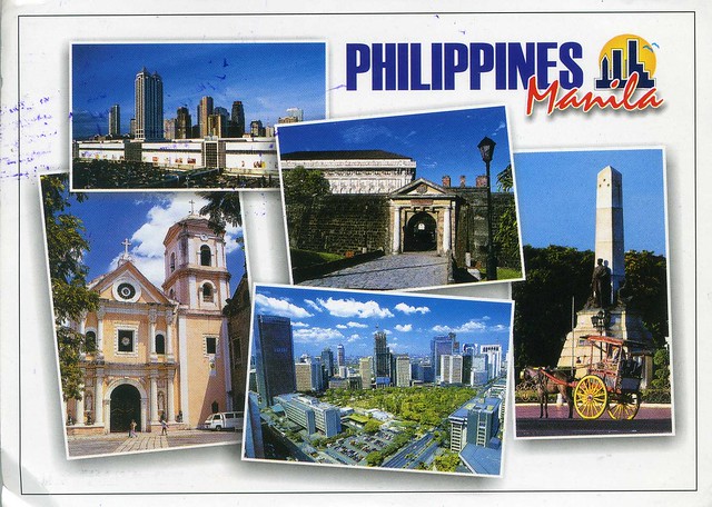
On this postcard you can see a number of places in Manila:

Ortigas Center and Megamall. Entrance to Intramuros, former Spanish residence. Spanish-inspired horse-driving calesa in front of Rizal Monument. Makati, business district of the Philippines. San Augustin Church, one of the oldest churches in the Philippines (and a Unesco site).

Rabat, Morocco

Last year I got a really nice email from Najma in Morocco, asking me if I'd like to swap. I didn't have to think twice ;) I've now received two beautiful postcards from her, this one being the first one. Thank you so much, Najma!


Rabat is the capital and third largest city of the Kingdom of Morocco with a population of approximately 650,000 (2010). It is also the capital of the Rabat-Salé-Zemmour-Zaer region.

The city is located on the Atlantic Ocean at the mouth of the river Bou Regreg. On the facing shore of the river lies Salé, the city's main commuter town. Together with Temara the cities account for a combined metropolitan population of 1.8 million. Silting problems have diminished the Rabat's role as a port; however, Rabat and Salé still maintain important textile, food processing and construction industries. In addition, tourism and the presence of all foreign embassies in Morocco serve to make Rabat one of the most important cities in the country.

The Angel Falls, Canaima National Park, Venezuela

A gorgeous waterfall postcard I received from a Unesco swap last year.


Canaima National Park is a 30,000 km2 park in south-eastern Venezuela that borders Brazil and Guyana. It is located in Bolívar State, and roughly occupies the same area as the Gran Sabana region.

The park was established on 12 June 1962. It is the second largest park in the country, after Parima-Tapirapecó, and sixth biggest national park in the world. It is the size of Belgium or Maryland.

About 65% of the park is occupied by plateaus of rock called tepuis, which are a kind of plateau of millions of years old, with vertical walls and almost flat tops. These constitute a unique biological environment, also of a great geological interest. Its sheer cliffs and waterfalls (including the Angel Falls, which is the highest waterfall in the world, at 1,002 metres) are spectacular landscapes.

The most famous tepuis in the park are Mount Roraima, the tallest and easiest to climb, and Auyantepui, from which fall the Angel Falls. The tepuis are sandstone and date back to a time when South America and Africa were part of a super-continent.

The park is home to indigenous Pemon Indians, part of the Carib linguistic group. The Pemon have an intimate relationship with the tepuis, and believe they are the home of the 'Mawari' spirits. The park is relatively remote, with only a few roads connecting towns. Most transport within the park is done by light plane from the airstrips built by various Capuchin missions, or by foot and canoe. Pemons have developed some basic and luxurious camps, which are mainly visited by tourists from across the world.

In 1994, the Canaima National Park was named a World Heritage Site by UNESCO, as a natural reserve that has abrupt relief special and unique around the world, the tepuis.

woman and flowers

2012 has started pretty well when it comes to postcards; I've already received so many beautiful postcards! This one is from Tina in the US, she sent it as an 'angel' for a RR I joined on the Postcrossing forum last year. How sweet of her!


I had never heard of this 'angeling' thing before but it sounds like such a nice idea. ...and this is such a beautiful postcard! On the back of the card it says the title of the painting is 'Blossoms', and then 'Arthur Drummond 1871-1951. I couldn't find any info about this painter..


Well, the main reason for my posting this card here is the pretty stamps and the cancellation. These 'mailer's postmark permit' cancellations are FANTASTIC, I'm so excited to receive a postcard with one at last! I wish we had cancellations like this in the UK, too. Most cancellations (apart from first day cancellations and some other exceptions) here are horrible, just a mess made by a machine. :(

Saturday 7 January 2012

Santiago de Chile, Chile

Just one more card for today. This one is from Chile, and like most of my Chilean postcards, this one is from Daniela. Thank you so much, dear, this is such a beauty!


Santiago de Chile is the capital and largest city of Chile, and the center of its largest conurbation (Greater Santiago). It is located in the country's central valley, at an elevation of 520 m above mean sea level. Although Santiago de Chile is the capital, legislative bodies meet in the coastal town of Valparaíso, 120 km to the west.

Chile's steady economic growth has transformed Santiago de Chile into one of Latin America's most modern metropolitan areas, with extensive suburban development, dozens of shopping centers, and impressive high-rise architecture. It has a very modern transport infrastructure, including the steadily growing underground Santiago Metro, an effort at modernizing public bus transport and a free flow toll-based ring road and inner city highway system, part of which is tunneled underneath a large section of the city's main river Mapocho connecting the Eastern and Western end of the city in a 25-minute drive. Santiago de Chile is the regional headquarters to many multinationals and a financial center. Santiago de Chile has a diverse, cosmopolitan culture.

Karakorum Highway, Hunza Valley, Pakistan

Vera from Pakistan sent me a message on Flickr last year, asking me if I'd like to swap with her. Of course I did; she had lots of beautiful postcards on offer and it's not like I have many from Pakistan anyway.


The Karakoram Highway (KKH) is the highest paved international road in the world, but at its peak at the China-Pakistan border it is only paved on the Chinese side. It connects China and Pakistan across the Karakoram mountain range, through the Khunjerab Pass, at an altitude of 4,693 m as confirmed by both SRTM and multiple GPS readings. It connects China's Xinjiang region with Pakistan's Gilgit-Baltistan and also serves as a popular tourist attraction. Due to its high elevation and the difficult conditions in which it was constructed, it is also referred to as the "Ninth Wonder of the World.

The Hunza Valley, then, is a mountainous valley in the Gilgit-Baltistan region of Pakistan. The Hunza valley is situated to the north of the Hunza River, at an elevation of around 2,500 metres. The territory of Hunza is about 7,900 square kilometres. Aliabad is the main town with Karimabad as a popular tourist destination because of the spectacular scenery of the surrounding mountains like Ultar Sar, Rakaposhi, Bojahagur Duanasir II, Ghenta Peak, Hunza Peak, Passu Peak, Diran Peak and Bublimating (Ladyfinger Peak), all 6,000 metres or higher.

Vera tells me that the car you can see here is a traditional truck decorated with different handmade accessories. She says that all trucks and public busses in Pakistan look like that.

Quebec, Canada

Heather visited Canada last year and sent me some truly wonderful postcards from there. This is one of them and possibly my favourite - I love cartoon maps like this!


Quebec is a province in east-central Canada. It is the only Canadian province with a predominantly French-speaking population and the only one whose sole official language is French at the provincial level. Quebec is Canada's largest province by area and its second-largest administrative division; only the territory of Nunavut is larger. It is bordered to the west by the province of Ontario, James Bay and Hudson Bay, to the north by Hudson Strait and Ungava Bay, to the east by the Gulf of Saint Lawrence and the provinces of Newfoundland and Labrador and New Brunswick. It is bordered on the south by the US states of Maine, New Hampshire, Vermont, and New York. It also shares maritime borders with Nunavut, Prince Edward Island, and Nova Scotia.

Quebec is Canada's second most populous province, after Ontario. Most inhabitants live in urban areas near the Saint Lawrence River between Montreal and Quebec City, the capital. English-speaking communities and English-language institutions are concentrated in the west of the island of Montreal but are also significantly present in the Outaouais, Eastern Townships, and Gaspé regions. The Nord-du-Québec region, occupying the northern half of the province, is sparsely populated and inhabited primarily by Aboriginal peoples.

Sovereignty plays a large role in the politics of Quebec, and the official opposition social democratic Parti Québécois advocates national sovereignty for the province and secession from Canada. Sovereignist governments have held referendums on independence in 1980 and 1995; both were voted down by voters, the latter defeated by a very narrow margin. In 2006, the Canadian House of Commons passed a symbolic motion, the Québécois nation motion, recognizing the "Québécois as a nation within a united Canada."

While the province's substantial natural resources have long been the mainstay of its economy, sectors of the knowledge economy such as aerospace, information and communication technologies, biotechnology and the pharmaceutical industry also play leading roles. These many industries have all contributed to helping Quebec become the second most economically influential province, second only to Ontario.

Australian Antarctic Territory

An absolutely GORGEOUS, older maxi card I received from a swap last year. This is a real gem, and the huskies are adorable! ^_^


The Australian Antarctic Territory (AAT) is a part of Antarctica. It was claimed by the United Kingdom and placed under the authority of the Commonwealth of Australia in 1933. It is the largest territory of Antarctica claimed by any nation. Since the Antarctic Treaty came into force in 1961, Article 4 of which states "The treaty does not recognize, dispute, nor establish territorial sovereignty claims; no new claims shall be asserted while the treaty is in force", most countries do not recognise territorial claims in Antarctica.

Australia issues postage stamps for the Australian Antarctic Territory. The first issues came in 1957, and sporadically thereafter, settling into a pattern of an annual issue by the 1990s. All have been Antarctic-themed, and all are valid for postage in Australia and its territories, including Antarctica.

Nordkapp, Norway

The Finnish community on the Postcrossing forum has this little project called 'Kesäkorttikaveri' ('summer card pal') every year where you can exchange postcards during the summer with one or several people. Usually people "pair up" themselves and decide how often they send cards to each other. I've participated in it a few times and always really enjoy it, I've met some lovely people that way (and I still exchange cards with one of them!). In summer 2011 one of my card pals was Nina. She visited Norway during that summer and sent me this lovely postcard from there.


Nordkapp (North Cape) is a cape on the island of Magerøya in Northern Norway, in the municipality of Nordkapp. Its 307 metres high, steep cliff is often referred to as the northernmost point of Europe, located at 71°10′21″N 25°47′40″E, 2,102.3 kilometres from the North Pole. However, the neighbouring point Knivskjellodden is actually 1,457 metres farther north. Moreover, both of these points are situated on an island, which means the northernmost point of mainland Europe is in fact Cape Nordkinn (Kinnarodden), about 20 kilometres from the village of Mehamn on Nordkinn Peninsula.

The North Cape is the point where the Norwegian Sea, part of the Atlantic Ocean, meets the Barents Sea, part of the Arctic Ocean.

Brockenbahn, Germany

A lovely official I received early last year. I'm glad the views here aren't snowy like this, but I have to admit snow does look pretty.


DE-813145


Brockenbahn (the Brocken Railway) is one of three tourist metre gauge railways which together with the Harz Railway and Selke Valley Railway form the Harz Narrow Gauge Railways railway network in the Harz mountain range of Germany. It runs from the station of Drei Annen Hohne at 542 m, where it joins the Harz Railway, via Schierke and the Bode River valley to the summit of the Brocken, the highest mountain of the Harz at 1,141 m and part of the Harz National Park.

Wednesday 4 January 2012

Happy New Year 2012!

Happy New Year! Mine started pretty uneventfully - I stayed the New Year's Eve at home on my own, drinking lots of tea, watching 'The Mentalist' on dvd and trying to crochet a sock. Not that I mind spending time like that, I'm not generally much of a party person. I hope this year will be a good one and bring me lots of nice postcards amongst other things :D I haven't made any resolutions as I don't believe in them; I already know what I should do/achieve.


2012 is the Year of the Dragon. I received this gorgeous postcard from my dear Japanese friend Tam yesterday. Thank you so much, dear!

Incidentally, I really like these Chinese New Year's stamps and would love to receive them from other countries as well. If you are reading this and your country actually issues these stamps (the UK doesn't :() and you would like to swap, please let me know!