Saturday 25 June 2011

Lighthouses of Australia

One more card for today, from another dear person. I have received SO many gorgeous postcards from Heather, it's always a joy to find postcards from her in my mailbox!


Info from the back of the postcard:

Australia's coastline is home to over 350 lighthouses which have been erected over the past 200 years, their design is the same and yet delightfully varied. Here is a selection of Australia's lighthouses over 24 meters high, as depicted by Richard Braddish.

I'm not very good at adding pictures on blogspot so you can't really read much of the info in the picture above. Here's a link to a large-size scan if you want to read more about these lighthouses.


The stamp on the right is from a set of 2 Year of the Rabbit stamps issued earlier this year. The other two stamps really confuse me...! I thought they were fairly new but I can't find any information about them anywhere! :O Do you know anything more about them, Heather?

EDIT. Thank you for the info! The stamps are from a set of 4 stamps issued last year, showing Cocos (Keeling) Islands Flowers.

Jajce, Bosnia and Herzegovina

A beautiful waterfall postcard I received from my dear penpal Snježana recently.


Jajce is a city and municipality located in the central part of Bosnia and Herzegovina. It is on the crossroads between Banja Luka, Mrkonjić Grad and Donji Vakuf, on the confluence of the rivers Pliva and Vrbas.

Jajce was first built in the 14th century and served as the capital of the independent Bosnian kingdom during its time. The town has gates as fortifications, as well as a castle with walls which lead to the various gates around the town.

The town is famous for its beautiful waterfall where the Pliva River meets the river Vrbas. It was 30 meters high, but during the Bosnian war, the area was flooded and the waterfall is now 20 meters high. The flooding may have been due to an earthquake and/or attacks on the hydroelectric power plant further up the river.


The stamps on the envelope were gorgeous, I couldn't find any info on any of them, though.

Chukotka, Russia

This postcard is from my dear friend Katya in Russia. We did a "diary" style swap earlier this year where we sent each other a card a day, writing about the day on the card. It was so much fun, I'd love to do a similar swap with someone else at some point. I actually have two friends named Katya in Russia, and they both live in the Moscow region as well. This one is from Katya Z. :)


On this card you can see the Cape of Saint Dionysius in Chukotka, East of Russia. Chukotka is a federal subject of Russia (an autonomous okrug) located in the Russian Far East. Chukotka has a population of 53,824 according to the 2002 Census, and a surface area of 737,700 km2. The principal town and the administrative center is Anadyr. Chukotka is the most northeasterly region of Russia and, since the sale of Alaska to the United States, has been the only part of Russia lying partially in the Western Hemisphere (east of the 180th meridian).

Ecologically, Chukotka can be divided into three distinct areas: the northern arctic desert, the central tundra, and the taiga in the south. About half of its area is above the Arctic Circle. This area is very mountainous, containing the Chukotsky Mountains and the Anadyr Range. Large parts of Chukotka are covered with moss, lichen, and arctic plants, similar to western Alaska. Surrounding the Gulf of Anadyr and in the river valleys grow small larch, pine, birch, poplar, and willow trees. More than 900 species of plants grow in Chukotka, including 400 species of moss and lichen. It is home to 220 bird species and 30 fresh water fish species.

Chukotka's climate is influenced by its location on the three neighboring seas: the Bering Sea, the East Siberian Sea, and the Chukchi Sea. The weather is characterized by cold northerly winds that could quickly change to wet southern winds. Cape Navarin has the highest number of hurricanes and storms in Russia. The coastal areas are windy with little precipitation, between 200 and 400 mm per year. Temperature varies from −15 °C to −35 °C in January and from 5 °C to 14 °C in July.


Katya always uses the most amazing stamps on her cards and this one is no exception. These stamps are from a set of 5 stamps issued in 2003, depicting Fruits.

Estonia

This is a pretty cool card - there's a lighthouse AND bicycles in it! It's a little sad as well, though, thanks to the M/S Estonia shipwreck memorial...


The picture at the top is from Rift Valley at Rõuge in Võru County, southern Estonia.

In the middle you can see the Tahkuna lighthouse and the Memorial at Tahkuna to those who perished in M/S Estonia shipwreck. The ship's sinking in the Baltic Sea on 28 September 1994 claimed 852 lives and was one of the worst maritime disasters of the 20th century. I was 12 years old at the time and still remember it, when I first heard about it in the news.. it was so scary, that something like that happened so close to home.

The picture at the bottom shows a landscape in Lääne-Viru county in western Estonia.


Eret, who sent me this card, used such cool stamps! The one on top left was issued in 2004 and depicts a Wolf. The stamp next to it is from 2005, showing a Beaver. The small flower stamp was issued in 2007 and shows an Oxeye Daisy.

Copenhagen, Denmark

My dear Finnish Postcrossing friend Essi was on holiday in Denmark at the same time as I went to Finland so we couldn't meet this time. It would've been nice to meet her - maybe next time?


Copenhagen is the capital and largest city of Denmark, with an urban population of 1,199,224 (as of 1 January 2011) and a metropolitan population of 1,918,062 (as of 1 April 2011). Copenhagen is situated on the islands of Zealand and Amager.

First documented in the 11th century, Copenhagen became the capital of Denmark in the beginning of the 15th century. During the 17th century, under the reign of Christian IV, it became a significant regional centre. With the completion of the transnational Øresund Bridge in 2000, Copenhagen has become the centre of the increasingly integrating Oresund Region. Within this region, Copenhagen and the Swedish city of Malmö are growing into a combined metropolitan area.

Copenhagen is a major regional centre of culture, business, media, and science, as indicated by several international surveys and rankings (see International rankings below). Life science, information technology and shipping are important sectors and research & development plays a major role in the city's economy. Its strategic location and excellent infrastructure, with the largest airport in Scandinavia located 14 minutes by train from the city centre, have made it a regional hub and a popular location for regional headquarters and conventions.

Copenhagen has repeatedly been recognized as one of the cities with the best quality of life. It is also considered one of the world's most environmentally friendly cities. The water in the inner harbour is so clean that one can swim in it, and 36% of all citizens commute to work by bicycle. Every day they cycle a combined 1.2 million km.

Since the turn of the millennium, Copenhagen has seen a strong urban and cultural development and has been described as a boom town. This is partly due to massive investments in cultural facilities as well as infrastructure and a new wave of successful designers, chefs and architects. As of 2010, Copenhagen is ranked as the 10th most expensive city in the world according to Forbes magazine.


The stamp is from a set of 4 definitives issued earlier this year.

Lappeenranta, Finland

Ahhh, I've missed this blog! I can't believe I haven't updated this for almost a month. I had a fantastic time in Finland, though. I had the perfect holiday weather as well - it was around +30 C every single day! I got to wander around Lappeenranta, visited my parents' caravan and had sauna by the lake Saimaa, ate lots of ice cream (they have so many different flavours available in Finland, how unfair! I wasn't too fond of the tar ice cream that my mum bought, though.. I got to try it but thought it was disgusting. I did like mango & melon, marshmallow, rhum & raisin, old fashioned chocolate and everything else I tried, though), spent an evening at the Linnanmäki theme park, rode trams in Helsinki, took tons of photos and generally enjoyed life. I won't miss everything being so expensive, though.. I thought England was expensive but Finland is even worse; it was ridiculous! :O


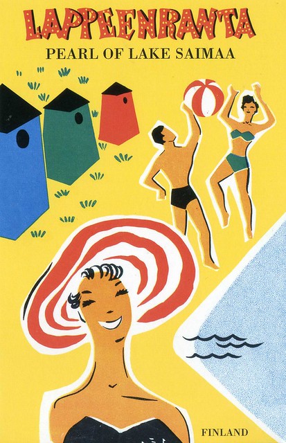
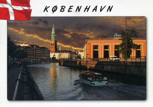
Lappeenranta is my old hometown. I was born there and lived there until I moved to Savonlinna for university, and then to England to live with Matt. There don't seem to be many nice postcards available of Lappeenranta - all I could find were horrible, tacky multiviews. I've only seen nice ones around Christmas time when the local energy company sends their clients these panoramic viewcards. They are supposed to be Christmas cards but they work perfectly well as postcards as well. ..except that they are always winter views. :p It's such a shame because there are quite a few very beautiful places in Lappeenranta. I guess it's the same with a lot of places all around the world, though. Anyway, I found this particular card in Helsinki, in the shop of Kiasma, the modern art museum. They had a number of similar cards - reprints of old travel posters. I might have to ask my sister to go see if there are any more left and if so, whether she could get me some. I really should have bought a few more. The picture here is an old poster, originally printed in 1958. It's an image from the Myllysaari beach. The colourful little huts are for getting changed before and after swimming. They used to be like this, individual, cute little huts but they have since been changed into more modern, bigger huts for several people. I can't remember when they were changed or if the old ones were even there when I was a kid in the 80's...

Lappeenranta is a city and municipality that resides on the shore of the lake Saimaa in South-Eastern Finland, about 30 kilometres from the Russian border. It belongs to the region of South Karelia. With approximately 72,000 inhabitants (31 January 2011) Lappeenranta is the 13th largest city in Finland.

Lappeenranta was originally formed around a headland pointing to lake Saimaa. In the 16th century, the market place moved from Lappee's old centre Kauskila to the current fortress headland. The first mention of Lapwes, as it was called, is in a privilege charter from 1542 that subjugated the market place under Viborg's authority.

The town was chartered in 1649 by Queen Christina of Sweden, legitimizing the trade in the then popular marketplace of Lapvesi. However, the parliamentary privilege charter and the coat of arms were attested in 1652 after the town layout by Erik Aspegren was affirmed. At the time, Lappeenranta was an important port for tar.

Between 1721 and 1743, Lappeenranta was the capital of Kymmenegård and Savonlinna province. In 1741 the battle of Villmanstrand was fought between the Swedish and Russian armies in the Russo-Swedish War of 1741–1743. The battle ended in a Russian victory. The town was pillaged, wooden structures including the provincial chancellery were burnt and the ecclesiastical archives damaged.

Lappeenranta is known as a summer city, mostly due to its closeness to the Lake Saimaa. In addition, its inland location means that summers tend to be warmer and winters colder than along the coastal areas.

The proximity of the Russian border is increasingly visible in the number of Russian tourists visiting the city. In fact, Lappeenranta is closer (211 km) to Saint Petersburg than Helsinki, the capital of Finland (221 km). The presence of Russians is noticeable by the many Russian registered cars on the streets and the use of signs in shops with Cyrillic letters.

Wednesday 1 June 2011

Anyer Beach, West Java, Indonesia

This postcard is pretty old, in my stardards anyway. It's way back from 1997 and was sent to me by a girl who was my penpal back then. She was Finnish but her family moved to Indonesia for a couple of years as her dad got a job offer in Jakarta. We haven't been writing to each other for years and years now, she suddenly just stopped writing to me and wouldn't reply to the couple of letters I sent to her, wondering what was going on. I do wish people would let me know if they don't want to/can't write to me anymore. This is especially true with this girl as her letters were always so long and lovely, I really enjoyed reading them. Anyway, she sent me a couple of postcards from Indonesia and I thought I'd post one of them here. She sent me this one when she'd only just moved to Indonesia and was still trying to get used to living in a new country. She'd only just been to this beach with her family and told me that the sea was almost as warm as the air (over +30 C). Ahhhh, I'd love to be on a beach like this right now!


West Java, with a population around 43 million, is the most populous and most densely populated province of Indonesia. Located on the island of Java, it is slightly smaller in area than densely populated Taiwan, but nearly double the population. Its capital city is Bandung.

West Java borders Jakarta and Banten province to the west, and Central Java to the east. To the north is Java Sea. To the south is the Indian Ocean. Unlike most other provinces in Indonesia which have their capitals in coastal area, the provincial capital Bandung is located in a mountainous area. Banten province was formerly part of West Java province, but was created a separate province in 2000. West Java is located in the densely populated Western third of Java island, which is home to 1 out of every 4 Indonesians.

West Java and Banten provinces have more mountains than any other province in Indonesia. The province's landscape is one of volcanic mountains, steep terrain, forest, mountains rivers, fertile agricultural land, and natural sea harbours.


The stamp is from a set of 2 greetings stamps issued in 1997.

Boston, USA

I received this lovely view of Boston from my postcard pal Laura earlier this year. I just love the colours here!


Boston is the capital of and largest city in Massachusetts, and is one of the oldest cities in the United States. The largest city in New England, Boston is regarded as the unofficial "Capital of New England" for its economic and cultural impact on the entire New England region. The city proper had a population of 617,594 according to the 2010 U.S. Census. Boston is also the anchor of a substantially larger metropolitan area called Greater Boston, home to 4.5 million people and the tenth-largest metropolitan area in the country.

With many colleges and universities within the city and surrounding area, Boston is an international center of higher education and a center for medicine. The city's economy is also based on research, electronics, engineering, finance, and high technology—principally biotechnology. As a result, the city is a leading finance center, ranking 12th in the Z/Yen top 20 Global Financial Centers. The city was also ranked number one for innovation, both globally and in North America, for a variety of reasons. Boston has been experiencing gentrification, and has one of the highest costs of living in the United States, though it remains high on world livability rankings, ranking third in the US and 37th globally.

On this postcard you can see the Hancock Tower, Boston's tallest building. The 60-story home office of the John Hancock Mutual Life Insurance Company is a Boston landmark.


The card came in an envelope as Laura also sent me a birthday greeting card. :) The stamp on the left is the well known definitive stamp from 2003, showing the American Clock. The stamp in the middle is from a set of 5 stamps issued earlier this year, depicting Latin Music Legends, the one here showing Tito Puente. The stamp on the right is from earlier this year as well, with the title 'Neon Celebrate!'.

Japan

This is a *very* special postcard to me. Not so much because of the images although they are very nice as well, but because it's my very first private swap postcard received via Postcrossing back in November 2007. It's also slightly before I discovered the forum. I still remember the excitement when I received this card, it was something very special.


Here you can see four traditional views from Japan:

Top left: Kinkaku-ji Temple, Kyoto
Bottom left: Shopping square, Asakusa Temple, Tokyo
Top right: Mt. Fuji and cherry blossoms
Bottom left: Himeji-jo Castle, Himeji

Kinkaku-ji is a Zen Buddhist temple in Kyoto, Japan. The garden complex is an excellent example of Muromachi period garden design. It is designated as a National Special Historic Site and a National Special Landscape, and it is one of 17 locations comprising the Historic Monuments of Ancient Kyoto World Heritage Site. It is also one of the most popular buildings in Japan, attracting a large number of visitors annually.

During the Onin war in 1950, all of the buildings in the complex aside from the pavilion were burned down. The present pavilion structure dates from 1955, when it was rebuilt. The reconstruction is said to be an exact copy of the original, although some doubt such an extensive gold-leaf coating was used on the original structure. In 1984, the coating of Japanese lacquer was found a little decayed, and a new coating as well as gilding with gold-leaf, much thicker than the original coatings, was completed in 1987. Additionally, the interior of the building, including the paintings and Yoshimitsu's statue, were also restored. Finally, the roof was restored in 2003.

If you want to read more about the temple, I can heartily recommend 'The Temple of the Golden Pavilion' by Yukio Mishima. It is a fictionalized version of the historical events leading to the destruction of the original temple, and very well written, too.

Himeji Castle is a hilltop Japanese castle complex located in Himeji in Hyōgo Prefecture. The castle is regarded as the finest surviving example of prototypical Japanese castle architecture, comprising a network of 83 buildings with advanced defensive systems from the feudal period.

Himeji Castle dates to 1333, when Akamatsu Norimura built a fort on top of Himeyama hill. The fort was dismantled and rebuilt as Himeyama Castle in 1346, and then remodeled into Himeji Castle two centuries later. Himeji Castle was then significantly remodeled in 1581 by Toyotomi Hideyoshi, who added a three-story castle keep. In 1600, Tokugawa Ieyasu awarded the castle to Ikeda Terumasa for his help in the Battle of Sekigahara, and Ikeda completely rebuilt the castle from 1601 to 1609, expanding it into a large castle complex. Several buildings were later added to the castle complex by Honda Tadamasa from 1617 to 1618.For over 400 years, Himeji Castle has remained intact, even throughout the extensive bombing of Himeji in World War II, and natural disasters such as the 1995 Great Hanshin earthquake.

Himeji Castle is the largest and most visited castle in Japan, and it was registered in 1993 as one of the first UNESCO World Heritage Sites in the country.


The stamp on the left is a definitive issued in 1997 in a set of 3, and probably the most common Japanese stamp on my mail from there.. The stamp on the right is from a set of 10 'Winter Greetings' stamps issued in 2005.

Malacca, Malaysia

It's always great to receive officials from friends from the Postcrossing forum - and send to them, too, I actually just pulled an address of a forum member earlier this morning. :) The card below is from the lovely Nurul in Malaysia.


MY-59465


Malacca (dubbed The Historic State or Negeri Bersejarah among locals) is the third smallest Malaysian state, after Perlis and Penang. It is located in the southern region of the Malay Peninsula, on the Straits of Malacca. It borders Negeri Sembilan to the north and the state of Johor to the south. The capital is Malacca City, which is 148 km south east of Malaysia's capital city Kuala Lumpur, 235 km north west to Johor's largest city Johor Bahru and 95 km north west to Johor's second largest city Batu Pahat. This historical city centre has been listed as a UNESCO World Heritage Site since 7 July 2008.

The card here shows a traditional Malacca Malay wooden stilt house with welcoming gesture "tangga batu" staircase. Nurul tells me that the staircase also symbolises the status of the family - the richer you are, the staircase will be very elaborate, with colourful tiles and bigger length staircase!


The stamp on the left is from a set of 8 stamps issued in 2005, depicting Birds of Malaysia. This one here is the Spotted Dove. The other stamp is from a set of 5 stamps issued in 2007, depicting insects.

Labadee, Haiti

Another seaside view, this time from a lot further away, though. This card isn't actually mailed directly from Haiti but it's still a nice addition to my collection, and a really nice view, too.


Labadee is a port located on the northern coast of Haiti. It is a private resort leased to Royal Caribbean International. Royal Caribbean International has contributed the largest proportion of tourist revenue to Haiti since 1986, employing 300 locals, allowing another 200 to sell their wares on the premises, and paying the Haitian government US$6 per tourist.

The resort is completely tourist-oriented, and is guarded by a private security force. The site is fenced off from the surrounding area, and passengers are not allowed to leave the property. A controlled group of Haitian merchants are given sole rights to sell their merchandise and establish their businesses in the resort. Although sometimes described as an island in advertisements, it is actually a peninsula contiguous with the island of Hispaniola. The cruise ship moors to the pier at Labadee capable of servicing the Oasis class ships, which was completed in late 2009.

Podgora, Croatia

It's supposed to get really warm here later this week, and in Finland it already is: I just had a txt from my mum saying it's +28 C in the shade! It'd be so nice if it was still like that next week, I much prefer these rare moments of sweating to the usual shivering/freezing. :P ...and on days like that, wouldn't it be great to be somewhere near to a sea? The place in this postcard would do nicely for me.. The Croatian coast looks SO pretty!


Podgora is a small town in the Split-Dalmatia county of Croatia. It is located on the Adriatic coastline of Dalmatia. The town has a population of 1,500 (2001) while the municipality of Podgora (which includes several smaller towns) has a population of about 3,000 (2001).

Podgora has a largely tourism-based economy. With its five hotels, it has four times as many beds as inhabitants. It is located 65 km south of Split and 135 km north of Dubrovnik.

This little fishing village, is mentioned first time in the 19 century as a birth place of Don Mihovil Pavlinović, priest, politician and writer, the first person to speak Croatian in the Dalmatian parliament, seeking the unification of Dalmatia and Croatia. The organized tourism started in Podgora in 1922, when the first hotel "Praha" was built. During the World War II, on September 10, 1942 the Yugoslav Partisans formed the Partisan Navy in Podgora. In 1962 Josip Broz Tito unveiled an impressive monument on a small hill above the port of Podgora, "The wings of a seagull", in remembrance of the World War II events.

Today, Podgora is a modern tourist destination, with favorable climate, the pebbly beaches and cozy bays with the sea which is relatively warm very early in the year. Podgora is an attractive seaside resort from the early spring to the late autumn. Its beautiful landscape, the azure sky and limpid sea make Podgora the peerless beauty spot of the Adriatic. The nature park Biokovo (1776 meters) offers possibilities for mountain biking, climbing and wanderings course. All kinds of water sports such as diving, water-skiing, windsurfing, rowing, waterpolo and swimming are very popular in Podgora. Tennis, football, basketball and mini golf courts are waiting for you. Your pleasure will be increased by the well organized trips to near islands, Dubrovnik, Split or the Krka waterfalls, by the unforgettable morning or evening promenades along the sea or by the romantic fishing expeditions at night.


The stamp is from a miniature sheet of two stamps issued in 2010, with the theme 'minerals'.